
Trip from Atlantic Beach, NC to West Raleigh, NC

Last recalculated Apr 16, 2026

Drive Time

3h 10m

Distance

153.2 mi

247 km

Drive Score

9/10

Great drive

Same Day?

Yes, doable

Fuel Cost

$24

one way

EV Charging

Unknown

Best Time to Leave

Save up to 35 min
4 AM
2h 59m ★
6 AM
3h 10m
8 AM
3h 34m
10 AM
3h 18m
12 PM
3h 16m
3 PM
3h 20m
5 PM
3h 32m
8 PM
3h 3m

Estimated drive times based on typical traffic patterns. Actual times may vary with weather, construction, and real-time conditions.

Downtown Atlantic Beach, NC, NC

Atlantic Beach, NC

Dominik Gryzbon

Downtown West Raleigh, NC, NC

West Raleigh, NC

Evgeniia Belman

Trip Overview

The drive from Atlantic Beach, NC to West Raleigh, NC covers 153.2 miles and takes about 3h 10m behind the wheel. This route is realistic as a one-day drive if you keep your stops efficient.

The route leans on Arendell Street, US 70, Goldsboro Bypass for much of the mileage, and the overall profile is turn-heavy local drive. The longest uninterrupted segment is about 68.8 miles on Arendell Street. At current regular gas prices, budget about $23.96 one way before food or hotel costs.

Trip Pace

Same-day drive is realistic

A same-day return is realistic if you keep stops short.

Break Rhythm

1 planned break

A short stop every 2 to 3 hours is enough for this drive.

Midpoint

76.6 miles from Atlantic Beach, NC

A natural place for your longest stop of the day , about 1h 37m into the drive .

Who Is This Route For?

Weekend Trip

Doable as a same-day drive at 3h 10m. Total distance: 153.2 miles.

Family Friendly

Moderate complexity with 1 natural rest stops along the way.

Solo Traveler

3h 10m drive, comfortable solo distance.

Scenic Drive

Turn-heavy local drive route profile with national parks nearby.

Drive Character

Expect a 3h 10m drive with frequent turns across 153.2 miles of local and secondary roads.

This route has more turning and local-road decision points than a simple highway run.
There are about 31 navigation steps in the underlying route data, so the final approach matters more than the middle miles.
Arendell Street is the longest continuous segment at about 68.8 miles.

How Hard Is This Drive?

Expect a hands-on drive with frequent turns and local roads rather than long highway stretches. You will hit about 14 points where you need to pay attention to lane position or signs. The trickiest moment comes early in the drive near South Kinston Avenue.

Driving Effort 6/10

Moderate - straightforward overall, but long enough or busy enough to require pacing

Balances navigation complexity with total wheel time.

This drive requires moderate attention. Across 153.2 miles you will encounter 14 spots where lane choice or exit timing matters. Not difficult for experienced highway drivers, but worth previewing the tricky sections before you go.

Where does it get tricky?

The main spots that need attention: near the start (South Kinston Avenue): Navigation decision point; at 0.1 miles (NC 58 / West Fort Macon Road): Navigation decision point; at 71.7 miles (US 70; US 258 / West New Bern Road): Highway fork - watch signs carefully. Lane positioning matters here.

Critical Maneuvers

5 of 14 key points

These are the spots where you need to pay the most attention. Preview them before you drive.

5
0 mi into trip | ~0m in | South Kinston Avenue

Turn right onto South Kinston Avenue

Navigation decision point

5
0.1 mi into trip | ~0m in | NC 58 / West Fort Macon Road

Turn right onto NC 58 / West Fort Macon Road

Navigation decision point

6
71.7 mi into trip | ~1h 30m in | US 70; US 258 / West New Bern Road

Keep slight right at fork onto US 70; US 258 / West New Bern Road

Highway fork - watch signs carefully. Lane positioning matters here

Use the straight lane.
5
138.8 mi into trip | ~2h 50m in | I 40

Merge onto I 40

Merge point - match speed before joining. Lane positioning matters here

Use the straight / slight right lanes.
8
149.6 mi into trip | ~3h 2m in

Take the exit toward NC 50 North, US 401 North, US 70 West: Raleigh Downtown

Exit ramp - move to the correct lane early. Lane positioning matters here. Multiple destination signs - pick the right one

Use the right lane. Exit 298B Toward NC 50 North, US 401 North, US 70 West: R...

Main Roads

Road Distance Duration
Arendell Street 68.8 mi 1h 25m
US 70 23.2 mi 29m
Goldsboro Bypass 20.2 mi 21m
I 40 10.8 mi 12m
US 70 BYP 10.1 mi 12m
Clayton Bypass Scenic Byway 10 mi 11m
West New Bern Road 3.3 mi 4m
West Vernon Avenue 1.6 mi 2m
Longest stretch: Arendell Street — 68.8 mi, about 1h 25m

Turn-by-Turn Driving Directions

Step-by-step road directions between Atlantic Beach, NC and West Raleigh, NC.

1

Start on West Terminal Boulevard

27 ft · 3 sec · West Terminal Boulevard
2

Turn right onto South Kinston Avenue

0.1 mi · 23 sec · South Kinston Avenue
3

Turn right onto NC 58

0.1 mi · 18 sec · West Fort Macon Road
4

Turn left onto Atlantic Beach Causeway

0.7 mi · 1 min · Atlantic Beach Causeway
5

Continue on Atlantic Beach Bridge

0.7 mi · 1 min · Atlantic Beach Bridge
6

Continue on South 23rd Street

0.1 mi · 13 sec · South 23rd Street
7

Turn left onto US 70

69 mi · 1 hr 25 min · Arendell Street
Use the left / straight / right lanes.
8

Continue on US 70; US 258

1.1 mi · 1 min · West New Bern Road
Use the straight lane.
9

Keep slight right at fork onto US 70; US 258

2.1 mi · 3 min · West New Bern Road
Use the straight lane.
10

Continue on US 70; US 258

1.6 mi · 2 min · West Vernon Avenue
Use the straight / right lanes.
11

Continue on US 70

9.6 mi · 11 min · US 70
Use the straight lane.
12

Continue on I 42

20 mi · 21 min · Goldsboro Bypass
13

Continue on US 70

1.2 mi · 1 min · US 70
Use the straight lane.
14

Continue on US 70

10 mi · 14 min · US 70
Use the straight lane.
15

Continue on US 70

2.0 mi · 2 min · US 70
Use the straight lane.
16

Keep slight left at fork onto US 70 BYP

10 mi · 12 min · US 70 BYP
17

Continue on I 42

10.0 mi · 11 min · Clayton Bypass Scenic Byway
18

Merge onto I 40

11 mi · 12 min · I 40
Use the straight / slight right lanes.
19

Take the exit

0.3 mi · 30 sec
Exit 298B Toward NC 50 North, US 401 North, US 70 West: Raleigh Downtown Use the right lane.
20

Turn straight onto US 70; US 401; NC 50

0.9 mi · 1 min · South Saunders Street
Use the straight / right lanes.
21

Turn slight right

0.3 mi · 43 sec
Toward Martin Luther King Junior Boulevard, Western Boulevard
22

Turn straight onto Martin Luther King Jr Boulevard

0.2 mi · 26 sec · Martin Luther King Jr Boulevard
23

Continue on Western Boulevard

1.2 mi · 2 min · Western Boulevard
Use the straight / right lanes.
24

Turn slight right

429 ft · 10 sec
Toward Pullen Road
25

Turn right onto Pullen Road

0.4 mi · 1 min · Pullen Road
26

Enter roundabout onto Pullen Road

63 ft · 2 sec · Pullen Road
27

Continue on Pullen Road

0.1 mi · 25 sec · Pullen Road
28

Enter roundabout onto Hillsborough Street

205 ft · 6 sec · Hillsborough Street
29

Continue on Hillsborough Street

503 ft · 14 sec · Hillsborough Street
30

Turn right onto Enterprise Street

44 ft · 1 sec · Enterprise Street
31

Arrive at destination

Enterprise Street

Trip Plan

Morning Departure

An early start around 7-8 AM gets you there with plenty of daylight left.

Evening Departure

A late afternoon start means arriving after dark. Morning is better.

You can normally do this drive in one day.
Plan roughly 1 meaningful break for fuel, food, and rest.
The halfway point lands around 76.6 miles from Atlantic Beach, NC, or about 1h 37m into the drive.
The longest continuous stretch on this route runs about 68.8 miles.

This is a comfortable same-day trip.

Departure

Before you leave

Start with fuel, water, and navigation already sorted so the first hour feels easy.

First stop

Around 34 miles or 43m in

Use this first pause for coffee, a restroom break, and a quick traffic check ahead.

Halfway reset

Around 76.6 miles or 1h 37m in

This is the best place for your longest stop, a real meal, and a full fuel check.

Final approach

Final hour starts around 2h 35m

Traffic, exits, and arrival timing usually matter more near West Raleigh, NC than in the middle of the route.

Before You Leave

+

Open the route before leaving Atlantic Beach, NC so your first major turns are already loaded.

+

Leave with enough water and a charging cable within reach, not packed away.

+

Check your fuel range against the first long segment, especially if you are starting outside city service areas.

Day 1

Settle into the route from Atlantic Beach, NC

This is one driving day of about 153.2 miles and 3h 10m.

Your first comfortable stop window is around 34 miles from Atlantic Beach, NC.
This route can stay practical as a one-day drive if traffic stays reasonable.
Plan about 1 real break rather than only quick fuel stops.
The longest stretch is on Arendell Street for about 68.8 miles.

Where to Stop

Rest stops, refuel points, and overnight suggestions along this route.

Halfway Point

Midpoint

About 76.6 mi from Atlantic Beach, NC · 1h 37m into the drive

Downtown Farmville, NC, NC

Mid-route town

Meal stop

Farmville, NC

77 mi into the route

Best for: Lunch, fuel, and a longer reset

This sits close to the middle of the route, so it works well for the longest stop of the day.

Pacing Suggestions

Neuse Forest, NC

Fuel and coffee

A short stop after about 34 miles helps settle the day before fatigue starts building.

Goldsboro, NC

Meal break

The midpoint is around 76.6 miles from Atlantic Beach, NC, which is a good place for a longer meal and fuel stop.

Before the longest stretch

Fuel check

Top up before Arendell Street if your tank is already low. That segment runs about 68.8 miles.

Arriving in West Raleigh, NC

The final approach into West Raleigh, NC usually feels slower than the middle of the drive, so avoid planning your tightest schedule at the very end.

Try to arrive with enough fuel left to skip an immediate station stop unless you already know the area around West Raleigh, NC.

These stop ideas are pacing suggestions — the exact town or exit can change with traffic, hotel plans, and fuel range.

National Parks Near This Route

Worth a detour if your schedule allows.

Cape Lookout National Seashore

Cape Lookout National Seashore

National Seashore

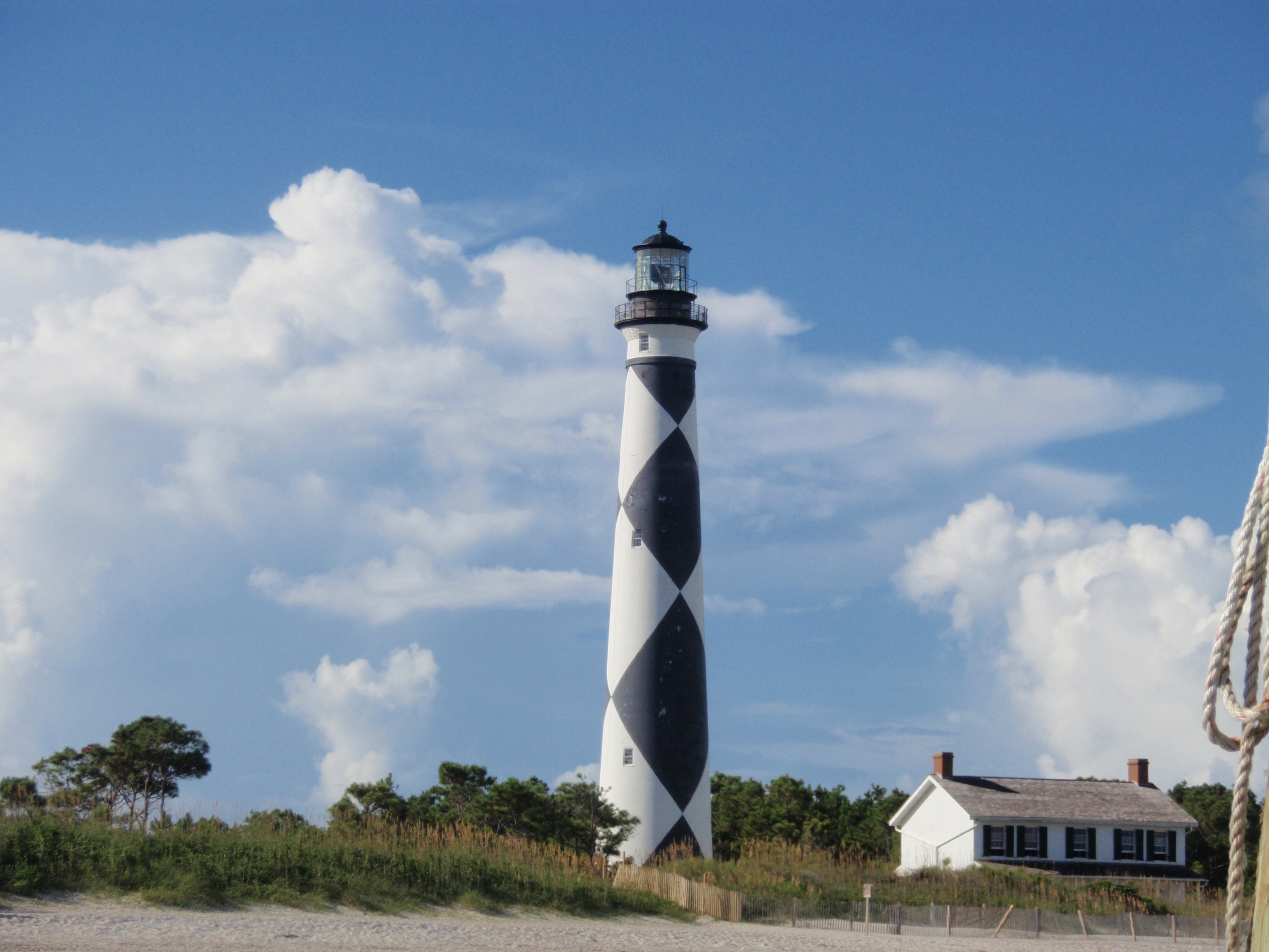
A boat ride three miles off-shore brings you to the barrier islands of Cape Lookout National Seashore. Horse watching, shelling, fishing, birding, camping, lighthouse climbing, and touring historic vi...

24 mi from route ~60 min detour Free
Danger: High Fire Danger and Fire Ban
Park Closure: Passenger Ferry Dock Closed
View on nps.gov

Park data from the National Park Service API. Alerts update every 2 hours.

Fuel & Cost

Regular Gas

$23.96 one way

$47.91 round trip

$3.97/gal 25.4 MPG avg 54 kg CO2
Fuel Type $/gal One Way Round Trip
midgrade $4.34 $26.19 $52.39
premium $4.70 $28.35 $56.71
diesel $5.61 $33.82 $67.65

No toll roads detected on this route.

Estimated Trip Cost (one way, 1 person)

Fuel

$24

Meals

$25–$50

Total

$49–$74

Rough estimate based on US averages. Hotel $80–$140/night, meals $25–$50/day.

Estimated CO2 emission: 53.6 kg one way. Prices: EIA weekly data, 2026-04-13.

Driving Electric?

About $16 in charging · 0 stops · 67% less CO2

Vehicle Type kWh Stops DC Fast Home Charge
Average EV 46 0 $16.09 $7.35
Efficient EV 38.3 0 $13.40 $6.13
EV Truck/SUV 61.3 0 $21.45 $9.80

Gas CO2

54 kg

EV CO2

18 kg (67% less)

This trip is well within single-charge range for most EVs. No charging stops needed if you start fully charged.

DC fast charging avg $0.35/kWh. Home charging avg $0.16/kWh. US grid CO2: 0.39 kg/kWh.

Travel Intel

Current conditions at both ends of the drive.

Forecast as of Jun 22, 2022

Origin

Atlantic Beach, NC

Evening in Atlantic Beach on Thursday

Local time

6:32 PM

EDT

Current temp

73°F

Unavailable

Live forecast

Destination

West Raleigh, NC

Evening in West Raleigh on Thursday

Local time

6:32 PM

EDT

Current temp

68°F

Unavailable

Live forecast

49°F

Farmville, NC

77 mi in

Seasonal Notes

Summer travel usually means heavier construction, hotter rest stops, and busier weekend traffic around major cities.

Winter travel shortens daylight, so a route that looks manageable on paper can feel much longer after dark.

Holiday weekends tend to make both departure and arrival windows slower than the raw route time suggests.

Time zone

Same local time

Origin and destination are on the same clock, so arrival timing is easier to judge at a glance.

Temperature spread

5 degrees cooler at arrival

A meaningful temperature swing is a good cue to rethink layers, water, and how soon you want to arrive.

Road read

3h 10m on the road

Use the two city cards together: check the sky where you start, then compare it with the local time and temperature at arrival.

Weather data from the National Weather Service. Conditions may change; check closer to your travel date.

Frequently Asked Questions

The drive from Atlantic Beach, NC to West Raleigh, NC covers 153.2 miles and takes about 3h 10m without stops. Add 15-30 minutes for a fuel or rest stop on longer drives.
The main roads are Arendell Street, US 70, Goldsboro Bypass. Expect a mix of highway and local road driving.
This is a comfortable same-day trip.
The midpoint is about 76.6 miles from Atlantic Beach, NC. Look for rest areas, gas stations, or food options near the halfway mark.
At current regular gas prices, expect to spend about $23.96 one way. This estimate uses 25.4 MPG — your actual cost will vary with your vehicle's fuel efficiency and current gas prices.
An early start around 7-8 AM gets you there with plenty of daylight left. A late afternoon start means arriving after dark. Morning is better.
Plan about 1 meaningful break for fuel, food, or rest. A short stop every 2 to 3 hours is enough for this drive.
This drive requires moderate attention. Across 153.2 miles you will encounter 14 spots where lane choice or exit timing matters. Not difficult for experienced highway drivers, but worth previewing the tricky sections before you go.
The main spots that need attention: near the start (South Kinston Avenue): Navigation decision point; at 0.1 miles (NC 58 / West Fort Macon Road): Navigation decision point; at 71.7 miles (US 70; US 258 / West New Bern Road): Highway fork - watch signs carefully. Lane positioning matters here.
The route from Atlantic Beach, NC to West Raleigh, NC does not surface many named destination signs beyond the main corridor.
Yes. Nearby national parks include Cape Lookout National Seashore.

Was this helpful?

Thanks for your feedback!

Your tip has been submitted. Thanks!

/500

Explore More

Return Trip

West Raleigh, NC to Atlantic Beach, NC

Plan the drive back the other way.

153.5 mi 3h 10m

Explore more options from Atlantic Beach, NC or browse trips ending in West Raleigh, NC.

Looking for more statewide routes? Browse NC road trips.

Explore maps for Atlantic Beach, NC or West Raleigh, NC on MapSof.net.