The drive from Bayard, NE to Fremont, NE covers 427 miles and takes about 7h 43m behind the wheel.
This route is realistic as a one-day drive if you keep your stops efficient.
The route leans on I 80, US 26, US Highway 26 for much of the mileage,
and the overall profile is mostly highway.
The longest uninterrupted segment is about 278.3 miles on I 80.
At current regular gas prices, budget about $66.76 one way before food or hotel costs.
Trip Pace
Same-day drive is realistic
A same-day return is possible, but it will make for a full day on the road.
Break Rhythm
2 planned breaks
Plan on a short reset every 3 to 4 hours to stay fresh behind the wheel.
Midpoint
213.5 miles from Bayard, NE
A natural place for your longest stop of the day
, about 3h 58m into the drive
.
Main Roads
Road
Distance
Duration
I 80
278.3 mi
4h 42m
US 26
84 mi
1h 39m
US Highway 26
12.5 mi
15m
Highway 77
12.2 mi
14m
County Road 11
11.6 mi
13m
North 56th Street
11.1 mi
12m
County Road M
5.2 mi
6m
Main Street
3.7 mi
5m
Longest stretch:
I 80
— 278.3 mi, about 4h 42m
Turn-by-Turn Driving Directions
Step-by-step road directions between Bayard, NE and Fremont, NE.
1
Start on US 26
2.7 mi·3 min·Main Street
2
At end of road, turn left onto US 26; N-92
13 mi·15 min·US Highway 26
3
Turn left onto US 26; US 385
1.0 mi·1 min·Main Street
4
Continue on US 26
84 mi·1 hr 39 min·US 26
5
Turn right onto North Spruce Street
2.7 mi·4 min·North Spruce Street
6
Turn left onto US 26; US 30; N-61; I 80 Alt
305 ft·7 sec·US 26; US 30; N-61; I 80 Alt
7
Turn right onto US 26; N-61
0.9 mi·1 min·South Highway 26/61
8
Turn left
0.4 mi·52 sec
Toward I 80 east
9
Merge onto I 80
278 mi·4 hr 42 min·I 80
10
Take the exit onto US 77
0.4 mi·46 sec·US 77
Toward US 77 North: Fremont, Wahoo
11
Turn left onto US 77
11 mi·12 min·North 56th Street
12
Continue on US 77
0.1 mi·9 sec·South Highway 77
13
Continue on US 77
2.2 mi·2 min·County Road 18
14
Continue on US 77
12 mi·13 min·Highway 77
Use the left / straight / right lanes.
15
Enter roundabout onto US 77; N-92
217 ft·2 sec·County Road M
16
Continue on US 77; N-92
5.2 mi·6 min·County Road M
17
Turn left onto US 77
12 mi·13 min·County Road 11
Use the straight / right lanes.
18
Continue on US 77
0.6 mi·42 sec·Highway 77
19
Enter roundabout onto S-27E
341 ft·4 sec·South Broad Street
20
Continue on S-27E
1.6 mi·3 min·South Broad Street
21
Turn right onto West 4th Street
188 ft·13 sec·West 4th Street
22
Turn left
143 ft·10 sec
23
Arrive at destination
Trip Plan
Morning Departure
Start early — leave by 6-7 AM to arrive at a reasonable hour.
Evening Departure
This is a long drive — plan for a morning departure or consider splitting it into two days.
You can normally do this drive in one day.
Plan roughly 2 meaningful breaks for fuel, food, and rest.
The halfway point lands around 213.5 miles from Bayard, NE, or about 3h 58m into the drive.
The longest continuous stretch on this route runs about 278.3 miles.
This is a comfortable same-day trip.
Departure
Before you leave
Start with fuel, water, and navigation already sorted so the first hour feels easy.
First stop
Around 94 miles or 1h 52m in
Use this first pause for coffee, a restroom break, and a quick traffic check ahead.
Halfway reset
Around 213.5 miles or 3h 58m in
This is the best place for your longest stop, a real meal, and a full fuel check.
Final approach
Final hour starts around 6h 34m
Traffic, exits, and arrival timing usually matter more near Fremont, NE than in the middle of the route.
Before You Leave
+
Open the route before leaving Bayard, NE so your first major turns are already loaded.
+
Leave with enough water and a charging cable within reach, not packed away.
+
Check your fuel range against the first long segment, especially if you are starting outside city service areas.
+
Pick one backup stop option before the midpoint in case traffic changes your pacing.
Day 1
Settle into the route from Bayard, NE
This is one driving day of about 427 miles and 7h 43m.
Your first comfortable stop window is around 94 miles from Bayard, NE.
This route can stay practical as a one-day drive if traffic stays reasonable.
Plan about 2 real breaks rather than only quick fuel stops.
The longest stretch is on I 80 for about 278.3 miles.
Where to Stop
Rest stops, refuel points, and overnight suggestions along this route.
Place data sourced from public business listings. Hours and availability may vary.
Heads-up: tricky spots
5 of 13
5 decision points cluster between mile 100.2 and 413.1 — GPS handles the exact turns, but know they're coming. Your lane choice matters more than the turn itself.
4
100.2 mi into trip|~2h in|North Spruce Street
Turn right onto North Spruce Street
Navigation decision point
4
102.9 mi into trip|~2h 4m in|US 26; US 30; N-61; I 80 Alt
Turn left onto US 26; US 30; N-61; I 80 Alt
Navigation decision point
4
102.9 mi into trip|~2h 4m in|US 26; N-61 / South Highway 26/61
Turn right onto US 26; N-61 / South Highway 26/61
Navigation decision point
5
382.5 mi into trip|~6h 50m in|US 77
Take the exit onto US 77 toward US 77 North: Fremont, Wahoo
Exit ramp - move to the correct lane early. Multiple destination signs - pick the right one
Toward US 77 North: Fremont, Wahoo
6
413.1 mi into trip|~7h 25m in|US 77 / County Road 11
Turn left onto US 77 / County Road 11
Lane positioning matters here
Use the straight / right lanes.
Fuel & Cost
Regular Gas
$66.76 one way
$133.51 round trip
$3.97/gal25.4 MPG avg149 kg CO2
Fuel Type
$/gal
One Way
Round Trip
midgrade
$4.36
$73.30
$146.59
premium
$4.89
$82.17
$164.34
diesel
$5.61
$94.28
$188.55
No toll roads detected on this route.
Estimated Trip Cost (one way, 1 person)
Fuel
$67
Meals
$25–$50
Total
$92–$117
Rough estimate based on US averages. Hotel $80–$140/night, meals $25–$50/day.
Estimated CO2 emission: 149.4 kg one way.
Prices: EIA weekly data, 2026-04-13.
Driving Electric?
About $45 in charging
· 1 stop
· 66% less CO2
Vehicle Type
kWh
Stops
DC Fast
Home Charge
Average EV
128.1
1
$44.83
$20.50
Efficient EV
106.8
1
$37.36
$17.08
EV Truck/SUV
170.8
2
$59.78
$27.33
Gas CO2
149 kg
EV CO2
50 kg (66% less)
Plan for 1 charging stop. A 30-minute DC fast charge mid-route should be enough to complete the trip comfortably.
DC fast charging avg $0.35/kWh. Home charging avg $0.16/kWh. US grid CO2: 0.39 kg/kWh.
Travel Intel
Current conditions at both ends of the drive.
Forecast as of Apr 15, 2026
Origin
Bayard, NE
Afternoon
in Bayard on Saturday
Local time
12:29 PM
MDT
Current temp
45°F
Unavailable
Live forecast
Destination
Fremont, NE
Afternoon
in Fremont on Saturday
Local time
1:29 PM
CDT
Current temp
77°F
Unavailable
Live forecast
Seasonal Notes
Summer travel usually means heavier construction, hotter rest stops, and busier weekend traffic around major cities.
Winter travel shortens daylight, so a route that looks manageable on paper can feel much longer after dark.
Holiday weekends tend to make both departure and arrival windows slower than the raw route time suggests.
Time zone
1 hour later
The destination clock does not match departure time, so double-check hotel check-in windows and late arrival plans.
Temperature spread
32 degrees warmer at arrival
A meaningful temperature swing is a good cue to rethink layers, water, and how soon you want to arrive.
Road read
7h 43m on the road
Start early — leave by 6-7 AM to arrive at a reasonable hour.
Weather data from the National Weather Service. Conditions may change; check closer to your travel date.
National Parks Near This Route
Worth a detour if your schedule allows.
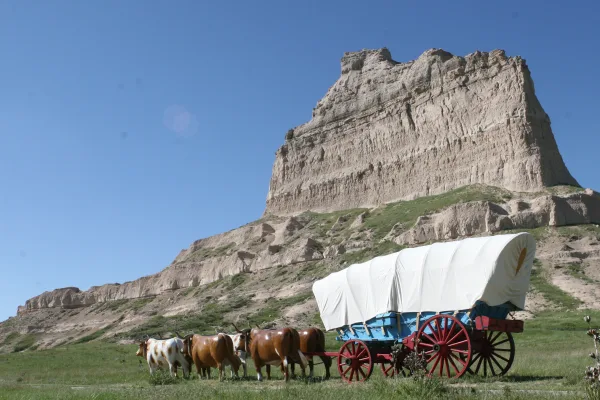
Scotts Bluff National Monument
National Monument
Towering 800 feet above the North Platte River, Scotts Bluff has served as a landmark for peoples from Native Americans to emigrants on the Oregon, California and Mormon Trails to modern travelers. Ri...
Park data from the National Park Service API. Alerts update every 2 hours.
More Details
What kind of drive is this?
427 mi in 7h 43m, mostly highway — 278.3 mi of that is on I 80.
91% highway — fuel and pacing are the main things to plan.
23 navigation steps total — most of the decisions cluster near the start and finish.
Longest single stretch: 278.3 mi on I 80.
How Hard Is This Drive?
4/10
This is a straightforward highway drive that stays mostly on I 80 and US 26. There are only a few real navigation decisions along the way. The trickiest moment comes around 100.2 miles in near North Spruce Street.
Driving Effort4/10
Easy - simple navigation with a manageable amount of wheel time
Balances navigation complexity with total wheel time.
The route itself is not hard, but at 7h 43m, endurance matters. Plan breaks every 2-3 hours. The 13 decision points are all manageable with basic attention.
Where does it get tricky?
The main spots that need attention: at 100.2 miles (North Spruce Street): Navigation decision point; at 102.9 miles (US 26; US 30; N-61; I 80 Alt): Navigation decision point; at 102.9 miles (US 26; N-61 / South Highway 26/61): Navigation decision point.
Towns Mentioned on Route Signs
Based on OSRM destination-sign hints, not a full list of every settlement the road passes.
On the drive from Bayard, NE to Fremont, NE, road signs begin pointing toward Wahoo along the way.
Wahoo
382.5 mi in|~6h 50m|via US 77
Who Is This Route For?
Weekend Trip
Doable as a same-day drive at 7h 43m. Total distance: 427 miles.
Family Friendly
Moderate complexity with 2 natural rest stops along the way.
The longest stretch is about 278.3 miles on I 80. The full list of main roads is in the Roads section above.
We did not find dedicated rest areas on this route. For a drive this long, plan bathroom and stretch breaks around gas stations, fast-food stops, or small-town downtowns — check the Nearby Places section for options.
It helps. This is a long drive, so arriving tired and in the dark compounds. If the last hour of the trip is on surface roads or mountain grades, aim to arrive at Fremont, NE before sunset when you can. Check the Trip Plan for departure windows that land you in daylight.
Only with planning. This is a long drive for kids — consider splitting it into two days rather than pushing through. Plan at least 2 meaningful breaks. Dedicated rest areas are limited, so plan gas or food stops as your bathroom breaks.
Mostly yes along the main roads, but rural stretches through NE can have sparse or no coverage. Before you leave, download offline Google Maps or Apple Maps for the route, and consider downloading music or podcasts instead of streaming. If you depend on data for navigation, keep a paper backup of the turn-by-turn directions.
The main spots that need attention: at 100.2 miles (North Spruce Street): Navigation decision point; at 102.9 miles (US 26; US 30; N-61; I 80 Alt): Navigation decision point; at 102.9 miles (US 26; N-61 / South Highway 26/61): Navigation decision point.
Yes — Scotts Bluff National Monument. See the National Parks section for detour distances and tips on detours.
Not recommended in a single day. At 7.7 hours each way, a round trip means 15.5 hours of driving — that is an unsafe level of fatigue for most drivers. Plan at least one night at Fremont, NE before the return drive.
How this page is built
Compiled by the Trip.ovh planning team at COD Solutions Oy from open government datasets — OSRM over OpenStreetMap for geometry, EIA for fuel prices, and NPS for national parks. See our methodology for refresh cadence and limitations.