Trip from Biddeford, ME to Calais, ME

Drive Time

4h 55m

Distance

240.8 mi

388 km

Drive Score

8/10

Great drive

Same Day?

Yes, doable

Fuel Cost

$39

one way

EV Charging

Loading...

station data

Best Time to Leave

Save up to 40 min
4 AM
4h 42m ★
6 AM
4h 55m
8 AM
5h 22m
10 AM
5h 5m
12 PM
5h 2m
3 PM
5h 6m
5 PM
5h 21m
8 PM
4h 47m

Estimated drive times based on typical traffic patterns. Actual times may vary with weather, construction, and real-time conditions.

Downtown Biddeford, ME, ME

Biddeford, ME

Phil Evenden

Downtown Calais, ME, ME

Calais, ME

Omran Soliman

Trip Overview

The drive from Biddeford, ME to Calais, ME covers 240.8 miles and takes about 4h 55m behind the wheel. This route is realistic as a one-day drive if you keep your stops efficient.

The route leans on I 395, Maine Turnpike, I 295 for much of the mileage, and the overall profile is highway-focused drive. The longest uninterrupted segment is about 90.1 miles on I 395. At current regular gas prices, budget about $38.55 one way before food or hotel costs.

Trip Pace

Same-day drive is realistic

A same-day return is possible, but it will make for a full day on the road.

Break Rhythm

1 planned break

Plan on a short reset every 3 to 4 hours to stay fresh behind the wheel.

Midpoint

120.4 miles from Biddeford, ME

A natural place for your longest stop of the day , about 2h 16m into the drive .

Drive Character

This is a 4h 55m highway drive covering 240.8 miles, with most of the trip on I 395 and Maine Turnpike. The longest continuous stretch is about 90.1 miles on I 395.

Most of the miles stay on highways, which makes pacing and fuel planning easier than turn-by-turn city driving.
There are about 19 navigation steps in the underlying route data, so the final approach matters more than the middle miles.
I 395 is the longest continuous segment at about 90.1 miles.

Elevation Profile

Mostly flat terrain

550 ft 74 ft

Total Climb

687 ft

Total Descent

665 ft

Highest Point

550 ft

~190.6 mi in

Elevation Range

476 ft

How Hard Is This Drive?

This is a straightforward highway drive that stays mostly on I 395 and Maine Turnpike. There are only a few real navigation decisions along the way. The trickiest moment comes around 2.3 miles in.

Route Complexity 4/10

Easy - simple navigation with a manageable amount of wheel time

This is a straightforward 4h 55m drive. You will face about 10 decision points, but nothing that requires special attention if you follow navigation.

Where does it get tricky?

The main spots that need attention: at 2.3 miles: Navigation decision point; at 11.6 miles (I 295): Highway fork - watch signs carefully. Lane positioning matters here; at 143.3 miles: Exit ramp - move to the correct lane early. Multiple destination signs - pick the right one.

Critical Maneuvers

5 of 10 key points

These are the spots where you need to pay the most attention. Preview them before you drive.

4
2.3 mi into trip | ~4m in

Take the ramp toward I 95 North: Portland

Navigation decision point

Toward I 95 North: Portland
8
11.6 mi into trip | ~14m in | I 295

Keep slight right at fork onto I 295 toward Downtown Portland

Highway fork - watch signs carefully. Lane positioning matters here

Use the slight right lane. Exit 44 Toward Downtown Portland
6
143.3 mi into trip | ~2h 41m in

Take the exit toward I 395 South, ME 15 South: Bangor, Brewer

Exit ramp - move to the correct lane early. Multiple destination signs - pick the right one

Exit 182A Toward I 395 South, ME 15 South: Bangor, Brewer
4
238.6 mi into trip | ~4h 51m in | US 1; ME 9 / Baring Street

Enter roundabout onto US 1; ME 9 / Baring Street

Roundabout - know your exit number before entering

5
240.7 mi into trip | ~4h 55m in | Germain Street

Turn left onto Germain Street

Navigation decision point

Towns Along This Route

On the drive from Biddeford, ME to Calais, ME, road signs begin pointing toward Brewer along the way.

Brewer

143.3 mi in | ~2h 41m

Main Roads

Road Distance Duration
I 395 90.1 mi 2h 3m
Maine Turnpike 88 mi 1h 35m
I 295 52.5 mi 1h 1m
North Street 2.8 mi 4m
Route 1 2.6 mi 2m
Baring Street 2.4 mi 2m
Main Street 0.9 mi 1m
Lincoln Street 0.3 mi 1m
Longest stretch: I 395 — 90.1 mi, about 2h 3m

Turn-by-Turn Driving Directions

Step-by-step road directions between Biddeford, ME and Calais, ME.

1

Start on US 1 Alternate

0.9 mi · 1 min · Main Street
2

Turn left onto ME 112

162 ft · 5 sec · Beach Street
3

Continue on ME 5; ME 112

1.4 mi · 2 min · North Street
4

Take the ramp

0.6 mi · 1 min
Toward I 95 North: Portland
5

Merge onto I 95

8.8 mi · 9 min · Maine Turnpike
6

Keep slight right at fork onto I 295

52 mi · 1 hr 1 min · I 295
Exit 44 Toward Downtown Portland Use the slight right lane.
7

Merge onto I 95

79 mi · 1 hr 25 min · Maine Turnpike
8

Take the exit

0.4 mi · 48 sec
Exit 182A Toward I 395 South, ME 15 South: Bangor, Brewer
9

Merge onto I 395; ME 15

0.7 mi · 55 sec · I 395; ME 15
10

Continue on I 395; ME 9; ME 15

89 mi · 2 hr 2 min · I 395; ME 9; ME 15
11

Continue on US 1; ME 9

0.2 mi · 13 sec · Houlton Road
12

Continue on US 1; ME 9

2.6 mi · 2 min · Route 1
13

Continue on US 1; ME 9

1.9 mi · 2 min · Baring Street
14

Enter roundabout onto US 1; ME 9

67 ft · 0 sec · Baring Street
15

Continue on US 1; ME 9

0.5 mi · 45 sec · Baring Street
16

Continue on US 1; ME 9

1.3 mi · 2 min · North Street
17

Turn right onto Lincoln Street

0.3 mi · 1 min · Lincoln Street
18

Turn left onto Germain Street

448 ft · 19 sec · Germain Street
19

Arrive at destination

Germain Street

Trip Plan

Morning Departure

An early start around 7-8 AM gets you there with plenty of daylight left.

Evening Departure

A late afternoon start means arriving after dark. Morning is better.

You can normally do this drive in one day.
Plan roughly 1 meaningful break for fuel, food, and rest.
The halfway point lands around 120.4 miles from Biddeford, ME, or about 2h 16m into the drive.
The longest continuous stretch on this route runs about 90.1 miles.

This is a comfortable same-day trip.

Departure

Before you leave

Start with fuel, water, and navigation already sorted so the first hour feels easy.

First stop

Around 80 miles or 1h 33m in

Use this first pause for coffee, a restroom break, and a quick traffic check ahead.

Halfway reset

Around 120.4 miles or 2h 16m in

This is the best place for your longest stop, a real meal, and a full fuel check.

Final approach

Final hour starts around 3h 55m

Traffic, exits, and arrival timing usually matter more near Calais, ME than in the middle of the route.

Before You Leave

+

Open the route before leaving Biddeford, ME so your first major turns are already loaded.

+

Leave with enough water and a charging cable within reach, not packed away.

+

Check your fuel range against the first long segment, especially if you are starting outside city service areas.

Day 1

Settle into the route from Biddeford, ME

This is one driving day of about 240.8 miles and 4h 55m.

Your first comfortable stop window is around 80 miles from Biddeford, ME.
This route can stay practical as a one-day drive if traffic stays reasonable.
Plan about 1 real break rather than only quick fuel stops.
The longest stretch is on I 395 for about 90.1 miles.

Where to Stop

Rest stops, refuel points, and overnight suggestions along this route.

Halfway Point

Midpoint

About 120.4 mi from Biddeford, ME · 2h 16m into the drive

Mid-route town

Meal stop

Appleton, ME

120 mi into the route

Best for: Lunch, fuel, and a longer reset

This sits close to the middle of the route, so it works well for the longest stop of the day.

Pacing Suggestions

Brunswick, ME

Fuel and coffee

A short stop after about 80 miles helps settle the day before fatigue starts building.

Appleton, ME

Meal break

The midpoint is around 120.4 miles from Biddeford, ME, which is a good place for a longer meal and fuel stop.

Before the longest stretch

Fuel check

Top up before I 395 if your tank is already low. That segment runs about 90.1 miles.

Arriving in Calais, ME

The final approach into Calais, ME usually feels slower than the middle of the drive, so avoid planning your tightest schedule at the very end.

Try to arrive with enough fuel left to skip an immediate station stop unless you already know the area around Calais, ME.

These stop ideas are pacing suggestions — the exact town or exit can change with traffic, hotel plans, and fuel range.

National Parks Near This Route

Worth a detour if your schedule allows.

Frances Perkins National Monument

Frances Perkins National Monument

National Monument

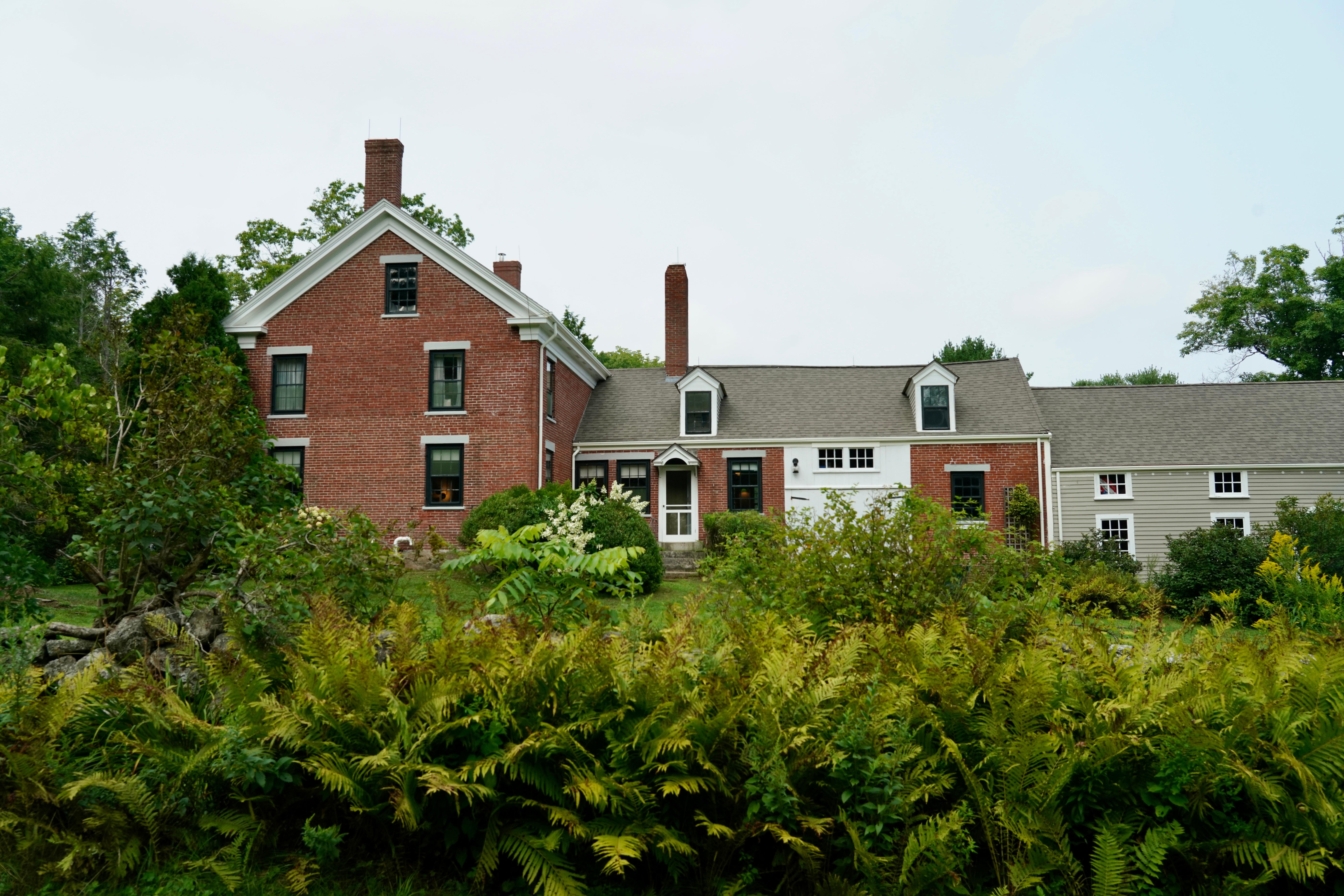
Known as the first woman to hold a presidential cabinet position and the “Woman behind the New Deal,” Frances Perkins championed many labor rights that Americans enjoy today, including safety standard...

17 mi from route ~42 min detour Free near mile 58.1
Park Closure: For Current Visitor Information
View on nps.gov

Park data from the National Park Service API. Alerts update every 2 hours.

Fuel & Cost

Regular Gas

$38.55 one way

$77.09 round trip

$4.07/gal 25.4 MPG avg 84 kg CO2
Fuel Type $/gal One Way Round Trip
midgrade $4.46 $42.25 $84.51
premium $4.83 $45.77 $91.54
diesel $5.64 $53.50 $106.99

Estimated Tolls: $5.28

Maine Turnpike (88 mi) $5.28

Toll estimates based on average 2024-2025 rates. EZ-Pass/SunPass discounts may lower the actual cost.

Estimated Trip Cost (one way, 1 person)

Fuel

$39

Tolls

$5

Meals

$25–$50

Total

$69–$94

Rough estimate based on US averages. Hotel $80–$140/night, meals $25–$50/day.

Estimated CO2 emission: 84.3 kg one way. Prices: EIA weekly data, 2026-04-06.

Driving Electric?

About $25 in charging · 0 stops · 67% less CO2

Vehicle Type kWh Stops DC Fast Home Charge
Average EV 72.2 0 $25.28 $11.56
Efficient EV 60.2 0 $21.07 $9.63
EV Truck/SUV 96.3 1 $33.71 $15.41

Gas CO2

84 kg

EV CO2

28 kg (67% less)

Plan for 0 charging stops, roughly every 270 miles. Allow 25-40 minutes per stop at a DC fast charger.

DC fast charging avg $0.35/kWh. Home charging avg $0.16/kWh. US grid CO2: 0.39 kg/kWh.

Travel Intel

Current conditions at both ends of the drive.

Forecast data refreshed 2 hours ago

Origin

Biddeford, ME

Evening in Biddeford on Sunday

Local time

6:01 PM

EDT

Current temp

53°F

Mostly Cloudy

S 10 mph 8% chance Live forecast

Destination

Calais, ME

Evening in Calais on Sunday

Local time

6:01 PM

EDT

Current temp

53°F

Sunny

NW 5 mph 0% chance Live forecast

Along the Route

63°F

Appleton, ME

120 mi in

Seasonal Notes

Summer travel usually means heavier construction, hotter rest stops, and busier weekend traffic around major cities.

Winter travel shortens daylight, so a route that looks manageable on paper can feel much longer after dark.

Holiday weekends tend to make both departure and arrival windows slower than the raw route time suggests.

Time zone

Same local time

Origin and destination are on the same clock, so arrival timing is easier to judge at a glance.

Temperature spread

Very similar conditions

Both ends of the route are sitting at about the same temperature right now.

Road read

4h 55m on the road

An early start around 7-8 AM gets you there with plenty of daylight left.

Weather data from the National Weather Service. Conditions may change; check closer to your travel date.

Frequently Asked Questions

The drive from Biddeford, ME to Calais, ME covers 240.8 miles and takes about 4h 55m without stops. Add 15-30 minutes for a fuel or rest stop on longer drives.
The main roads are I 395, Maine Turnpike, I 295. Most of the drive stays on highways, so watch for ramps and exits.
This is a comfortable same-day trip.
The midpoint is about 120.4 miles from Biddeford, ME. Look for rest areas, gas stations, or food options near the halfway mark.
At current regular gas prices, expect to spend about $38.55 one way. This estimate uses 25.4 MPG — your actual cost will vary with your vehicle's fuel efficiency and current gas prices.
An early start around 7-8 AM gets you there with plenty of daylight left. A late afternoon start means arriving after dark. Morning is better.
Plan about 1 meaningful break for fuel, food, or rest. Plan on a short reset every 3 to 4 hours to stay fresh behind the wheel.
This is a straightforward 4h 55m drive. You will face about 10 decision points, but nothing that requires special attention if you follow navigation.
The main spots that need attention: at 2.3 miles: Navigation decision point; at 11.6 miles (I 295): Highway fork - watch signs carefully. Lane positioning matters here; at 143.3 miles: Exit ramp - move to the correct lane early. Multiple destination signs - pick the right one.
On the drive from Biddeford, ME to Calais, ME, road signs begin pointing toward Brewer along the way.
Mostly flat terrain. The route ranges from 74 ft to 550 ft elevation with about 687 ft of total climbing.

Was this route helpful?

Thanks for your feedback!

Your tip has been submitted. Thanks!

/500

Explore More

Explore more options from Biddeford, ME or browse trips ending in Calais, ME.

Looking for more statewide routes? Browse ME road trips.

Explore maps for Biddeford, ME or Calais, ME on MapSof.net.