Trip from Big Pine Key, FL to Jacksonville, FL

Drive Time

9h 26m

Distance

473.1 mi

761 km

Drive Score

8/10

Great drive

Same Day?

2-day trip

Fuel Cost

$79

one way

EV Charging

None

0 DC fast

Best Time to Leave

Save up to 25 min
4 AM
9h 18m ★
6 AM
9h 26m
8 AM
9h 43m
10 AM
9h 32m
12 PM
9h 31m
3 PM
9h 33m
5 PM
9h 42m
8 PM
9h 21m

Estimated drive times based on typical traffic patterns. Actual times may vary with weather, construction, and real-time conditions.

Downtown Jacksonville, FL, FL

Jacksonville, FL

Mike Jones

Trip Overview

The drive from Big Pine Key, FL to Jacksonville, FL covers 473.1 miles and takes about 9h 26m behind the wheel. It usually feels better as a 2-day road trip than as one long push.

The route leans on I 95, Florida's Turnpike, New Seven Mile Bridge for much of the mileage, and the overall profile is highway-focused drive. The longest uninterrupted segment is about 219.7 miles on I 95. At current regular gas prices, budget about $79.03 one way before food or hotel costs.

Trip Pace

Best split across 2 days

Treat the return leg as its own travel day rather than an afterthought.

Break Rhythm

2 planned breaks

Plan on a short reset every 3 to 4 hours to stay fresh behind the wheel.

Midpoint

236.5 miles from Big Pine Key, FL

A natural place for your longest stop of the day , about 5h 5m into the drive .

Drive Character

This is a 9h 26m highway drive covering 473.1 miles, with most of the trip on I 95 and Florida's Turnpike. The longest continuous stretch is about 219.7 miles on I 95.

Most of the miles stay on highways, which makes pacing and fuel planning easier than turn-by-turn city driving.
There are about 26 navigation steps in the underlying route data, so the final approach matters more than the middle miles.
I 95 is the longest continuous segment at about 219.7 miles.

How Hard Is This Drive?

This is a straightforward highway drive that stays mostly on I 95 and Florida's Turnpike. This route has several spots where lane changes, forks, or exits need your full attention. The trickiest moment comes around 96.8 miles in.

Route Complexity 9/10

High effort - long or complex enough to need steady focus all day

This is a demanding drive. With 22 significant decision points across 473.1 miles, you will need to stay alert — especially through interchange areas and urban stretches. Consider splitting it into segments if you are not comfortable with fast highway navigation.

Where does it get tricky?

The main spots that need attention: at 96.8 miles: Exit ramp - move to the correct lane early. Lane positioning matters here. Multiple destination signs - pick the right one; at 143.5 miles (Homestead Extension of Florida's Turnpike): Highway fork - watch signs carefully. Lane positioning matters here. Multiple destination signs - pick the right one; at 249.3 miles: Exit ramp - move to the correct lane early. Lane positioning matters here. Multiple destination signs - pick the right one.

Critical Maneuvers

5 of 22 key points

These are the spots where you need to pay the most attention. Preview them before you drive.

7
96.8 mi into trip | ~2h 27m in

Take the exit toward Miami, Orlando, Florida's Turnpike North

Exit ramp - move to the correct lane early. Lane positioning matters here. Multiple destination signs - pick the right one

Use the straight / right lanes. Toward Miami, Orlando, Florida's Turnpike North
8
143.5 mi into trip | ~3h 21m in | Homestead Extension of Florida's Turnpike

Keep slight right at fork onto Homestead Extension of Florida's Turnpike toward Orlando, Florida's Turnpike Toll North

Highway fork - watch signs carefully. Lane positioning matters here. Multiple destination signs - pick the right one

Use the straight / slight left lanes. Toward Orlando, Florida's Turnpike Toll North
8
249.3 mi into trip | ~5h 19m in

Take the exit toward FL 70: Fort Pierce, Vero Beach

Exit ramp - move to the correct lane early. Lane positioning matters here. Multiple destination signs - pick the right one

Use the slight right lane. Exit 152 Toward FL 70: Fort Pierce, Vero Beach
7
250.4 mi into trip | ~5h 21m in

Keep slight left at fork toward I 95 North: Daytona Beach

Highway fork - watch signs carefully. Lane positioning matters here

Use the straight / slight right lanes. Toward I 95 North: Daytona Beach
8
471.8 mi into trip | ~9h 22m in | US 1; US 90

Keep slight left at fork onto US 1; US 90 toward US 90, US 1: Main Street, Ocean Street, Newnan Street

Highway fork - watch signs carefully. Lane positioning matters here. Multiple destination signs - pick the right one

Use the straight / slight right lanes. Toward US 90, US 1: Main Street, Ocean Street,...

Towns Along This Route

Between Big Pine Key, FL and Jacksonville, FL, road signs point toward Miami, Orlando, Florida's Turnpike North, Florida's Turnpike Toll North and Vero Beach.

Miami

96.8 mi in | ~2h 27m

Orlando

96.8 mi in | ~2h 27m

Florida's Turnpike North

96.8 mi in | ~2h 27m

Florida's Turnpike Toll North

143.5 mi in | ~3h 21m | via Homestead Extension of Florida's Turnpike

Vero Beach

249.3 mi in | ~5h 19m

Main Roads

Road Distance Duration
I 95 219.7 mi 3h 57m
Florida's Turnpike 104.7 mi 1h 56m
New Seven Mile Bridge 68.1 mi 1h 46m
Homestead Extension of Florida's Turnpike 47.4 mi 55m
Dixie Highway 19.4 mi 26m
Overseas Highway 9.3 mi 13m
US 1 1.3 mi 3m
Okeechobee Road 0.3 mi <1m
Longest stretch: I 95 — 219.7 mi, about 3h 57m

Turn-by-Turn Driving Directions

Step-by-step road directions between Big Pine Key, FL and Jacksonville, FL.

1

Start on US 1

9.3 mi · 13 min · Overseas Highway
2

Continue on US 1

68 mi · 1 hr 46 min · New Seven Mile Bridge
Use the straight lane.
3

Continue on US 1

19 mi · 26 min · Dixie Highway
Use the straight lane.
4

Take the exit

0.3 mi · 38 sec
Toward Miami, Orlando, Florida's Turnpike North Use the straight / right lanes.
5

Continue on Homestead Extension of Florida's Turnpike

13 mi · 15 min · Homestead Extension of Florida's Turnpike
Toward Miami, Orlando, Florida's Turnpike North Use the straight / slight right lanes.
6

Keep slight right at fork onto Homestead Extension of Florida's Turnpike

3.6 mi · 4 min · Homestead Extension of Florida's Turnpike
Use the straight / slight right lanes.
7

Keep slight left at fork onto Homestead Extension of Florida's Turnpike

2.5 mi · 3 min · Homestead Extension of Florida's Turnpike
Use the straight / slight right lanes.
8

Keep slight right at fork onto Homestead Extension of Florida's Turnpike

27 mi · 30 min · Homestead Extension of Florida's Turnpike
Use the straight / slight right lanes.
9

Keep slight right at fork onto Homestead Extension of Florida's Turnpike

1.0 mi · 1 min · Homestead Extension of Florida's Turnpike
Toward Orlando, Florida's Turnpike Toll North Use the straight / slight left lanes.
10

Merge onto Florida's Turnpike

105 mi · 1 hr 56 min · Florida's Turnpike
Use the straight / slight right lanes.
11

Take the exit

0.5 mi · 53 sec
Exit 152 Toward FL 70: Fort Pierce, Vero Beach Use the slight right lane.
12

Keep slight right at fork

214 ft · 5 sec
Toward FL 70 East: Fort Pierce
13

Merge onto FL 70

0.3 mi · 35 sec · Okeechobee Road
14

Take the exit

0.2 mi · 23 sec
Toward I 95
15

Keep slight left at fork

0.5 mi · 1 min
Toward I 95 North: Daytona Beach Use the straight / slight right lanes.
16

Merge onto I 95

220 mi · 3 hr 57 min · I 95
Use the straight / slight right lanes.
17

Keep slight left at fork

1.1 mi · 2 min
Toward US 90, US 1, FL 13: Downtown, Main Street, Acosta
18

Keep slight right at fork onto US 1; US 90

287 ft · 6 sec · US 1; US 90
Toward US 90, US 1: Main Street, Ocean Street, Newnan Street, Prudential Drive
19

Keep slight left at fork onto US 1; US 90

1.2 mi · 3 min · US 1; US 90
Toward US 90, US 1: Main Street, Ocean Street, Newnan Street Use the straight / slight right lanes.
20

Turn left

132 ft · 11 sec
21

Turn right

121 ft · 14 sec
22

At end of road, turn left onto US 90

104 ft · 4 sec · Beaver Street
23

Turn right

175 ft · 13 sec
24

At end of road, turn right

124 ft · 11 sec
25

Turn right onto US 17

22 ft · 0 sec · Union Street
26

Arrive at destination

US 17

Trip Plan

Morning Departure

Start early — leave by 6-7 AM to arrive at a reasonable hour.

Evening Departure

This is a long drive — plan for a morning departure or consider splitting it into two days.

This drive is better paced as a 2-day trip.
Plan roughly 2 meaningful breaks for fuel, food, and rest.
The halfway point lands around 236.5 miles from Big Pine Key, FL, or about 5h 5m into the drive.
The longest continuous stretch on this route runs about 219.7 miles.

Consider an overnight stop or starting very early.

Departure

Before you leave

Start with fuel, water, and navigation already sorted so the first hour feels easy.

First stop

Around 104 miles or 2h 35m in

Use this first pause for coffee, a restroom break, and a quick traffic check ahead.

Halfway reset

Around 236.5 miles or 5h 5m in

This is the best place for your longest stop, a real meal, and a full fuel check.

Overnight split

Day 1 wrap after about 236.5 miles or 5h 5m

Stop before fatigue turns the last few hours into a grind. You want day two to start fresh, not just resumed.

Final approach

Final hour starts around 8h 17m

Traffic, exits, and arrival timing usually matter more near Jacksonville, FL than in the middle of the route.

Before You Leave

+

Open the route before leaving Big Pine Key, FL so your first major turns are already loaded.

+

Leave with enough water and a charging cable within reach, not packed away.

+

Check your fuel range against the first long segment, especially if you are starting outside city service areas.

+

Pick one backup stop option before the midpoint in case traffic changes your pacing.

+

Treat this as a 2-day road trip and book the overnight stop before the busiest arrival window.

Day 1

Settle into the route from Big Pine Key, FL

Aim for roughly 237 miles and 4.7 hours of wheel time on this day.

Day 2

Finish the approach into Jacksonville, FL

Aim for roughly 237 miles and 4.7 hours of wheel time on this day.

Your first comfortable stop window is around 104 miles from Big Pine Key, FL.
This route usually feels better as a 2-day drive than as one long push.
Plan about 2 real breaks rather than only quick fuel stops.
The longest stretch is on I 95 for about 219.7 miles.

Where to Stop

Rest stops, refuel points, and overnight suggestions along this route.

Halfway Point

Midpoint

About 236.5 mi from Big Pine Key, FL · 5h 5m into the drive

Downtown Doral, FL, FL

Mid-route town

Overnight candidate

Doral, FL

237 mi into the route

Best for: Hotel check-in, dinner, and a fresh start

This lines up well with a realistic day-end stop if you are breaking the drive into stages.

Find hotels in Doral, FL

Overnight Options

Night 1

Doral, FL

237 mi · about 4.7h in

A practical overnight split lands near Doral, FL after about 237 miles or 4.7 hours of driving.

Find hotels

Pacing Suggestions

Doral, FL

Fuel and coffee

A short stop after about 104 miles helps settle the day before fatigue starts building.

Port Saint Lucie, FL

Meal break

The midpoint is around 236.5 miles from Big Pine Key, FL, which is a good place for a longer meal and fuel stop.

Before the longest stretch

Fuel check

Top up before I 95 if your tank is already low. That segment runs about 219.7 miles.

Overnight split

Hotel stop

For a steadier pace, wrap day one after about 237 miles or 4.7 hours on the road.

Arriving in Jacksonville, FL

The final approach into Jacksonville, FL usually feels slower than the middle of the drive, so avoid planning your tightest schedule at the very end.

Try to arrive with enough fuel left to skip an immediate station stop unless you already know the area around Jacksonville, FL.

On a multi-day trip, keep the last day a little lighter so you reach Jacksonville, FL with some flexibility left in the schedule.

After long uninterrupted mileage, take five minutes before the last urban segment to reset and refocus on exits, merges, and city traffic.

These stop ideas are pacing suggestions — the exact town or exit can change with traffic, hotel plans, and fuel range.

National Parks Near This Route

Worth a detour if your schedule allows.

Fort Matanzas National Monument

Fort Matanzas National Monument

National Monument

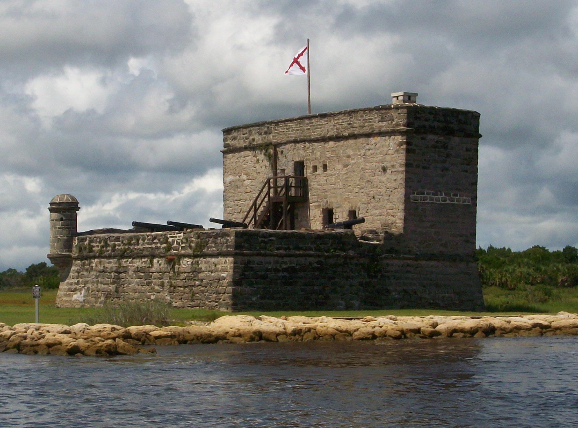
Fort Matanzas National Monument preserves the fortified coquina watchtower, completed in 1742, which defended the southern approach to the Spanish military settlement of St. Augustine. It also protect...

6 mi from route ~14 min detour Free near mile 424.2
Park Closure: Beach Access Ramp Closure
View on nps.gov
Castillo de San Marcos National Monument

Castillo de San Marcos National Monument

National Monument

Built by the Spanish in St. Augustine to defend Florida and the Atlantic trade route, Castillo de San Marcos National Monument preserves the oldest masonry fortification in the continental United Stat...

7 mi from route ~17 min detour $15 near mile 440.5
View on nps.gov
Canaveral National Seashore

Canaveral National Seashore

National Seashore

Discover a dynamic barrier island shaped by dunes, coastal hammocks, and Mosquito Lagoon. Walk among ancient Timucua shell mounds and connect with thousands of years of human history. Immerse yourself...

11 mi from route ~27 min detour $25 near mile 358.9
View on nps.gov
Biscayne National Park

Biscayne National Park

National Park

Within sight of Miami, yet worlds away, Biscayne protects a rare combination of aquamarine waters, emerald islands, and fish-bejeweled coral reefs. Evidence of 10,000 years of human history is here to...

15 mi from route ~38 min detour Free near mile 114.2
View on nps.gov
Everglades National Park

Everglades National Park

National Park

Established in 1947 as the first national park created for its biodiversity, Everglades National Park protects 1.5 million acres of wetland, forest, and marine habitats and the native plants and anima...

27 mi from route ~67 min detour $35 near mile 97.9
View on nps.gov

Park data from the National Park Service API. Alerts update every 2 hours.

Fuel & Cost

Regular Gas

$79.03 one way

$158.06 round trip

$4.24/gal 25.4 MPG avg 166 kg CO2
Fuel Type $/gal One Way Round Trip
midgrade $4.60 $85.61 $171.21
premium $4.90 $91.19 $182.39
diesel $5.64 $105.11 $210.21

Estimated Tolls: $10.17

Florida's Turnpike (104.7 mi) $7.33
Homestead Extension (47.4 mi) $2.84

Toll estimates based on average 2024-2025 rates. EZ-Pass/SunPass discounts may lower the actual cost.

Estimated Trip Cost (one way, 1 person)

Fuel

$79

Tolls

$10

Hotel (1n)

$80–$140

Meals

$50–$100

Total

$219–$329

Rough estimate based on US averages. Hotel $80–$140/night, meals $25–$50/day.

Estimated CO2 emission: 165.5 kg one way. Prices: EIA weekly data, 2026-04-06.

Driving Electric?

About $50 in charging · 1 stop · 67% less CO2

Vehicle Type kWh Stops DC Fast Home Charge
Average EV 141.9 1 $49.68 $22.71
Efficient EV 118.3 1 $41.40 $18.92
EV Truck/SUV 189.2 2 $66.23 $30.28

Gas CO2

166 kg

EV CO2

55 kg (67% less)

Plan for 1 charging stop. A 30-minute DC fast charge mid-route should be enough to complete the trip comfortably.

DC fast charging avg $0.35/kWh. Home charging avg $0.16/kWh. US grid CO2: 0.39 kg/kWh.

Travel Intel

Current conditions at both ends of the drive.

Forecast data refreshed 1 hour ago

Origin

Big Pine Key, FL

Morning in Big Pine Key on Monday

Local time

9:20 AM

EDT

Current temp

74°F

Unavailable

Live forecast

Destination

Jacksonville, FL

Morning in Jacksonville on Monday

Local time

9:20 AM

EDT

Current temp

82°F

Patchy Fog then Mostly Sunny

E 3 to 14 mph 0% chance Live forecast

Seasonal Notes

Summer travel usually means heavier construction, hotter rest stops, and busier weekend traffic around major cities.

Winter travel shortens daylight, so a route that looks manageable on paper can feel much longer after dark.

Holiday weekends tend to make both departure and arrival windows slower than the raw route time suggests.

For long drives, weather on day two can matter just as much as conditions at departure, so check the whole travel window rather than only the first day.

Time zone

Same local time

Origin and destination are on the same clock, so arrival timing is easier to judge at a glance.

Temperature spread

8 degrees warmer at arrival

A meaningful temperature swing is a good cue to rethink layers, water, and how soon you want to arrive.

Road read

9h 26m on the road

This is long enough that the arrival forecast matters almost as much as departure conditions. Recheck both ends before you roll.

Weather data from the National Weather Service. Conditions may change; check closer to your travel date.

Frequently Asked Questions

The drive from Big Pine Key, FL to Jacksonville, FL covers 473.1 miles and takes about 9h 26m without stops. Add 15-30 minutes for a fuel or rest stop on longer drives.
The main roads are I 95, Florida's Turnpike, New Seven Mile Bridge. Most of the drive stays on highways, so watch for ramps and exits.
Consider an overnight stop or starting very early.
Yes. This route is usually more comfortable as a 2-day drive. A sensible stopping point is after roughly 237 miles on day one.
The midpoint is about 236.5 miles from Big Pine Key, FL. Look for rest areas, gas stations, or food options near the halfway mark.
At current regular gas prices, expect to spend about $79.03 one way. This estimate uses 25.4 MPG — your actual cost will vary with your vehicle's fuel efficiency and current gas prices.
Start early — leave by 6-7 AM to arrive at a reasonable hour. This is a long drive — plan for a morning departure or consider splitting it into two days.
Plan about 2 meaningful breaks for fuel, food, or rest. Plan on a short reset every 3 to 4 hours to stay fresh behind the wheel.
This is a demanding drive. With 22 significant decision points across 473.1 miles, you will need to stay alert — especially through interchange areas and urban stretches. Consider splitting it into segments if you are not comfortable with fast highway navigation.
The main spots that need attention: at 96.8 miles: Exit ramp - move to the correct lane early. Lane positioning matters here. Multiple destination signs - pick the right one; at 143.5 miles (Homestead Extension of Florida's Turnpike): Highway fork - watch signs carefully. Lane positioning matters here. Multiple destination signs - pick the right one; at 249.3 miles: Exit ramp - move to the correct lane early. Lane positioning matters here. Multiple destination signs - pick the right one.
Between Big Pine Key, FL and Jacksonville, FL, road signs point toward Miami, Orlando, Florida's Turnpike North, Florida's Turnpike Toll North and Vero Beach.

Was this route helpful?

Thanks for your feedback!

Your tip has been submitted. Thanks!

/500

Explore More

Explore more options from Big Pine Key, FL or browse trips ending in Jacksonville, FL.

Looking for more statewide routes? Browse FL road trips.

Explore maps for Big Pine Key, FL or Jacksonville, FL on MapSof.net.