Trip from Boiling Springs, NC to Wilmington, NC

Drive Time

9h 10m

Distance

432.9 mi

697 km

Drive Score

8/10

Great drive

Same Day?

2-day trip

Fuel Cost

$72

one way

EV Charging

Excellent

20 DC fast

Best Time to Leave

Save up to 25 min
4 AM
9h 2m ★
6 AM
9h 11m
8 AM
9h 27m
10 AM
9h 16m
12 PM
9h 15m
3 PM
9h 17m
5 PM
9h 26m
8 PM
9h 6m

Estimated drive times based on typical traffic patterns. Actual times may vary with weather, construction, and real-time conditions.

Trip Overview

The drive from Boiling Springs, NC to Wilmington, NC covers 432.9 miles and takes about 9h 10m behind the wheel. It usually feels better as a 2-day road trip than as one long push.

The route leans on Andrew Jackson Highway, US 19, US 74 for much of the mileage, and the overall profile is turn-heavy local drive. The longest uninterrupted segment is about 104.8 miles on Andrew Jackson Highway. At current regular gas prices, budget about $72.00 one way before food or hotel costs.

Trip Pace

Best split across 2 days

Treat the return leg as its own travel day rather than an afterthought.

Break Rhythm

2 planned breaks

Plan on a short reset every 3 to 4 hours to stay fresh behind the wheel.

Midpoint

216.5 miles from Boiling Springs, NC

A natural place for your longest stop of the day , about 4h 44m into the drive .

Drive Character

Expect a 9h 10m drive with frequent turns across 432.9 miles of local and secondary roads.

This route has more turning and local-road decision points than a simple highway run.
There are about 57 navigation steps in the underlying route data, so the final approach matters more than the middle miles.
Andrew Jackson Highway is the longest continuous segment at about 104.8 miles.

How Hard Is This Drive?

Expect a hands-on drive with frequent turns and local roads rather than long highway stretches. This route has several spots where lane changes, forks, or exits need your full attention. The trickiest moment comes around 150.4 miles in near US 74 / Sgt W Dean Arledge Memorial Highway.

Route Complexity 10/10

High effort - long or complex enough to need steady focus all day

This is a demanding drive. With 29 significant decision points across 432.9 miles, you will need to stay alert — especially through interchange areas and urban stretches. Consider splitting it into segments if you are not comfortable with fast highway navigation.

Where does it get tricky?

The main spots that need attention: at 150.4 miles (US 74 / Sgt W Dean Arledge Memorial Highway): Exit ramp - move to the correct lane early. Lane positioning matters here. Multiple destination signs - pick the right one; at 205.1 miles: Highway fork - watch signs carefully. Lane positioning matters here. Multiple destination signs - pick the right one; at 232.1 miles: Exit ramp - move to the correct lane early. Lane positioning matters here. Multiple destination signs - pick the right one.

Critical Maneuvers

5 of 29 key points

These are the spots where you need to pay the most attention. Preview them before you drive.

8
150.4 mi into trip | ~3h 25m in | US 74 / Sgt W Dean Arledge Memorial Highway

Take the exit onto US 74 / Sgt W Dean Arledge Memorial Highway toward US 74 East, NC 108: Columbus, Rutherfordton

Exit ramp - move to the correct lane early. Lane positioning matters here. Multiple destination signs - pick the right one

Use the slight right lane. Exit 67 Toward US 74 East, NC 108: Columbus, Rutherford...
8
205.1 mi into trip | ~4h 31m in

Keep slight left at fork toward I 85 North: Gastonia, Charlotte

Highway fork - watch signs carefully. Lane positioning matters here. Multiple destination signs - pick the right one

Use the straight / slight right lanes. Toward I 85 North: Gastonia, Charlotte
8
232.1 mi into trip | ~5h 3m in

Take the exit toward NC 16: Brookshire Boulevard, Downtown Charlotte

Exit ramp - move to the correct lane early. Lane positioning matters here. Multiple destination signs - pick the right one

Use the slight right lane. Exit 36 Toward NC 16: Brookshire Boulevard, Downtown Ch...
9
232.3 mi into trip | ~5h 3m in

Keep slight right at fork toward NC 16 South: Downtown Charlotte, Brookshire Boulevard, Charlotte, Bank of America Stadium

Highway fork - watch signs carefully. Lane positioning matters here. Multiple destination signs - pick the right one

Use the left / right lanes. Toward NC 16 South: Downtown Charlotte, Brooksh...
9
249.1 mi into trip | ~5h 27m in | US 74 BYP / Monroe Expressway

Keep slight left at fork onto US 74 BYP / Monroe Expressway toward US 74 Toll Bypass East: Rockingham, Wilmington

Highway fork - watch signs carefully. Lane positioning matters here. Multiple destination signs - pick the right one

Use the straight / slight right lanes. Exit 255 Toward US 74 Toll Bypass East: Rockingham, Wilm...

Towns Along This Route

Between Boiling Springs, NC and Wilmington, NC, road signs point toward Spartanburg, Rutherfordton, Charlotte and Bank Of America Stadium.

Spartanburg

115.6 mi in | ~2h 43m | via US 74; US 64 Truck

Rutherfordton

150.4 mi in | ~3h 25m | via US 74

Charlotte

205.1 mi in | ~4h 31m

Bank Of America Stadium

232.3 mi in | ~5h 3m

Main Roads

Road Distance Duration
Andrew Jackson Highway 104.8 mi 2h 7m
US 19 75.2 mi 1h 36m
US 74 41.3 mi 51m
American Indian Highway 33.6 mi 36m
Monroe Expressway 18.7 mi 21m
Sgt W Dean Arledge Memorial Highway 18.2 mi 19m
Senator Marshall Arthur Rauch Highway 17.6 mi 21m
James A. Callahan Highway 15.2 mi 17m
Longest stretch: Andrew Jackson Highway — 104.8 mi, about 2h 7m

Turn-by-Turn Driving Directions

Step-by-step road directions between Boiling Springs, NC and Wilmington, NC.

1

Start on Boiling Springs Road

3.8 mi · 14 min · Boiling Springs Road
2

At end of road, turn left onto Hanging Dog Road

4.8 mi · 9 min · Hanging Dog Road
3

At end of road, turn left onto Joe Brown Highway

0.9 mi · 2 min · Joe Brown Highway
4

Turn slight right onto Texana Road

1.0 mi · 2 min · Texana Road
5

Turn right onto Joe Brown Highway

363 ft · 15 sec · Joe Brown Highway
6

Turn left onto Conaheeta Street

0.5 mi · 1 min · Conaheeta Street
7

At end of road, turn left onto US 19 Business

346 ft · 8 sec · Valley River Avenue
8

Continue on US 19 Business

438 ft · 10 sec · Wilson Street
9

Continue on US 19 Business

0.4 mi · 51 sec · Hill Street
10

Continue on US 19 Business

0.2 mi · 31 sec · Andrews Road
11

Turn right onto Bulldog Drive

0.3 mi · 43 sec · Bulldog Drive
12

At end of road, turn left onto US 19; US 74; US 129

23 mi · 30 min · US 19; US 74; US 129
13

Continue on US 19; US 74

9.9 mi · 12 min · US Highway 19
14

Turn left onto US 19; US 74

52 mi · 1 hr 5 min · US 19; US 74
Use the straight lane.
15

Keep slight right at fork onto US 74; US 64 Truck

18 mi · 23 min · US 74; US 64 Truck
Toward I 40 East: Asheville
16

Take the exit onto US 74; US 64 Truck

23 mi · 27 min · US 74; US 64 Truck
Toward I 26 East, US 74 East, US 64 Truck East: Hendersonville, Spartanburg
17

Keep slight left at fork onto I 26; US 74

12 mi · 14 min · Andrew Jackson Highway
18

Take the exit onto US 74

0.3 mi · 18 sec · Sgt W Dean Arledge Memorial Highway
Exit 67 Toward US 74 East, NC 108: Columbus, Rutherfordton Use the slight right lane.
19

Keep slight left at fork onto US 74

0.2 mi · 10 sec · Sergeant W Dean Arledge Memorial Highway
Toward US 74 East: Forest City, Rutherfordton
20

Continue on US 74

18 mi · 19 min · Sgt W Dean Arledge Memorial Highway
21

Continue on US 74

15 mi · 17 min · James A. Callahan Highway
22

Take the exit onto US 74

12 mi · 17 min · West Dixon Boulevard
Use the straight / right lanes.
23

Continue on US 74

1.8 mi · 2 min · Andrew Jackson Highway
24

Continue on US 74

6.8 mi · 7 min · Senator J. Ollie Harris Highway
Use the straight / slight right lanes.
25

Take the exit

0.1 mi · 7 sec
Toward I 85, US 29 South: Charlotte, Spartanburg
26

Keep slight left at fork

0.8 mi · 55 sec
Toward I 85 North: Gastonia, Charlotte Use the straight / slight right lanes.
27

Merge onto I 85

18 mi · 21 min · Senator Marshall Arthur Rauch Highway
Use the straight lane.
28

Continue on I 85

8.5 mi · 10 min · Cameron Morrison Bridge
Use the straight / slight right lanes.
29

Take the exit

0.2 mi · 26 sec
Exit 36 Toward NC 16: Brookshire Boulevard, Downtown Charlotte Use the slight right lane.
30

Keep slight right at fork

386 ft · 11 sec
Toward NC 16 South: Downtown Charlotte, Brookshire Boulevard, Charlotte, Bank of America Stadium Use the left / right lanes.
31

Merge onto NC 16

0.3 mi · 21 sec · Brookshire Boulevard
32

Continue on NC 16

3.6 mi · 5 min · Brookshire Freeway
Use the straight / slight right lanes.
33

Take the exit

0.4 mi · 55 sec
Exit 2B Toward US 74 East, NC 27 East: Independence Boulevard Use the slight left / straight lanes.
34

Merge onto US 74; NC 27

3.3 mi · 4 min · East Independence Expressway
Use the straight / right lanes.
35

Keep slight right at fork onto US 74

357 ft · 4 sec · East Independence Boulevard
Toward US 74 East
36

Continue on US 74

2.1 mi · 2 min · East Independence Expressway
Use the straight / right lanes.
37

Continue on US 74

2.4 mi · 3 min · East Independence Boulevard
Use the straight / right lanes.
38

Continue on US 74

4.5 mi · 6 min · Independence Boulevard
Use the straight lane.
39

Keep slight left at fork onto US 74 BYP

19 mi · 21 min · Monroe Expressway
Exit 255 Toward US 74 Toll Bypass East: Rockingham, Wilmington Use the straight / slight right lanes.
40

Merge onto US 74

0.3 mi · 27 sec · Carroll M. Edwards Highway
Use the straight lane.
41

Continue on US 74

2.9 mi · 5 min · West Marshville Boulevard
42

Continue on US 74

2.5 mi · 3 min · Carroll M. Edwards Highway
43

Continue on US 74

6.1 mi · 8 min · W. Cliff Martin Highway
Use the straight lane.
44

Keep slight right at fork onto US 74

6.7 mi · 9 min · W. Cliff Martin Highway
45

Continue on US 52; US 74; NC 742

0.7 mi · 1 min · Salisbury Street
46

Continue on US 52; US 74; NC 742

2.4 mi · 4 min · West Caswell Street
47

Continue on US 74

10 mi · 13 min · Andrew Jackson Highway
Use the straight lane.
48

Keep slight left at fork onto US 74

1.1 mi · 1 min · Andrew Jackson Highway
Toward US 74 East: Lumberton
49

Continue on US 74

15 mi · 16 min · G R Kindley Freeway
Use the straight / slight right lanes.
50

Continue on US 74

9.7 mi · 11 min · Andrew Jackson Highway
51

Keep slight right at fork onto US 74

10 mi · 10 min · Andrew Jackson Highway
Use the straight / slight right lanes.
52

Continue on US 74

34 mi · 36 min · American Indian Highway
53

Continue on US 74; NC 130

60 mi · 1 hr 13 min · Andrew Jackson Highway
Use the straight lane.
54

Continue on US 17; US 74; US 76

3.1 mi · 4 min · Ocean Highway East
55

Continue on US 17; US 76; US 421

0.8 mi · 1 min · Cape Fear Memorial Bridge
56

Turn left onto US 421; US 17 Business

0.1 mi · 15 sec · South 3rd Street
57

Arrive at destination

US 17 Business

Trip Plan

Morning Departure

Start early — leave by 6-7 AM to arrive at a reasonable hour.

Evening Departure

This is a long drive — plan for a morning departure or consider splitting it into two days.

This drive is better paced as a 2-day trip.
Plan roughly 2 meaningful breaks for fuel, food, and rest.
The halfway point lands around 216.5 miles from Boiling Springs, NC, or about 4h 44m into the drive.
The longest continuous stretch on this route runs about 104.8 miles.

Consider an overnight stop or starting very early.

Departure

Before you leave

Start with fuel, water, and navigation already sorted so the first hour feels easy.

First stop

Around 95 miles or 2h 17m in

Use this first pause for coffee, a restroom break, and a quick traffic check ahead.

Halfway reset

Around 216.5 miles or 4h 44m in

This is the best place for your longest stop, a real meal, and a full fuel check.

Overnight split

Day 1 wrap after about 216.5 miles or 4h 44m

Stop before fatigue turns the last few hours into a grind. You want day two to start fresh, not just resumed.

Final approach

Final hour starts around 7h 56m

Traffic, exits, and arrival timing usually matter more near Wilmington, NC than in the middle of the route.

Before You Leave

+

Open the route before leaving Boiling Springs, NC so your first major turns are already loaded.

+

Leave with enough water and a charging cable within reach, not packed away.

+

Check your fuel range against the first long segment, especially if you are starting outside city service areas.

+

Pick one backup stop option before the midpoint in case traffic changes your pacing.

+

Treat this as a 2-day road trip and book the overnight stop before the busiest arrival window.

Day 1

Settle into the route from Boiling Springs, NC

Aim for roughly 216 miles and 4.6 hours of wheel time on this day.

Day 2

Finish the approach into Wilmington, NC

Aim for roughly 216 miles and 4.6 hours of wheel time on this day.

Your first comfortable stop window is around 95 miles from Boiling Springs, NC.
This route usually feels better as a 2-day drive than as one long push.
Plan about 2 real breaks rather than only quick fuel stops.
The longest stretch is on Andrew Jackson Highway for about 104.8 miles.

Where to Stop

Rest stops, refuel points, and overnight suggestions along this route.

Halfway Point

Midpoint

About 216.5 mi from Boiling Springs, NC · 4h 44m into the drive

Downtown Inman Mills, SC, SC

Mid-route town

Overnight candidate

Inman Mills, SC

216 mi into the route

Best for: Hotel check-in, dinner, and a fresh start

This lines up well with a realistic day-end stop if you are breaking the drive into stages.

Find hotels in Inman Mills, SC

Overnight Options

Night 1

Inman Mills, SC

216 mi · about 4.6h in

A practical overnight split lands near Inman Mills, SC after about 216 miles or 4.6 hours of driving.

Find hotels

Pacing Suggestions

Knoxville, TN

Fuel and coffee

A short stop after about 99 miles helps settle the day before fatigue starts building.

Inman Mills, SC

Meal break

The midpoint is around 224.9 miles from Boiling Springs, NC, which is a good place for a longer meal and fuel stop.

Arriving in Wilmington, NC

The final approach into Wilmington, NC usually feels slower than the middle of the drive, so avoid planning your tightest schedule at the very end.

Try to arrive with enough fuel left to skip an immediate station stop unless you already know the area around Wilmington, NC.

On a multi-day trip, keep the last day a little lighter so you reach Wilmington, NC with some flexibility left in the schedule.

After long uninterrupted mileage, take five minutes before the last urban segment to reset and refocus on exits, merges, and city traffic.

These stop ideas are pacing suggestions — the exact town or exit can change with traffic, hotel plans, and fuel range.

National Parks Near This Route

Worth a detour if your schedule allows.

Moores Creek National Battlefield

Moores Creek National Battlefield

National Battlefield

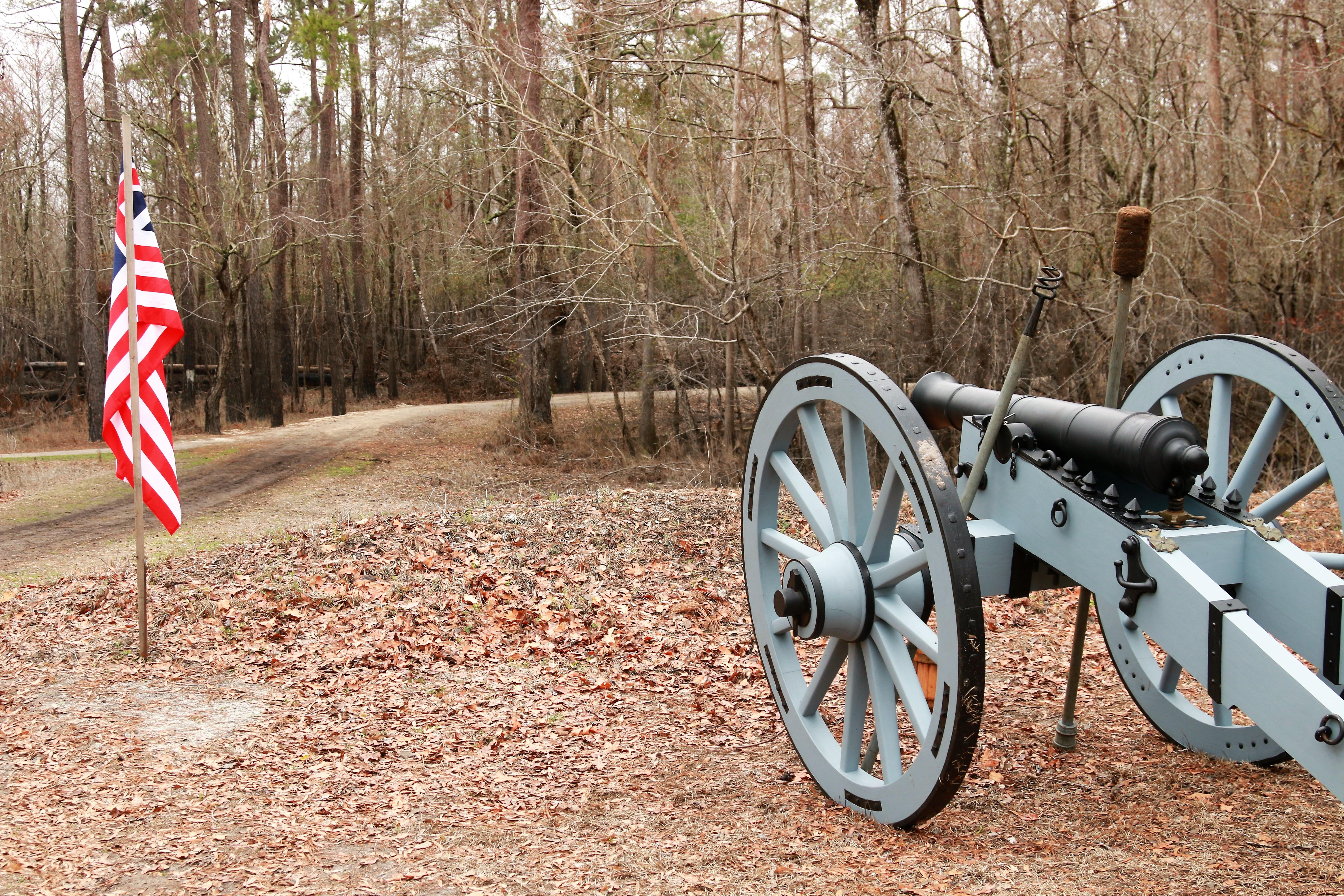
In the early morning hours of February 27, 1776, Loyalist forces charged across a partially dismantled Moores Creek Bridge. Beyond the bridge, nearly 1,000 North Carolina Patriots waited quietly with...

12 mi from route ~29 min detour Free near mile 418
View on nps.gov
Great Smoky Mountains National Park

Great Smoky Mountains National Park

National Park

Ridge upon ridge of forest straddles the border between North Carolina and Tennessee in Great Smoky Mountains National Park. World renowned for its diversity of plant and animal life, the beauty of it...

13 mi from route ~33 min detour Free near mile 59.7
View on nps.gov

Park data from the National Park Service API. Alerts update every 2 hours.

Fuel & Cost

Regular Gas

$72.00 one way

$144.00 round trip

$4.07/gal 25.4 MPG avg 157 kg CO2
Fuel Type $/gal One Way Round Trip
midgrade $4.43 $78.45 $156.90
premium $4.78 $84.63 $169.26
diesel $5.64 $99.95 $199.90

No toll roads detected on this route.

Estimated Trip Cost (one way, 1 person)

Fuel

$72

Hotel (1n)

$80–$140

Meals

$50–$100

Total

$202–$312

Rough estimate based on US averages. Hotel $80–$140/night, meals $25–$50/day.

Estimated CO2 emission: 157.4 kg one way. Prices: EIA weekly data, 2026-04-06.

EV Charging Along Route

20 DC fast chargers · Coverage: excellent

Westgate Shopping Center - Tesla Supercharger

Asheville, NC

Tesla

20 DCFC

Asheville Outlets - Tesla Supercharger

Asheville, NC

Tesla

12 DCFC

Biltmore Park Town Square - Tesla Supercharger

Asheville, NC

Tesla

12 DCFC

Hendersonville, NC - Tesla Supercharger

Hendersonville, NC

Tesla

12 DCFC

Sylva, NC - Tesla Supercharger

Sylva, NC

Tesla

8 DCFC

Forest Ridge Shopping Center (Asheville, NC)

Asheville, NC

Electrify America

8 DCFC

Whittier, NC

Whittier, NC

RIVIAN_ADVENTURE

6 DCFC

Asheville, NC

Asheville, NC

RIVIAN_ADVENTURE

6 DCFC

ChargePoint Network: 7 Tesla: 5 EV Connect: 2 RIVIAN_ADVENTURE: 2 Electrify America: 2 eVgo Network: 1 Blink Network: 1

Station data from NREL Alternative Fuel Stations database.

Driving Electric?

About $45 in charging · 1 stop · 66% less CO2

Vehicle Type kWh Stops DC Fast Home Charge
Average EV 129.9 1 $45.45 $20.78
Efficient EV 108.2 1 $37.88 $17.32
EV Truck/SUV 173.2 2 $60.61 $27.71

Gas CO2

151 kg

EV CO2

51 kg (66% less)

Plan for 1 charging stop. A 30-minute DC fast charge mid-route should be enough to complete the trip comfortably.

DC fast charging avg $0.35/kWh. Home charging avg $0.16/kWh. US grid CO2: 0.39 kg/kWh.

Travel Intel

Current conditions at both ends of the drive.

Forecast data refreshed 3 days ago

Origin

Boiling Springs, NC

Morning in Boiling Springs on Monday

Local time

11:59 AM

EDT

Current temp

58°F

Unavailable

Live forecast

Destination

Wilmington, NC

Morning in Wilmington on Monday

Local time

11:59 AM

EDT

Current temp

64°F

Unavailable

Live forecast

Seasonal Notes

Summer travel usually means heavier construction, hotter rest stops, and busier weekend traffic around major cities.

Winter travel shortens daylight, so a route that looks manageable on paper can feel much longer after dark.

Holiday weekends tend to make both departure and arrival windows slower than the raw route time suggests.

For long drives, weather on day two can matter just as much as conditions at departure, so check the whole travel window rather than only the first day.

Time zone

Same local time

Origin and destination are on the same clock, so arrival timing is easier to judge at a glance.

Temperature spread

6 degrees warmer at arrival

A meaningful temperature swing is a good cue to rethink layers, water, and how soon you want to arrive.

Road read

9h 10m on the road

This is long enough that the arrival forecast matters almost as much as departure conditions. Recheck both ends before you roll.

Weather data from the National Weather Service. Conditions may change; check closer to your travel date.

Frequently Asked Questions

The drive from Boiling Springs, NC to Wilmington, NC covers 432.9 miles and takes about 9h 10m without stops. Add 15-30 minutes for a fuel or rest stop on longer drives.
The main roads are Andrew Jackson Highway, US 19, US 74. Expect a mix of highway and local road driving.
Consider an overnight stop or starting very early.
Yes. This route is usually more comfortable as a 2-day drive. A sensible stopping point is after roughly 216 miles on day one.
The midpoint is about 216.5 miles from Boiling Springs, NC. Look for rest areas, gas stations, or food options near the halfway mark.
At current regular gas prices, expect to spend about $69.28 one way. This estimate uses 25.4 MPG — your actual cost will vary with your vehicle's fuel efficiency and current gas prices.
Start early — leave by 6-7 AM to arrive at a reasonable hour. This is a long drive — plan for a morning departure or consider splitting it into two days.
Plan about 2 meaningful breaks for fuel, food, or rest. Plan on a short reset every 3 to 4 hours to stay fresh behind the wheel.
This is a demanding drive. With 29 significant decision points across 432.9 miles, you will need to stay alert — especially through interchange areas and urban stretches. Consider splitting it into segments if you are not comfortable with fast highway navigation.
The main spots that need attention: at 150.4 miles (US 74 / Sgt W Dean Arledge Memorial Highway): Exit ramp - move to the correct lane early. Lane positioning matters here. Multiple destination signs - pick the right one; at 205.1 miles: Highway fork - watch signs carefully. Lane positioning matters here. Multiple destination signs - pick the right one; at 232.1 miles: Exit ramp - move to the correct lane early. Lane positioning matters here. Multiple destination signs - pick the right one.
Between Boiling Springs, NC and Wilmington, NC, road signs point toward Spartanburg, Rutherfordton, Charlotte and Bank Of America Stadium.

Was this route helpful?

Thanks for your feedback!

Your tip has been submitted. Thanks!

/500

Explore More

Explore more options from Boiling Springs, NC or browse trips ending in Wilmington, NC.

Looking for more statewide routes? Browse NC road trips.

Explore maps for Boiling Springs, NC or Wilmington, NC on MapSof.net.