Brookhaven, NY to Charlotte, NY is 385.1 miles and takes about 8h 15m via I 81, Christopher Columbus Highway, and Long Island Expressway, with a fuel budget near $63 and enough daylight to finish in a day if you start early. This trip stays within the Northeast region, primarily within New York State. It's a route that balances interstate travel with more local road sections. Consider this trip if you're looking for a drive that offers a bit of variety without being overly demanding, making it a good candidate for a single, focused travel day.
Trip Pace
Best split across 2 days
Treat the return leg as its own travel day rather than an afterthought.
Break Rhythm
2 planned breaks
Plan on a short reset every 3 to 4 hours to stay fresh behind the wheel.
Midpoint
192.5 miles from Brookhaven, NY
A natural place for your longest stop of the day
, about 4h 4m into the drive
.
Brookhaven is the largest town in Suffolk County, part of Long Island, New York. With 485,000 residents (2020). It includes a patchwork of villages and other communities, and is the only town on the island to touch both the Long Island Sound and Atlantic Ocean. The villages of Belle Terre, Bellport, Lake Grove, Mastic Beach, Old Field, Patchogue, Poquott, Port Jefferson, and Shoreham are semi-autonomous, and provide their own services in addition to those provided by the town. Other prominent communities include Mount Sinai, Stony Brook, and Fire Island, a long and car-free resort island off the south coast of the town.
Top landmarks
•Wardenclyffe Tower — early experimental wireless transmission station designed and built by Nikola Te...
•West Meadow Beach Historic District — historic district in the United States
Turn-heavy local drive route profile with national parks nearby.
Drive Character
This route is characterized by its turn-heavy local drive profile, with 53% on highways. You'll experience a mix of faster-paced interstate travel, particularly on I 81, which features the longest uninterrupted stretch of 97.3 miles. As you progress, expect the roads to become more engaging with frequent turns and changes in speed, moving away from a pure highway experience. This dynamic offers a more varied driving sensation than a constant interstate cruise.
This route has more turning and local-road decision points than a simple highway run.
There are about 68 navigation steps in the underlying route data, so the final approach matters more than the middle miles.
I 81 is the longest continuous segment at about 97.3 miles.
How Hard Is This Drive?
Expect a hands-on drive with frequent turns and local roads rather than long highway stretches. This route has several spots where lane changes, forks, or exits need your full attention. The trickiest moment comes around 47.3 miles in.
Driving Effort10/10
High effort - long or complex enough to need steady focus all day
Balances navigation complexity with total wheel time.
This is a demanding drive. With 47 significant decision points across 385.1 miles, you will need to stay alert - especially through interchange areas and urban stretches. Consider splitting it into segments if you are not comfortable with fast highway navigation.
Where does it get tricky?
The main spots that need attention: at 47.3 miles: Exit ramp - move to the correct lane early. Lane positioning matters here. Multiple destination signs - pick the right one; at 47.5 miles: Highway fork - watch signs carefully. Lane positioning matters here. Multiple destination signs - pick the right one; at 50.9 miles: Exit ramp - move to the correct lane early. Lane positioning matters here. Multiple destination signs - pick the right one.
Critical Maneuvers
5 of 47 key points
These are the spots where you need to pay the most attention. Preview them before you drive.
8
47.3 mi into trip|~1h 4m in
Take the exit toward Cross Island Parkway, Whitestone Bridge, Kennedy Airport
Exit ramp - move to the correct lane early. Lane positioning matters here. Multiple destination signs - pick the right one
Use the straight / slight right lanes.
Exit 31N-S
Toward Cross Island Parkway, Whitestone Bridge,...
10
47.5 mi into trip|~1h 5m in
Keep slight right at fork toward Cross Island Parkway North, Whitestone Bridge
Highway fork - watch signs carefully. Lane positioning matters here. Multiple destination signs - pick the right one
Use the slight left / slight right lanes.
Exit 31N
Toward Cross Island Parkway North, Whitestone B...
8
50.9 mi into trip|~1h 10m in
Take the exit toward I 295 North: Throgs Neck Bridge, Bronx, New England
Exit ramp - move to the correct lane early. Lane positioning matters here. Multiple destination signs - pick the right one
Use the straight / slight right lanes.
Exit 33
Toward I 295 North: Throgs Neck Bridge, Bronx,...
8
63.1 mi into trip|~1h 28m in
Take the exit toward I 95 South, NJTP South: Hackensack
Exit ramp - move to the correct lane early. Lane positioning matters here. Multiple destination signs - pick the right one
Use the straight / slight right lanes.
Toward I 95 South, NJTP South: Hackensack
8
63.3 mi into trip|~1h 28m in
Keep slight left at fork toward I 95 South, NJTP South: Hackensack
Highway fork - watch signs carefully. Lane positioning matters here. Multiple destination signs - pick the right one
Use the slight left / slight right lanes.
Toward I 95 South, NJTP South: Hackensack
Towns Mentioned on Route Signs
Based on OSRM destination-sign hints, not a full list of every settlement the road passes.
Between Brookhaven, NY and Charlotte, NY, road signs point toward Kennedy Airport, Cross Island Parkway North, Bronx, New England, Upper Level and Njtp South: Hackensack - among others.
Kennedy Airport
47.3 mi in|~1h 4m
Cross Island Parkway North
47.5 mi in|~1h 5m
Bronx
50.9 mi in|~1h 10m
New England
50.9 mi in|~1h 10m
Upper Level
60.6 mi in|~1h 24m|via I 95; US 1
Njtp South: Hackensack
63.1 mi in|~1h 28m
Hackensack
65.7 mi in|~1h 32m
Albany
238.4 mi in|~4h 58m|via I 81
Main Roads
Road
Distance
Duration
I 81
97.3 mi
1h 55m
Christopher Columbus Highway
68.2 mi
1h 20m
Long Island Expressway
41.4 mi
55m
New York State Thruway
30.3 mi
34m
I 380
27.7 mi
30m
Keystone Shortway
17.3 mi
24m
Eastern Expressway
10.8 mi
13m
Clinton Street
10.5 mi
15m
Longest stretch:
I 81
— 97.3 mi, about 1h 55m
Turn-by-Turn Driving Directions
Step-by-step road directions between Brookhaven, NY and Charlotte, NY.
1
Start on CR 36
0.4 mi·46 sec·South Country Road
2
Continue on South Country Road
354 ft·16 sec·South Country Road
3
Turn straight onto CR 80
0.8 mi·1 min·Montauk Highway
4
Turn left onto CR 16
4.2 mi·6 min·Horseblock Road
Use the left lane.
5
Turn left onto Express Drive North
0.2 mi·14 sec·Express Drive North
Use the left lane.
6
Take the ramp
0.2 mi·21 sec
Toward I 495 WEST: New York
7
Merge onto I 495
41 mi·55 min·Long Island Expressway
Use the straight / slight right lanes.
8
Take the exit
0.2 mi·27 sec
Exit 31N-SToward Cross Island Parkway, Whitestone Bridge, Kennedy AirportUse the straight / slight right lanes.
9
Keep slight right at fork
0.3 mi·38 sec
Exit 31NToward Cross Island Parkway North, Whitestone BridgeUse the slight left / slight right lanes.
10
Merge onto CI
3.1 mi·4 min·Cross Island Parkway
Use the straight / slight right lanes.
11
Take the exit
0.6 mi·1 min
Exit 33Toward I 295 North: Throgs Neck Bridge, Bronx, New EnglandUse the straight / slight right lanes.
12
Merge onto I 295
1.8 mi·3 min·Throgs Neck Bridge
13
Continue on I 295
0.7 mi·1 min·Throgs Neck Expressway
Use the straight / slight right lanes.
14
Keep slight left at fork onto I 295
6.6 mi·8 min·Cross Bronx Expressway
Use the straight / slight right lanes.
15
Keep slight left at fork onto I 95; US 1
0.7 mi·1 min·Trans-Manhattan Expressway
Toward Upper Level
16
Continue on I 95; US 1
0.6 mi·59 sec·George Washington Bridge (upper level)
17
Continue on I 95 EXPR; US 1 EXPR; US 9 EXPR
0.5 mi·48 sec·I 95 EXPR; US 1 EXPR; US 9 EXPR
18
Keep slight left at fork onto I 95 EXPR; US 1 EXPR; US 9 EXPR
0.6 mi·39 sec·I 95 EXPR; US 1 EXPR; US 9 EXPR
Use the straight / slight right lanes.
19
Keep slight left at fork onto I 95 EXPR; NJTP
0.1 mi·8 sec·I 95 EXPR; NJTP
20
Take the exit
0.2 mi·22 sec
Toward I 95 South, NJTP South: HackensackUse the straight / slight right lanes.
21
Keep slight left at fork
0.4 mi·29 sec
Toward I 95 South, NJTP South: HackensackUse the slight left / slight right lanes.
22
Merge onto I 95; NJTP
2.0 mi·2 min·New Jersey Turnpike
Use the straight / slight right lanes.
23
Take the exit
0.8 mi·1 min
Exit 69Toward I 80 West: Paterson, HackensackUse the straight / slight right lanes.
24
Continue on I 80
68 mi·1 hr 20 min·Christopher Columbus Highway
Use the straight / slight right lanes.
25
Keep slight left at fork onto I 80
5.5 mi·8 min·Keystone Shortway
Use the straight / slight right lanes.
26
Keep slight left at fork onto I 80
12 mi·15 min·Keystone Shortway
27
Take the exit
0.7 mi·46 sec
Exit 293Toward I 380 North: Scranton
28
Continue on I 380
28 mi·30 min·I 380
Use the straight lane.
29
Merge onto I 81
58 mi·1 hr 9 min·I 81
Use the straight lane.
30
Keep slight right at fork onto I 81
1.8 mi·2 min·I 81
Toward I 81 North: Syracuse, Albany
31
Keep slight left at fork onto I 81
37 mi·43 min·I 81
Toward I 81 North: Syracuse
32
Take the exit
0.1 mi·21 sec
Exit 52Toward NY 13: Cortland
33
Turn right onto NY 13
39 ft·5 sec·Clinton Avenue
34
Turn left onto Locust Avenue
1.2 mi·2 min·Locust Avenue
35
Continue on Albany Street
0.6 mi·1 min·Albany Street
36
At end of road, turn right onto US 11; NY 41
0.4 mi·1 min·South Main Street
37
Turn left onto NY 41
10 mi·15 min·Clinton Street
38
Continue on NY 41
0.5 mi·49 sec·East Lake Road
39
Continue on NY 41
4.8 mi·7 min·State Route 41
40
Continue on NY 41
9.4 mi·13 min·East Lake Road
41
Continue on NY 41
0.5 mi·48 sec·East Lake Street
42
Turn left onto US 20
7.3 mi·13 min·East Genesee Street
43
Turn right onto US 20
0.2 mi·12 sec·North Fulton Street
44
Turn left onto US 20; NY 5
0.4 mi·1 min·Arterial West
45
Continue on US 20; NY 5; NY 38
9.8 mi·11 min·Chase Street
Use the left lane.
46
Continue on US 20; NY 5
1.9 mi·2 min·Auburn Road
47
Turn right onto NY 318
4.1 mi·7 min·NY 318
48
Continue on NY 318
319 ft·10 sec·NY 318
Use the right lane.
49
Turn right onto NY 414
0.3 mi·28 sec·State Route 414
Use the right lane.
50
Continue on NY 414
217 ft·11 sec·Ridge Road
Use the left lane.
51
Take the ramp
0.2 mi·23 sec
Use the left lane.
52
Keep slight left at fork
0.6 mi·1 min
Toward I 90 West: BuffaloUse the straight / right lanes.
53
Merge onto I 90
30 mi·34 min·New York State Thruway
54
Take the exit
0.4 mi·51 sec
Exit 45Toward I 490: RochesterUse the slight right lane.
55
Continue on I 490
11 mi·13 min·Eastern Expressway
Use the straight / slight right lanes.
56
Take the exit
0.2 mi·13 sec
Exit 21Toward I 590 South, NY 590 NorthUse the slight right lane.
57
Keep slight right at fork
0.2 mi·18 sec
Toward NY 590 North: IrondequoitUse the slight right lane.
58
Merge onto NY 590
3.5 mi·4 min·Outer Loop
Use the straight / right lanes.
59
Take the exit
0.5 mi·55 sec
Exit 10AToward NY 104 West: GreeceUse the slight right lane.
60
Merge onto NY 104
3.5 mi·4 min·Keeler Street Expressway
Use the straight / slight right lanes.
61
Continue on NY 104
0.2 mi·12 sec·Veterans Memorial Bridge
62
Continue on NY 104
0.4 mi·25 sec·West Ridge Road
63
Turn right onto Lake Avenue
4.1 mi·6 min·Lake Avenue
64
Turn left onto Latta Road
0.2 mi·29 sec·Latta Road
65
Turn right onto Spanish Trail
0.2 mi·45 sec·Spanish Trail
66
Turn right
125 ft·14 sec
67
Turn left
72 ft·5 sec
68
Arrive at destination
Trip Plan
For this 8h 15m drive, departing Brookhaven, NY early in the morning is advisable to maximize daylight and allow for your recommended 2 stops. The longest stretch without a significant break is 97.3 miles on I 81, so plan your refueling and rest stops accordingly. Given the 'turn-heavy local drive' profile, be prepared for more frequent adjustments and potentially varied speed limits, especially outside of the main highway segments. Budgeting around $63 for fuel should cover the 385.1-mile journey.
Morning Departure
Start early — leave by 6-7 AM to arrive at a reasonable hour.
Evening Departure
This is a long drive — plan for a morning departure or consider splitting it into two days.
This drive is better paced as a 2-day trip.
Plan roughly 2 meaningful breaks for fuel, food, and rest.
The halfway point lands around 192.5 miles from Brookhaven, NY, or about 4h 4m into the drive.
The longest continuous stretch on this route runs about 97.3 miles.
Consider an overnight stop or starting very early.
Departure
Before you leave
Start with fuel, water, and navigation already sorted so the first hour feels easy.
First stop
Around 85 miles or 1h 55m in
Use this first pause for coffee, a restroom break, and a quick traffic check ahead.
Halfway reset
Around 192.5 miles or 4h 4m in
This is the best place for your longest stop, a real meal, and a full fuel check.
Overnight split
Day 1 wrap after about 192.5 miles or 4h 4m
Stop before fatigue turns the last few hours into a grind. You want day two to start fresh, not just resumed.
Final approach
Final hour starts around 6h 56m
Traffic, exits, and arrival timing usually matter more near Charlotte, NY than in the middle of the route.
Before You Leave
+
Open the route before leaving Brookhaven, NY so your first major turns are already loaded.
+
Leave with enough water and a charging cable within reach, not packed away.
+
Check your fuel range against the first long segment, especially if you are starting outside city service areas.
+
Pick one backup stop option before the midpoint in case traffic changes your pacing.
+
Treat this as a 2-day road trip and book the overnight stop before the busiest arrival window.
Day 1
Settle into the route from Brookhaven, NY
Aim for roughly 193 miles and 4.1 hours of wheel time on this day.
Day 2
Finish the approach into Charlotte, NY
Aim for roughly 193 miles and 4.1 hours of wheel time on this day.
Your first comfortable stop window is around 85 miles from Brookhaven, NY.
This route usually feels better as a 2-day drive than as one long push.
Plan about 2 real breaks rather than only quick fuel stops.
The longest stretch is on I 81 for about 97.3 miles.
Where to Stop
Rest stops, refuel points, and overnight suggestions along this route.
Halfway Point
Midpoint
About 192.5 mi from Brookhaven, NY
· 4h 4m into the drive
Place data sourced from public business listings. Hours and availability may vary.
National Parks Near This Route
Worth a detour if your schedule allows.
General Grant National Memorial
National Memorial
The final resting place of President Ulysses S. Grant and his wife, Julia, is the largest mausoleum in North America. It testifies to a people’s gratitude for the man who ended the bloodiest conflict...
5 mi from route
~11 min detour
Free
near mile 66.4
Caution: Lower Crypt Access Subject to Safe Conditions
Merchant’s clerk, Revolutionary War soldier, first Secretary Treasury of the United States: Alexander Hamilton’s life is memorialized at The Grange, the home he built on a country estate in uptown Man...
5 mi from route
~12 min detour
Free
near mile 66.4
Harriet Tubman was guided by a deep faith and devotion to family, freedom, and community. After emancipating herself and members of her family, she moved them from Ontario, Canada to Fleming and Aubur...
5 mi from route
~13 min detour
Free
near mile 318.7
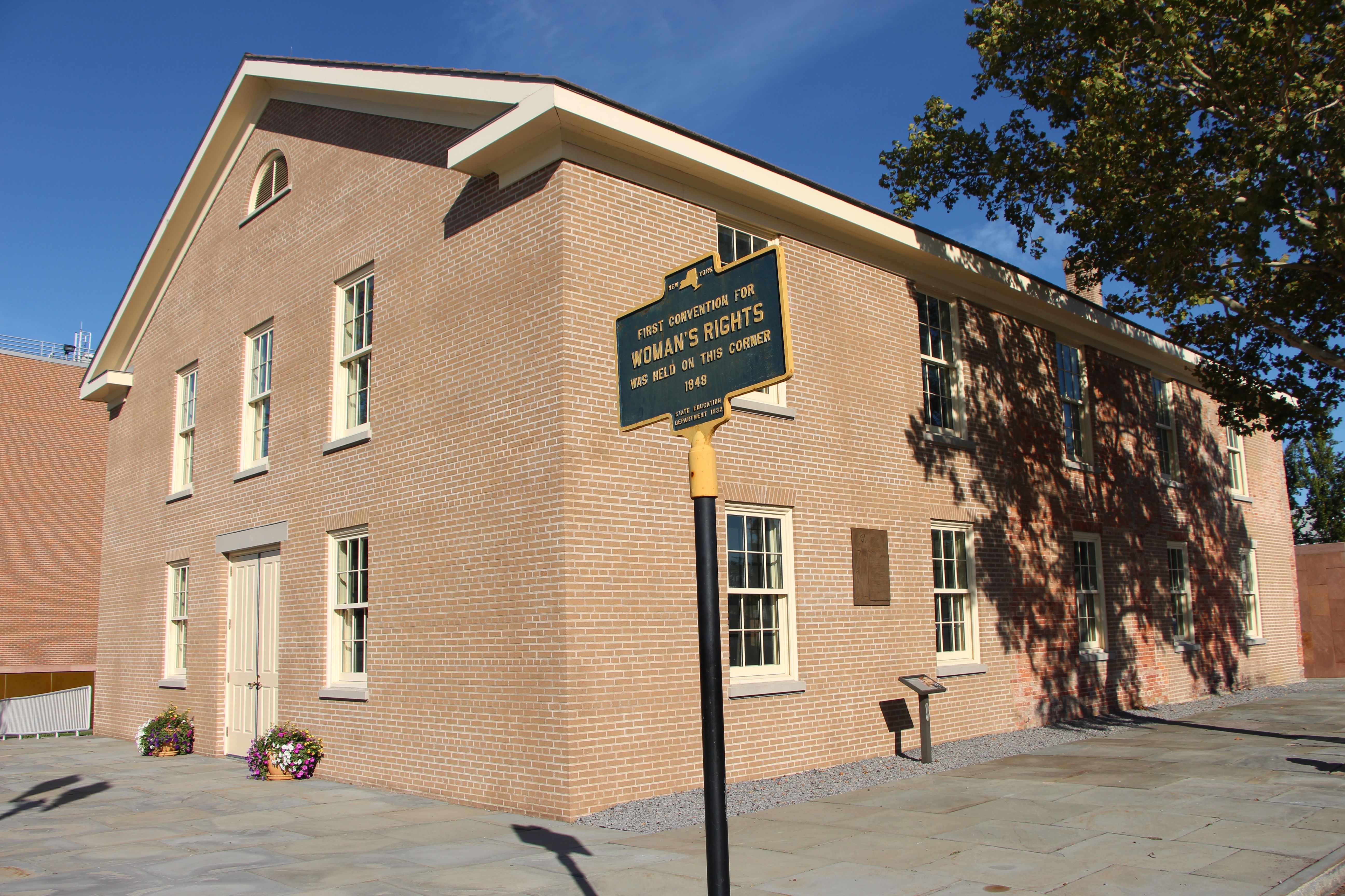
Women’s Rights National Historical Park tells the story of the first Women’s Rights Convention, held in Seneca Falls, New York on July 19-20, 1848. It is a story of struggles for civil rights, human r...
5 mi from route
~13 min detour
Free
near mile 331.9
Immerse yourself in an enchanting collage of coastal life and history. Rhythmic waves, high dunes, ancient maritime forests, historic landmarks and glimpses of wildlife, Fire Island has been a special...
Before the 1960s, almost everything about living authentically as a lesbian, a bisexual person or a gay man was illegal. The Stonewall Uprising on June 28, 1969 is a milestone in the quest for civil r...
9 mi from route
~23 min detour
Free
near mile 66.4
Station data from NREL Alternative Fuel Stations database.
Driving Electric?
About $40 in charging
· 1 stop
· 67% less CO2
Vehicle Type
kWh
Stops
DC Fast
Home Charge
Average EV
115.5
1
$40.44
$18.48
Efficient EV
96.3
1
$33.70
$15.40
EV Truck/SUV
154
1
$53.91
$24.65
Gas CO2
135 kg
EV CO2
45 kg (67% less)
Plan for 1 charging stop. A 30-minute DC fast charge mid-route should be enough to complete the trip comfortably.
DC fast charging avg $0.35/kWh. Home charging avg $0.16/kWh. US grid CO2: 0.39 kg/kWh.
Travel Intel
Current conditions at both ends of the drive.
Forecast as of Apr 18, 2026
Origin
Brookhaven, NY
Morning
in Brookhaven on Saturday
Local time
11:15 AM
EDT
Current temp
57°F
Partly Sunny
E 3 to 9 mph0% chanceLive forecast
Wind Advisory
Wind Advisory issued April 18 at 2:37AM EDT until April 19 at 12:00AM EDT by NWS Burlington VT
Destination
Charlotte, NY
Morning
in Charlotte on Saturday
Local time
11:15 AM
EDT
Current temp
58°F
Unavailable
Live forecast
57°F
Ramapo, NY
193 mi in
Seasonal Notes
Summer travel usually means heavier construction, hotter rest stops, and busier weekend traffic around major cities.
Winter travel shortens daylight, so a route that looks manageable on paper can feel much longer after dark.
Holiday weekends tend to make both departure and arrival windows slower than the raw route time suggests.
For long drives, weather on day two can matter just as much as conditions at departure, so check the whole travel window rather than only the first day.
Time zone
Same local time
Origin and destination are on the same clock, so arrival timing is easier to judge at a glance.
Temperature spread
1 degrees warmer at arrival
A meaningful temperature swing is a good cue to rethink layers, water, and how soon you want to arrive.
Road read
8h 15m on the road
This is long enough that the arrival forecast matters almost as much as departure conditions. Recheck both ends before you roll.
Weather data from the National Weather Service. Conditions may change; check closer to your travel date.
Frequently Asked Questions
The drive from Brookhaven, NY to Charlotte, NY covers 385.1 miles and takes about 8h 15m without stops. Add 15-30 minutes for a fuel or rest stop on longer drives.
The main roads are I 81, Christopher Columbus Highway, Long Island Expressway. Expect a mix of highway and local road driving.
Consider an overnight stop or starting very early.
Yes. This route is usually more comfortable as a 2-day drive. A sensible stopping point is after roughly 193 miles on day one.
The midpoint is about 192.5 miles from Brookhaven, NY. Look for rest areas, gas stations, or food options near the halfway mark.
At current regular gas prices, expect to spend about $63.39 one way. This estimate uses 25.4 MPG — your actual cost will vary with your vehicle's fuel efficiency and current gas prices.
Start early — leave by 6-7 AM to arrive at a reasonable hour. This is a long drive — plan for a morning departure or consider splitting it into two days.
Plan about 2 meaningful breaks for fuel, food, or rest. Plan on a short reset every 3 to 4 hours to stay fresh behind the wheel.
This is a demanding drive. With 47 significant decision points across 385.1 miles, you will need to stay alert - especially through interchange areas and urban stretches. Consider splitting it into segments if you are not comfortable with fast highway navigation.
The main spots that need attention: at 47.3 miles: Exit ramp - move to the correct lane early. Lane positioning matters here. Multiple destination signs - pick the right one; at 47.5 miles: Highway fork - watch signs carefully. Lane positioning matters here. Multiple destination signs - pick the right one; at 50.9 miles: Exit ramp - move to the correct lane early. Lane positioning matters here. Multiple destination signs - pick the right one.
Between Brookhaven, NY and Charlotte, NY, road signs point toward Kennedy Airport, Cross Island Parkway North, Bronx, New England, Upper Level and Njtp South: Hackensack - among others.
Yes. Nearby national parks include General Grant National Memorial, Hamilton Grange National Memorial and Harriet Tubman National Historical Park. There are 6 parks within detour distance of this route.
How this page is built
Compiled by the Trip.ovh planning team at COD Solutions Oy from open government datasets — OSRM over OpenStreetMap for geometry, EIA for fuel prices, NREL for EV charging, and NPS for national parks. See our methodology for refresh cadence and limitations.