
Trip from Caliente, NV to Sparks, NV

Last recalculated Apr 16, 2026

Drive Time

8h 48m

Distance

449.7 mi

724 km

Drive Score

7/10

Good drive

Same Day?

2-day trip

Fuel Cost

$90

one way

EV Charging

Unknown

Best Time to Leave

Save up to 24 min
4 AM
8h 40m ★
6 AM
8h 48m
8 AM
9h 4m
10 AM
8h 54m
12 PM
8h 52m
3 PM
8h 55m
5 PM
9h 3m
8 PM
8h 44m

Estimated drive times based on typical traffic patterns. Actual times may vary with weather, construction, and real-time conditions.

city in Lincoln County, Nevada, United States

Caliente, NV

Wikimedia Commons

Downtown Sparks, NV, NV

Sparks, NV

Wikimedia Commons

Trip Overview

The drive from Caliente, NV to Sparks, NV covers 449.7 miles and takes about 8h 48m behind the wheel. It usually feels better as a 2-day road trip than as one long push.

The route leans on Lincoln Highway, Great Basin Highway, Austin Highway for much of the mileage, and the overall profile is turn-heavy local drive. The longest uninterrupted segment is about 167.9 miles on Lincoln Highway. At current regular gas prices, budget about $89.59 one way before food or hotel costs.

Trip Pace

Best split across 2 days

Treat the return leg as its own travel day rather than an afterthought.

Break Rhythm

2 planned breaks

Plan on a short reset every 3 to 4 hours to stay fresh behind the wheel.

Midpoint

224.9 miles from Caliente, NV

A natural place for your longest stop of the day , about 4h 27m into the drive .

Who Is This Route For?

Solo Traveler

8h 48m drive, plan rest stops for pacing.

Scenic Drive

Turn-heavy local drive route profile.

Drive Character

Expect a 8h 48m drive with frequent turns across 449.7 miles of local and secondary roads.

This route has more turning and local-road decision points than a simple highway run.
There are about 30 navigation steps in the underlying route data, so the final approach matters more than the middle miles.
Lincoln Highway is the longest continuous segment at about 167.9 miles.

How Hard Is This Drive?

Expect a hands-on drive with frequent turns and local roads rather than long highway stretches. This route has several spots where lane changes, forks, or exits need your full attention. The trickiest moment comes early in the drive near US 93 / Front Street.

Driving Effort 7/10

Demanding - plan breaks and stay ahead of the key maneuvers

Balances navigation complexity with total wheel time.

This is a demanding drive. With 12 significant decision points across 449.7 miles, you will need to stay alert - especially through interchange areas and urban stretches. Consider splitting it into segments if you are not comfortable with fast highway navigation.

Where does it get tricky?

The main spots that need attention: near the start (US 93 / Front Street): Navigation decision point; at 105.4 miles (US 6; US 50; US 93 / Great Basin Highway): Navigation decision point; at 132.3 miles (US 50 / Aultman Street): Lane positioning matters here.

Critical Maneuvers

5 of 12 key points

These are the spots where you need to pay the most attention. Preview them before you drive.

5
0 mi into trip | ~0m in | US 93 / Front Street

At end of road, turn left onto US 93 / Front Street

Navigation decision point

5
105.4 mi into trip | ~2h in | US 6; US 50; US 93 / Great Basin Highway

At end of road, turn left onto US 6; US 50; US 93 / Great Basin Highway

Navigation decision point

5
132.3 mi into trip | ~2h 36m in | US 50 / Aultman Street

Turn left onto US 50 / Aultman Street

Lane positioning matters here

Use the left lane.
6
417.6 mi into trip | ~8h 11m in

Take the exit toward I 80 West: Reno

Exit ramp - move to the correct lane early

Toward I 80 West: Reno
8
449.5 mi into trip | ~8h 47m in

Keep slight right at fork toward NV 445 North

Highway fork - watch signs carefully. Lane positioning matters here

Use the right lane. Toward NV 445 North

Main Roads

Road Distance Duration
Lincoln Highway 167.9 mi 3h 12m
Great Basin Highway 130.4 mi 2h 32m
Austin Highway 85.4 mi 1h 33m
Dwight D. Eisenhower Highway 31.4 mi 35m
Reno Highway 17.8 mi 21m
US 50 ALT 6.8 mi 8m
East Williams Avenue 2.5 mi 6m
South Main Street 2 mi 4m
Longest stretch: Lincoln Highway — 167.9 mi, about 3h 12m

Turn-by-Turn Driving Directions

Step-by-step road directions between Caliente, NV and Sparks, NV.

1

Start on Market Street

119 ft · 11 sec · Market Street
2

At end of road, turn left onto US 93

318 ft · 5 sec · Front Street
3

Continue on US 93

0.7 mi · 1 min · Spring Street
4

Continue on US 93

105 mi · 1 hr 58 min · Great Basin Highway
5

At end of road, turn left onto US 6; US 50; US 93

26 mi · 33 min · Great Basin Highway
6

Continue on US 6; US 50; US 93

1.1 mi · 2 min · Great Basin Boulevard
7

Turn left onto US 50

1.4 mi · 3 min · Aultman Street
Use the left lane.
8

Continue on US 50

76 mi · 1 hr 27 min · Lincoln Highway
9

Continue on US 50

2.0 mi · 4 min · South Main Street
10

Continue on US 50

68 mi · 1 hr 18 min · Lincoln Highway
11

Continue on US 50

0.6 mi · 1 min · Main Street
12

Continue on US 50

24 mi · 26 min · Lincoln Highway
13

Continue on US 50

75 mi · 1 hr 20 min · Austin Highway
14

Continue on US 50

9.9 mi · 12 min · Austin Highway
15

Continue on US 50

2.5 mi · 6 min · East Williams Avenue
Use the straight lane.
16

Continue on US 50

18 mi · 21 min · Reno Highway
Use the left lane.
17

Continue on US 50 ALT

1.8 mi · 2 min · US 50 ALT
18

Continue on US 50 ALT

4.9 mi · 6 min · US 50 ALT
19

Take the exit

466 ft · 11 sec
Use the right lane.
20

Merge onto I 80 BUS; US 95 ALT

0.5 mi · 1 min · I 80 BUS; US 95 ALT
21

Continue on I 80 BUS; US 95 ALT

503 ft · 12 sec · I 80 BUS; US 95 ALT
22

Continue on Truck Inn Way

0.2 mi · 32 sec · Truck Inn Way
23

Take the exit

0.3 mi · 22 sec
Toward I 80 West: Reno
24

Merge onto I 80

31 mi · 35 min · Dwight D. Eisenhower Highway
25

Take the exit

0.2 mi · 25 sec
Exit 18 Toward NV 445
26

Keep slight right at fork

201 ft · 13 sec
Toward NV 445 North Use the right lane.
27

Turn slight right onto NV 445

43 ft · 4 sec · Pyramid Way
Use the right lane.
28

Turn right onto West Victorian Avenue

344 ft · 17 sec · West Victorian Avenue
29

Continue on West Victorian Avenue

329 ft · 16 sec · West Victorian Avenue
30

Arrive at destination

West Victorian Avenue

Trip Plan

Morning Departure

Start early — leave by 6-7 AM to arrive at a reasonable hour.

Evening Departure

This is a long drive — plan for a morning departure or consider splitting it into two days.

This drive is better paced as a 2-day trip.
Plan roughly 2 meaningful breaks for fuel, food, and rest.
The halfway point lands around 224.9 miles from Caliente, NV, or about 4h 27m into the drive.
The longest continuous stretch on this route runs about 167.9 miles.

Consider an overnight stop or starting very early.

Departure

Before you leave

Start with fuel, water, and navigation already sorted so the first hour feels easy.

First stop

Around 99 miles or 1h 52m in

Use this first pause for coffee, a restroom break, and a quick traffic check ahead.

Halfway reset

Around 224.9 miles or 4h 27m in

This is the best place for your longest stop, a real meal, and a full fuel check.

Overnight split

Day 1 wrap after about 224.9 miles or 4h 27m

Stop before fatigue turns the last few hours into a grind. You want day two to start fresh, not just resumed.

Final approach

Final hour starts around 7h 33m

Traffic, exits, and arrival timing usually matter more near Sparks, NV than in the middle of the route.

Before You Leave

+

Open the route before leaving Caliente, NV so your first major turns are already loaded.

+

Leave with enough water and a charging cable within reach, not packed away.

+

Check your fuel range against the first long segment, especially if you are starting outside city service areas.

+

Pick one backup stop option before the midpoint in case traffic changes your pacing.

+

Treat this as a 2-day road trip and book the overnight stop before the busiest arrival window.

Day 1

Settle into the route from Caliente, NV

Aim for roughly 225 miles and 4.4 hours of wheel time on this day.

Day 2

Finish the approach into Sparks, NV

Aim for roughly 225 miles and 4.4 hours of wheel time on this day.

Your first comfortable stop window is around 99 miles from Caliente, NV.
This route usually feels better as a 2-day drive than as one long push.
Plan about 2 real breaks rather than only quick fuel stops.
The longest stretch is on Lincoln Highway for about 167.9 miles.

Where to Stop

Rest stops, refuel points, and overnight suggestions along this route.

Halfway Point

Midpoint

About 224.9 mi from Caliente, NV · 4h 27m into the drive

city in Elko County, Nevada, United States

Mid-route town

Overnight candidate

Carlin, NV

225 mi into the route

Best for: Hotel check-in, dinner, and a fresh start

This lines up well with a realistic day-end stop if you are breaking the drive into stages.

Find hotels in Carlin, NV

Popular next leg

Carlin, NV to Sparks, NV

264.9 mi · 4h 22m

Overnight Options

Night 1

Carlin, NV

225 mi · about 4.4h in

A practical overnight split lands near Carlin, NV after about 225 miles or 4.4 hours of driving.

Find hotels

Pacing Suggestions

Ely, NV

Fuel and coffee

A short stop after about 99 miles helps settle the day before fatigue starts building.

Carlin, NV

Meal break

The midpoint is around 224.9 miles from Caliente, NV, which is a good place for a longer meal and fuel stop.

Before the longest stretch

Fuel check

Top up before Lincoln Highway if your tank is already low. That segment runs about 167.9 miles.

Overnight split

Hotel stop

For a steadier pace, wrap day one after about 225 miles or 4.4 hours on the road.

Arriving in Sparks, NV

The final approach into Sparks, NV usually feels slower than the middle of the drive, so avoid planning your tightest schedule at the very end.

Try to arrive with enough fuel left to skip an immediate station stop unless you already know the area around Sparks, NV.

On a multi-day trip, keep the last day a little lighter so you reach Sparks, NV with some flexibility left in the schedule.

After long uninterrupted mileage, take five minutes before the last urban segment to reset and refocus on exits, merges, and city traffic.

These stop ideas are pacing suggestions — the exact town or exit can change with traffic, hotel plans, and fuel range.

National Parks Near This Route

Worth a detour if your schedule allows.

Great Basin National Park

Great Basin National Park

National Park

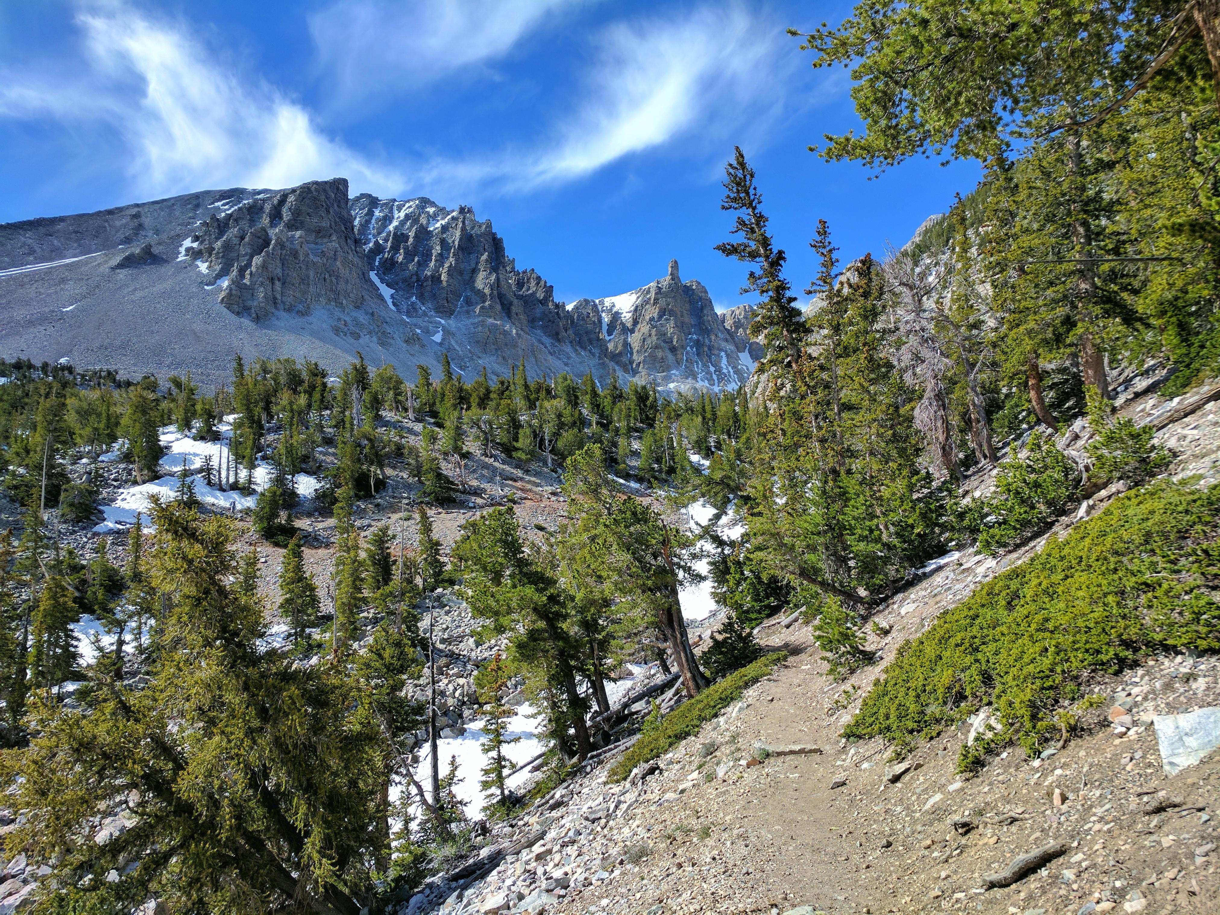
From the 13,063-foot summit of Wheeler Peak to the sagebrush-covered foothills, Great Basin National Park hosts a sample of the incredible diversity of the larger Great Basin region. Come and partake...

16 mi from route ~40 min detour Free near mile 93
Park Closure: Winter Road Closures
Caution: No Potable Water in Park Campgrounds
View on nps.gov

Park data from the National Park Service API. Alerts update every 2 hours.

Fuel & Cost

Regular Gas

$89.59 one way

$179.17 round trip

$5.06/gal 25.4 MPG avg 157 kg CO2
Fuel Type $/gal One Way Round Trip
midgrade $5.36 $94.81 $189.62
premium $5.59 $98.99 $197.97
diesel $5.61 $99.29 $198.58

No toll roads detected on this route.

Estimated Trip Cost (one way, 1 person)

Fuel

$90

Hotel (1n)

$80–$140

Meals

$50–$100

Total

$220–$330

Rough estimate based on US averages. Hotel $80–$140/night, meals $25–$50/day.

Estimated CO2 emission: 157.3 kg one way. Prices: EIA weekly data, 2026-04-13.

Driving Electric?

About $47 in charging · 1 stop · 66% less CO2

Vehicle Type kWh Stops DC Fast Home Charge
Average EV 134.9 1 $47.22 $21.59
Efficient EV 112.4 1 $39.35 $17.99
EV Truck/SUV 179.9 2 $62.96 $28.78

Gas CO2

157 kg

EV CO2

53 kg (66% less)

Plan for 1 charging stop. A 30-minute DC fast charge mid-route should be enough to complete the trip comfortably.

DC fast charging avg $0.35/kWh. Home charging avg $0.16/kWh. US grid CO2: 0.39 kg/kWh.

Travel Intel

Current conditions at both ends of the drive.

Forecast as of Apr 15, 2026

Origin

Caliente, NV

Morning in Caliente on Thursday

Local time

10:53 AM

PDT

Current temp

68°F

Unavailable

Live forecast

Destination

Sparks, NV

Morning in Sparks on Thursday

Local time

10:53 AM

PDT

Current temp

59°F

Unavailable

Live forecast

Seasonal Notes

Summer travel usually means heavier construction, hotter rest stops, and busier weekend traffic around major cities.

Winter travel shortens daylight, so a route that looks manageable on paper can feel much longer after dark.

Holiday weekends tend to make both departure and arrival windows slower than the raw route time suggests.

For long drives, weather on day two can matter just as much as conditions at departure, so check the whole travel window rather than only the first day.

Time zone

Same local time

Origin and destination are on the same clock, so arrival timing is easier to judge at a glance.

Temperature spread

9 degrees cooler at arrival

A meaningful temperature swing is a good cue to rethink layers, water, and how soon you want to arrive.

Road read

8h 48m on the road

This is long enough that the arrival forecast matters almost as much as departure conditions. Recheck both ends before you roll.

Weather data from the National Weather Service. Conditions may change; check closer to your travel date.

Frequently Asked Questions

The drive from Caliente, NV to Sparks, NV covers 449.7 miles and takes about 8h 48m without stops. Add 15-30 minutes for a fuel or rest stop on longer drives.
The main roads are Lincoln Highway, Great Basin Highway, Austin Highway. Expect a mix of highway and local road driving.
Consider an overnight stop or starting very early.
Yes. This route is usually more comfortable as a 2-day drive. A sensible stopping point is after roughly 225 miles on day one.
The midpoint is about 224.9 miles from Caliente, NV. Look for rest areas, gas stations, or food options near the halfway mark.
At current regular gas prices, expect to spend about $89.59 one way. This estimate uses 25.4 MPG — your actual cost will vary with your vehicle's fuel efficiency and current gas prices.
Start early — leave by 6-7 AM to arrive at a reasonable hour. This is a long drive — plan for a morning departure or consider splitting it into two days.
Plan about 2 meaningful breaks for fuel, food, or rest. Plan on a short reset every 3 to 4 hours to stay fresh behind the wheel.
This is a demanding drive. With 12 significant decision points across 449.7 miles, you will need to stay alert - especially through interchange areas and urban stretches. Consider splitting it into segments if you are not comfortable with fast highway navigation.
The main spots that need attention: near the start (US 93 / Front Street): Navigation decision point; at 105.4 miles (US 6; US 50; US 93 / Great Basin Highway): Navigation decision point; at 132.3 miles (US 50 / Aultman Street): Lane positioning matters here.
The route from Caliente, NV to Sparks, NV does not surface many named destination signs beyond the main corridor.

Was this helpful?

Thanks for your feedback!

Your tip has been submitted. Thanks!

/500

Explore More

Return Trip

Sparks, NV to Caliente, NV

Plan the drive back the other way.

449.5 mi 8h 48m

Explore more options from Caliente, NV or browse trips ending in Sparks, NV.

Looking for more statewide routes? Browse NV road trips.

Explore maps for Caliente, NV or Sparks, NV on MapSof.net.