The drive from Cape Coral, FL to East Milton, FL covers 572.3 miles and takes about 10h 30m behind the wheel.
It usually feels better as a 2-day road trip than as one long push.
The route leans on I 75, I 10, North Tamiami Trail for much of the mileage,
and the overall profile is long-distance drive.
The longest uninterrupted segment is about 276.8 miles on I 75.
At current regular gas prices, budget about $91.09 one way before food or hotel costs.
Trip Pace
Best split across 2 days
Treat the return leg as its own travel day rather than an afterthought.
Break Rhythm
3 planned breaks
Plan on a short reset every 3 to 4 hours to stay fresh behind the wheel.
Midpoint
286.1 miles from Cape Coral, FL
A natural place for your longest stop of the day
, about 5h 21m into the drive
.
Drive Character
At 572.3 miles and 10h 30m of driving, this is a route where fuel stops, weather, and timing matter more than any single turn. The main roads are I 75 and I 10.
Most of the miles stay on highways, which makes pacing and fuel planning easier than turn-by-turn city driving.
There are about 19 navigation steps in the underlying route data, so the final approach matters more than the middle miles.
I 75 is the longest continuous segment at about 276.8 miles.
How Hard Is This Drive?
This is a straightforward highway drive that stays mostly on I 75 and I 10. This route has several spots where lane changes, forks, or exits need your full attention. The trickiest moment comes early in the drive near Vincennes Boulevard.
Driving Effort7/10
Demanding - plan breaks and stay ahead of the key maneuvers
Balances navigation complexity with total wheel time.
This is a demanding drive. With 12 significant decision points across 572.3 miles, you will need to stay alert - especially through interchange areas and urban stretches. Consider splitting it into segments if you are not comfortable with fast highway navigation.
Where does it get tricky?
The main spots that need attention: near the start (Vincennes Boulevard): Lane positioning matters here; at 0.1 miles (Vincennes Boulevard): Roundabout - know your exit number before entering; at 301.7 miles: Exit ramp - move to the correct lane early. Lane positioning matters here. Multiple destination signs - pick the right one.
Critical Maneuvers
5 of 12 key points
These are the spots where you need to pay the most attention. Preview them before you drive.
7
0 mi into trip|~0m in|Vincennes Boulevard
Turn right onto Vincennes Boulevard
Lane positioning matters here
Use the right lane.
5
0.1 mi into trip|~0m in|Vincennes Boulevard
Enter roundabout onto Vincennes Boulevard
Roundabout - know your exit number before entering
8
301.7 mi into trip|~5h 38m in
Take the exit toward I 10: Jacksonville, Tallahassee
Exit ramp - move to the correct lane early. Lane positioning matters here. Multiple destination signs - pick the right one
Use the straight / slight right lanes.
Exit 435
Toward I 10: Jacksonville, Tallahassee
8
301.8 mi into trip|~5h 38m in
Keep slight left at fork toward I 10 West: Tallahassee
Highway fork - watch signs carefully. Lane positioning matters here
Use the slight left / slight right lanes.
Toward I 10 West: Tallahassee
7
570 mi into trip|~10h 25m in
Take the exit toward CR 89: Milton
Exit ramp - move to the correct lane early. Lane positioning matters here
Use the slight right lane.
Exit 28
Toward CR 89: Milton
Towns Mentioned on Route Signs
Based on OSRM destination-sign hints, not a full list of every settlement the road passes.
On the drive from Cape Coral, FL to East Milton, FL, road signs begin pointing toward Tallahassee along the way.
Tallahassee
301.7 mi in|~5h 38m
Main Roads
Road
Distance
Duration
I 75
276.8 mi
4h 57m
I 10
267.9 mi
4h 47m
North Tamiami Trail
10.4 mi
12m
Del Prado Boulevard North
6.5 mi
10m
Del Prado Boulevard South
5.2 mi
10m
Ward Basin Road
2 mi
3m
Tuckers Grade
1.1 mi
2m
Coronado Parkway
0.6 mi
1m
Longest stretch:
I 75
— 276.8 mi, about 4h 57m
Turn-by-Turn Driving Directions
Step-by-step road directions between Cape Coral, FL and East Milton, FL.
1
Start on this road
95 ft·7 sec·this road
2
Turn right onto Cape Coral Parkway East
125 ft·7 sec·Cape Coral Parkway East
3
Turn right onto Vincennes Boulevard
357 ft·13 sec·Vincennes Boulevard
Use the right lane.
4
Enter roundabout onto Vincennes Boulevard
61 ft·2 sec·Vincennes Boulevard
5
Continue on Vincennes Boulevard
0.5 mi·1 min·Vincennes Boulevard
6
Turn right onto Coronado Parkway
0.6 mi·1 min·Coronado Parkway
7
Turn left onto CR 867A
5.2 mi·10 min·Del Prado Boulevard South
8
Continue on CR 867A
6.5 mi·10 min·Del Prado Boulevard North
Use the left lane.
9
Turn left onto US 41
10 mi·12 min·North Tamiami Trail
Use the right lane.
10
Turn right onto CR 762
1.1 mi·2 min·Tuckers Grade
11
Take the ramp
0.4 mi·56 sec
Toward I 75 North: Tampa
12
Merge onto I 75
277 mi·4 hr 57 min·I 75
Use the straight / slight right lanes.
13
Take the exit
0.2 mi·15 sec
Exit 435Toward I 10: Jacksonville, TallahasseeUse the straight / slight right lanes.
14
Keep slight left at fork
0.3 mi·30 sec
Toward I 10 West: TallahasseeUse the slight left / slight right lanes.
15
Merge onto I 10
268 mi·4 hr 47 min·I 10
Use the straight / slight right lanes.
16
Take the exit
0.2 mi·47 sec
Exit 28Toward CR 89: MiltonUse the slight right lane.
17
Keep slight left at fork
325 ft·8 sec
18
Turn left onto CR 89
2.0 mi·3 min·Ward Basin Road
19
Arrive at destination
CR 89
Trip Plan
Morning Departure
Start early — leave by 6-7 AM to arrive at a reasonable hour.
Evening Departure
This is a long drive — plan for a morning departure or consider splitting it into two days.
This drive is better paced as a 2-day trip.
Plan roughly 3 meaningful breaks for fuel, food, and rest.
The halfway point lands around 286.1 miles from Cape Coral, FL, or about 5h 21m into the drive.
The longest continuous stretch on this route runs about 276.8 miles.
Consider an overnight stop or starting very early.
Departure
Before you leave
Start with fuel, water, and navigation already sorted so the first hour feels easy.
First stop
Around 126 miles or 2h 29m in
Use this first pause for coffee, a restroom break, and a quick traffic check ahead.
Halfway reset
Around 286.1 miles or 5h 21m in
This is the best place for your longest stop, a real meal, and a full fuel check.
Overnight split
Day 1 wrap after about 286.1 miles or 5h 21m
Stop before fatigue turns the last few hours into a grind. You want day two to start fresh, not just resumed.
Final approach
Final hour starts around 9h 24m
Traffic, exits, and arrival timing usually matter more near East Milton, FL than in the middle of the route.
Before You Leave
+
Open the route before leaving Cape Coral, FL so your first major turns are already loaded.
+
Leave with enough water and a charging cable within reach, not packed away.
+
Check your fuel range against the first long segment, especially if you are starting outside city service areas.
+
Pick one backup stop option before the midpoint in case traffic changes your pacing.
+
Treat this as a 2-day road trip and book the overnight stop before the busiest arrival window.
Day 1
Settle into the route from Cape Coral, FL
Aim for roughly 286 miles and 5.3 hours of wheel time on this day.
Day 2
Finish the approach into East Milton, FL
Aim for roughly 286 miles and 5.3 hours of wheel time on this day.
Your first comfortable stop window is around 126 miles from Cape Coral, FL.
This route usually feels better as a 2-day drive than as one long push.
Plan about 3 real breaks rather than only quick fuel stops.
The longest stretch is on I 75 for about 276.8 miles.
Where to Stop
Rest stops, refuel points, and overnight suggestions along this route.
Halfway Point
Midpoint
About 286.1 mi from Cape Coral, FL
· 5h 21m into the drive
Place data sourced from public business listings. Hours and availability may vary.
National Parks Near This Route
Worth a detour if your schedule allows.
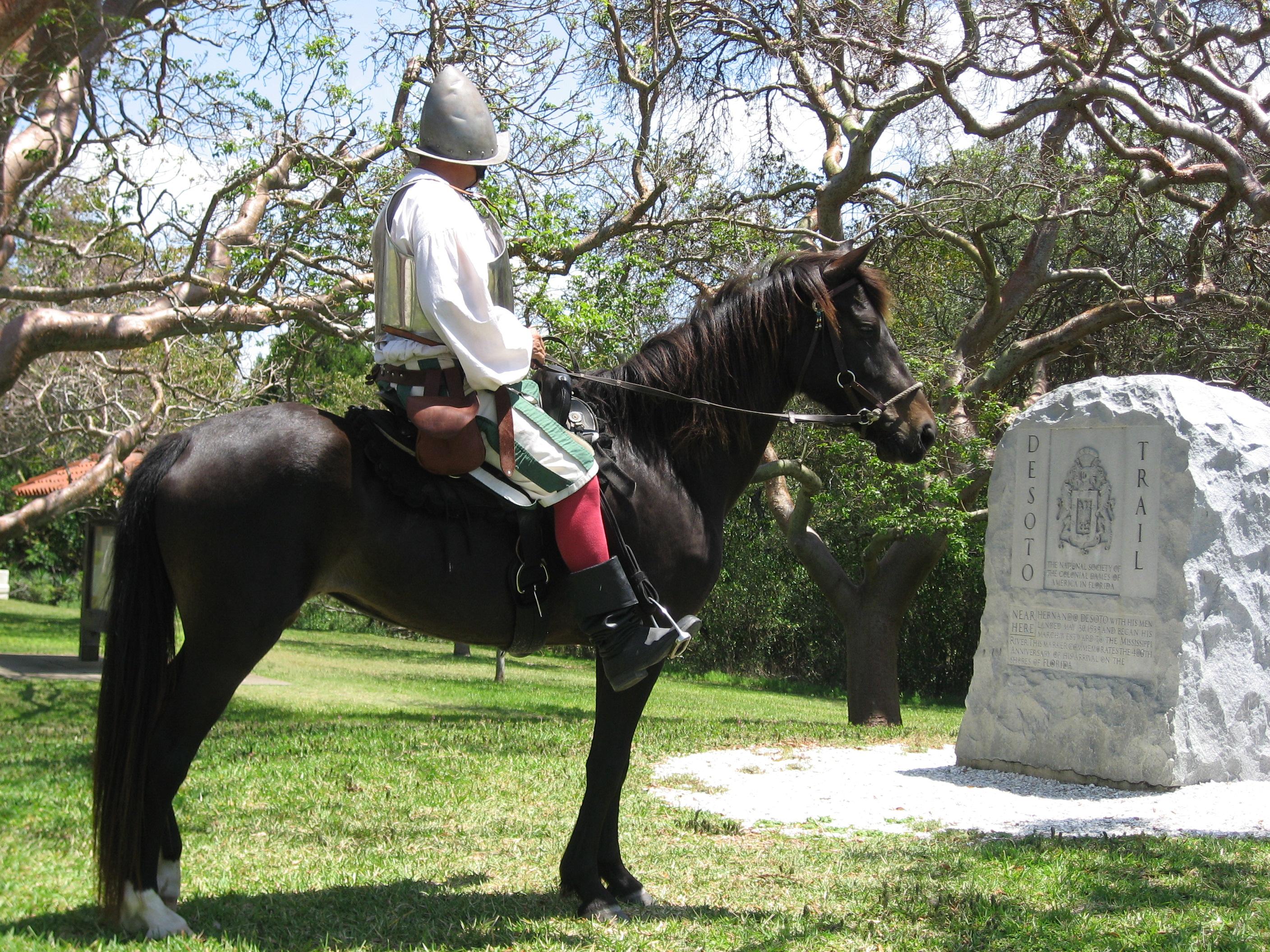
De Soto National Memorial
National Memorial
In May 1539, Conquistador Hernando de Soto’s army of soldiers, hired mercenaries, craftsmen, and clergy made landfall in Tampa Bay. They were met with fierce resistance of indigenous people protecting...
12 mi from route
~30 min detour
Free
near mile 98.7
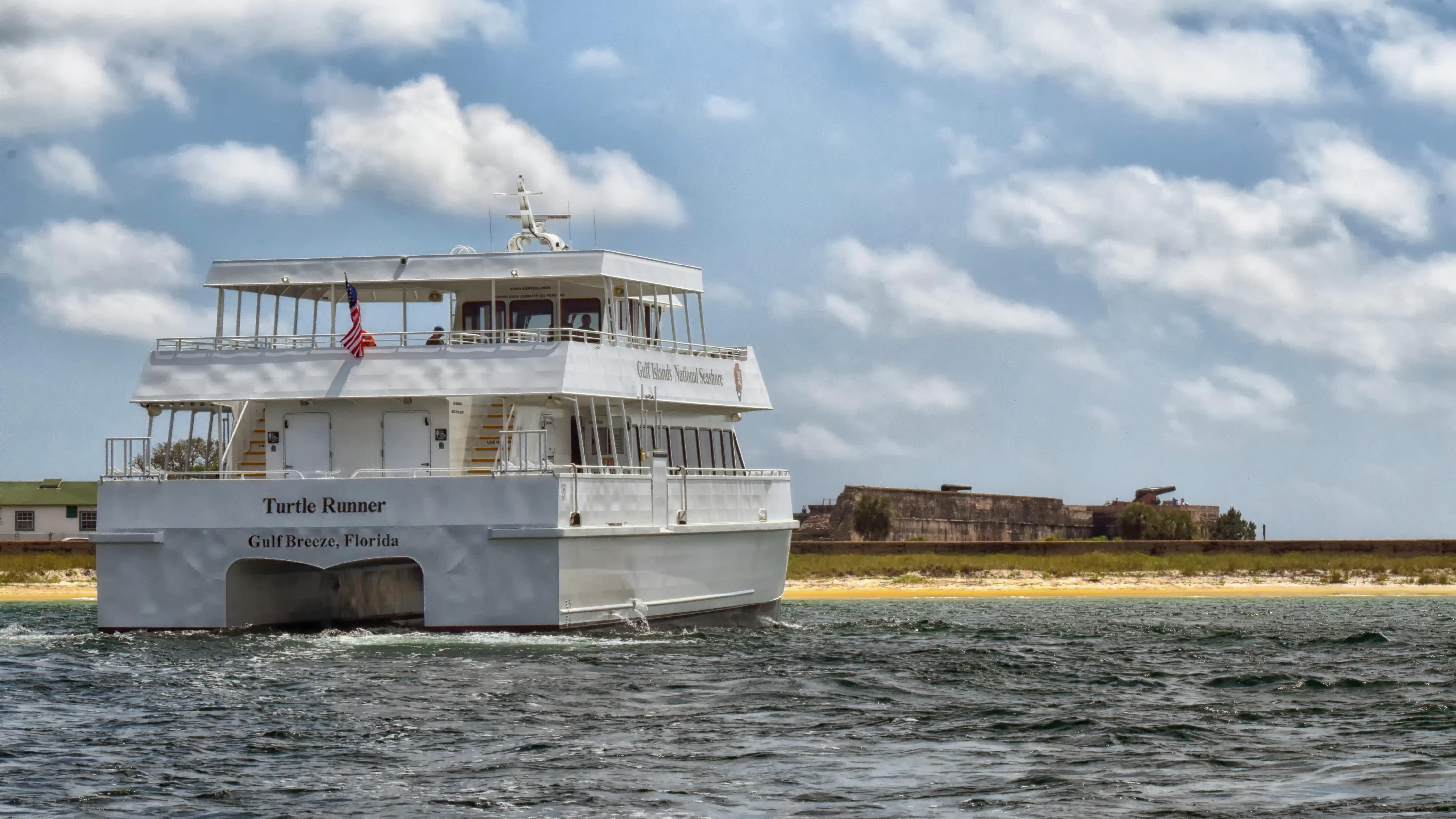
Millions of visitors are drawn to the Gulf of America for Gulf Islands National Seashore's emerald coast waters, magnificent white beaches, fertile marshes and historical landscapes. Come explore with...
24 mi from route
~60 min detour
$25
near mile 572.3
Station data from NREL Alternative Fuel Stations database.
Driving Electric?
About $60 in charging
· 2 stops
· 67% less CO2
Vehicle Type
kWh
Stops
DC Fast
Home Charge
Average EV
171.7
2
$60.09
$27.47
Efficient EV
143.1
1
$50.08
$22.89
EV Truck/SUV
228.9
2
$80.12
$36.63
Gas CO2
200 kg
EV CO2
67 kg (67% less)
Plan for 2 charging stops, roughly every 270 miles. Allow 25-40 minutes per stop at a DC fast charger.
DC fast charging avg $0.35/kWh. Home charging avg $0.16/kWh. US grid CO2: 0.39 kg/kWh.
Travel Intel
Current conditions at both ends of the drive.
Forecast as of Apr 17, 2026
Origin
Cape Coral, FL
Late night
in Cape Coral on Friday
Local time
2:01 AM
EDT
Current temp
67°F
Mostly Clear
NE 2 to 10 mph0% chanceLive forecast
Rip Current Statement
Rip Current Statement issued April 16 at 7:03PM EDT until April 17 at 8:00PM EDT by NWS Miami FL
Rip Current Statement
Rip Current Statement issued April 16 at 3:00AM EDT until April 17 at 2:00AM EDT by NWS Melbourne FL
Destination
East Milton, FL
Late night
in East Milton on Friday
Local time
1:01 AM
CDT
Current temp
57°F
Unavailable
Live forecast
Seasonal Notes
Summer travel usually means heavier construction, hotter rest stops, and busier weekend traffic around major cities.
Winter travel shortens daylight, so a route that looks manageable on paper can feel much longer after dark.
Holiday weekends tend to make both departure and arrival windows slower than the raw route time suggests.
For long drives, weather on day two can matter just as much as conditions at departure, so check the whole travel window rather than only the first day.
Time zone
1 hour earlier
The destination clock does not match departure time, so double-check hotel check-in windows and late arrival plans.
Temperature spread
10 degrees cooler at arrival
A meaningful temperature swing is a good cue to rethink layers, water, and how soon you want to arrive.
Road read
10h 30m on the road
This is long enough that the arrival forecast matters almost as much as departure conditions. Recheck both ends before you roll.
Weather data from the National Weather Service. Conditions may change; check closer to your travel date.
Frequently Asked Questions
The drive from Cape Coral, FL to East Milton, FL covers 572.3 miles and takes about 10h 30m without stops. Add 15-30 minutes for a fuel or rest stop on longer drives.
The main roads are I 75, I 10, North Tamiami Trail. Expect a mix of highway and local road driving.
Consider an overnight stop or starting very early.
Yes. This route is usually more comfortable as a 2-day drive. A sensible stopping point is after roughly 286 miles on day one.
The midpoint is about 286.1 miles from Cape Coral, FL. Look for rest areas, gas stations, or food options near the halfway mark.
At current regular gas prices, expect to spend about $91.09 one way. This estimate uses 25.4 MPG — your actual cost will vary with your vehicle's fuel efficiency and current gas prices.
Start early — leave by 6-7 AM to arrive at a reasonable hour. This is a long drive — plan for a morning departure or consider splitting it into two days.
Plan about 3 meaningful breaks for fuel, food, or rest. Plan on a short reset every 3 to 4 hours to stay fresh behind the wheel.
This is a demanding drive. With 12 significant decision points across 572.3 miles, you will need to stay alert - especially through interchange areas and urban stretches. Consider splitting it into segments if you are not comfortable with fast highway navigation.
The main spots that need attention: near the start (Vincennes Boulevard): Lane positioning matters here; at 0.1 miles (Vincennes Boulevard): Roundabout - know your exit number before entering; at 301.7 miles: Exit ramp - move to the correct lane early. Lane positioning matters here. Multiple destination signs - pick the right one.
On the drive from Cape Coral, FL to East Milton, FL, road signs begin pointing toward Tallahassee along the way.
Yes. Nearby national parks include De Soto National Memorial and Gulf Islands National Seashore.