This 173-mile drive from Chandler, AZ, to Winslow, AZ, will take approximately 3 hours and 56 minutes, making it a very manageable one-day trip. You'll primarily travel on the Beeline Highway and State Highway 87, with about 29% of the journey on faster highway roads. The estimated fuel cost for this journey is around $34. The route offers a turn-heavy local drive feel as you navigate through the Desert Southwest. With just one recommended stop, this trip is perfect for a single day of exploration.
Trip Pace
Same-day drive is realistic
A same-day return is realistic if you keep stops short.
Break Rhythm
1 planned break
A short stop every 2 to 3 hours is enough for this drive.
Midpoint
86.5 miles from Chandler, AZ
A natural place for your longest stop of the day
, about 1h 50m into the drive
.
Who Is This Route For?
Weekend Trip
Doable as a same-day drive at 3h 56m. Total distance: 173 miles.
Family Friendly
Moderate complexity with 1 natural rest stops along the way.
Turn-heavy local drive route profile with national parks nearby.
Drive Character
Expect a turn-heavy local drive experience on this route. While 29% of the journey involves highway driving, much of it will feel more like navigating local roads. The longest uninterrupted stretch you'll encounter is 68.4 miles on the Beeline Highway. As you progress, the road's character shifts, offering a mix of open stretches and more intricate turns. This isn't a monotonous interstate cruise; rather, it's a drive that keeps you engaged with the changing terrain and road conditions.
This route has more turning and local-road decision points than a simple highway run.
There are about 27 navigation steps in the underlying route data, so the final approach matters more than the middle miles.
Beeline Highway is the longest continuous segment at about 68.4 miles.
How Hard Is This Drive?
Expect a hands-on drive with frequent turns and local roads rather than long highway stretches. Navigation is very simple - set it and forget it for most of the drive. The trickiest moment comes around 0.1 miles in near East Chandler Boulevard.
Driving Effort2/10
Very easy - short and simple to drive
Balances navigation complexity with total wheel time.
The drive from Chandler, AZ to Winslow, AZ is easy. At 3h 56m with 29% highway, most drivers will find it relaxed and low-stress.
Where does it get tricky?
The main spots that need attention: at 0.1 miles (East Chandler Boulevard): Navigation decision point; at 0.3 miles (AZ 87 / North Arizona Avenue): Lane positioning matters here; at 85.2 miles (AZ 87; AZ 260 / North Beeline Highway): Roundabout - know your exit number before entering.
Critical Maneuvers
5 of 5 key points
These are the spots where you need to pay the most attention. Preview them before you drive.
3
0.1 mi into trip|~0m in|East Chandler Boulevard
Continue onto East Chandler Boulevard
Navigation decision point
6
0.3 mi into trip|~1m in|AZ 87 / North Arizona Avenue
Turn right onto AZ 87 / North Arizona Avenue
Lane positioning matters here
Use the right lane.
4
85.2 mi into trip|~1h 47m in|AZ 87; AZ 260 / North Beeline Highway
Enter roundabout onto AZ 87; AZ 260 / North Beeline Highway
Roundabout - know your exit number before entering
4
85.8 mi into trip|~1h 49m in|AZ 87; AZ 260 / North Beeline Highway
Enter roundabout onto AZ 87; AZ 260 / North Beeline Highway
Roundabout - know your exit number before entering
5
173 mi into trip|~3h 56m in|I 40 Bus; AZ 99; US 66 Hist / East 3rd Street
Turn left onto I 40 Bus; AZ 99; US 66 Hist / East 3rd Street
Navigation decision point
Main Roads
Road
Distance
Duration
Beeline Highway
68.4 mi
1h 20m
Payson-Winslow Highway
37.4 mi
55m
State Highway 87
27.1 mi
39m
State Route 87
17.8 mi
25m
South Country Club Drive
6.8 mi
12m
North Beeline Highway
6.4 mi
9m
Arizona State Highway 87
4 mi
5m
North Arizona Avenue
4 mi
6m
Longest stretch:
Beeline Highway
— 68.4 mi, about 1h 20m
Turn-by-Turn Driving Directions
Step-by-step road directions between Chandler, AZ and Winslow, AZ.
1
Start on East Chandler Boulevard
0.1 mi·41 sec·East Chandler Boulevard
2
Continue on East Chandler Boulevard
0.2 mi·19 sec·East Chandler Boulevard
3
Turn right onto AZ 87
4.0 mi·6 min·North Arizona Avenue
Use the right lane.
4
Continue on AZ 87
6.8 mi·12 min·South Country Club Drive
Use the left lane.
5
Continue on AZ 87
4.5 mi·5 min·North Beeline Highway
Use the straight / left / right lanes.
6
Continue on AZ 87
68 mi·1 hr 20 min·Beeline Highway
Use the left lane.
7
Continue on AZ 87; AZ 260
1.2 mi·2 min·North Beeline Highway
8
Enter roundabout onto AZ 87; AZ 260
132 ft·2 sec·North Beeline Highway
9
Continue on AZ 87; AZ 260
0.6 mi·1 min·North Beeline Highway
10
Enter roundabout onto AZ 87; AZ 260
114 ft·1 sec·North Beeline Highway
11
Continue on AZ 87; AZ 260
0.1 mi·11 sec·North Beeline Highway
12
Continue on AZ 87; AZ 260
2.6 mi·3 min·Arizona State Highway 87
13
Continue on AZ 87; AZ 260
11 mi·15 min·Payson-Winslow Highway
14
Continue on AZ 87; AZ 260
1.4 mi·2 min·Arizona State Highway 87
15
Continue on AZ 87; AZ 260
0.9 mi·1 min·Payson-Winslow Highway
16
Continue on AZ 87; AZ 260
0.4 mi·55 sec·North AZ Highway 87
17
Continue on AZ 87; AZ 260
7.5 mi·11 min·Payson-Winslow Highway
18
Continue on AZ 87
12 mi·16 min·State Route 87
19
Continue on AZ 87
0.1 mi·9 sec·Payson–Winslow Highway
Use the straight lane.
20
Continue on AZ 87
8.2 mi·11 min·State Highway 87
21
Continue on AZ 87
6.0 mi·8 min·State Route 87
22
Continue on AZ 87
344 ft·5 sec·Starlight Drive
23
Continue on AZ 87
19 mi·28 min·State Highway 87
24
Continue on SR 87
18 mi·27 min·Payson-Winslow Highway
25
Continue on AZ 87; AZ 99
369 ft·13 sec·North Williamson Avenue
26
Turn left onto I 40 Bus; AZ 99; US 66 Hist
296 ft·4 sec·East 3rd Street
27
Arrive at destination
I 40 Bus; AZ 99; US 66 Hist
Trip Plan
Given the 3-hour and 56-minute duration, starting your drive from Chandler, AZ, in the morning is ideal to maximize daylight. Plan for one stop along the 173-mile route to break up the drive, keeping your fuel budget around $34 in mind. The Beeline Highway offers the longest stretch at 68.4 miles, so ensure you have sufficient fuel before embarking on this segment. This is a flexible drive, so you can adjust your timing as needed, but be aware of the turn-heavy local drive nature and drive accordingly.
Morning Departure
An early start around 7-8 AM gets you there with plenty of daylight left.
Evening Departure
A late afternoon start means arriving after dark. Morning is better.
You can normally do this drive in one day.
Plan roughly 1 meaningful break for fuel, food, and rest.
The halfway point lands around 86.5 miles from Chandler, AZ, or about 1h 50m into the drive.
The longest continuous stretch on this route runs about 68.4 miles.
This is a comfortable same-day trip.
Departure
Before you leave
Start with fuel, water, and navigation already sorted so the first hour feels easy.
First stop
Around 38 miles or 51m in
Use this first pause for coffee, a restroom break, and a quick traffic check ahead.
Halfway reset
Around 86.5 miles or 1h 50m in
This is the best place for your longest stop, a real meal, and a full fuel check.
Final approach
Final hour starts around 3h 9m
Traffic, exits, and arrival timing usually matter more near Winslow, AZ than in the middle of the route.
Before You Leave
+
Open the route before leaving Chandler, AZ so your first major turns are already loaded.
+
Leave with enough water and a charging cable within reach, not packed away.
+
Check your fuel range against the first long segment, especially if you are starting outside city service areas.
Day 1
Settle into the route from Chandler, AZ
This is one driving day of about 173 miles and 3h 56m.
Your first comfortable stop window is around 38 miles from Chandler, AZ.
This route can stay practical as a one-day drive if traffic stays reasonable.
Plan about 1 real break rather than only quick fuel stops.
The longest stretch is on Beeline Highway for about 68.4 miles.
Where to Stop
Rest stops, refuel points, and overnight suggestions along this route.
Halfway Point
Midpoint
About 86.5 mi from Chandler, AZ
· 1h 50m into the drive
The midpoint is around 86.5 miles from Chandler, AZ, which is a good place for a longer meal and fuel stop.
Before the longest stretch
Fuel check
Top up before Beeline Highway if your tank is already low. That segment runs about 68.4 miles.
Arriving in Winslow, AZ
The final approach into Winslow, AZ usually feels slower than the middle of the drive, so avoid planning your tightest schedule at the very end.
Try to arrive with enough fuel left to skip an immediate station stop unless you already know the area around Winslow, AZ.
These stop ideas are pacing suggestions — the exact town or exit can change with traffic, hotel plans, and fuel range.
National Parks Near This Route
Worth a detour if your schedule allows.
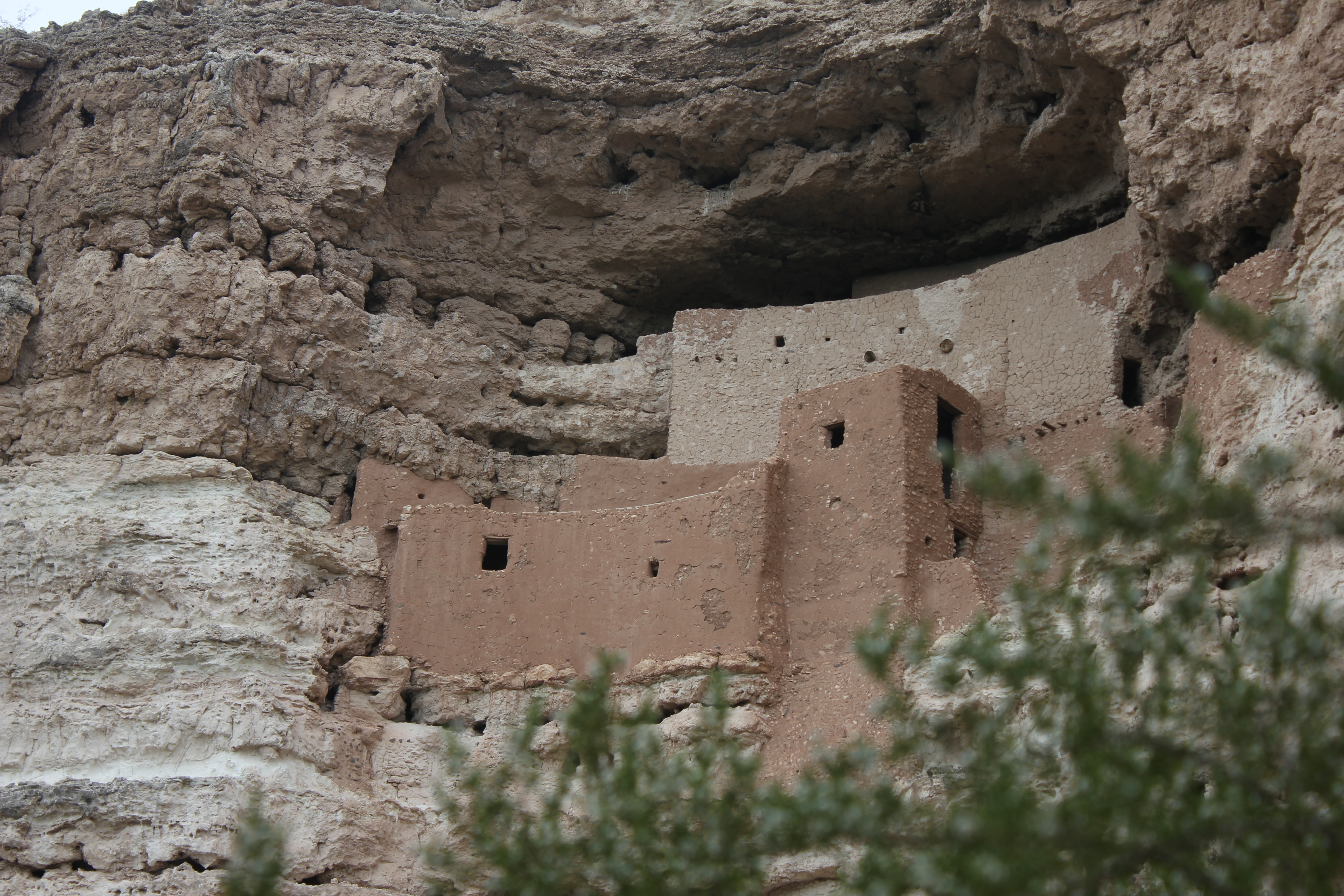
Montezuma Castle National Monument
National Monument
Established December 8, 1906, Montezuma Castle is the third National Monument dedicated to preserving Native American culture. This 20 room high-rise apartment, nestled into a towering limestone cliff...
23 mi from route
~58 min detour
$10
near mile 107.4
Located within the northern range of the Sonoran Desert lie two cliff dwellings that were occupied from 1300-1450 CE (common era). They represent a vibrant culture consisting of local and immigrant gr...
23 mi from route
~58 min detour
$10
near mile 41.8
An Ancestral Sonoran Desert People's farming community and "Great House" are preserved at Casa Grande Ruins. Whether a gathering place for people or simply a waypoint marker in an extensive system of...
Park data from the National Park Service API. Alerts update every 2 hours.
Fuel & Cost
Regular Gas
$34.46 one way
$68.93 round trip
$5.06/gal25.4 MPG avg61 kg CO2
Fuel Type
$/gal
One Way
Round Trip
midgrade
$5.36
$36.47
$72.95
premium
$5.59
$38.08
$76.16
diesel
$5.61
$38.20
$76.39
No toll roads detected on this route.
Estimated Trip Cost (one way, 1 person)
Fuel
$34
Meals
$25–$50
Total
$59–$84
Rough estimate based on US averages. Hotel $80–$140/night, meals $25–$50/day.
Estimated CO2 emission: 60.5 kg one way.
Prices: EIA weekly data, 2026-04-13.
Driving Electric?
About $18 in charging
· 0 stops
· 67% less CO2
Vehicle Type
kWh
Stops
DC Fast
Home Charge
Average EV
51.9
0
$18.17
$8.30
Efficient EV
43.3
0
$15.14
$6.92
EV Truck/SUV
69.2
0
$24.22
$11.07
Gas CO2
61 kg
EV CO2
20 kg (67% less)
This trip is well within single-charge range for most EVs. No charging stops needed if you start fully charged.
DC fast charging avg $0.35/kWh. Home charging avg $0.16/kWh. US grid CO2: 0.39 kg/kWh.
Travel Intel
Current conditions at both ends of the drive.
Forecast as of Apr 16, 2026
Origin
Chandler, AZ
Morning
in Chandler on Friday
Local time
6:47 AM
MST
Current temp
89°F
Partly Sunny
S 0 to 5 mph0% chanceLive forecast
Wind Advisory
Wind Advisory issued April 16 at 3:13AM PDT until April 17 at 5:00AM PDT by NWS Las Vegas NV
Wind Advisory
Wind Advisory issued April 16 at 3:13AM PDT until April 17 at 11:00AM PDT by NWS Las Vegas NV
Destination
Winslow, AZ
Morning
in Winslow on Friday
Local time
6:47 AM
MST
Current temp
75°F
Unavailable
Live forecast
44°F
Payson, AZ
87 mi in
Seasonal Notes
Summer travel usually means heavier construction, hotter rest stops, and busier weekend traffic around major cities.
Winter travel shortens daylight, so a route that looks manageable on paper can feel much longer after dark.
Holiday weekends tend to make both departure and arrival windows slower than the raw route time suggests.
Time zone
Same local time
Origin and destination are on the same clock, so arrival timing is easier to judge at a glance.
Temperature spread
14 degrees cooler at arrival
A meaningful temperature swing is a good cue to rethink layers, water, and how soon you want to arrive.
Road read
3h 56m on the road
The weather snapshot is not static. If you are leaving later, give both cities one more quick forecast check before departure.
Weather data from the National Weather Service. Conditions may change; check closer to your travel date.
Frequently Asked Questions
The drive from Chandler, AZ to Winslow, AZ covers 173 miles and takes about 3h 56m without stops. Add 15-30 minutes for a fuel or rest stop on longer drives.
The main roads are Beeline Highway, Payson-Winslow Highway, State Highway 87. Expect a mix of highway and local road driving.
This is a comfortable same-day trip.
The midpoint is about 86.5 miles from Chandler, AZ. Look for rest areas, gas stations, or food options near the halfway mark.
At current regular gas prices, expect to spend about $34.46 one way. This estimate uses 25.4 MPG — your actual cost will vary with your vehicle's fuel efficiency and current gas prices.
An early start around 7-8 AM gets you there with plenty of daylight left. A late afternoon start means arriving after dark. Morning is better.
Plan about 1 meaningful break for fuel, food, or rest. A short stop every 2 to 3 hours is enough for this drive.
The drive from Chandler, AZ to Winslow, AZ is easy. At 3h 56m with 29% highway, most drivers will find it relaxed and low-stress.
The main spots that need attention: at 0.1 miles (East Chandler Boulevard): Navigation decision point; at 0.3 miles (AZ 87 / North Arizona Avenue): Lane positioning matters here; at 85.2 miles (AZ 87; AZ 260 / North Beeline Highway): Roundabout - know your exit number before entering.
The route from Chandler, AZ to Winslow, AZ does not surface many named destination signs beyond the main corridor.
Yes. Nearby national parks include Montezuma Castle National Monument, Tonto National Monument and Casa Grande Ruins National Monument.
How this page is built
Compiled by the Trip.ovh planning team at COD Solutions Oy from open government datasets — OSRM over OpenStreetMap for geometry, EIA for fuel prices, and NPS for national parks. See our methodology for refresh cadence and limitations.