Trip from City of Portland, ME to Fort Kent, ME

Drive Time

6h 48m

Distance

317.8 mi

511 km

Drive Score

9/10

Great drive

Same Day?

Yes, doable

Fuel Cost

$51

one way

EV Charging

Excellent

11 DC fast

Best Time to Leave

Save up to 35 min
4 AM
6h 37m ★
6 AM
6h 49m
8 AM
7h 12m
10 AM
6h 57m
12 PM
6h 55m
3 PM
6h 58m
5 PM
7h 11m
8 PM
6h 42m

Estimated drive times based on typical traffic patterns. Actual times may vary with weather, construction, and real-time conditions.

Downtown City of Portland, ME, ME

City of Portland, ME

Brett Sayles

Downtown Fort Kent, ME, ME

Fort Kent, ME

Esteban Carriazo

Trip Overview

The drive from City of Portland, ME to Fort Kent, ME covers 317.8 miles and takes about 6h 48m behind the wheel. This route is realistic as a one-day drive if you keep your stops efficient.

The route leans on Maine Turnpike, I 295, Aroostook Road for much of the mileage, and the overall profile is highway-focused drive. The longest uninterrupted segment is about 160.7 miles on Maine Turnpike. At current regular gas prices, budget about $50.87 one way before food or hotel costs.

Trip Pace

Same-day drive is realistic

A same-day return is possible, but it will make for a full day on the road.

Break Rhythm

1 planned break

Plan on a short reset every 3 to 4 hours to stay fresh behind the wheel.

Midpoint

158.9 miles from City of Portland, ME

A natural place for your longest stop of the day , about 3h 14m into the drive .

Drive Character

This is a 6h 48m highway drive covering 317.8 miles, with most of the trip on Maine Turnpike and I 295. The longest continuous stretch is about 160.7 miles on Maine Turnpike.

Most of the miles stay on highways, which makes pacing and fuel planning easier than turn-by-turn city driving.
There are about 34 navigation steps in the underlying route data, so the final approach matters more than the middle miles.
Maine Turnpike is the longest continuous segment at about 160.7 miles.

How Hard Is This Drive?

This is a straightforward highway drive that stays mostly on Maine Turnpike and I 295. There are only a few real navigation decisions along the way. The trickiest moment comes around 0.6 miles in near Seashore Avenue.

Route Complexity 4/10

Easy - simple navigation with a manageable amount of wheel time

The route itself is not hard, but at 6h 48m, endurance matters. Plan breaks every 2-3 hours. The 15 decision points are all manageable with basic attention.

Where does it get tricky?

The main spots that need attention: at 0.6 miles (Seashore Avenue): Navigation decision point; at 1 miles (Welch Street): Complex interchange - multiple decisions in a short stretch; at 5 miles (I 295; US 1): Merge point - match speed before joining. Lane positioning matters here.

Critical Maneuvers

5 of 15 key points

These are the spots where you need to pay the most attention. Preview them before you drive.

4
0.6 mi into trip | ~2m in | Seashore Avenue

At end of road, turn left onto Seashore Avenue

Navigation decision point

6
1 mi into trip | ~3m in | Welch Street

At end of road, turn left onto Welch Street

Complex interchange - multiple decisions in a short stretch

5
5 mi into trip | ~28m in | I 295; US 1

Merge onto I 295; US 1

Merge point - match speed before joining. Lane positioning matters here

Use the straight / slight right lanes.
6
211.9 mi into trip | ~4h 9m in

Take the exit toward ME 158: Sherman, Patten

Exit ramp - move to the correct lane early. Multiple destination signs - pick the right one

Exit 264 Toward ME 158: Sherman, Patten
5
212.2 mi into trip | ~4h 10m in

Keep slight left at fork

Highway fork - watch signs carefully

Towns Along This Route

On the drive from City of Portland, ME to Fort Kent, ME, road signs begin pointing toward Patten along the way.

Patten

211.9 mi in | ~4h 9m

Main Roads

Road Distance Duration
Maine Turnpike 160.7 mi 2h 49m
I 295 46.3 mi 52m
Aroostook Road 30.6 mi 45m
Aroostook Scenic Highway 30.2 mi 44m
Portage Road 15.3 mi 22m
Masardis Road 11.7 mi 17m
Station Road 5.2 mi 7m
North Road 4.4 mi 6m
Longest stretch: Maine Turnpike — 160.7 mi, about 2h 49m

Turn-by-Turn Driving Directions

Step-by-step road directions between City of Portland, ME and Fort Kent, ME.

1

Start on Seashore Avenue

0.6 mi · 2 min · Seashore Avenue
2

At end of road, turn left onto Seashore Avenue

0.2 mi · 45 sec · Seashore Avenue
3

Continue on Whitehead Street

351 ft · 15 sec · Whitehead Street
4

Continue on Oakland Avenue

0.1 mi · 31 sec · Oakland Avenue
5

At end of road, turn left onto Welch Street

0.2 mi · 1 min · Welch Street
6

Continue on Portland - Peaks Island

2.5 mi · 20 min · Portland - Peaks Island
7

Continue

187 ft · 14 sec
8

Turn right onto Maine State Pier

74 ft · 30 sec · Maine State Pier
9

Continue on Maine State Pier

0.1 mi · 30 sec · Maine State Pier
10

Continue on US 1A

0.7 mi · 1 min · Franklin Street
11

Take the ramp onto US 1A

0.3 mi · 39 sec · US 1A
12

Merge onto I 295; US 1

46 mi · 52 min · I 295; US 1
Use the straight / slight right lanes.
13

Merge onto I 95

161 mi · 2 hr 49 min · Maine Turnpike
14

Take the exit

0.3 mi · 42 sec
Exit 264 Toward ME 158: Sherman, Patten
15

Keep slight left at fork

70 ft · 2 sec
16

Turn left onto Main Street

0.4 mi · 32 sec · Main Street
17

Continue on Station Road

1.7 mi · 2 min · Station Road
18

Continue on Route 11

0.2 mi · 15 sec · Route 11
19

Continue on ME 11

3.5 mi · 5 min · Station Road
20

Continue on ME 11

3.2 mi · 4 min · South Patten Road
21

Continue on ME 11

1.1 mi · 2 min · Main Street
22

Continue on ME 11

4.4 mi · 6 min · North Road
23

Continue on ME 11

30 mi · 44 min · Aroostook Scenic Highway
24

Continue on ME 11

12 mi · 17 min · Masardis Road
25

Continue on ME 11

0.4 mi · 42 sec · Main Street
26

Turn left onto ME 11

0.8 mi · 1 min · Station Street
27

At end of road, turn right onto ME 11

15 mi · 22 min · Portage Road
28

Continue on ME 11

31 mi · 45 min · Aroostook Road
29

Continue on ME 11

0.6 mi · 1 min · Pleasant Street
30

Turn right onto Bridge Street

0.1 mi · 20 sec · Bridge Street
31

Turn left onto ME 161

1.3 mi · 1 min · Market Street
32

Turn right onto US 1

301 ft · 10 sec · East Main Street
33

Turn right onto Highland Avenue

88 ft · 4 sec · Highland Avenue
34

Arrive at destination

Highland Avenue

Trip Plan

Morning Departure

Start early — leave by 6-7 AM to arrive at a reasonable hour.

Evening Departure

This is a long drive — plan for a morning departure or consider splitting it into two days.

You can normally do this drive in one day.
Plan roughly 1 meaningful break for fuel, food, and rest.
The halfway point lands around 158.9 miles from City of Portland, ME, or about 3h 14m into the drive.
The longest continuous stretch on this route runs about 160.7 miles.

This is a comfortable same-day trip.

Departure

Before you leave

Start with fuel, water, and navigation already sorted so the first hour feels easy.

First stop

Around 80 miles or 1h 50m in

Use this first pause for coffee, a restroom break, and a quick traffic check ahead.

Halfway reset

Around 158.9 miles or 3h 14m in

This is the best place for your longest stop, a real meal, and a full fuel check.

Final approach

Final hour starts around 5h 23m

Traffic, exits, and arrival timing usually matter more near Fort Kent, ME than in the middle of the route.

Before You Leave

+

Open the route before leaving City of Portland, ME so your first major turns are already loaded.

+

Leave with enough water and a charging cable within reach, not packed away.

+

Check your fuel range against the first long segment, especially if you are starting outside city service areas.

Day 1

Settle into the route from City of Portland, ME

This is one driving day of about 317.8 miles and 6h 48m.

Your first comfortable stop window is around 80 miles from City of Portland, ME.
This route can stay practical as a one-day drive if traffic stays reasonable.
Plan about 1 real break rather than only quick fuel stops.
The longest stretch is on Maine Turnpike for about 160.7 miles.

Where to Stop

Rest stops, refuel points, and overnight suggestions along this route.

Halfway Point

Midpoint

About 158.9 mi from City of Portland, ME · 3h 14m into the drive

Mid-route town

Meal stop

Lincoln, ME

159 mi into the route

Best for: Lunch, fuel, and a longer reset

This sits close to the middle of the route, so it works well for the longest stop of the day.

Pacing Suggestions

Brunswick, ME

Fuel and coffee

A short stop after about 80 miles helps settle the day before fatigue starts building.

Brunswick, ME

Meal break

The midpoint is around 158.9 miles from City of Portland, ME, which is a good place for a longer meal and fuel stop.

Before the longest stretch

Fuel check

Top up before Maine Turnpike if your tank is already low. That segment runs about 160.7 miles.

Arriving in Fort Kent, ME

The final approach into Fort Kent, ME usually feels slower than the middle of the drive, so avoid planning your tightest schedule at the very end.

Try to arrive with enough fuel left to skip an immediate station stop unless you already know the area around Fort Kent, ME.

After long uninterrupted mileage, take five minutes before the last urban segment to reset and refocus on exits, merges, and city traffic.

These stop ideas are pacing suggestions — the exact town or exit can change with traffic, hotel plans, and fuel range.

National Parks Near This Route

Worth a detour if your schedule allows.

Katahdin Woods and Waters National Monument

Katahdin Woods and Waters National Monument

National Monument

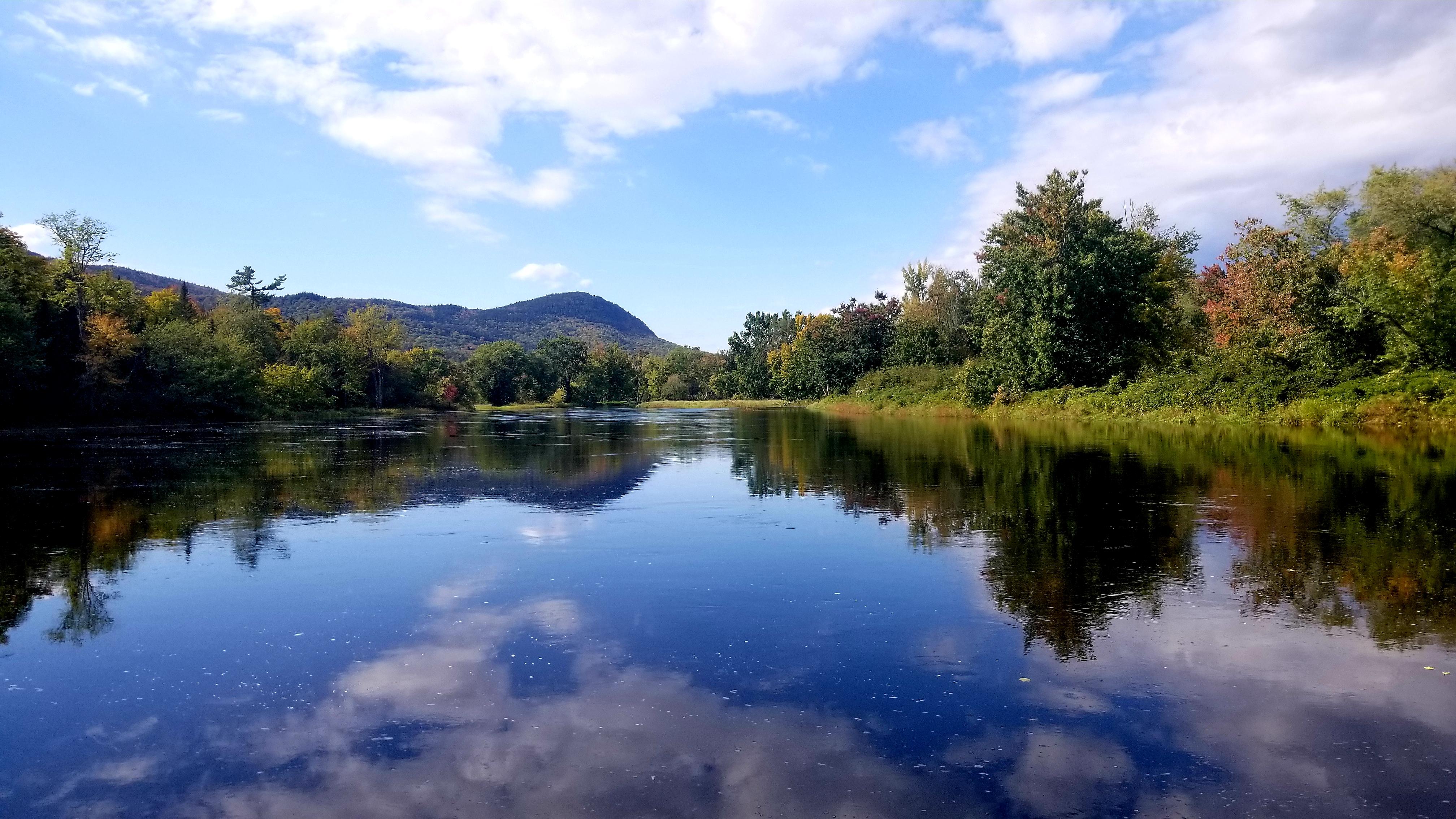
Spread across a wild landscape offering spectacular views of Katahdin, Katahdin Woods and Waters invites discovery of its rivers, streams, woods, flora, fauna, geology, and the night skies that have a...

13 mi from route ~31 min detour Free near mile 219.2
Park Closure: Loop Road and North Entrance Seasonal Closures
Park Closure: Katahdin Overlook Construction Closure
View on nps.gov
Frances Perkins National Monument

Frances Perkins National Monument

National Monument

Known as the first woman to hold a presidential cabinet position and the “Woman behind the New Deal,” Frances Perkins championed many labor rights that Americans enjoy today, including safety standard...

17 mi from route ~42 min detour Free near mile 43.8
View on nps.gov

Park data from the National Park Service API. Alerts update every 2 hours.

Fuel & Cost

Regular Gas

$50.87 one way

$101.75 round trip

$4.07/gal 25.4 MPG avg 111 kg CO2
Fuel Type $/gal One Way Round Trip
midgrade $4.46 $55.77 $111.53
premium $4.83 $60.41 $120.81
diesel $5.64 $70.60 $141.21

Estimated Tolls: $9.64

Maine Turnpike (160.7 mi) $9.64

Toll estimates based on average 2024-2025 rates. EZ-Pass/SunPass discounts may lower the actual cost.

Estimated Trip Cost (one way, 1 person)

Fuel

$51

Tolls

$10

Meals

$25–$50

Total

$86–$111

Rough estimate based on US averages. Hotel $80–$140/night, meals $25–$50/day.

Estimated CO2 emission: 111.2 kg one way. Prices: EIA weekly data, 2026-04-06.

EV Charging Along Route

11 DC fast chargers · Coverage: excellent

Hannaford Supermarket - Tesla Supercharger

Portland, ME

Tesla

12 DCFC

Pine Tree Shopping Center - Tesla Supercharger

Portland, ME

Tesla

12 DCFC

Yankee Ford

South Portland, ME

FORD_CHARGE

4 DCFC

High St. Lot

Portland, ME

eVgo Network

4 DCFC

Miss Portland Diner

Portland, ME

JULE

4 DCFC

Rowe Ford Sales

Westbrook, ME

FORD_CHARGE

4 DCFC

Bill Dodge Cadillac

WESTBROOK, ME

EV Connect

2 DCFC

Market Basket Westbrook #85

Westbrook, ME

eVgo Network

2 DCFC

FORD_CHARGE: 2 eVgo Network: 2 Tesla: 2 ChargePoint Network: 2 Non-Networked: 1 JULE: 1 EV Connect: 1

Station data from NREL Alternative Fuel Stations database.

Driving Electric?

About $33 in charging · 1 stop · 67% less CO2

Vehicle Type kWh Stops DC Fast Home Charge
Average EV 95.3 1 $33.37 $15.25
Efficient EV 79.5 0 $27.81 $12.71
EV Truck/SUV 127.1 1 $44.49 $20.34

Gas CO2

111 kg

EV CO2

37 kg (67% less)

Plan for 1 charging stop. A 30-minute DC fast charge mid-route should be enough to complete the trip comfortably.

DC fast charging avg $0.35/kWh. Home charging avg $0.16/kWh. US grid CO2: 0.39 kg/kWh.

Travel Intel

Current conditions at both ends of the drive.

Forecast data refreshed 2 years ago

Origin

City of Portland, ME

Morning in City of Portland on Monday

Local time

10:58 AM

EDT

Current temp

43°F

Unavailable

Live forecast

Destination

Fort Kent, ME

Morning in Fort Kent on Monday

Local time

10:58 AM

EDT

Current temp

31°F

Unavailable

Live forecast

Along the Route

42°F

Lincoln, ME

159 mi in

Seasonal Notes

Summer travel usually means heavier construction, hotter rest stops, and busier weekend traffic around major cities.

Winter travel shortens daylight, so a route that looks manageable on paper can feel much longer after dark.

Holiday weekends tend to make both departure and arrival windows slower than the raw route time suggests.

Time zone

Same local time

Origin and destination are on the same clock, so arrival timing is easier to judge at a glance.

Temperature spread

12 degrees cooler at arrival

A meaningful temperature swing is a good cue to rethink layers, water, and how soon you want to arrive.

Road read

6h 48m on the road

Start early — leave by 6-7 AM to arrive at a reasonable hour.

Weather data from the National Weather Service. Conditions may change; check closer to your travel date.

Frequently Asked Questions

The drive from City of Portland, ME to Fort Kent, ME covers 317.8 miles and takes about 6h 48m without stops. Add 15-30 minutes for a fuel or rest stop on longer drives.
The main roads are Maine Turnpike, I 295, Aroostook Road. Most of the drive stays on highways, so watch for ramps and exits.
This is a comfortable same-day trip.
The midpoint is about 158.9 miles from City of Portland, ME. Look for rest areas, gas stations, or food options near the halfway mark.
At current regular gas prices, expect to spend about $50.87 one way. This estimate uses 25.4 MPG — your actual cost will vary with your vehicle's fuel efficiency and current gas prices.
Start early — leave by 6-7 AM to arrive at a reasonable hour. This is a long drive — plan for a morning departure or consider splitting it into two days.
Plan about 1 meaningful break for fuel, food, or rest. Plan on a short reset every 3 to 4 hours to stay fresh behind the wheel.
The route itself is not hard, but at 6h 48m, endurance matters. Plan breaks every 2-3 hours. The 15 decision points are all manageable with basic attention.
The main spots that need attention: at 0.6 miles (Seashore Avenue): Navigation decision point; at 1 miles (Welch Street): Complex interchange - multiple decisions in a short stretch; at 5 miles (I 295; US 1): Merge point - match speed before joining. Lane positioning matters here.
On the drive from City of Portland, ME to Fort Kent, ME, road signs begin pointing toward Patten along the way.

Was this route helpful?

Thanks for your feedback!

Your tip has been submitted. Thanks!

/500

Explore More

Return Trip

Fort Kent, ME to City of Portland, ME

Plan the drive back the other way.

317.8 mi 6h 49m

Explore more options from City of Portland, ME or browse trips ending in Fort Kent, ME.

Looking for more statewide routes? Browse ME road trips.

Explore maps for City of Portland, ME or Fort Kent, ME on MapSof.net.