Trip from Colorado Springs, CO to Orchard City, CO

Drive Time

6h 13m

Distance

265.4 mi

427 km

Drive Score

8/10

Great drive

Same Day?

Yes, doable

Fuel Cost

$40

one way

EV Charging

None

0 DC fast

Best Time to Leave

Save up to 38 min
4 AM
6h 1m ★
6 AM
6h 13m
8 AM
6h 39m
10 AM
6h 22m
12 PM
6h 20m
3 PM
6h 24m
5 PM
6h 38m
8 PM
6h 6m

Estimated drive times based on typical traffic patterns. Actual times may vary with weather, construction, and real-time conditions.

Trip Overview

The drive from Colorado Springs, CO to Orchard City, CO covers 265.4 miles and takes about 6h 13m behind the wheel. This route is realistic as a one-day drive if you keep your stops efficient.

The route leans on US 50, US 24, US 285 for much of the mileage, and the overall profile is highway-focused drive. The longest uninterrupted segment is about 136.8 miles on US 50. At current regular gas prices, budget about $40.22 one way before food or hotel costs.

Trip Pace

Same-day drive is realistic

A same-day return is possible, but it will make for a full day on the road.

Break Rhythm

1 planned break

Plan on a short reset every 3 to 4 hours to stay fresh behind the wheel.

Midpoint

132.7 miles from Colorado Springs, CO

A natural place for your longest stop of the day , about 3h 2m into the drive .

Drive Character

This is a 6h 13m highway drive covering 265.4 miles, with most of the trip on US 50 and US 24. The longest continuous stretch is about 136.8 miles on US 50.

Most of the miles stay on highways, which makes pacing and fuel planning easier than turn-by-turn city driving.
There are about 26 navigation steps in the underlying route data, so the final approach matters more than the middle miles.
US 50 is the longest continuous segment at about 136.8 miles.

How Hard Is This Drive?

This is a straightforward highway drive that stays mostly on US 50 and US 24. There are only a few real navigation decisions along the way. The trickiest moment comes around 0.1 miles in near East Colorado Avenue.

Route Complexity 4/10

Easy - simple navigation with a manageable amount of wheel time

The route itself is not hard, but at 6h 13m, endurance matters. Plan breaks every 2-3 hours. The 16 decision points are all manageable with basic attention.

Where does it get tricky?

The main spots that need attention: at 0.1 miles (East Colorado Avenue): Navigation decision point; at 1.2 miles (South Limit Street): Sharp turn - reduce speed on approach; at 77.5 miles (US 24; US 285): Navigation decision point.

Critical Maneuvers

5 of 16 key points

These are the spots where you need to pay the most attention. Preview them before you drive.

5
0.1 mi into trip | ~0m in | East Colorado Avenue

Turn right onto East Colorado Avenue

Navigation decision point

5
1.2 mi into trip | ~3m in | South Limit Street

Turn sharp left onto South Limit Street

Sharp turn - reduce speed on approach

5
77.5 mi into trip | ~1h 40m in | US 24; US 285

At end of road, turn left onto US 24; US 285

Navigation decision point

5
91.2 mi into trip | ~1h 58m in | US 285

At end of road, turn left onto US 285

Navigation decision point

6
235.4 mi into trip | ~5h 29m in | US 50 / North San Juan Avenue

Turn right onto US 50 / North San Juan Avenue

Lane positioning matters here

Use the right lane.

Main Roads

Road Distance Duration
US 50 136.8 mi 3h 13m
US 24 71.7 mi 1h 27m
US 285 21 mi 33m
Midland Expressway 15.7 mi 23m
CO 65 5.2 mi 8m
North Townsend Avenue 2.8 mi 4m
West Cimarron Street 2.4 mi 3m
1900 Road 1.9 mi 3m
Longest stretch: US 50 — 136.8 mi, about 3h 13m

Turn-by-Turn Driving Directions

Step-by-step road directions between Colorado Springs, CO and Orchard City, CO.

1

Start on East Pikes Peak Avenue

66 ft · 4 sec · East Pikes Peak Avenue
2

Turn left onto South Nevada Avenue

0.1 mi · 33 sec · South Nevada Avenue
3

Turn right onto East Colorado Avenue

0.2 mi · 37 sec · East Colorado Avenue
4

Continue on West Colorado Avenue

0.9 mi · 2 min · West Colorado Avenue
5

Turn sharp left onto South Limit Street

0.2 mi · 20 sec · South Limit Street
6

Turn right onto US 24

2.4 mi · 3 min · West Cimarron Street
7

Continue on US 24

16 mi · 23 min · Midland Expressway
8

Keep slight right at fork onto US 24; CO 67

45 mi · 54 min · US 24; CO 67
9

Continue on US 24; CO 9

13 mi · 14 min · US 24; CO 9
10

At end of road, turn left onto US 24; US 285

14 mi · 18 min · US 24; US 285
11

At end of road, turn left onto US 285

11 mi · 17 min · US 285
12

Continue on US 285

9.9 mi · 15 min · US 285
13

Turn sharp right onto US 50

123 mi · 2 hr 57 min · US 50
Use the straight lane.
14

Turn right onto US 50

1.4 mi · 2 min · North San Juan Avenue
Use the right lane.
15

Turn right onto US 50

2.8 mi · 4 min · North Townsend Avenue
Use the straight lane.
16

Continue on US 50

14 mi · 16 min · US 50
17

Turn right onto D Road

0.8 mi · 1 min · D Road
18

Continue on 1900 Road

1.9 mi · 3 min · 1900 Road
19

At end of road, turn left onto F Road

0.8 mi · 1 min · F Road
20

Turn right onto 1825 Road

0.9 mi · 1 min · 1825 Road
21

Continue on 1800 Road

1.4 mi · 2 min · 1800 Road
22

Turn right onto CO 92

1.3 mi · 1 min · CO 92
23

Turn left onto CO 65

5.2 mi · 8 min · CO 65
Use the left lane.
24

Turn right onto 2100 Road

396 ft · 22 sec · 2100 Road
25

Turn left onto Fruitgrowers Road

38 ft · 1 sec · Fruitgrowers Road
26

Arrive at destination

Fruitgrowers Road

Trip Plan

Morning Departure

Start early — leave by 6-7 AM to arrive at a reasonable hour.

Evening Departure

This is a long drive — plan for a morning departure or consider splitting it into two days.

You can normally do this drive in one day.
Plan roughly 1 meaningful break for fuel, food, and rest.
The halfway point lands around 132.7 miles from Colorado Springs, CO, or about 3h 2m into the drive.
The longest continuous stretch on this route runs about 136.8 miles.

This is a comfortable same-day trip.

Departure

Before you leave

Start with fuel, water, and navigation already sorted so the first hour feels easy.

First stop

Around 80 miles or 1h 43m in

Use this first pause for coffee, a restroom break, and a quick traffic check ahead.

Halfway reset

Around 132.7 miles or 3h 2m in

This is the best place for your longest stop, a real meal, and a full fuel check.

Final approach

Final hour starts around 5h 4m

Traffic, exits, and arrival timing usually matter more near Orchard City, CO than in the middle of the route.

Before You Leave

+

Open the route before leaving Colorado Springs, CO so your first major turns are already loaded.

+

Leave with enough water and a charging cable within reach, not packed away.

+

Check your fuel range against the first long segment, especially if you are starting outside city service areas.

Day 1

Settle into the route from Colorado Springs, CO

This is one driving day of about 265.4 miles and 6h 13m.

Your first comfortable stop window is around 80 miles from Colorado Springs, CO.
This route can stay practical as a one-day drive if traffic stays reasonable.
Plan about 1 real break rather than only quick fuel stops.
The longest stretch is on US 50 for about 136.8 miles.

Where to Stop

Rest stops, refuel points, and overnight suggestions along this route.

Halfway Point

Midpoint

About 132.7 mi from Colorado Springs, CO · 3h 2m into the drive

Downtown Aspen, CO, CO

Mid-route town

Meal stop

Aspen, CO

133 mi into the route

Best for: Lunch, fuel, and a longer reset

This sits close to the middle of the route, so it works well for the longest stop of the day.

Pacing Suggestions

Cripple Creek, CO

Fuel and coffee

A short stop after about 80 miles helps settle the day before fatigue starts building.

Aspen, CO

Meal break

The midpoint is around 132.7 miles from Colorado Springs, CO, which is a good place for a longer meal and fuel stop.

Before the longest stretch

Fuel check

Top up before US 50 if your tank is already low. That segment runs about 136.8 miles.

Arriving in Orchard City, CO

The final approach into Orchard City, CO usually feels slower than the middle of the drive, so avoid planning your tightest schedule at the very end.

Try to arrive with enough fuel left to skip an immediate station stop unless you already know the area around Orchard City, CO.

After long uninterrupted mileage, take five minutes before the last urban segment to reset and refocus on exits, merges, and city traffic.

These stop ideas are pacing suggestions — the exact town or exit can change with traffic, hotel plans, and fuel range.

National Parks Near This Route

Worth a detour if your schedule allows.

Curecanti National Recreation Area

Curecanti National Recreation Area

National Recreation Area

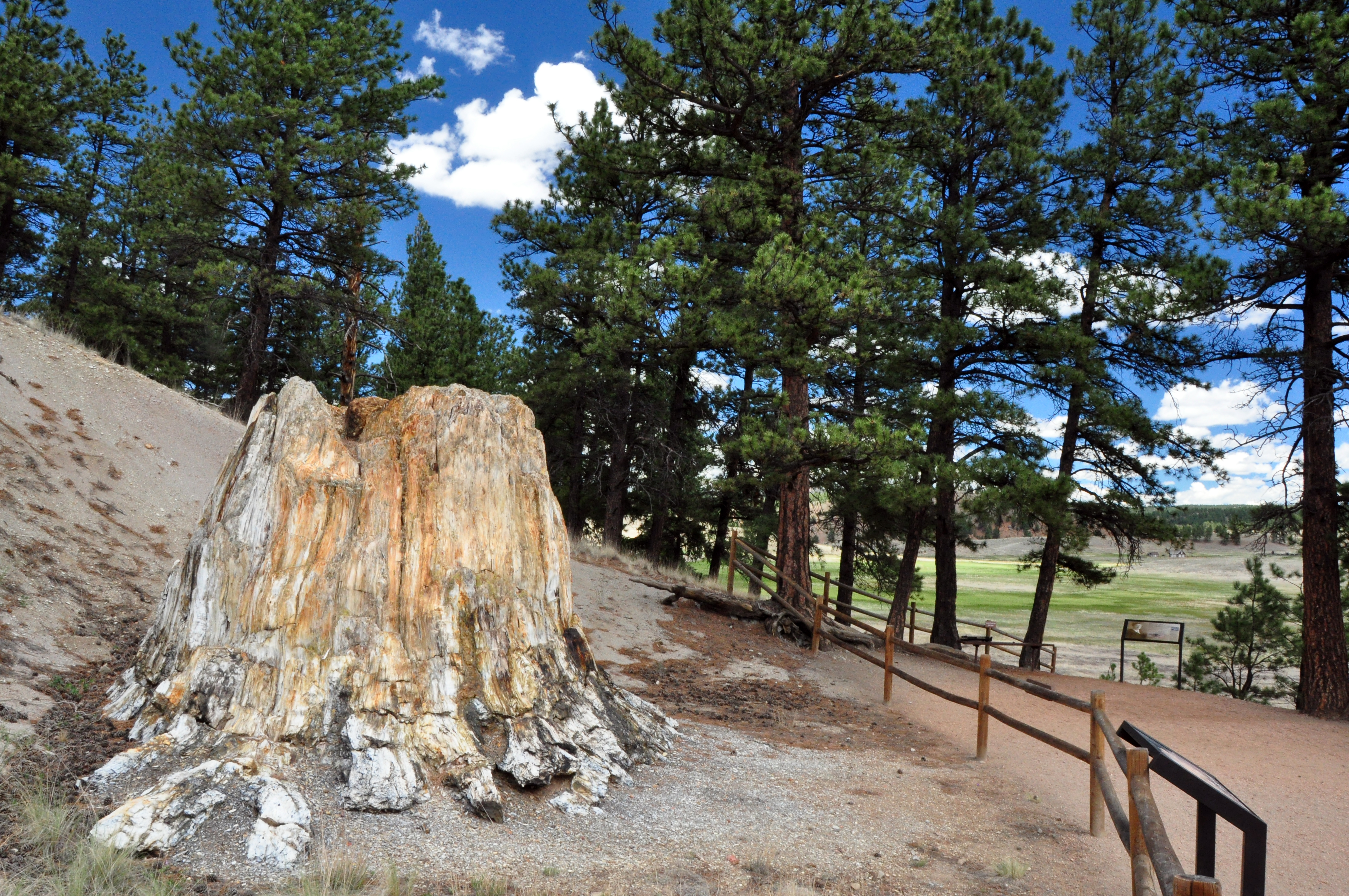
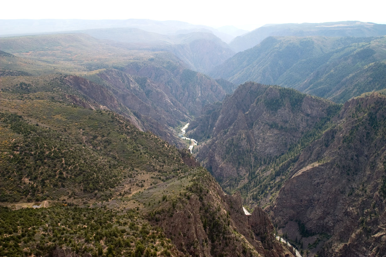
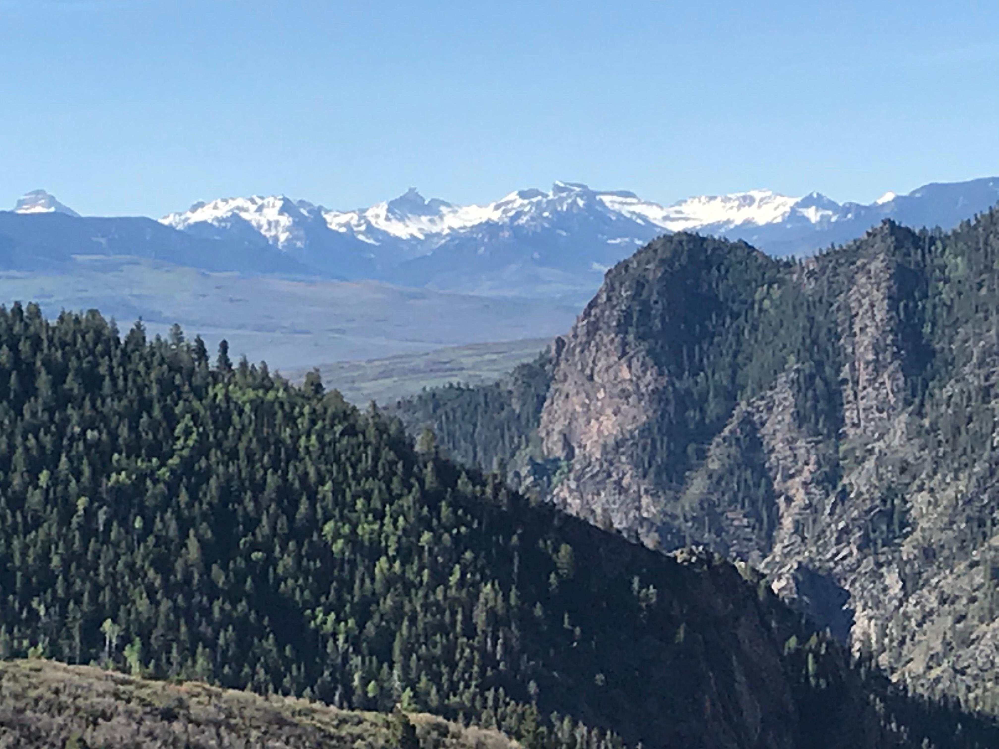
Three reservoirs and surrounding lands make up this recreation area in western Colorado. It is a landscape of tradeoffs; natural and human made features exist together. Geologic wonders are abundant f...

3 mi from route ~7 min detour Free near mile 201.3
View on nps.gov
Florissant Fossil Beds National Monument

Florissant Fossil Beds National Monument

National Monument

Beneath a grassy mountain valley in central Colorado lies one of the richest and most diverse fossil deposits in the world. Petrified redwood stumps up to 14 feet wide and thousands of detailed fossil...

4 mi from route ~10 min detour $10 near mile 36.6
View on nps.gov
Black Canyon Of The Gunnison National Park

Black Canyon Of The Gunnison National Park

National Park

Big enough to be overwhelming, yet still intimate enough to feel the pulse of time. Come see some of the steepest cliffs, oldest rock, and craggiest spires in North America. Forces of nature and the G...

6 mi from route ~16 min detour $30 near mile 228.8
View on nps.gov

Park data from the National Park Service API. Alerts update every 2 hours.

Fuel & Cost

Regular Gas

$40.22 one way

$80.44 round trip

$3.85/gal 25.4 MPG avg 93 kg CO2
Fuel Type $/gal One Way Round Trip
midgrade $4.08 $42.67 $85.35
premium $4.43 $46.32 $92.64
diesel $5.64 $58.96 $117.93

No toll roads detected on this route.

Estimated Trip Cost (one way, 1 person)

Fuel

$40

Meals

$25–$50

Total

$65–$90

Rough estimate based on US averages. Hotel $80–$140/night, meals $25–$50/day.

Estimated CO2 emission: 92.9 kg one way. Prices: EIA weekly data, 2026-04-06.

Driving Electric?

About $28 in charging · 0 stops · 67% less CO2

Vehicle Type kWh Stops DC Fast Home Charge
Average EV 79.6 0 $27.87 $12.74
Efficient EV 66.4 0 $23.22 $10.62
EV Truck/SUV 106.2 1 $37.16 $16.99

Gas CO2

93 kg

EV CO2

31 kg (67% less)

Plan for 0 charging stops, roughly every 270 miles. Allow 25-40 minutes per stop at a DC fast charger.

DC fast charging avg $0.35/kWh. Home charging avg $0.16/kWh. US grid CO2: 0.39 kg/kWh.

Travel Intel

Current conditions at both ends of the drive.

Forecast data refreshed 4 days ago

Origin

Colorado Springs, CO

Morning in Colorado Springs on Monday

Local time

6:06 AM

MDT

Current temp

62°F

Unavailable

Live forecast

Destination

Orchard City, CO

Morning in Orchard City on Monday

Local time

6:06 AM

MDT

Current temp

66°F

Unavailable

Live forecast

Seasonal Notes

Summer travel usually means heavier construction, hotter rest stops, and busier weekend traffic around major cities.

Winter travel shortens daylight, so a route that looks manageable on paper can feel much longer after dark.

Holiday weekends tend to make both departure and arrival windows slower than the raw route time suggests.

Time zone

Same local time

Origin and destination are on the same clock, so arrival timing is easier to judge at a glance.

Temperature spread

4 degrees warmer at arrival

A meaningful temperature swing is a good cue to rethink layers, water, and how soon you want to arrive.

Road read

6h 13m on the road

Start early — leave by 6-7 AM to arrive at a reasonable hour.

Weather data from the National Weather Service. Conditions may change; check closer to your travel date.

Frequently Asked Questions

The drive from Colorado Springs, CO to Orchard City, CO covers 265.4 miles and takes about 6h 13m without stops. Add 15-30 minutes for a fuel or rest stop on longer drives.
The main roads are US 50, US 24, US 285. Most of the drive stays on highways, so watch for ramps and exits.
This is a comfortable same-day trip.
The midpoint is about 132.7 miles from Colorado Springs, CO. Look for rest areas, gas stations, or food options near the halfway mark.
At current regular gas prices, expect to spend about $40.22 one way. This estimate uses 25.4 MPG — your actual cost will vary with your vehicle's fuel efficiency and current gas prices.
Start early — leave by 6-7 AM to arrive at a reasonable hour. This is a long drive — plan for a morning departure or consider splitting it into two days.
Plan about 1 meaningful break for fuel, food, or rest. Plan on a short reset every 3 to 4 hours to stay fresh behind the wheel.
The route itself is not hard, but at 6h 13m, endurance matters. Plan breaks every 2-3 hours. The 16 decision points are all manageable with basic attention.
The main spots that need attention: at 0.1 miles (East Colorado Avenue): Navigation decision point; at 1.2 miles (South Limit Street): Sharp turn - reduce speed on approach; at 77.5 miles (US 24; US 285): Navigation decision point.
The route from Colorado Springs, CO to Orchard City, CO does not surface many named destination signs beyond the main corridor.

Was this route helpful?

Thanks for your feedback!

Your tip has been submitted. Thanks!

/500

Explore More

Return Trip

Orchard City, CO to Colorado Springs, CO

Plan the drive back the other way.

267.1 mi 4h 56m

Explore more options from Colorado Springs, CO or browse trips ending in Orchard City, CO.

Looking for more statewide routes? Browse CO road trips.

Explore maps for Colorado Springs, CO or Orchard City, CO on MapSof.net.