
Trip from Columbia Falls, MT to Lewistown, MT

Data updated 2 hours ago

Drive Time

5h 56m

Distance

313.7 mi

505 km

Drive Score

8/10

Great drive

Same Day?

Yes, doable

Fuel Cost

$50

one way

EV Charging

None

0 DC fast

Best Time to Leave

Save up to 40 min
4 AM
5h 43m ★
6 AM
5h 56m
8 AM
6h 23m
10 AM
6h 6m
12 PM
6h 3m
3 PM
6h 7m
5 PM
6h 21m
8 PM
5h 49m

Estimated drive times based on typical traffic patterns. Actual times may vary with weather, construction, and real-time conditions.

city in Flathead County, Montana, United States

Columbia Falls, MT

Wikimedia Commons

city in and county seat of Fergus County, Montana, United States

Lewistown, MT

Wikimedia Commons

Trip Overview

This 313.7-mile journey from Columbia Falls, MT to Lewistown, MT is best tackled in a single day, taking approximately 5 hours and 56 minutes of driving time. You'll spend most of your time on US Route 2, US 87, and US 89, with 83% of the drive being on highways. With an estimated fuel cost of around $50, it's an economical option for a day trip. The route primarily traverses the Mountain West region, offering a straightforward drive through Montana's varied landscapes. This trip is well-suited for those looking for a direct and efficient passage between these two points.

Trip Pace

Same-day drive is realistic

A same-day return is possible, but it will make for a full day on the road.

Break Rhythm

1 planned break

Plan on a short reset every 3 to 4 hours to stay fresh behind the wheel.

Midpoint

156.8 miles from Columbia Falls, MT

A natural place for your longest stop of the day , about 3h 2m into the drive .

Loading map...

Drive Character

Expect a highway-focused drive for the majority of this 313.7-mile trip, with 83% of your time spent on major routes like US Route 2, US 87, and US 89. The longest uninterrupted stretch you'll encounter is 80.1 miles on US Route 2, providing a good opportunity to settle in. While primarily highway, the character of the drive will likely shift as you move through different sections of Montana, offering a varied driving experience without significant deviation from main roads. This route is designed for steady progress.

Most of the miles stay on highways, which makes pacing and fuel planning easier than turn-by-turn city driving.
There are about 30 navigation steps in the underlying route data, so the final approach matters more than the middle miles.
US Route 2 is the longest continuous segment at about 80.1 miles.

How Hard Is This Drive?

This is a straightforward highway drive that stays mostly on US Route 2 and US 87. There are only a few real navigation decisions along the way. The trickiest moment comes early in the drive near MT 486 / Nucleus Avenue.

Route Complexity 3/10

Easy - simple navigation with a manageable amount of wheel time

This is a straightforward 5h 56m drive. You will face about 12 decision points, but nothing that requires special attention if you follow navigation.

Where does it get tricky?

The main spots that need attention: near the start (MT 486 / Nucleus Avenue): Navigation decision point; at 0.2 miles (US 2 / 9th Street): Navigation decision point; at 83.6 miles (US 2; US 89): Roundabout - know your exit number before entering.

Critical Maneuvers

5 of 12 key points

These are the spots where you need to pay the most attention. Preview them before you drive.

5
0 mi into trip | ~0m in | MT 486 / Nucleus Avenue

Turn right onto MT 486 / Nucleus Avenue

Navigation decision point

5
0.2 mi into trip | ~0m in | US 2 / 9th Street

At end of road, turn left onto US 2 / 9th Street

Navigation decision point

4
83.6 mi into trip | ~1h 36m in | US 2; US 89

Enter roundabout onto US 2; US 89

Roundabout - know your exit number before entering

4
155.6 mi into trip | ~2h 59m in | US 89 / 1st Street Southwest

Enter roundabout onto US 89 / 1st Street Southwest

Roundabout - know your exit number before entering

4
187.8 mi into trip | ~3h 36m in | US 89; MT 200

At end of road, turn left onto US 89; MT 200

Navigation decision point

Main Roads

Road Distance Duration
US Route 2 80.1 mi 1h 30m
US 87 79 mi 1h 25m
US 89 76.4 mi 1h 26m
10th Avenue South 22.6 mi 25m
United States Route 89 16.8 mi 18m
1st Road Southeast 14.7 mi 15m
First Special Service Force Memorial Highway 9.5 mi 8m
US 2 6.7 mi 10m
Longest stretch: US Route 2 — 80.1 mi, about 1h 30m

Turn-by-Turn Driving Directions

Step-by-step road directions between Columbia Falls, MT and Lewistown, MT.

1

Start on 7th Street West

102 ft · 6 sec · 7th Street West
2

Turn right onto MT 486

0.1 mi · 34 sec · Nucleus Avenue
3

At end of road, turn left onto US 2

0.3 mi · 49 sec · 9th Street
4

Continue on US 2

3.0 mi · 4 min · US 2
Use the straight / right lanes.
5

Continue on US 2

80 mi · 1 hr 30 min · US Route 2
6

Enter roundabout onto US 2; US 89

24 ft · 0 sec · US 2; US 89
7

Continue on US 2; US 89

3.7 mi · 6 min · US 2; US 89
8

Turn straight onto US 89

68 mi · 1 hr 16 min · US 89
9

Enter roundabout onto US 89

526 ft · 19 sec · 1st Street Southwest
10

Continue on US 89

107 ft · 1 sec · 1st Street Southwest
11

Turn straight onto US 89

0.7 mi · 1 min · Main Avenue South
12

Continue on US 89

17 mi · 18 min · United States Route 89
13

Continue on US 89

15 mi · 15 min · 1st Road Southeast
14

At end of road, turn left onto US 89; MT 200

7.9 mi · 9 min · US 89; MT 200
15

Take the exit onto US 89; MT 200

0.3 mi · 32 sec · US 89; MT 200
Toward I 15 South: Great Falls
16

Merge onto I 15; US 89; MT 200

9.5 mi · 8 min · First Special Service Force Memorial Highway
17

Take the exit onto I 15 Business

0.2 mi · 30 sec · I 15 Business
Toward I 15 Business
18

Turn left onto I 15 Business

1.5 mi · 1 min · Central Avenue West
19

Continue on I 15 Business

0.2 mi · 17 sec · First Avenue North Bridge
20

Continue on I 15 Business

1.2 mi · 2 min · 1st Avenue North
21

Turn right onto US 87

0.8 mi · 1 min · 14th Street North
22

Turn left onto US 87; US 89; MT 3; MT 200

23 mi · 25 min · 10th Avenue South
23

Enter roundabout

224 ft · 2 sec
24

Continue

0.3 mi · 20 sec
25

Turn straight onto US 87; MT 3; MT 200

64 mi · 1 hr 9 min · US 87; MT 3; MT 200
26

Continue on US 87; US 191; MT 200

15 mi · 15 min · US 87; US 191; MT 200
27

Continue on US 87; MT 200

1.5 mi · 1 min · US Highway 87
28

Continue on US 87; MT 200

0.8 mi · 2 min · West Main Street
29

Turn right onto 6th Avenue South

395 ft · 17 sec · 6th Avenue South
30

Arrive at destination

6th Avenue South

Trip Plan

Given the 5-hour and 56-minute duration, departing Columbia Falls in the morning allows ample time to reach Lewistown comfortably within a single day. With only one recommended stop, you have flexibility in pacing your journey. Consider planning your fuel stop in advance, especially given the longest stretch of 80.1 miles on US Route 2. This route's highway-centric nature means you can maintain a good pace, but always be aware of changing road conditions common in Montana's Mountain West region. The estimated fuel cost of $50 makes this an efficient trip to plan for.

Morning Departure

An early start around 7-8 AM gets you there with plenty of daylight left.

Evening Departure

A late afternoon start means arriving after dark. Morning is better.

You can normally do this drive in one day.
Plan roughly 1 meaningful break for fuel, food, and rest.
The halfway point lands around 156.8 miles from Columbia Falls, MT, or about 3h 2m into the drive.
The longest continuous stretch on this route runs about 80.1 miles.

This is a comfortable same-day trip.

Departure

Before you leave

Start with fuel, water, and navigation already sorted so the first hour feels easy.

First stop

Around 80 miles or 1h 32m in

Use this first pause for coffee, a restroom break, and a quick traffic check ahead.

Halfway reset

Around 156.8 miles or 3h 2m in

This is the best place for your longest stop, a real meal, and a full fuel check.

Final approach

Final hour starts around 4h 53m

Traffic, exits, and arrival timing usually matter more near Lewistown, MT than in the middle of the route.

Before You Leave

+

Open the route before leaving Columbia Falls, MT so your first major turns are already loaded.

+

Leave with enough water and a charging cable within reach, not packed away.

+

Check your fuel range against the first long segment, especially if you are starting outside city service areas.

Day 1

Settle into the route from Columbia Falls, MT

This is one driving day of about 313.7 miles and 5h 56m.

Your first comfortable stop window is around 80 miles from Columbia Falls, MT.
This route can stay practical as a one-day drive if traffic stays reasonable.
Plan about 1 real break rather than only quick fuel stops.
The longest stretch is on US Route 2 for about 80.1 miles.

Where to Stop

Rest stops, refuel points, and overnight suggestions along this route.

Halfway Point

Midpoint

About 156.8 mi from Columbia Falls, MT · 3h 2m into the drive

Downtown North Browning, MT, MT

Mid-route town

Meal stop

North Browning, MT

157 mi into the route

Best for: Lunch, fuel, and a longer reset

This sits close to the middle of the route, so it works well for the longest stop of the day.

Pacing Suggestions

North Browning, MT

Fuel and coffee

A short stop after about 80 miles helps settle the day before fatigue starts building.

Great Falls, MT

Meal break

The midpoint is around 156.8 miles from Columbia Falls, MT, which is a good place for a longer meal and fuel stop.

Before the longest stretch

Fuel check

Top up before US Route 2 if your tank is already low. That segment runs about 80.1 miles.

Arriving in Lewistown, MT

The final approach into Lewistown, MT usually feels slower than the middle of the drive, so avoid planning your tightest schedule at the very end.

Try to arrive with enough fuel left to skip an immediate station stop unless you already know the area around Lewistown, MT.

These stop ideas are pacing suggestions — the exact town or exit can change with traffic, hotel plans, and fuel range.

National Parks Near This Route

Worth a detour if your schedule allows.

Glacier National Park

Glacier National Park

National Park

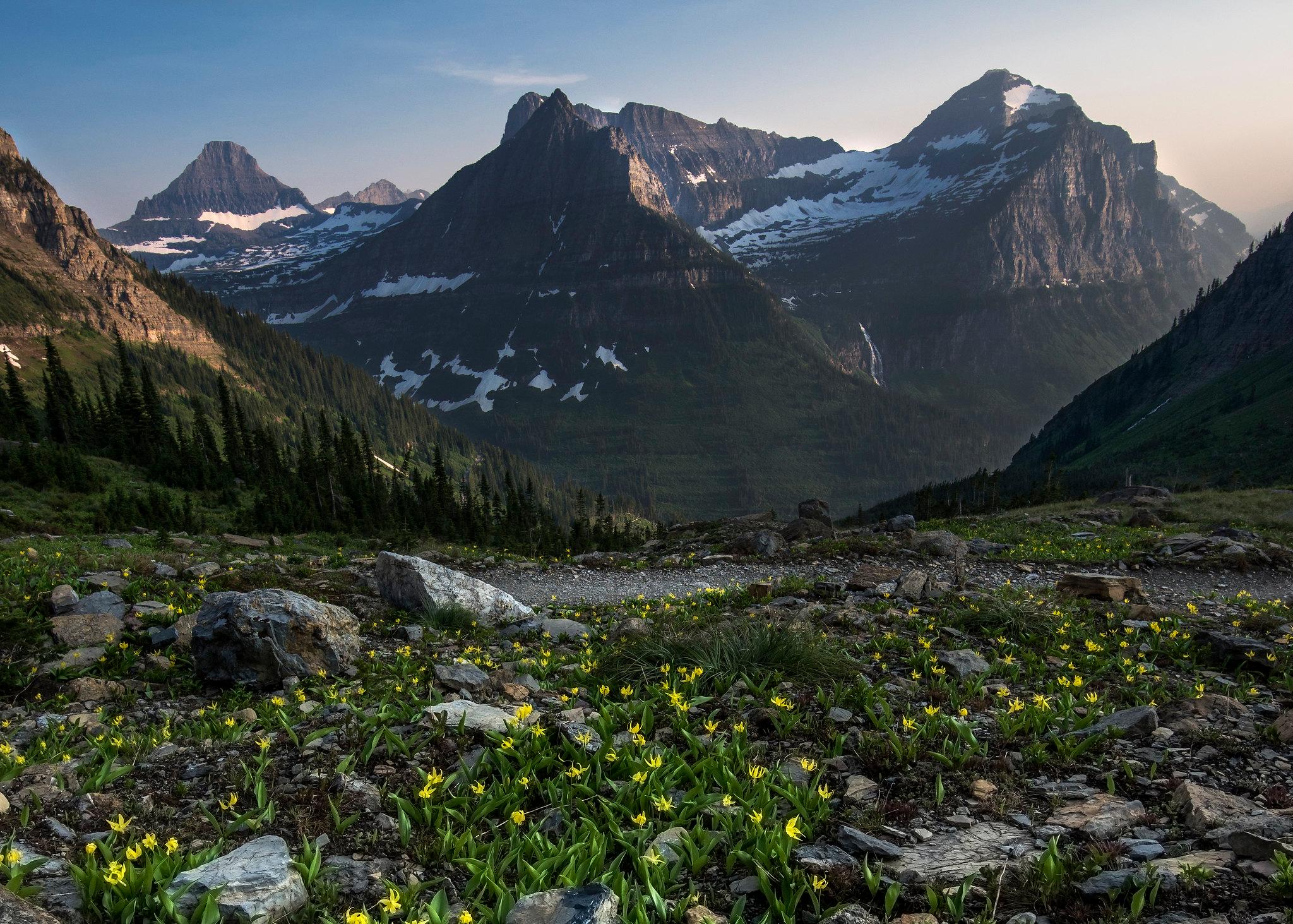
A showcase of melting glaciers, alpine meadows, carved valleys, and spectacular lakes. With over 700 miles of trails, Glacier is a paradise for adventurous visitors seeking a landscape steeped in huma...

14 mi from route ~34 min detour $35 near mile 21.6
Park Closure: Going-to-the-Sun Road Seasonal Closure
View on nps.gov

Park data from the National Park Service API. Alerts update every 2 hours.

Fuel & Cost

Regular Gas

$49.71 one way

$99.42 round trip

$4.03/gal 25.4 MPG avg 110 kg CO2
Fuel Type $/gal One Way Round Trip
midgrade $4.22 $52.11 $104.21
premium $4.53 $55.96 $111.92
diesel $5.61 $69.26 $138.52

No toll roads detected on this route.

Estimated Trip Cost (one way, 1 person)

Fuel

$50

Meals

$25–$50

Total

$75–$100

Rough estimate based on US averages. Hotel $80–$140/night, meals $25–$50/day.

Estimated CO2 emission: 109.8 kg one way. Prices: EIA weekly data, 2026-04-13.

Driving Electric?

About $33 in charging · 1 stop · 66% less CO2

Vehicle Type kWh Stops DC Fast Home Charge
Average EV 94.1 1 $32.94 $15.06
Efficient EV 78.4 0 $27.45 $12.55
EV Truck/SUV 125.5 1 $43.92 $20.08

Gas CO2

110 kg

EV CO2

37 kg (66% less)

Plan for 1 charging stop. A 30-minute DC fast charge mid-route should be enough to complete the trip comfortably.

DC fast charging avg $0.35/kWh. Home charging avg $0.16/kWh. US grid CO2: 0.39 kg/kWh.

Travel Intel

Current conditions at both ends of the drive.

Forecast data refreshed 18 hours ago

Origin

Columbia Falls, MT

Late night in Columbia Falls on Wednesday

Local time

3:44 AM

MDT

Current temp

38°F

Unavailable

Live forecast

Destination

Lewistown, MT

Late night in Lewistown on Wednesday

Local time

3:44 AM

MDT

Current temp

65°F

Unavailable

Live forecast

Seasonal Notes

Summer travel usually means heavier construction, hotter rest stops, and busier weekend traffic around major cities.

Winter travel shortens daylight, so a route that looks manageable on paper can feel much longer after dark.

Holiday weekends tend to make both departure and arrival windows slower than the raw route time suggests.

Time zone

Same local time

Origin and destination are on the same clock, so arrival timing is easier to judge at a glance.

Temperature spread

27 degrees warmer at arrival

A meaningful temperature swing is a good cue to rethink layers, water, and how soon you want to arrive.

Road read

5h 56m on the road

An early start around 7-8 AM gets you there with plenty of daylight left.

Weather data from the National Weather Service. Conditions may change; check closer to your travel date.

Frequently Asked Questions

The drive from Columbia Falls, MT to Lewistown, MT covers 313.7 miles and takes about 5h 56m without stops. Add 15-30 minutes for a fuel or rest stop on longer drives.
The main roads are US Route 2, US 87, US 89. Most of the drive stays on highways, so watch for ramps and exits.
This is a comfortable same-day trip.
The midpoint is about 156.8 miles from Columbia Falls, MT. Look for rest areas, gas stations, or food options near the halfway mark.
At current regular gas prices, expect to spend about $49.71 one way. This estimate uses 25.4 MPG — your actual cost will vary with your vehicle's fuel efficiency and current gas prices.
An early start around 7-8 AM gets you there with plenty of daylight left. A late afternoon start means arriving after dark. Morning is better.
Plan about 1 meaningful break for fuel, food, or rest. Plan on a short reset every 3 to 4 hours to stay fresh behind the wheel.
This is a straightforward 5h 56m drive. You will face about 12 decision points, but nothing that requires special attention if you follow navigation.
The main spots that need attention: near the start (MT 486 / Nucleus Avenue): Navigation decision point; at 0.2 miles (US 2 / 9th Street): Navigation decision point; at 83.6 miles (US 2; US 89): Roundabout - know your exit number before entering.
The route from Columbia Falls, MT to Lewistown, MT does not surface many named destination signs beyond the main corridor.

Was this route helpful?

Thanks for your feedback!

Your tip has been submitted. Thanks!

/500

Explore More

Explore more options from Columbia Falls, MT or browse trips ending in Lewistown, MT.

Looking for more statewide routes? Browse MT road trips.

Explore maps for Columbia Falls, MT or Lewistown, MT on MapSof.net.