Trip from Columbus, GA to Isle of Hope, GA

Drive Time

5h 5m

Distance

253.1 mi

407 km

Drive Score

8/10

Great drive

Same Day?

Yes, doable

Fuel Cost

$41

one way

EV Charging

Loading...

station data

Best Time to Leave

Save up to 41 min
4 AM
4h 52m ★
6 AM
5h 6m
8 AM
5h 33m
10 AM
5h 15m
12 PM
5h 13m
3 PM
5h 17m
5 PM
5h 32m
8 PM
4h 58m

Estimated drive times based on typical traffic patterns. Actual times may vary with weather, construction, and real-time conditions.

Downtown Isle of Hope, GA, GA

Isle of Hope, GA

Valentine Kulikov

Trip Overview

The drive from Columbus, GA to Isle of Hope, GA covers 253.1 miles and takes about 5h 5m behind the wheel. This route is realistic as a one-day drive if you keep your stops efficient.

The route leans on Jim Gillis Historic Savannah Parkway, GA 96, Macon Road for much of the mileage, and the overall profile is highway-focused drive. The longest uninterrupted segment is about 135.2 miles on Jim Gillis Historic Savannah Parkway. At current regular gas prices, budget about $40.51 one way before food or hotel costs.

Trip Pace

Same-day drive is realistic

A same-day return is possible, but it will make for a full day on the road.

Break Rhythm

1 planned break

Plan on a short reset every 3 to 4 hours to stay fresh behind the wheel.

Midpoint

126.5 miles from Columbus, GA

A natural place for your longest stop of the day , about 2h 43m into the drive .

Drive Character

This is a 5h 5m highway drive covering 253.1 miles, with most of the trip on Jim Gillis Historic Savannah Parkway and GA 96. The longest continuous stretch is about 135.2 miles on Jim Gillis Historic Savannah Parkway.

Most of the miles stay on highways, which makes pacing and fuel planning easier than turn-by-turn city driving.
There are about 39 navigation steps in the underlying route data, so the final approach matters more than the middle miles.
Jim Gillis Historic Savannah Parkway is the longest continuous segment at about 135.2 miles.

How Hard Is This Drive?

This is a straightforward highway drive that stays mostly on Jim Gillis Historic Savannah Parkway and GA 96. This route has several spots where lane changes, forks, or exits need your full attention. The trickiest moment comes around 0.7 miles in near 10th Avenue.

Route Complexity 7/10

Demanding - plan breaks and stay ahead of the key maneuvers

This is a demanding drive. With 18 significant decision points across 253.1 miles, you will need to stay alert — especially through interchange areas and urban stretches. Consider splitting it into segments if you are not comfortable with fast highway navigation.

Where does it get tricky?

The main spots that need attention: at 0.7 miles (10th Avenue): Lane positioning matters here; at 0.8 miles (Wynnton Road): Sharp turn - reduce speed on approach. Lane positioning matters here; at 71.4 miles (GA 96): Lane positioning matters here.

Critical Maneuvers

5 of 18 key points

These are the spots where you need to pay the most attention. Preview them before you drive.

6
0.7 mi into trip | ~1m in | 10th Avenue

Turn left onto 10th Avenue

Lane positioning matters here

Use the left lane.
7
0.8 mi into trip | ~2m in | Wynnton Road

Turn sharp right onto Wynnton Road

Sharp turn - reduce speed on approach. Lane positioning matters here

Use the straight / right lanes.
6
71.4 mi into trip | ~1h 31m in | GA 96

Turn left onto GA 96

Lane positioning matters here

Use the left lane.
8
242.7 mi into trip | ~4h 49m in

Take the exit toward I 516 East, US 80 East, US 17 South, GA 21 South: Lynes Parkway

Exit ramp - move to the correct lane early. Lane positioning matters here. Multiple destination signs - pick the right one

Use the straight / slight right lanes. Exit 164A Toward I 516 East, US 80 East, US 17 South, GA...
8
242.8 mi into trip | ~4h 49m in

Keep slight right at fork toward I 516 East, US 80 East, US 17 South, GA 21 South: Lynes Parkway

Highway fork - watch signs carefully. Multiple destination signs - pick the right one

Exit 164A Toward I 516 East, US 80 East, US 17 South, GA...

Towns Along This Route

On the drive from Columbus, GA to Isle of Hope, GA, road signs begin pointing toward Savannah along the way.

Savannah

107.4 mi in | ~2h 23m | via I 16

Main Roads

Road Distance Duration
Jim Gillis Historic Savannah Parkway 135.2 mi 2h 25m
GA 96 65.2 mi 1h 24m
Macon Road 25.3 mi 32m
Miami Valley Road 7.3 mi 9m
William F. Lynes Parkway 4 mi 5m
GA 358 3.6 mi 4m
Harry Truman Parkway 1.8 mi 2m
West Derenne Avenue 1.6 mi 2m
Longest stretch: Jim Gillis Historic Savannah Parkway — 135.2 mi, about 2h 25m

Turn-by-Turn Driving Directions

Step-by-step road directions between Columbus, GA and Isle of Hope, GA.

1

Start on Veterans Parkway

13 ft · 6 sec · Veterans Parkway
2

Continue on Veterans Parkway

0.3 mi · 47 sec · Veterans Parkway
3

Turn right onto 10th Street

0.5 mi · 1 min · 10th Street
4

Turn left onto 10th Avenue

404 ft · 16 sec · 10th Avenue
5

Turn sharp right onto Wynnton Road

1.6 mi · 2 min · Wynnton Road
6

Continue on Macon Road

8.0 mi · 12 min · Macon Road
7

Continue straight

0.2 mi · 16 sec
8

Turn right onto Beaver Run Road

0.2 mi · 14 sec · Beaver Run Road
9

Continue on Macon Road

17 mi · 20 min · Macon Road
10

Continue straight

0.8 mi · 1 min
11

Continue straight

39 mi · 46 min
12

Turn right

2.7 mi · 3 min
13

Continue on Orange Street

351 ft · 11 sec · Orange Street
14

Continue on Vineville Street

0.6 mi · 1 min · Vineville Street
15

Turn right onto Oakland Heights Parkway

0.1 mi · 25 sec · Oakland Heights Parkway
16

Turn left

0.2 mi · 36 sec
17

Continue on East Church Street

1.2 mi · 2 min · East Church Street
18

Continue on Miami Valley Road

7.3 mi · 9 min · Miami Valley Road
19

Continue straight

2.8 mi · 3 min
20

Continue straight

0.3 mi · 28 sec
21

Continue straight

1.6 mi · 2 min
22

Continue straight

2.2 mi · 3 min
23

Continue straight

1.2 mi · 1 min
24

Continue straight

15 mi · 20 min
25

Turn right

3.6 mi · 4 min
26

Take the ramp slight right

0.6 mi · 1 min
27

Merge slight left onto Jim Gillis Historic Savannah Parkway

135 mi · 2 hr 25 min · Jim Gillis Historic Savannah Parkway
28

Take the exit slight right toward I 516 East, US 80 East, US 17 South, GA 21 South: Lynes Parkway

0.1 mi · 16 sec · I 516 East, US 80 East, US 17 South, GA 21 South: Lynes Parkway
29

Keep slight right to continue on I 516 East, US 80 East, US 17 South, GA 21 South: Lynes Parkway

0.3 mi · 32 sec · I 516 East, US 80 East, US 17 South, GA 21 South: Lynes Parkway
30

Merge slight left onto William F. Lynes Parkway

4.0 mi · 5 min · William F. Lynes Parkway
31

Continue on West Derenne Avenue

1.6 mi · 2 min · West Derenne Avenue
32

Take the exit right toward Harry Truman Parkway South

0.4 mi · 48 sec · Harry Truman Parkway South
33

Merge slight left onto Harry Truman Parkway

1.8 mi · 2 min · Harry Truman Parkway
34

Take the exit slight right toward Montgomery Cross Road

0.3 mi · 37 sec · Montgomery Cross Road
35

Turn left onto East Montgomery Cross Road

0.5 mi · 57 sec · East Montgomery Cross Road
36

Turn right onto Skidaway Road

1.1 mi · 2 min · Skidaway Road
37

Continue on Parkersburg Road

0.3 mi · 54 sec · Parkersburg Road
38

Turn sharp left onto Central Avenue

463 ft · 16 sec · Central Avenue
39

Arrive at your destination

Trip Plan

Morning Departure

An early start around 7-8 AM gets you there with plenty of daylight left.

Evening Departure

A late afternoon start means arriving after dark. Morning is better.

You can normally do this drive in one day.
Plan roughly 1 meaningful break for fuel, food, and rest.
The halfway point lands around 126.5 miles from Columbus, GA, or about 2h 43m into the drive.
The longest continuous stretch on this route runs about 135.2 miles.

This is a comfortable same-day trip.

Departure

Before you leave

Start with fuel, water, and navigation already sorted so the first hour feels easy.

First stop

Around 80 miles or 1h 44m in

Use this first pause for coffee, a restroom break, and a quick traffic check ahead.

Halfway reset

Around 126.5 miles or 2h 43m in

This is the best place for your longest stop, a real meal, and a full fuel check.

Final approach

Final hour starts around 4h 11m

Traffic, exits, and arrival timing usually matter more near Isle of Hope, GA than in the middle of the route.

Before You Leave

+

Open the route before leaving Columbus, GA so your first major turns are already loaded.

+

Leave with enough water and a charging cable within reach, not packed away.

+

Check your fuel range against the first long segment, especially if you are starting outside city service areas.

Day 1

Settle into the route from Columbus, GA

This is one driving day of about 253.1 miles and 5h 5m.

Your first comfortable stop window is around 80 miles from Columbus, GA.
This route can stay practical as a one-day drive if traffic stays reasonable.
Plan about 1 real break rather than only quick fuel stops.
The longest stretch is on Jim Gillis Historic Savannah Parkway for about 135.2 miles.

Where to Stop

Rest stops, refuel points, and overnight suggestions along this route.

Halfway Point

Midpoint

About 126.5 mi from Columbus, GA · 2h 43m into the drive

Downtown Dadeville, AL, AL

Mid-route town

Meal stop

Dadeville, AL

127 mi into the route

Best for: Lunch, fuel, and a longer reset

This sits close to the middle of the route, so it works well for the longest stop of the day.

Pacing Suggestions

Dadeville, AL

Fuel and coffee

A short stop after about 80 miles helps settle the day before fatigue starts building.

Dadeville, AL

Meal break

The midpoint is around 126.5 miles from Columbus, GA, which is a good place for a longer meal and fuel stop.

Arriving in Isle of Hope, GA

The final approach into Isle of Hope, GA usually feels slower than the middle of the drive, so avoid planning your tightest schedule at the very end.

Try to arrive with enough fuel left to skip an immediate station stop unless you already know the area around Isle of Hope, GA.

After long uninterrupted mileage, take five minutes before the last urban segment to reset and refocus on exits, merges, and city traffic.

These stop ideas are pacing suggestions — the exact town or exit can change with traffic, hotel plans, and fuel range.

National Parks Near This Route

Worth a detour if your schedule allows.

Fort Pulaski National Monument

Fort Pulaski National Monument

National Monument

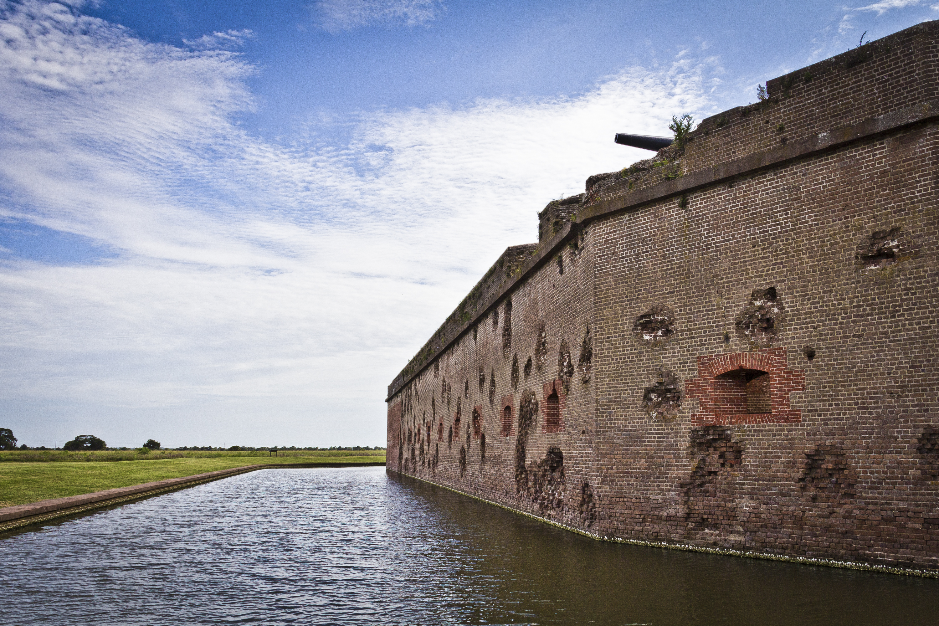
For much of the 19th century, masonry fortifications were the United States’ main defense against overseas enemies. However, during the Civil War, new technology proved its superiority over these fort...

8 mi from route ~20 min detour $10 near mile 253.1
View on nps.gov
Ocmulgee Mounds National Historical Park

Ocmulgee Mounds National Historical Park

National Historical Park

Welcome to Ocmulgee Mounds National Historical Park. This park is a prehistoric American Indian site, where many different American Indian cultures occupied this land for thousands of years. American...

20 mi from route ~49 min detour Free near mile 87.3
View on nps.gov

Park data from the National Park Service API. Alerts update every 2 hours.

Fuel & Cost

Regular Gas

$40.51 one way

$81.01 round trip

$4.07/gal 25.4 MPG avg 89 kg CO2
Fuel Type $/gal One Way Round Trip
midgrade $4.43 $44.13 $88.27
premium $4.78 $47.61 $95.22
diesel $5.64 $56.23 $112.46

No toll roads detected on this route.

Estimated Trip Cost (one way, 1 person)

Fuel

$41

Meals

$25–$50

Total

$66–$91

Rough estimate based on US averages. Hotel $80–$140/night, meals $25–$50/day.

Estimated CO2 emission: 88.6 kg one way. Prices: EIA weekly data, 2026-04-06.

Driving Electric?

About $27 in charging · 0 stops · 66% less CO2

Vehicle Type kWh Stops DC Fast Home Charge
Average EV 75.9 0 $26.58 $12.15
Efficient EV 63.3 0 $22.15 $10.12
EV Truck/SUV 101.2 1 $35.43 $16.20

Gas CO2

89 kg

EV CO2

30 kg (66% less)

Plan for 0 charging stops, roughly every 270 miles. Allow 25-40 minutes per stop at a DC fast charger.

DC fast charging avg $0.35/kWh. Home charging avg $0.16/kWh. US grid CO2: 0.39 kg/kWh.

Travel Intel

Current conditions at both ends of the drive.

Forecast data refreshed 1 day ago

Origin

Columbus, GA

Late night in Columbus on Monday

Local time

5:22 AM

EDT

Current temp

61°F

Unavailable

Live forecast

Destination

Isle of Hope, GA

Late night in Isle of Hope on Monday

Local time

5:22 AM

EDT

Current temp

88°F

Unavailable

Live forecast

Seasonal Notes

Summer travel usually means heavier construction, hotter rest stops, and busier weekend traffic around major cities.

Winter travel shortens daylight, so a route that looks manageable on paper can feel much longer after dark.

Holiday weekends tend to make both departure and arrival windows slower than the raw route time suggests.

Time zone

Same local time

Origin and destination are on the same clock, so arrival timing is easier to judge at a glance.

Temperature spread

27 degrees warmer at arrival

A meaningful temperature swing is a good cue to rethink layers, water, and how soon you want to arrive.

Road read

5h 5m on the road

An early start around 7-8 AM gets you there with plenty of daylight left.

Weather data from the National Weather Service. Conditions may change; check closer to your travel date.

Frequently Asked Questions

The drive from Columbus, GA to Isle of Hope, GA covers 253.1 miles and takes about 5h 5m without stops. Add 15-30 minutes for a fuel or rest stop on longer drives.
The main roads are Jim Gillis Historic Savannah Parkway, GA 96, Macon Road. Most of the drive stays on highways, so watch for ramps and exits.
This is a comfortable same-day trip.
The midpoint is about 126.5 miles from Columbus, GA. Look for rest areas, gas stations, or food options near the halfway mark.
At current regular gas prices, expect to spend about $40.51 one way. This estimate uses 25.4 MPG — your actual cost will vary with your vehicle's fuel efficiency and current gas prices.
An early start around 7-8 AM gets you there with plenty of daylight left. A late afternoon start means arriving after dark. Morning is better.
Plan about 1 meaningful break for fuel, food, or rest. Plan on a short reset every 3 to 4 hours to stay fresh behind the wheel.
This is a demanding drive. With 18 significant decision points across 253.1 miles, you will need to stay alert — especially through interchange areas and urban stretches. Consider splitting it into segments if you are not comfortable with fast highway navigation.
The main spots that need attention: at 0.7 miles (10th Avenue): Lane positioning matters here; at 0.8 miles (Wynnton Road): Sharp turn - reduce speed on approach. Lane positioning matters here; at 71.4 miles (GA 96): Lane positioning matters here.
On the drive from Columbus, GA to Isle of Hope, GA, road signs begin pointing toward Savannah along the way.

Was this route helpful?

Thanks for your feedback!

Your tip has been submitted. Thanks!

/500

Explore More

More trips to Isle of Hope, GA

Explore more options from Columbus, GA or browse trips ending in Isle of Hope, GA.

Looking for more statewide routes? Browse GA road trips.

Explore maps for Columbus, GA or Isle of Hope, GA on MapSof.net.