Trip from Cutler Bay, FL to Brent, FL

Drive Time

12h 35m

Distance

692.7 mi

1,115 km

Drive Score

7/10

Good drive

Same Day?

2-day trip

Fuel Cost

$116

one way

EV Charging

None

0 DC fast

Best Time to Leave

Save up to 34 min
4 AM
12h 24m ★
6 AM
12h 35m
8 AM
12h 58m
10 AM
12h 43m
12 PM
12h 41m
3 PM
12h 44m
5 PM
12h 57m
8 PM
12h 28m

Estimated drive times based on typical traffic patterns. Actual times may vary with weather, construction, and real-time conditions.

Downtown Cutler Bay, FL, FL

Cutler Bay, FL

DΛVΞ GΛRCIΛ

Downtown Brent, FL, FL

Brent, FL

DΛVΞ GΛRCIΛ

Trip Overview

The drive from Cutler Bay, FL to Brent, FL covers 692.7 miles and takes about 12h 35m behind the wheel. It usually feels better as a 2-day road trip than as one long push.

The route leans on I 10, Florida's Turnpike, I 75 for much of the mileage, and the overall profile is long-distance drive. The longest uninterrupted segment is about 283.4 miles on I 10. At current regular gas prices, budget about $115.71 one way before food or hotel costs.

Trip Pace

Best split across 2 days

Treat the return leg as its own travel day rather than an afterthought.

Break Rhythm

3 planned breaks

Plan on a short reset every 3 to 4 hours to stay fresh behind the wheel.

Midpoint

346.3 miles from Cutler Bay, FL

A natural place for your longest stop of the day , about 6h 21m into the drive .

Drive Character

At 692.7 miles and 12h 35m of driving, this is a route where fuel stops, weather, and timing matter more than any single turn. The main roads are I 10 and Florida's Turnpike.

Most of the miles stay on highways, which makes pacing and fuel planning easier than turn-by-turn city driving.
There are about 28 navigation steps in the underlying route data, so the final approach matters more than the middle miles.
I 10 is the longest continuous segment at about 283.4 miles.

How Hard Is This Drive?

This is a straightforward highway drive that stays mostly on I 10 and Florida's Turnpike. This route has several spots where lane changes, forks, or exits need your full attention. The trickiest moment comes around 37 miles in near Homestead Extension of Florida's Turnpike.

Route Complexity 10/10

High effort - long or complex enough to need steady focus all day

This is a demanding drive. With 23 significant decision points across 692.7 miles, you will need to stay alert — especially through interchange areas and urban stretches. Consider splitting it into segments if you are not comfortable with fast highway navigation.

Where does it get tricky?

The main spots that need attention: at 37 miles (Homestead Extension of Florida's Turnpike): Highway fork - watch signs carefully. Lane positioning matters here. Multiple destination signs - pick the right one; at 405.7 miles: Exit ramp - move to the correct lane early. Lane positioning matters here. Multiple destination signs - pick the right one; at 405.9 miles: Highway fork - watch signs carefully. Lane positioning matters here.

Critical Maneuvers

5 of 23 key points

These are the spots where you need to pay the most attention. Preview them before you drive.

8
37 mi into trip | ~45m in | Homestead Extension of Florida's Turnpike

Keep slight right at fork onto Homestead Extension of Florida's Turnpike toward Orlando, Florida's Turnpike Toll North

Highway fork - watch signs carefully. Lane positioning matters here. Multiple destination signs - pick the right one

Use the straight / slight left lanes. Toward Orlando, Florida's Turnpike Toll North
8
405.7 mi into trip | ~7h 25m in

Take the exit toward I 10: Jacksonville, Tallahassee

Exit ramp - move to the correct lane early. Lane positioning matters here. Multiple destination signs - pick the right one

Use the straight / slight right lanes. Exit 435 Toward I 10: Jacksonville, Tallahassee
8
405.9 mi into trip | ~7h 25m in

Keep slight left at fork toward I 10 West: Tallahassee

Highway fork - watch signs carefully. Lane positioning matters here

Use the slight left / slight right lanes. Toward I 10 West: Tallahassee
8
689.6 mi into trip | ~12h 29m in

Take the exit toward I 110 South: Pensacola, Pensacola Beach

Exit ramp - move to the correct lane early. Lane positioning matters here. Multiple destination signs - pick the right one

Use the straight / slight right lanes. Exit 12 Toward I 110 South: Pensacola, Pensacola Beach
8
690.9 mi into trip | ~12h 31m in

Take the exit toward FL 750, FL 296: Airport Boulevard, Brent Lane

Exit ramp - move to the correct lane early. Lane positioning matters here. Multiple destination signs - pick the right one

Use the straight / slight right lanes. Exit 5 Toward FL 750, FL 296: Airport Boulevard, Brent...

Towns Along This Route

Between Cutler Bay, FL and Brent, FL, road signs point toward Orlando, Florida's Turnpike Toll North and Tallahassee.

Orlando

37 mi in | ~45m | via Homestead Extension of Florida's Turnpike

Florida's Turnpike Toll North

37 mi in | ~45m | via Homestead Extension of Florida's Turnpike

Tallahassee

405.7 mi in | ~7h 25m

Main Roads

Road Distance Duration
I 10 283.4 mi 5h 3m
Florida's Turnpike 260.8 mi 4h 43m
I 75 106.9 mi 1h 54m
Homestead Extension of Florida's Turnpike 35.5 mi 40m
Old Cutler Road 1.2 mi 2m
Southwest 216th Street 0.6 mi 1m
East Frontage Road 0.5 mi 1m
Reubin O'Donovan Askew Parkway 0.4 mi <1m
Longest stretch: I 10 — 283.4 mi, about 5h 3m

Turn-by-Turn Driving Directions

Step-by-step road directions between Cutler Bay, FL and Brent, FL.

1

Start on this road

116 ft · 14 sec · this road
2

Turn left

76 ft · 7 sec
3

Turn right onto Old Cutler Road

0.7 mi · 1 min · Old Cutler Road
4

Enter roundabout onto Old Cutler Road

80 ft · 1 sec · Old Cutler Road
5

Continue on Old Cutler Road

0.4 mi · 1 min · Old Cutler Road
6

Turn right onto Southwest 216th Street

0.6 mi · 1 min · Southwest 216th Street
7

Turn right onto East Frontage Road

0.5 mi · 1 min · East Frontage Road
8

Take the ramp

0.2 mi · 24 sec
Toward Florida's Turnpike North: Orlando Use the left lane.
9

Merge onto Homestead Extension of Florida's Turnpike

1.3 mi · 1 min · Homestead Extension of Florida's Turnpike
Use the straight / slight right lanes.
10

Keep slight right at fork onto Homestead Extension of Florida's Turnpike

3.6 mi · 4 min · Homestead Extension of Florida's Turnpike
Use the straight / slight right lanes.
11

Keep slight left at fork onto Homestead Extension of Florida's Turnpike

2.5 mi · 3 min · Homestead Extension of Florida's Turnpike
Use the straight / slight right lanes.
12

Keep slight right at fork onto Homestead Extension of Florida's Turnpike

27 mi · 30 min · Homestead Extension of Florida's Turnpike
Use the straight / slight right lanes.
13

Keep slight right at fork onto Homestead Extension of Florida's Turnpike

1.0 mi · 1 min · Homestead Extension of Florida's Turnpike
Toward Orlando, Florida's Turnpike Toll North Use the straight / slight left lanes.
14

Merge onto Florida's Turnpike

261 mi · 4 hr 43 min · Florida's Turnpike
Use the straight / slight right lanes.
15

Keep slight left at fork onto Florida's Turnpike

0.2 mi · 15 sec · Florida's Turnpike
Toward I 75 North: Ocala Use the straight lane.
16

Merge onto I 75

107 mi · 1 hr 54 min · I 75
Use the straight / slight right lanes.
17

Take the exit

0.2 mi · 15 sec
Exit 435 Toward I 10: Jacksonville, Tallahassee Use the straight / slight right lanes.
18

Keep slight left at fork

0.3 mi · 30 sec
Toward I 10 West: Tallahassee Use the slight left / slight right lanes.
19

Merge onto I 10

283 mi · 5 hr 3 min · I 10
Use the straight / slight right lanes.
20

Take the exit

0.9 mi · 1 min
Exit 12 Toward I 110 South: Pensacola, Pensacola Beach Use the straight / slight right lanes.
21

Merge onto I 110

0.4 mi · 29 sec · Reubin O'Donovan Askew Parkway
22

Take the exit

0.2 mi · 22 sec
Exit 5 Toward FL 750, FL 296: Airport Boulevard, Brent Lane Use the straight / slight right lanes.
23

Keep slight left at fork

1.0 mi · 1 min
Toward FL 296: Brent Lane Use the straight / slight right lanes.
24

Turn right onto FL 296

0.3 mi · 52 sec · Brent Lane
25

Continue on East Brent Lane

0.1 mi · 29 sec · East Brent Lane
26

Turn left onto Sycamore Drive

218 ft · 12 sec · Sycamore Drive
27

Turn left onto East Brent Lane

34 ft · 1 sec · East Brent Lane
28

Arrive at destination

East Brent Lane

Trip Plan

Morning Departure

Start early — leave by 6-7 AM to arrive at a reasonable hour.

Evening Departure

This is a long drive — plan for a morning departure or consider splitting it into two days.

This drive is better paced as a 2-day trip.
Plan roughly 3 meaningful breaks for fuel, food, and rest.
The halfway point lands around 346.3 miles from Cutler Bay, FL, or about 6h 21m into the drive.
The longest continuous stretch on this route runs about 283.4 miles.

Consider an overnight stop or starting very early.

Departure

Before you leave

Start with fuel, water, and navigation already sorted so the first hour feels easy.

First stop

Around 152 miles or 2h 50m in

Use this first pause for coffee, a restroom break, and a quick traffic check ahead.

Halfway reset

Around 346.3 miles or 6h 21m in

This is the best place for your longest stop, a real meal, and a full fuel check.

Overnight split

Day 1 wrap after about 346.3 miles or 6h 21m

Stop before fatigue turns the last few hours into a grind. You want day two to start fresh, not just resumed.

Final approach

Final hour starts around 11h 28m

Traffic, exits, and arrival timing usually matter more near Brent, FL than in the middle of the route.

Before You Leave

+

Open the route before leaving Cutler Bay, FL so your first major turns are already loaded.

+

Leave with enough water and a charging cable within reach, not packed away.

+

Check your fuel range against the first long segment, especially if you are starting outside city service areas.

+

Pick one backup stop option before the midpoint in case traffic changes your pacing.

+

Treat this as a 2-day road trip and book the overnight stop before the busiest arrival window.

Day 1

Settle into the route from Cutler Bay, FL

Aim for roughly 346 miles and 6.3 hours of wheel time on this day.

Day 2

Finish the approach into Brent, FL

Aim for roughly 346 miles and 6.3 hours of wheel time on this day.

Your first comfortable stop window is around 152 miles from Cutler Bay, FL.
This route usually feels better as a 2-day drive than as one long push.
Plan about 3 real breaks rather than only quick fuel stops.
The longest stretch is on I 10 for about 283.4 miles.

Where to Stop

Rest stops, refuel points, and overnight suggestions along this route.

Halfway Point

Midpoint

About 346.3 mi from Cutler Bay, FL · 6h 21m into the drive

First major stop

Coffee and fuel

Port Saint Lucie, FL

229 mi into the route

Best for: Coffee, fuel, and an easy first stretch

This is a natural early stop once the first hours of the drive are behind you.

Popular next leg

Port Saint Lucie, FL to Brent, FL

562.4 mi · 10h 8m

Downtown Lake City, FL, FL

Second major stop

Overnight candidate

Lake City, FL

457 mi into the route

Best for: Hotel check-in, dinner, and a fresh start

This lines up well with a realistic day-end stop if you are breaking the drive into stages.

Find hotels in Lake City, FL

Overnight Options

Night 1

Orlando, FL

346 mi · about 6.3h in

A practical overnight split lands near Orlando, FL after about 346 miles or 6.3 hours of driving.

Find hotels

Pacing Suggestions

Port Saint Lucie, FL

Fuel and coffee

A short stop after about 152 miles helps settle the day before fatigue starts building.

Gainesville, FL

Meal break

The midpoint is around 346.3 miles from Cutler Bay, FL, which is a good place for a longer meal and fuel stop.

Before the longest stretch

Fuel check

Top up before I 10 if your tank is already low. That segment runs about 283.4 miles.

Overnight split

Hotel stop

For a steadier pace, wrap day one after about 346 miles or 6.3 hours on the road.

Arriving in Brent, FL

The final approach into Brent, FL usually feels slower than the middle of the drive, so avoid planning your tightest schedule at the very end.

Try to arrive with enough fuel left to skip an immediate station stop unless you already know the area around Brent, FL.

On a multi-day trip, keep the last day a little lighter so you reach Brent, FL with some flexibility left in the schedule.

After long uninterrupted mileage, take five minutes before the last urban segment to reset and refocus on exits, merges, and city traffic.

These stop ideas are pacing suggestions — the exact town or exit can change with traffic, hotel plans, and fuel range.

National Parks Near This Route

Worth a detour if your schedule allows.

Biscayne National Park

Biscayne National Park

National Park

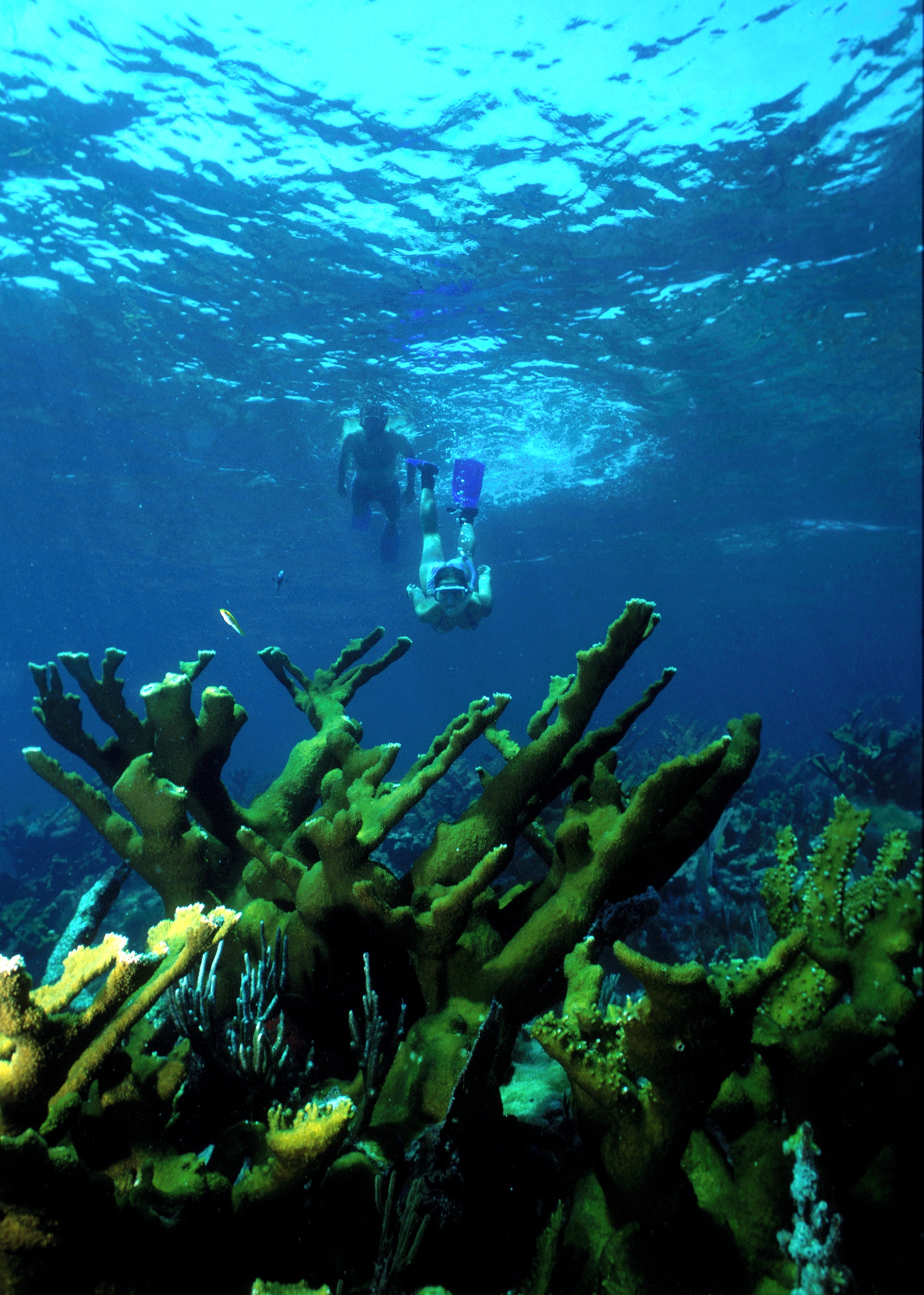
Within sight of Miami, yet worlds away, Biscayne protects a rare combination of aquamarine waters, emerald islands, and fish-bejeweled coral reefs. Evidence of 10,000 years of human history is here to...

10 mi from route ~25 min detour Free
Caution: Boater Awareness
View on nps.gov
Gulf Islands National Seashore

Gulf Islands National Seashore

National Seashore

Millions of visitors are drawn to the Gulf of America for Gulf Islands National Seashore's emerald coast waters, magnificent white beaches, fertile marshes and historical landscapes. Come explore with...

10 mi from route ~26 min detour $25 near mile 692.7
View on nps.gov

Park data from the National Park Service API. Alerts update every 2 hours.

Fuel & Cost

Regular Gas

$115.71 one way

$231.43 round trip

$4.24/gal 25.4 MPG avg 242 kg CO2
Fuel Type $/gal One Way Round Trip
midgrade $4.60 $125.34 $250.68
premium $4.90 $133.52 $267.04
diesel $5.64 $153.89 $307.79

Estimated Tolls: $20.37

Florida's Turnpike (260.5 mi) $18.24
Homestead Extension (35.5 mi) $2.13

Toll estimates based on average 2024-2025 rates. EZ-Pass/SunPass discounts may lower the actual cost.

Estimated Trip Cost (one way, 1 person)

Fuel

$116

Tolls

$20

Hotel (1n)

$80–$140

Meals

$50–$100

Total

$266–$376

Rough estimate based on US averages. Hotel $80–$140/night, meals $25–$50/day.

Estimated CO2 emission: 242.4 kg one way. Prices: EIA weekly data, 2026-04-06.

Driving Electric?

About $73 in charging · 2 stops · 67% less CO2

Vehicle Type kWh Stops DC Fast Home Charge
Average EV 207.8 2 $72.73 $33.25
Efficient EV 173.2 1 $60.61 $27.71
EV Truck/SUV 277.1 3 $96.98 $44.33

Gas CO2

242 kg

EV CO2

81 kg (67% less)

Plan for 2 charging stops, roughly every 270 miles. Allow 25-40 minutes per stop at a DC fast charger.

DC fast charging avg $0.35/kWh. Home charging avg $0.16/kWh. US grid CO2: 0.39 kg/kWh.

Travel Intel

Current conditions at both ends of the drive.

Forecast data refreshed 1 day ago

Origin

Cutler Bay, FL

Afternoon in Cutler Bay on Monday

Local time

1:52 PM

EDT

Current temp

70°F

Unavailable

Live forecast

Destination

Brent, FL

Afternoon in Brent on Monday

Local time

12:52 PM

CDT

Current temp

65°F

Unavailable

Live forecast

Seasonal Notes

Summer travel usually means heavier construction, hotter rest stops, and busier weekend traffic around major cities.

Winter travel shortens daylight, so a route that looks manageable on paper can feel much longer after dark.

Holiday weekends tend to make both departure and arrival windows slower than the raw route time suggests.

For long drives, weather on day two can matter just as much as conditions at departure, so check the whole travel window rather than only the first day.

Time zone

1 hour earlier

The destination clock does not match departure time, so double-check hotel check-in windows and late arrival plans.

Temperature spread

5 degrees cooler at arrival

A meaningful temperature swing is a good cue to rethink layers, water, and how soon you want to arrive.

Road read

12h 35m on the road

This is long enough that the arrival forecast matters almost as much as departure conditions. Recheck both ends before you roll.

Weather data from the National Weather Service. Conditions may change; check closer to your travel date.

Frequently Asked Questions

The drive from Cutler Bay, FL to Brent, FL covers 692.7 miles and takes about 12h 35m without stops. Add 15-30 minutes for a fuel or rest stop on longer drives.
The main roads are I 10, Florida's Turnpike, I 75. Expect a mix of highway and local road driving.
Consider an overnight stop or starting very early.
Yes. This route is usually more comfortable as a 2-day drive. A sensible stopping point is after roughly 346 miles on day one.
The midpoint is about 346.3 miles from Cutler Bay, FL. Look for rest areas, gas stations, or food options near the halfway mark.
At current regular gas prices, expect to spend about $115.71 one way. This estimate uses 25.4 MPG — your actual cost will vary with your vehicle's fuel efficiency and current gas prices.
Start early — leave by 6-7 AM to arrive at a reasonable hour. This is a long drive — plan for a morning departure or consider splitting it into two days.
Plan about 3 meaningful breaks for fuel, food, or rest. Plan on a short reset every 3 to 4 hours to stay fresh behind the wheel.
This is a demanding drive. With 23 significant decision points across 692.7 miles, you will need to stay alert — especially through interchange areas and urban stretches. Consider splitting it into segments if you are not comfortable with fast highway navigation.
The main spots that need attention: at 37 miles (Homestead Extension of Florida's Turnpike): Highway fork - watch signs carefully. Lane positioning matters here. Multiple destination signs - pick the right one; at 405.7 miles: Exit ramp - move to the correct lane early. Lane positioning matters here. Multiple destination signs - pick the right one; at 405.9 miles: Highway fork - watch signs carefully. Lane positioning matters here.
Between Cutler Bay, FL and Brent, FL, road signs point toward Orlando, Florida's Turnpike Toll North and Tallahassee.

Was this route helpful?

Thanks for your feedback!

Your tip has been submitted. Thanks!

/500

Explore More

Explore more options from Cutler Bay, FL or browse trips ending in Brent, FL.

Looking for more statewide routes? Browse FL road trips.

Explore maps for Cutler Bay, FL or Brent, FL on MapSof.net.