
Trip from East Flatbush, NY to Rome, NY

Last recalculated Apr 16, 2026

Drive Time

5h 21m

Distance

262.5 mi

422 km

Drive Score

9/10

Great drive

Same Day?

Yes, doable

Fuel Cost

$43

one way

EV Charging

Unknown

Best Time to Leave

Save up to 40 min
4 AM
5h 8m ★
6 AM
5h 21m
8 AM
5h 48m
10 AM
5h 31m
12 PM
5h 28m
3 PM
5h 32m
5 PM
5h 47m
8 PM
5h 13m

Estimated drive times based on typical traffic patterns. Actual times may vary with weather, construction, and real-time conditions.

neighborhood of Brooklyn, New York City, USA

East Flatbush, NY

Wikimedia Commons

Downtown Rome, NY, NY

Rome, NY

Renan Tagliaferro

Trip Overview

The drive from East Flatbush, NY to Rome, NY covers 262.5 miles and takes about 5h 21m behind the wheel. This route is realistic as a one-day drive if you keep your stops efficient.

The route leans on NY 17, New York State Thruway, NJ 17 for much of the mileage, and the overall profile is highway-focused drive. The longest uninterrupted segment is about 117.5 miles on NY 17. At current regular gas prices, budget about $43.21 one way before food or hotel costs.

Trip Pace

Same-day drive is realistic

A same-day return is possible, but it will make for a full day on the road.

Break Rhythm

1 planned break

Plan on a short reset every 3 to 4 hours to stay fresh behind the wheel.

Midpoint

131.2 miles from East Flatbush, NY

A natural place for your longest stop of the day , about 2h 47m into the drive .

Who Is This Route For?

Weekend Trip

Doable as a same-day drive at 5h 21m. Total distance: 262.5 miles.

Family Friendly

Moderate complexity with 1 natural rest stops along the way.

Solo Traveler

5h 21m drive, comfortable solo distance.

Drive Character

This is a 5h 21m highway drive covering 262.5 miles, with most of the trip on NY 17 and New York State Thruway. The longest continuous stretch is about 117.5 miles on NY 17.

Most of the miles stay on highways, which makes pacing and fuel planning easier than turn-by-turn city driving.
There are about 46 navigation steps in the underlying route data, so the final approach matters more than the middle miles.
NY 17 is the longest continuous segment at about 117.5 miles.

How Hard Is This Drive?

This is a straightforward highway drive that stays mostly on NY 17 and New York State Thruway. This route has several spots where lane changes, forks, or exits need your full attention. The trickiest moment comes around 4.9 miles in.

Driving Effort 10/10

High effort - long or complex enough to need steady focus all day

Balances navigation complexity with total wheel time.

This is a demanding drive. With 31 significant decision points across 262.5 miles, you will need to stay alert - especially through interchange areas and urban stretches. Consider splitting it into segments if you are not comfortable with fast highway navigation.

Where does it get tricky?

The main spots that need attention: at 4.9 miles: Highway fork - watch signs carefully. Lane positioning matters here. Multiple destination signs - pick the right one; at 7.2 miles: Highway fork - watch signs carefully. Lane positioning matters here. Multiple destination signs - pick the right one; at 8.6 miles: Exit ramp - move to the correct lane early. Lane positioning matters here. Multiple destination signs - pick the right one.

Critical Maneuvers

5 of 31 key points

These are the spots where you need to pay the most attention. Preview them before you drive.

9
4.9 mi into trip | ~10m in

Keep slight left at fork toward Hugh L Carey Tunnel, Manhattan

Highway fork - watch signs carefully. Lane positioning matters here. Multiple destination signs - pick the right one

Use the straight / slight right lanes. Exit 25 Toward Hugh L Carey Tunnel, Manhattan
8
7.2 mi into trip | ~15m in

Keep slight right at fork toward NY 9A North: West Street, Holland Tunnel, Lincoln Tunnel, George Washington Bridge

Highway fork - watch signs carefully. Lane positioning matters here. Multiple destination signs - pick the right one

Use the right lane. Toward NY 9A North: West Street, Holland Tunnel...
8
8.6 mi into trip | ~19m in

Take the exit toward I 78: Holland Tunnel, New Jersey

Exit ramp - move to the correct lane early. Lane positioning matters here. Multiple destination signs - pick the right one

Use the straight / left lanes. Toward I 78: Holland Tunnel, New Jersey
8
19.1 mi into trip | ~35m in

Keep slight left at fork toward NJ 17 North: Rutherford

Highway fork - watch signs carefully. Lane positioning matters here

Use the slight left / slight right lanes. Toward NJ 17 North: Rutherford
8
42.4 mi into trip | ~1h 5m in | NY 17

Keep slight left at fork onto NY 17 toward I 87 North, NY 17 North, New York State Thruway North: Albany

Highway fork - watch signs carefully. Lane positioning matters here. Multiple destination signs - pick the right one

Use the straight / slight right lanes. Toward I 87 North, NY 17 North, New York State...

Towns Mentioned on Route Signs

Based on OSRM destination-sign hints, not a full list of every settlement the road passes.

On the drive from East Flatbush, NY to Rome, NY, road signs begin pointing toward New York State Thruway North: Albany along the way.

New York State Thruway North: Albany

42.4 mi in | ~1h 5m | via NY 17

Main Roads

Road Distance Duration
NY 17 117.5 mi 2h 15m
New York State Thruway 85.1 mi 1h 38m
NJ 17 22.9 mi 28m
State Route 49 13.7 mi 16m
NJ 3 4.3 mi 5m
Tonnelle Avenue 2.6 mi 3m
Holland Tunnel 1.8 mi 3m
NY 49 1.4 mi 2m
Longest stretch: NY 17 — 117.5 mi, about 2h 15m

Turn-by-Turn Driving Directions

Step-by-step road directions between East Flatbush, NY and Rome, NY.

1

Start on NY 27

1.3 mi · 3 min · Linden Boulevard
2

Turn slight right onto NY 27

0.4 mi · 40 sec · Caton Avenue
3

Turn right onto Saint Pauls Place

0.2 mi · 51 sec · Saint Pauls Place
4

At end of road, turn left onto Parkside Avenue

0.5 mi · 53 sec · Parkside Avenue
5

Enter roundabout onto Fort Hamilton Parkway

266 ft · 5 sec · Fort Hamilton Parkway
6

Continue on Fort Hamilton Parkway

33 ft · 0 sec · Fort Hamilton Parkway
7

Keep slight right at fork onto Ocean Parkway

0.2 mi · 29 sec · Ocean Parkway
Toward Prospect Avenue, Prospect Expressway North
8

Take the ramp

0.1 mi · 19 sec
Toward NY 27 West: Prospect Expressway, Brooklyn-Queens Expressway
9

Merge onto NY 27

1.3 mi · 2 min · Prospect Expressway
Use the straight / slight right lanes.
10

Keep slight left at fork onto NY 27

0.4 mi · 46 sec · NY 27
Toward I 278 East: Queens, Bronx
11

Merge onto I 278

0.4 mi · 39 sec · Gowanus Expressway
12

Keep slight left at fork

2.3 mi · 4 min
Exit 25 Toward Hugh L Carey Tunnel, Manhattan Use the straight / slight right lanes.
13

Keep slight right at fork

230 ft · 10 sec
Toward NY 9A North: West Street, Holland Tunnel, Lincoln Tunnel, George Washington Bridge Use the right lane.
14

At end of road, turn right onto NY 9A

1.1 mi · 3 min · West Street
Use the right lane.
15

Turn right onto Vestry Street

0.2 mi · 47 sec · Vestry Street
16

Turn left onto Hudson Street

374 ft · 18 sec · Hudson Street
Use the straight / left lanes.
17

Take the exit

406 ft · 14 sec
Toward I 78: Holland Tunnel, New Jersey Use the straight / left lanes.
18

Merge onto I 78

1.8 mi · 3 min · Holland Tunnel
19

Continue on I 78

0.4 mi · 1 min · 14th Street
Use the straight / right lanes.
20

Keep slight left at fork onto NJ 139

0.3 mi · 24 sec · 14th Street Viaduct
Toward NJ 139 West: Pulaski Skyway, Kennedy Boulevard, Jersey City
21

Continue on NJ 139

0.8 mi · 1 min · NJ 139 Lower Level
22

Continue on NJ 139

406 ft · 7 sec · Pulaski Skyway
23

Take the exit

420 ft · 14 sec
Toward US 1-9 North: Secausus Use the straight / slight right lanes.
24

Turn right onto US 1; US 9

2.6 mi · 3 min · Tonnelle Avenue
Use the straight / right lanes.
25

Turn straight onto NJ 3

4.3 mi · 5 min · NJ 3
Use the straight / slight right lanes.
26

Take the exit

0.1 mi · 13 sec
Toward NJ 17 North: Rutherford Use the straight / slight right lanes.
27

Keep slight left at fork

0.3 mi · 35 sec
Toward NJ 17 North: Rutherford Use the slight left / slight right lanes.
28

Merge onto NJ 17

3.3 mi · 3 min · NJ 17
Use the straight / slight right lanes.
29

Continue on NJ 17

4.2 mi · 4 min · NJ 17
Use the straight / slight right lanes.
30

Continue on NJ 17

4.1 mi · 5 min · NJ 17
Use the straight / slight right lanes.
31

Continue on NJ 17

7.3 mi · 9 min · NJ 17
Use the straight / right lanes.
32

Continue on NJ 17

0.7 mi · 50 sec · NJ 17
33

Continue on NJ 17

3.3 mi · 4 min · NJ 17
34

Continue on I 287; NY 17

0.2 mi · 10 sec · I 287; NY 17
35

Keep slight left at fork onto NY 17

118 mi · 2 hr 15 min · NY 17
Toward I 87 North, NY 17 North, New York State Thruway North: Albany Use the straight / slight right lanes.
36

Keep slight left at fork onto I 90

85 mi · 1 hr 38 min · New York State Thruway
Toward I 90 West: Buffalo
37

Take the exit

0.8 mi · 1 min
Toward I 790, NY 8, NY 12: Utica Use the slight right lane.
38

Keep slight right at fork

0.2 mi · 24 sec
39

Continue on North Genesee Street

0.1 mi · 9 sec · North Genesee Street
40

Turn right onto Auert Avenue

327 ft · 4 sec · Auert Avenue
41

Take the exit

0.2 mi · 19 sec
42

Merge onto I 790; NY 5

0.7 mi · 50 sec · I 790; NY 5
43

Continue on NY 49

14 mi · 16 min · State Route 49
44

Take the exit onto NY 49; NY 69

1.4 mi · 2 min · NY 49; NY 69
45

Turn right onto NY 26

0.2 mi · 21 sec · North James Street
46

Arrive at destination

NY 26

Trip Plan

Morning Departure

An early start around 7-8 AM gets you there with plenty of daylight left.

Evening Departure

A late afternoon start means arriving after dark. Morning is better.

You can normally do this drive in one day.
Plan roughly 1 meaningful break for fuel, food, and rest.
The halfway point lands around 131.2 miles from East Flatbush, NY, or about 2h 47m into the drive.
The longest continuous stretch on this route runs about 117.5 miles.

This is a comfortable same-day trip.

Departure

Before you leave

Start with fuel, water, and navigation already sorted so the first hour feels easy.

First stop

Around 58 miles or 1h 23m in

Use this first pause for coffee, a restroom break, and a quick traffic check ahead.

Halfway reset

Around 131.2 miles or 2h 47m in

This is the best place for your longest stop, a real meal, and a full fuel check.

Final approach

Final hour starts around 4h 24m

Traffic, exits, and arrival timing usually matter more near Rome, NY than in the middle of the route.

Before You Leave

+

Open the route before leaving East Flatbush, NY so your first major turns are already loaded.

+

Leave with enough water and a charging cable within reach, not packed away.

+

Check your fuel range against the first long segment, especially if you are starting outside city service areas.

Day 1

Settle into the route from East Flatbush, NY

This is one driving day of about 262.5 miles and 5h 21m.

Your first comfortable stop window is around 58 miles from East Flatbush, NY.
This route can stay practical as a one-day drive if traffic stays reasonable.
Plan about 1 real break rather than only quick fuel stops.
The longest stretch is on NY 17 for about 117.5 miles.

Where to Stop

Rest stops, refuel points, and overnight suggestions along this route.

Halfway Point

Midpoint

About 131.2 mi from East Flatbush, NY · 2h 47m into the drive

town in Rockland County, New York, United States

Mid-route town

Meal stop

Ramapo, NY

131 mi into the route

Best for: Lunch, fuel, and a longer reset

This sits close to the middle of the route, so it works well for the longest stop of the day.

Pacing Suggestions

Ramapo, NY

Fuel and coffee

A short stop after about 58 miles helps settle the day before fatigue starts building.

Hudson, NY

Meal break

The midpoint is around 131.2 miles from East Flatbush, NY, which is a good place for a longer meal and fuel stop.

Before the longest stretch

Fuel check

Top up before NY 17 if your tank is already low. That segment runs about 117.5 miles.

Arriving in Rome, NY

The final approach into Rome, NY usually feels slower than the middle of the drive, so avoid planning your tightest schedule at the very end.

Try to arrive with enough fuel left to skip an immediate station stop unless you already know the area around Rome, NY.

After long uninterrupted mileage, take five minutes before the last urban segment to reset and refocus on exits, merges, and city traffic.

These stop ideas are pacing suggestions — the exact town or exit can change with traffic, hotel plans, and fuel range.

National Parks Near This Route

Worth a detour if your schedule allows.

Fort Stanwix National Monument

Fort Stanwix National Monument

National Monument

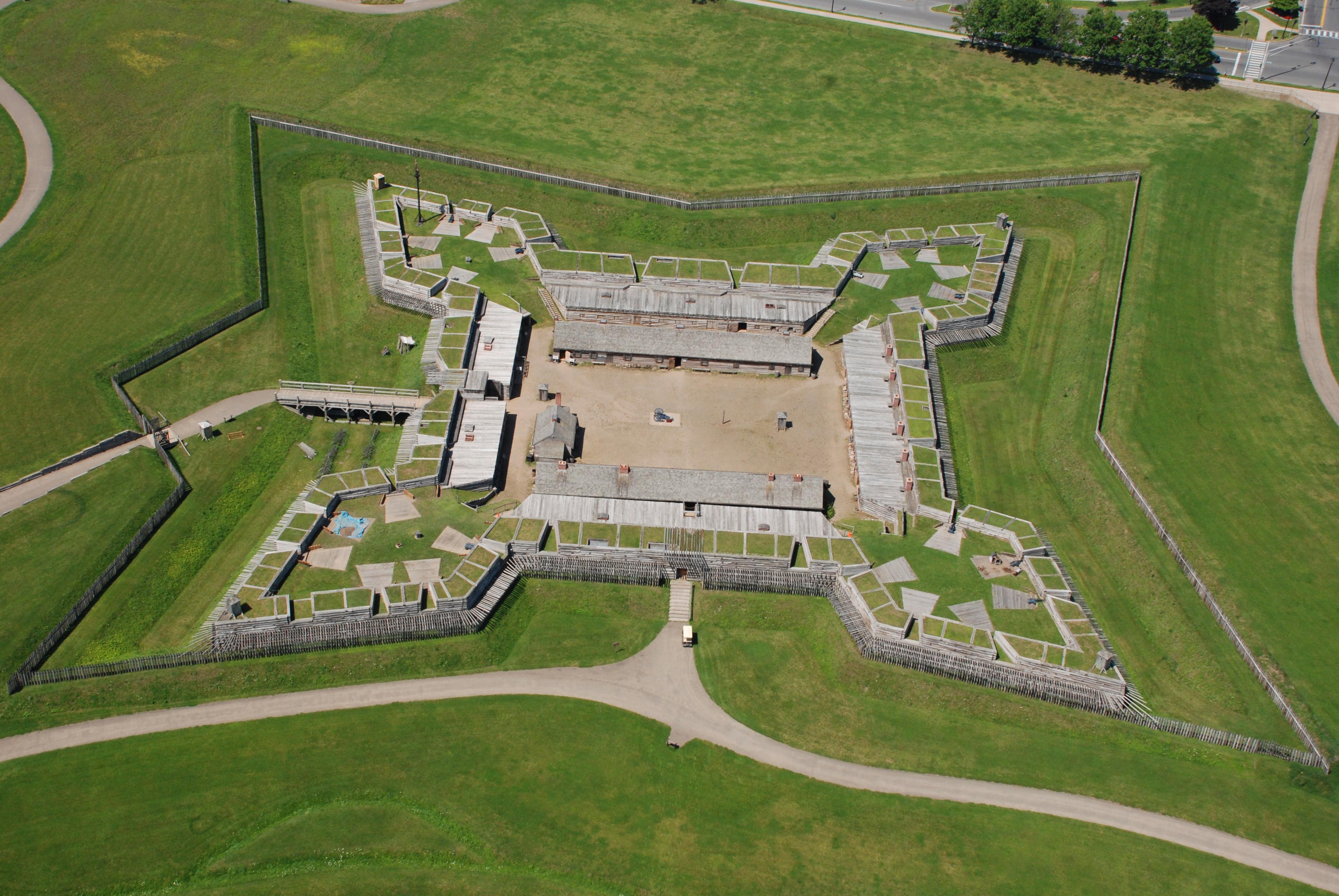
For centuries, the Oneida Carrying Place, a six-mile portage connecting the Mohawk River and Wood Creek, served as a vital link for those traveling by water from the ocean to the Great Lakes. When Eur...

0 mi from route Free near mile 262.5
View on nps.gov
African Burial Ground National Monument

African Burial Ground National Monument

National Monument

The African Burial Ground stands as the oldest and largest known excavated burial site in North America for both free and enslaved Africans. It offers a profound testament to the enduring legacy of Af...

1 mi from route ~2 min detour Free near mile 9.1
View on nps.gov
Federal Hall National Memorial

Federal Hall National Memorial

National Memorial

Here at Federal Hall, George Washington took the oath of office as the first President of the United States, marking the beginning of the American constitutional republic. This historic site served as...

1 mi from route ~3 min detour Free near mile 9.1
View on nps.gov
Stonewall National Monument

Stonewall National Monument

National Monument

Before the 1960s, almost everything about living authentically as a lesbian, a bisexual person or a gay man was illegal. The Stonewall Uprising on June 28, 1969 is a milestone in the quest for civil r...

1 mi from route ~2 min detour Free near mile 9.1
View on nps.gov
Castle Clinton National Monument

Castle Clinton National Monument

National Monument

Located at the southern tip of Manhattan, Castle Clinton marks the place where New York City began and reflects the growth of both the city and the nation. Built to defend the harbor during the War of...

2 mi from route ~4 min detour Free near mile 9.1
View on nps.gov
Governors Island National Monument

Governors Island National Monument

National Monument

From 1794 to 1966, the U.S. Army presence on Governors Island played a vital role in the social, political, and economic life of New York City. The island then served as the headquarters of the U.S. C...

2 mi from route ~6 min detour Free near mile 9.1
View on nps.gov

Park data from the National Park Service API. Alerts update every 2 hours.

Fuel & Cost

Regular Gas

$43.21 one way

$86.42 round trip

$4.18/gal 25.4 MPG avg 92 kg CO2
Fuel Type $/gal One Way Round Trip
midgrade $4.52 $46.72 $93.45
premium $4.92 $50.88 $101.75
diesel $5.61 $57.96 $115.91

Estimated Tolls: $20.25

Holland Tunnel $16.00
New York State Thruway (85.1 mi) $4.25

Toll estimates based on average 2024-2025 rates. EZ-Pass/SunPass discounts may lower the actual cost.

Estimated Trip Cost (one way, 1 person)

Fuel

$43

Tolls

$20

Meals

$25–$50

Total

$88–$113

Rough estimate based on US averages. Hotel $80–$140/night, meals $25–$50/day.

Estimated CO2 emission: 91.8 kg one way. Prices: EIA weekly data, 2026-04-13.

Driving Electric?

About $28 in charging · 0 stops · 66% less CO2

Vehicle Type kWh Stops DC Fast Home Charge
Average EV 78.8 0 $27.56 $12.60
Efficient EV 65.6 0 $22.97 $10.50
EV Truck/SUV 105 1 $36.75 $16.80

Gas CO2

92 kg

EV CO2

31 kg (66% less)

Plan for 0 charging stops, roughly every 270 miles. Allow 25-40 minutes per stop at a DC fast charger.

DC fast charging avg $0.35/kWh. Home charging avg $0.16/kWh. US grid CO2: 0.39 kg/kWh.

Travel Intel

Current conditions at both ends of the drive.

Forecast as of Apr 15, 2026

Origin

East Flatbush, NY

Evening in East Flatbush on Thursday

Local time

5:11 PM

EDT

Current temp

49°F

Unavailable

Live forecast

Destination

Rome, NY

Evening in Rome on Thursday

Local time

5:11 PM

EDT

Current temp

56°F

Unavailable

Live forecast

57°F

Ramapo, NY

131 mi in

Seasonal Notes

Summer travel usually means heavier construction, hotter rest stops, and busier weekend traffic around major cities.

Winter travel shortens daylight, so a route that looks manageable on paper can feel much longer after dark.

Holiday weekends tend to make both departure and arrival windows slower than the raw route time suggests.

Time zone

Same local time

Origin and destination are on the same clock, so arrival timing is easier to judge at a glance.

Temperature spread

7 degrees warmer at arrival

A meaningful temperature swing is a good cue to rethink layers, water, and how soon you want to arrive.

Road read

5h 21m on the road

An early start around 7-8 AM gets you there with plenty of daylight left.

Weather data from the National Weather Service. Conditions may change; check closer to your travel date.

Frequently Asked Questions

The drive from East Flatbush, NY to Rome, NY covers 262.5 miles and takes about 5h 21m without stops. Add 15-30 minutes for a fuel or rest stop on longer drives.
The main roads are NY 17, New York State Thruway, NJ 17. Most of the drive stays on highways, so watch for ramps and exits.
This is a comfortable same-day trip.
The midpoint is about 131.2 miles from East Flatbush, NY. Look for rest areas, gas stations, or food options near the halfway mark.
At current regular gas prices, expect to spend about $43.21 one way. This estimate uses 25.4 MPG — your actual cost will vary with your vehicle's fuel efficiency and current gas prices.
An early start around 7-8 AM gets you there with plenty of daylight left. A late afternoon start means arriving after dark. Morning is better.
Plan about 1 meaningful break for fuel, food, or rest. Plan on a short reset every 3 to 4 hours to stay fresh behind the wheel.
This is a demanding drive. With 31 significant decision points across 262.5 miles, you will need to stay alert - especially through interchange areas and urban stretches. Consider splitting it into segments if you are not comfortable with fast highway navigation.
The main spots that need attention: at 4.9 miles: Highway fork - watch signs carefully. Lane positioning matters here. Multiple destination signs - pick the right one; at 7.2 miles: Highway fork - watch signs carefully. Lane positioning matters here. Multiple destination signs - pick the right one; at 8.6 miles: Exit ramp - move to the correct lane early. Lane positioning matters here. Multiple destination signs - pick the right one.
On the drive from East Flatbush, NY to Rome, NY, road signs begin pointing toward New York State Thruway North: Albany along the way.
Yes. Nearby national parks include Fort Stanwix National Monument, African Burial Ground National Monument and Federal Hall National Memorial. There are 6 parks within detour distance of this route.

Was this helpful?

Thanks for your feedback!

Your tip has been submitted. Thanks!

/500

Explore More

Explore more options from East Flatbush, NY or browse trips ending in Rome, NY.

Looking for more statewide routes? Browse NY road trips.

Explore maps for East Flatbush, NY or Rome, NY on MapSof.net.