Trip from East Norwalk, CT to South Woodstock, CT

Drive Time

2h 30m

Distance

112.5 mi

181 km

Drive Score

8/10

Great drive

Same Day?

Yes, doable

Fuel Cost

$18

one way

EV Charging

Excellent

12 DC fast

Best Time to Leave

Save up to 31 min
4 AM
2h 20m ★
6 AM
2h 30m
8 AM
2h 51m
10 AM
2h 37m
12 PM
2h 35m
3 PM
2h 38m
5 PM
2h 49m
8 PM
2h 24m

Estimated drive times based on typical traffic patterns. Actual times may vary with weather, construction, and real-time conditions.

Downtown East Norwalk, CT, CT

East Norwalk, CT

MART PRODUCTION

village and census-designated place in Woodstock, Windham County, Connecticut, United States

South Woodstock, CT

Wikimedia Commons

Trip Overview

The drive from East Norwalk, CT to South Woodstock, CT covers 112.5 miles and takes about 2h 30m behind the wheel. This route is realistic as a one-day drive if you keep your stops efficient.

The route leans on Wilbur Cross Parkway, I 84, Berlin Turnpike for much of the mileage, and the overall profile is highway-focused drive. The longest uninterrupted segment is about 30.4 miles on Wilbur Cross Parkway. At current regular gas prices, budget about $18.01 one way before food or hotel costs.

Trip Pace

Same-day drive is realistic

A same-day return is realistic if you keep stops short.

Break Rhythm

1 planned break

A short stop every 2 to 3 hours is enough for this drive.

Midpoint

56.2 miles from East Norwalk, CT

A natural place for your longest stop of the day , about 1h 13m into the drive .

Drive Character

This is a 2h 30m highway drive covering 112.5 miles, with most of the trip on Wilbur Cross Parkway and I 84. The longest continuous stretch is about 30.4 miles on Wilbur Cross Parkway.

Most of the miles stay on highways, which makes pacing and fuel planning easier than turn-by-turn city driving.
There are about 21 navigation steps in the underlying route data, so the final approach matters more than the middle miles.
Wilbur Cross Parkway is the longest continuous segment at about 30.4 miles.

How Hard Is This Drive?

This is a straightforward highway drive that stays mostly on Wilbur Cross Parkway and I 84. This route has several spots where lane changes, forks, or exits need your full attention. The trickiest moment comes around 1.8 miles in.

Route Complexity 10/10

High effort - long or complex enough to need steady focus all day

This is a demanding drive. With 14 significant decision points across 112.5 miles, you will need to stay alert — especially through interchange areas and urban stretches. Consider splitting it into segments if you are not comfortable with fast highway navigation.

Where does it get tricky?

The main spots that need attention: at 1.8 miles: Navigation decision point; at 12.7 miles: Exit ramp - move to the correct lane early. Lane positioning matters here. Multiple destination signs - pick the right one; at 16.6 miles (CT 8): Highway fork - watch signs carefully. Multiple destination signs - pick the right one.

Critical Maneuvers

5 of 14 key points

These are the spots where you need to pay the most attention. Preview them before you drive.

5
1.8 mi into trip | ~3m in

Take the ramp toward I 95 North: New Haven

Navigation decision point

Toward I 95 North: New Haven
8
12.7 mi into trip | ~18m in

Take the exit toward CT 25, CT 8: Trumbull, Waterbury

Exit ramp - move to the correct lane early. Lane positioning matters here. Multiple destination signs - pick the right one

Use the right lane. Exit 27A Toward CT 25, CT 8: Trumbull, Waterbury
6
16.6 mi into trip | ~23m in | CT 8

Keep slight right at fork onto CT 8 toward CT 8 North: Waterbury, New Haven

Highway fork - watch signs carefully. Multiple destination signs - pick the right one

Toward CT 8 North: Waterbury, New Haven
8
18.4 mi into trip | ~25m in

Take the exit toward CT 15 North: Merritt Parkway, New Haven

Exit ramp - move to the correct lane early. Lane positioning matters here. Multiple destination signs - pick the right one

Use the slight right lane. Exit 6 Toward CT 15 North: Merritt Parkway, New Haven
7
69.6 mi into trip | ~1h 30m in | I 84; US 6

Keep slight left at fork onto I 84; US 6 toward I 84 East: Boston

Highway fork - watch signs carefully. Lane positioning matters here

Use the straight / slight right lanes. Toward I 84 East: Boston

Towns Along This Route

Between East Norwalk, CT and South Woodstock, CT, road signs point toward Waterbury and New Haven.

Waterbury

12.7 mi in | ~18m

New Haven

16.6 mi in | ~23m | via CT 8

Main Roads

Road Distance Duration
Wilbur Cross Parkway 30.4 mi 37m
I 84 28.3 mi 32m
Berlin Turnpike 15.7 mi 20m
I 95 10.7 mi 14m
Old Turnpike Road 6.3 mi 11m
CT 8 5 mi 5m
Route 169 4.4 mi 7m
Merritt Parkway 3 mi 4m
Longest stretch: Wilbur Cross Parkway — 30.4 mi, about 37m

Turn-by-Turn Driving Directions

Step-by-step road directions between East Norwalk, CT and South Woodstock, CT.

1

Start on CT 136

0.8 mi · 1 min · Winfield Street
2

Continue on CT 136

1.0 mi · 1 min · Saugatuck Avenue
3

Take the ramp

0.3 mi · 34 sec
Toward I 95 North: New Haven
4

Merge onto I 95

11 mi · 14 min · I 95
Use the straight / slight right lanes.
5

Take the exit

0.6 mi · 1 min
Exit 27A Toward CT 25, CT 8: Trumbull, Waterbury Use the right lane.
6

Continue on CT 8; CT 25

3.2 mi · 3 min · CT 8; CT 25
Use the straight / right lanes.
7

Keep slight right at fork onto CT 8

1.8 mi · 2 min · CT 8
Toward CT 8 North: Waterbury, New Haven
8

Take the exit

0.7 mi · 1 min
Exit 6 Toward CT 15 North: Merritt Parkway, New Haven Use the slight right lane.
9

Merge onto CT 15

3.0 mi · 4 min · Merritt Parkway
Use the straight / slight right lanes.
10

Continue on CT 15

30 mi · 37 min · Wilbur Cross Parkway
Use the straight / slight right lanes.
11

Continue on US 5; CT 15

16 mi · 20 min · Berlin Turnpike
Use the straight / right lanes.
12

Merge onto I 84; US 6

1.4 mi · 1 min · I 84; US 6
13

Keep slight left at fork onto I 84; US 6

27 mi · 30 min · I 84; US 6
Toward I 84 East: Boston Use the straight / slight right lanes.
14

Take the exit

0.2 mi · 27 sec
Exit 73 Toward CT 190: Union
15

Turn right onto CT 190

1.9 mi · 3 min · Buckley Highway
16

Turn right onto CT 171

2.3 mi · 4 min · Bigelow Hollow Road
17

Keep slight left at fork onto CT 197

0.9 mi · 1 min · Lawson Road
18

Continue on CT 197

6.3 mi · 11 min · Old Turnpike Road
19

Turn right onto CT 169

4.4 mi · 7 min · Route 169
20

Turn left onto Stone Bridge Road

271 ft · 11 sec · Stone Bridge Road
21

Arrive at destination

Stone Bridge Road

Trip Plan

Morning Departure

Leave by 9 AM and you'll arrive before lunch.

Evening Departure

Even a 4 PM departure gets you there before dark in summer.

You can normally do this drive in one day.
Plan roughly 1 meaningful break for fuel, food, and rest.
The halfway point lands around 56.2 miles from East Norwalk, CT, or about 1h 13m into the drive.
The longest continuous stretch on this route runs about 30.4 miles.

This is a comfortable same-day trip.

Departure

Before you leave

Start with fuel, water, and navigation already sorted so the first hour feels easy.

First stop

Around 80 miles or 1h 42m in

Use this first pause for coffee, a restroom break, and a quick traffic check ahead.

Halfway reset

Around 56.2 miles or 1h 13m in

This is the best place for your longest stop, a real meal, and a full fuel check.

Final approach

Final hour starts around 1h 56m

Traffic, exits, and arrival timing usually matter more near South Woodstock, CT than in the middle of the route.

Before You Leave

+

Open the route before leaving East Norwalk, CT so your first major turns are already loaded.

+

Leave with enough water and a charging cable within reach, not packed away.

+

Check your fuel range against the first long segment, especially if you are starting outside city service areas.

Day 1

Settle into the route from East Norwalk, CT

This is one driving day of about 112.5 miles and 2h 30m.

Your first comfortable stop window is around 80 miles from East Norwalk, CT.
This route can stay practical as a one-day drive if traffic stays reasonable.
Plan about 1 real break rather than only quick fuel stops.
The longest stretch is on Wilbur Cross Parkway for about 30.4 miles.

Where to Stop

Rest stops, refuel points, and overnight suggestions along this route.

Halfway Point

Midpoint

About 56.2 mi from East Norwalk, CT · 1h 13m into the drive

Downtown Smithtown, NY, NY

Mid-route town

Meal stop

Smithtown, NY

56 mi into the route

Best for: Lunch, fuel, and a longer reset

This sits close to the middle of the route, so it works well for the longest stop of the day.

Pacing Suggestions

Smithtown, NY

Fuel and coffee

A short stop after about 80 miles helps settle the day before fatigue starts building.

Smithtown, NY

Meal break

The midpoint is around 56.2 miles from East Norwalk, CT, which is a good place for a longer meal and fuel stop.

Arriving in South Woodstock, CT

The final approach into South Woodstock, CT usually feels slower than the middle of the drive, so avoid planning your tightest schedule at the very end.

Try to arrive with enough fuel left to skip an immediate station stop unless you already know the area around South Woodstock, CT.

These stop ideas are pacing suggestions — the exact town or exit can change with traffic, hotel plans, and fuel range.

National Parks Near This Route

Worth a detour if your schedule allows.

Weir Farm National Historical Park

Weir Farm National Historical Park

National Historical Park

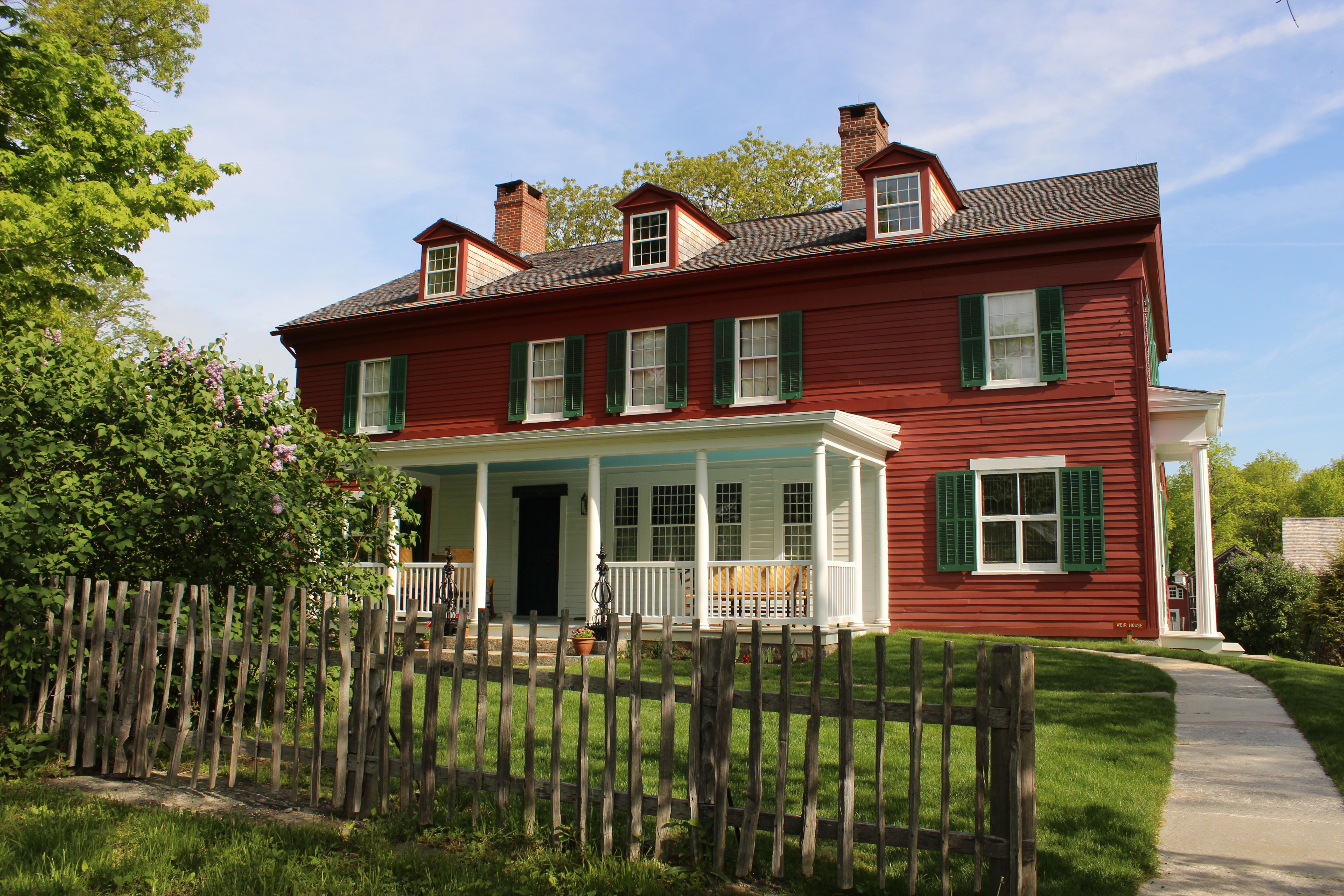
Visit the home and studio of America's most beloved Impressionist, J. Alden Weir, and walk in the footsteps of generations of world-class artists. Set amidst more than 60 acres of painterly woods, fie...

11 mi from route ~27 min detour Free
View on nps.gov
New England National Scenic Trail

New England National Scenic Trail

National Scenic Trail

From the Sound to the summits: the New England Trail covers 235 miles from Long Island Sound across long ridges to scenic mountain summits in Connecticut and Massachusetts. The trail offers panoramic...

28 mi from route ~70 min detour Free near mile 96.9
View on nps.gov

Park data from the National Park Service API. Alerts update every 2 hours.

Fuel & Cost

Regular Gas

$18.01 one way

$36.02 round trip

$4.07/gal 25.4 MPG avg 39 kg CO2
Fuel Type $/gal One Way Round Trip
midgrade $4.46 $19.74 $39.48
premium $4.83 $21.38 $42.77
diesel $5.64 $24.99 $49.99

Estimated Tolls: $1.54

Berlin Turnpike (15.7 mi) $1.10
Old Turnpike Road (6.3 mi) $0.44

Toll estimates based on average 2024-2025 rates. EZ-Pass/SunPass discounts may lower the actual cost.

Estimated Trip Cost (one way, 1 person)

Fuel

$18

Tolls

$2

Meals

$25–$50

Total

$45–$70

Rough estimate based on US averages. Hotel $80–$140/night, meals $25–$50/day.

Estimated CO2 emission: 39.4 kg one way. Prices: EIA weekly data, 2026-04-06.

EV Charging Along Route

12 DC fast chargers · Coverage: excellent

Bridgeport - Tesla Supercharger

Bridgeport, CT

Tesla

16 DCFC

Wegmans - Tesla Supercharger

Norwalk, CT

Tesla

12 DCFC

Fairfield NB - Tesla Supercharger

Fairfield, CT

Tesla

12 DCFC

Fairfield Centre Shopping Center - Tesla Supercharger

Fairfield, CT

Tesla

12 DCFC

Connecticut Welcome Center - Tesla Supercharger

Darien, CT

Tesla

10 DCFC

Fairfield SB - Tesla Supercharger

Fairfield, CT

Tesla

8 DCFC

I-95 Darien NB Service Plaza

Darien, CT

APPLEGREEN

4 DCFC

MARITIME CHEVROLET

FAIRFIELD, CT

EV Connect

3 DCFC

Tesla: 6 APPLEGREEN: 4 EV Connect: 2

Station data from NREL Alternative Fuel Stations database.

Driving Electric?

About $12 in charging · 0 stops · 67% less CO2

Vehicle Type kWh Stops DC Fast Home Charge
Average EV 33.8 0 $11.81 $5.40
Efficient EV 28.1 0 $9.84 $4.50
EV Truck/SUV 45 0 $15.75 $7.20

Gas CO2

39 kg

EV CO2

13 kg (67% less)

This trip is well within single-charge range for most EVs. No charging stops needed if you start fully charged.

DC fast charging avg $0.35/kWh. Home charging avg $0.16/kWh. US grid CO2: 0.39 kg/kWh.

Travel Intel

Current conditions at both ends of the drive.

Forecast data refreshed 3 days ago

Origin

East Norwalk, CT

Afternoon in East Norwalk on Monday

Local time

2:06 PM

EDT

Current temp

53°F

Unavailable

Live forecast

Destination

South Woodstock, CT

Afternoon in South Woodstock on Monday

Local time

2:06 PM

EDT

Current temp

52°F

Unavailable

Live forecast

Seasonal Notes

Summer travel usually means heavier construction, hotter rest stops, and busier weekend traffic around major cities.

Winter travel shortens daylight, so a route that looks manageable on paper can feel much longer after dark.

Holiday weekends tend to make both departure and arrival windows slower than the raw route time suggests.

Time zone

Same local time

Origin and destination are on the same clock, so arrival timing is easier to judge at a glance.

Temperature spread

1 degrees cooler at arrival

A meaningful temperature swing is a good cue to rethink layers, water, and how soon you want to arrive.

Road read

2h 30m on the road

Use the two city cards together: check the sky where you start, then compare it with the local time and temperature at arrival.

Weather data from the National Weather Service. Conditions may change; check closer to your travel date.

Frequently Asked Questions

The drive from East Norwalk, CT to South Woodstock, CT covers 112.5 miles and takes about 2h 30m without stops. Add 15-30 minutes for a fuel or rest stop on longer drives.
The main roads are Wilbur Cross Parkway, I 84, Berlin Turnpike. Most of the drive stays on highways, so watch for ramps and exits.
This is a comfortable same-day trip.
The midpoint is about 56.2 miles from East Norwalk, CT. Look for rest areas, gas stations, or food options near the halfway mark.
At current regular gas prices, expect to spend about $18.01 one way. This estimate uses 25.4 MPG — your actual cost will vary with your vehicle's fuel efficiency and current gas prices.
Leave by 9 AM and you'll arrive before lunch. Even a 4 PM departure gets you there before dark in summer.
Plan about 1 meaningful break for fuel, food, or rest. A short stop every 2 to 3 hours is enough for this drive.
This is a demanding drive. With 14 significant decision points across 112.5 miles, you will need to stay alert — especially through interchange areas and urban stretches. Consider splitting it into segments if you are not comfortable with fast highway navigation.
The main spots that need attention: at 1.8 miles: Navigation decision point; at 12.7 miles: Exit ramp - move to the correct lane early. Lane positioning matters here. Multiple destination signs - pick the right one; at 16.6 miles (CT 8): Highway fork - watch signs carefully. Multiple destination signs - pick the right one.
Between East Norwalk, CT and South Woodstock, CT, road signs point toward Waterbury and New Haven.

Was this route helpful?

Thanks for your feedback!

Your tip has been submitted. Thanks!

/500

Explore More

Return Trip

South Woodstock, CT to East Norwalk, CT

Plan the drive back the other way.

112.4 mi 2h 30m

Explore more options from East Norwalk, CT or browse trips ending in South Woodstock, CT.

Looking for more statewide routes? Browse CT road trips.

Explore maps for East Norwalk, CT or South Woodstock, CT on MapSof.net.