Trip from El Paso, TX to La Homa, TX

Drive Time

13h 25m

Distance

739.9 mi

1,191 km

Drive Score

7/10

Good drive

Same Day?

2-day trip

Fuel Cost

$113

one way

EV Charging

Excellent

24 DC fast

Best Time to Leave

Save up to 36 min
4 AM
13h 14m ★
6 AM
13h 26m
8 AM
13h 50m
10 AM
13h 34m
12 PM
13h 32m
3 PM
13h 35m
5 PM
13h 49m
8 PM
13h 18m

Estimated drive times based on typical traffic patterns. Actual times may vary with weather, construction, and real-time conditions.

Downtown El Paso, TX, TX

El Paso, TX

Wikimedia Commons

Downtown La Homa, TX, TX

La Homa, TX

Jeff Stapleton

Trip Overview

The drive from El Paso, TX to La Homa, TX covers 739.9 miles and takes about 13h 25m behind the wheel. It usually feels better as a 2-day road trip than as one long push.

The route leans on I 10, US Highway 90 East, Sanderson Highway for much of the mileage, and the overall profile is long-distance drive. The longest uninterrupted segment is about 237.1 miles on I 10. At current regular gas prices, budget about $113.02 one way before food or hotel costs.

Trip Pace

Best split across 2 days

Treat the return leg as its own travel day rather than an afterthought.

Break Rhythm

3 planned breaks

Plan on a short reset every 3 to 4 hours to stay fresh behind the wheel.

Midpoint

370 miles from El Paso, TX

A natural place for your longest stop of the day , about 6h 21m into the drive .

Drive Character

At 739.9 miles and 13h 25m of driving, this is a route where fuel stops, weather, and timing matter more than any single turn. The main roads are I 10 and US Highway 90 East.

Most of the miles stay on highways, which makes pacing and fuel planning easier than turn-by-turn city driving.
There are about 42 navigation steps in the underlying route data, so the final approach matters more than the middle miles.
I 10 is the longest continuous segment at about 237.1 miles.

How Hard Is This Drive?

This is a straightforward highway drive that stays mostly on I 10 and US Highway 90 East. This route has several spots where lane changes, forks, or exits need your full attention. The trickiest moment comes around 0.2 miles in near East Franklin Avenue.

Route Complexity 7/10

Demanding - plan breaks and stay ahead of the key maneuvers

This is a demanding drive. With 22 significant decision points across 739.9 miles, you will need to stay alert — especially through interchange areas and urban stretches. Consider splitting it into segments if you are not comfortable with fast highway navigation.

Where does it get tricky?

The main spots that need attention: at 0.2 miles (East Franklin Avenue): Navigation decision point; at 0.8 miles (I 10; US 180): Merge point - match speed before joining. Lane positioning matters here; at 237.9 miles: Exit ramp - move to the correct lane early. Multiple destination signs - pick the right one.

Critical Maneuvers

5 of 22 key points

These are the spots where you need to pay the most attention. Preview them before you drive.

5
0.2 mi into trip | ~0m in | East Franklin Avenue

Turn right onto East Franklin Avenue

Navigation decision point

5
0.8 mi into trip | ~1m in | I 10; US 180

Merge onto I 10; US 180

Merge point - match speed before joining. Lane positioning matters here

Use the straight / slight right lanes.
6
237.9 mi into trip | ~3h 51m in

Take the exit toward US 285: Pecos, Sanderson

Exit ramp - move to the correct lane early. Multiple destination signs - pick the right one

Exit 257 Toward US 285: Pecos, Sanderson
6
727.4 mi into trip | ~13h 8m in | US 83 / La Joya Bypass

Keep slight left at fork onto US 83 / La Joya Bypass

Highway fork - watch signs carefully. Lane positioning matters here

Use the straight / slight right lanes.
8
737.5 mi into trip | ~13h 19m in

Take the exit toward Texas 364: Bentsen Palm Drive, La Homa Road

Exit ramp - move to the correct lane early. Lane positioning matters here. Multiple destination signs - pick the right one

Use the straight / slight right lanes. Exit 133 Toward Texas 364: Bentsen Palm Drive, La Homa R...

Towns Along This Route

On the drive from El Paso, TX to La Homa, TX, road signs begin pointing toward Sanderson along the way.

Sanderson

237.9 mi in | ~3h 51m

Main Roads

Road Distance Duration
I 10 237.1 mi 3h 49m
US Highway 90 East 113.2 mi 2h 8m
Sanderson Highway 63.5 mi 1h 12m
South US Highway 83 62 mi 1h 4m
United States Highway 83 62 mi 1h 9m
US 277 47.5 mi 54m
East Main Street 43.8 mi 50m
Purple Heart Trail 17.6 mi 18m
Longest stretch: I 10 — 237.1 mi, about 3h 49m

Turn-by-Turn Driving Directions

Step-by-step road directions between El Paso, TX and La Homa, TX.

1

Start on North Mesa Street

0.2 mi · 24 sec · North Mesa Street
2

Turn right onto East Franklin Avenue

0.2 mi · 26 sec · East Franklin Avenue
3

Take the ramp

0.4 mi · 50 sec
Toward I 10 East
4

Merge onto I 10; US 180

167 mi · 2 hr 43 min · I 10; US 180
Use the straight / slight right lanes.
5

Keep slight right at fork onto I 10

70 mi · 1 hr 5 min · I 10
6

Take the exit

0.3 mi · 33 sec
Exit 257 Toward US 285: Pecos, Sanderson
7

Continue on Interstate 10 West

0.1 mi · 21 sec · Interstate 10 West
8

Take the ramp

156 ft · 4 sec
9

Merge onto US 285

2.1 mi · 2 min · North US Highway 285
10

Turn right onto US 285

0.3 mi · 29 sec · North Alamo Street
11

Continue on US 285

63 mi · 1 hr 12 min · Sanderson Highway
12

At end of road, turn left onto US 90

2.1 mi · 2 min · West Oak Street
13

Continue on US 90

113 mi · 2 hr 8 min · US Highway 90 East
14

Take the exit onto Loop 79

12 mi · 13 min · Loop 79
15

At end of road, turn left onto US 277

48 mi · 54 min · US 277
16

Turn left onto US 277

2.8 mi · 4 min · North Veterans Boulevard
17

Turn left onto US 57; US 277

42 mi · 48 min · East Main Street
18

Turn right onto Loop 225

0.2 mi · 14 sec · South 5th Street
19

Turn slight left onto Loop 225

0.3 mi · 22 sec · Loop 225
20

At end of road, turn right onto US 83

62 mi · 1 hr 4 min · South US Highway 83
21

Continue on US 83

0.3 mi · 26 sec · I-35 Frontage Road
22

Take the ramp onto US 83

0.1 mi · 18 sec · US 83
23

Merge onto I 35; I 27; US 83

18 mi · 18 min · Purple Heart Trail
24

Continue on US 83

0.1 mi · 16 sec · Santa Ursula Avenue
25

Turn left onto US 83

0.4 mi · 53 sec · Matamoros Street
26

Continue on US 83

1.0 mi · 2 min · Chihuahua Street
27

Turn right onto North Meadow Avenue

2.0 mi · 4 min · North Meadow Avenue
28

Turn right onto US 83

5.4 mi · 7 min · South Zapata Highway
29

Continue on US 83

14 mi · 15 min · US Highway 83 South
30

Continue on US 83

54 mi · 1 hr 1 min · United States Highway 83
31

Continue on US 83

17 mi · 20 min · North Grant Street
32

Continue on US 83

7.7 mi · 8 min · United States Highway 83
33

Continue on US 83

0.4 mi · 32 sec · West Main Street
34

Continue on US 83

1.9 mi · 2 min · East Main Street
35

Continue on US 83

15 mi · 17 min · East US Highway 83
36

Continue on US 83

3.1 mi · 3 min · West Expressway 83
37

Keep slight left at fork onto US 83

10 mi · 11 min · La Joya Bypass
Use the straight / slight right lanes.
38

Take the exit

0.2 mi · 26 sec
Exit 133 Toward Texas 364: Bentsen Palm Drive, La Homa Road Use the straight / slight right lanes.
39

Turn straight onto Expressway 83

0.8 mi · 1 min · Expressway 83
40

Turn left onto South Bentsen Palm Drive

1.2 mi · 2 min · South Bentsen Palm Drive
41

Turn right onto Del Norte Drive

0.2 mi · 52 sec · Del Norte Drive
42

Arrive at destination

Del Norte Drive

Trip Plan

Morning Departure

Start early — leave by 6-7 AM to arrive at a reasonable hour.

Evening Departure

This is a long drive — plan for a morning departure or consider splitting it into two days.

This drive is better paced as a 2-day trip.
Plan roughly 3 meaningful breaks for fuel, food, and rest.
The halfway point lands around 370 miles from El Paso, TX, or about 6h 21m into the drive.
The longest continuous stretch on this route runs about 237.1 miles.

Consider an overnight stop or starting very early.

Departure

Before you leave

Start with fuel, water, and navigation already sorted so the first hour feels easy.

First stop

Around 163 miles or 2h 40m in

Use this first pause for coffee, a restroom break, and a quick traffic check ahead.

Halfway reset

Around 370 miles or 6h 21m in

This is the best place for your longest stop, a real meal, and a full fuel check.

Overnight split

Day 1 wrap after about 370 miles or 6h 21m

Stop before fatigue turns the last few hours into a grind. You want day two to start fresh, not just resumed.

Final approach

Final hour starts around 12h 13m

Traffic, exits, and arrival timing usually matter more near La Homa, TX than in the middle of the route.

Before You Leave

+

Open the route before leaving El Paso, TX so your first major turns are already loaded.

+

Leave with enough water and a charging cable within reach, not packed away.

+

Check your fuel range against the first long segment, especially if you are starting outside city service areas.

+

Pick one backup stop option before the midpoint in case traffic changes your pacing.

+

Treat this as a 2-day road trip and book the overnight stop before the busiest arrival window.

Day 1

Settle into the route from El Paso, TX

Aim for roughly 370 miles and 6.7 hours of wheel time on this day.

Day 2

Finish the approach into La Homa, TX

Aim for roughly 370 miles and 6.7 hours of wheel time on this day.

Your first comfortable stop window is around 163 miles from El Paso, TX.
This route usually feels better as a 2-day drive than as one long push.
Plan about 3 real breaks rather than only quick fuel stops.
The longest stretch is on I 10 for about 237.1 miles.

Where to Stop

Rest stops, refuel points, and overnight suggestions along this route.

Halfway Point

Midpoint

About 370 mi from El Paso, TX · 6h 21m into the drive

Downtown McCamey, TX, TX

First major stop

Coffee and fuel

McCamey, TX

244 mi into the route

Best for: Coffee, fuel, and an easy first stretch

This is a natural early stop once the first hours of the drive are behind you.

Downtown Laredo, TX, TX

Second major stop

Overnight candidate

Laredo, TX

488 mi into the route

Best for: Hotel check-in, dinner, and a fresh start

This lines up well with a realistic day-end stop if you are breaking the drive into stages.

Find hotels in Laredo, TX

Overnight Options

Night 1

Eagle Pass, TX

370 mi · about 6.7h in

A practical overnight split lands near Eagle Pass, TX after about 370 miles or 6.7 hours of driving.

Find hotels

Pacing Suggestions

Fort Davis, TX

Fuel and coffee

A short stop after about 163 miles helps settle the day before fatigue starts building.

Eagle Pass, TX

Meal break

The midpoint is around 370 miles from El Paso, TX, which is a good place for a longer meal and fuel stop.

Before the longest stretch

Fuel check

Top up before I 10 if your tank is already low. That segment runs about 237.1 miles.

Overnight split

Hotel stop

For a steadier pace, wrap day one after about 370 miles or 6.7 hours on the road.

Arriving in La Homa, TX

The final approach into La Homa, TX usually feels slower than the middle of the drive, so avoid planning your tightest schedule at the very end.

Try to arrive with enough fuel left to skip an immediate station stop unless you already know the area around La Homa, TX.

On a multi-day trip, keep the last day a little lighter so you reach La Homa, TX with some flexibility left in the schedule.

After long uninterrupted mileage, take five minutes before the last urban segment to reset and refocus on exits, merges, and city traffic.

These stop ideas are pacing suggestions — the exact town or exit can change with traffic, hotel plans, and fuel range.

National Parks Near This Route

Worth a detour if your schedule allows.

Amistad National Recreation Area

Amistad National Recreation Area

National Recreation Area

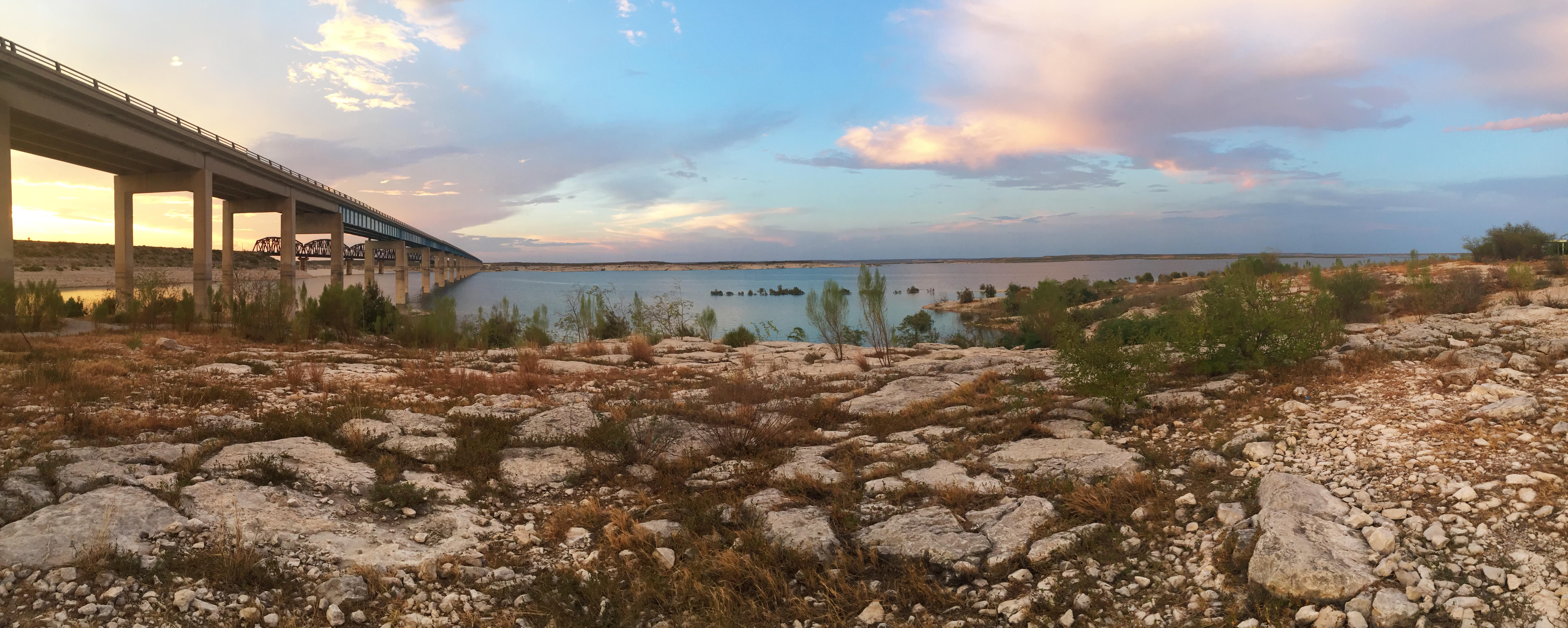
An oasis in the desert, Amistad National Recreation Area consists of the US portion of the International Amistad Reservoir. Amistad, a Spanish word meaning "friendship," is known for excellent water-b...

2 mi from route ~4 min detour Free near mile 408.2
Park Closure: Diablo East Marina Cove, Scuba Cove, and Walkway Access Are Closed
Caution: Help Prevent Aquatic Invasive Species (AIS) Infestation
View on nps.gov
Chamizal National Memorial

Chamizal National Memorial

National Memorial

Chamizal is more than just an urban park to recreate or enjoy a quiet afternoon. These grounds are a reminder of the harmonious settlement of a 100-year boundary dispute between the United States and...

2 mi from route ~5 min detour Free
View on nps.gov

Park data from the National Park Service API. Alerts update every 2 hours.

Fuel & Cost

Regular Gas

$113.02 one way

$226.05 round trip

$3.88/gal 25.4 MPG avg 259 kg CO2
Fuel Type $/gal One Way Round Trip
midgrade $4.25 $123.86 $247.72
premium $4.59 $133.74 $267.47
diesel $5.64 $164.38 $328.76

No toll roads detected on this route.

Estimated Trip Cost (one way, 1 person)

Fuel

$113

Hotel (1n)

$80–$140

Meals

$50–$100

Total

$243–$353

Rough estimate based on US averages. Hotel $80–$140/night, meals $25–$50/day.

Estimated CO2 emission: 258.9 kg one way. Prices: EIA weekly data, 2026-04-06.

EV Charging Along Route

24 DC fast chargers · Coverage: excellent

Rudy's Country Store & BBQ - Tesla Supercharger

El Paso, TX

Tesla

12 DCFC

TA, Horizon Blvd, El Paso, TX

El Paso, TX

BP_PULSE

12 DCFC

Porter's - Tesla Supercharger

Van Horn, TX

Tesla

12 DCFC

Starbucks - Tesla Supercharger

El Paso, TX

Tesla

8 DCFC

Flying J Travel Center - Tesla Supercharger

Fort Stockton, TX

Tesla

8 DCFC

Rudy's Country Store & BBQ - Tesla Supercharger

Del Rio, TX

Tesla

8 DCFC

Embassy Suites by Hilton - Tesla Supercharger

Laredo, TX

Tesla

8 DCFC

Walmart 512 (El Paso, TX)

El Paso, TX

Electrify America

4 DCFC

ChargePoint Network: 8 Tesla: 6 EV Connect: 3 Electrify America: 3 BP_PULSE: 1 SWTCH: 1 eVgo Network: 1 FORD_CHARGE: 1

Station data from NREL Alternative Fuel Stations database.

Driving Electric?

About $78 in charging · 2 stops · 66% less CO2

Vehicle Type kWh Stops DC Fast Home Charge
Average EV 222 2 $77.69 $35.52
Efficient EV 185 2 $64.74 $29.60
EV Truck/SUV 296 3 $103.59 $47.35

Gas CO2

259 kg

EV CO2

87 kg (66% less)

Plan for 2 charging stops, roughly every 270 miles. Allow 25-40 minutes per stop at a DC fast charger.

DC fast charging avg $0.35/kWh. Home charging avg $0.16/kWh. US grid CO2: 0.39 kg/kWh.

Travel Intel

Current conditions at both ends of the drive.

Forecast data refreshed 3 days ago

Origin

El Paso, TX

Morning in El Paso on Monday

Local time

11:52 AM

MDT

Current temp

55°F

Unavailable

Live forecast

Destination

La Homa, TX

Afternoon in La Homa on Monday

Local time

12:52 PM

CDT

Current temp

82°F

Unavailable

Live forecast

Seasonal Notes

Summer travel usually means heavier construction, hotter rest stops, and busier weekend traffic around major cities.

Winter travel shortens daylight, so a route that looks manageable on paper can feel much longer after dark.

Holiday weekends tend to make both departure and arrival windows slower than the raw route time suggests.

For long drives, weather on day two can matter just as much as conditions at departure, so check the whole travel window rather than only the first day.

Time zone

1 hour later

The destination clock does not match departure time, so double-check hotel check-in windows and late arrival plans.

Temperature spread

27 degrees warmer at arrival

A meaningful temperature swing is a good cue to rethink layers, water, and how soon you want to arrive.

Road read

13h 25m on the road

This is long enough that the arrival forecast matters almost as much as departure conditions. Recheck both ends before you roll.

Weather data from the National Weather Service. Conditions may change; check closer to your travel date.

Frequently Asked Questions

The drive from El Paso, TX to La Homa, TX covers 739.9 miles and takes about 13h 25m without stops. Add 15-30 minutes for a fuel or rest stop on longer drives.
The main roads are I 10, US Highway 90 East, Sanderson Highway. Expect a mix of highway and local road driving.
Consider an overnight stop or starting very early.
Yes. This route is usually more comfortable as a 2-day drive. A sensible stopping point is after roughly 370 miles on day one.
The midpoint is about 370 miles from El Paso, TX. Look for rest areas, gas stations, or food options near the halfway mark.
At current regular gas prices, expect to spend about $113.02 one way. This estimate uses 25.4 MPG — your actual cost will vary with your vehicle's fuel efficiency and current gas prices.
Start early — leave by 6-7 AM to arrive at a reasonable hour. This is a long drive — plan for a morning departure or consider splitting it into two days.
Plan about 3 meaningful breaks for fuel, food, or rest. Plan on a short reset every 3 to 4 hours to stay fresh behind the wheel.
This is a demanding drive. With 22 significant decision points across 739.9 miles, you will need to stay alert — especially through interchange areas and urban stretches. Consider splitting it into segments if you are not comfortable with fast highway navigation.
The main spots that need attention: at 0.2 miles (East Franklin Avenue): Navigation decision point; at 0.8 miles (I 10; US 180): Merge point - match speed before joining. Lane positioning matters here; at 237.9 miles: Exit ramp - move to the correct lane early. Multiple destination signs - pick the right one.
On the drive from El Paso, TX to La Homa, TX, road signs begin pointing toward Sanderson along the way.

Was this route helpful?

Thanks for your feedback!

Your tip has been submitted. Thanks!

/500

Explore More

Return Trip

La Homa, TX to El Paso, TX

Plan the drive back the other way.

802.9 mi 11h 54m

Explore more options from El Paso, TX or browse trips ending in La Homa, TX.

Looking for more statewide routes? Browse TX road trips.

Explore maps for El Paso, TX or La Homa, TX on MapSof.net.