The drive from Gainesville, GA to Georgetown, GA covers 268.4 miles and takes about 5h 30m behind the wheel.
This route is realistic as a one-day drive if you keep your stops efficient.
The route leans on US 25, Jim Gillis Historic Savannah Parkway, Carl Sanders Highway for much of the mileage,
and the overall profile is turn-heavy local drive.
The longest uninterrupted segment is about 44.6 miles on US 25.
At current regular gas prices, budget about $41.97 one way before food or hotel costs.
Trip Pace
Same-day drive is realistic
A same-day return is possible, but it will make for a full day on the road.
Break Rhythm
1 planned break
Plan on a short reset every 3 to 4 hours to stay fresh behind the wheel.
Midpoint
134.2 miles from Gainesville, GA
A natural place for your longest stop of the day
, about 2h 47m into the drive
.
Who Is This Route For?
Weekend Trip
Doable as a same-day drive at 5h 30m. Total distance: 268.4 miles.
Family Friendly
Moderate complexity with 1 natural rest stops along the way.
Solo Traveler
5h 30m drive, comfortable solo distance.
Scenic Drive
Turn-heavy local drive route profile with national parks nearby.
Drive Character
Expect a 5h 30m drive with frequent turns across 268.4 miles of local and secondary roads.
This route has more turning and local-road decision points than a simple highway run.
There are about 53 navigation steps in the underlying route data, so the final approach matters more than the middle miles.
US 25 is the longest continuous segment at about 44.6 miles.
How Hard Is This Drive?
Expect a hands-on drive with frequent turns and local roads rather than long highway stretches. This route has several spots where lane changes, forks, or exits need your full attention. The trickiest moment comes around 40.2 miles in near US 129; US 441; 10 Loop; 15 / Inner Loop 10.
Driving Effort10/10
High effort - long or complex enough to need steady focus all day
Balances navigation complexity with total wheel time.
This is a demanding drive. With 32 significant decision points across 268.4 miles, you will need to stay alert - especially through interchange areas and urban stretches. Consider splitting it into segments if you are not comfortable with fast highway navigation.
Where does it get tricky?
The main spots that need attention: at 40.2 miles (US 129; US 441; 10 Loop; 15 / Inner Loop 10): Exit ramp - move to the correct lane early. Lane positioning matters here. Multiple destination signs - pick the right one; at 42.7 miles: Exit ramp - move to the correct lane early. Lane positioning matters here. Multiple destination signs - pick the right one; at 107 miles: Lane positioning matters here.
Critical Maneuvers
5 of 32 key points
These are the spots where you need to pay the most attention. Preview them before you drive.
8
40.2 mi into trip|~55m in|US 129; US 441; 10 Loop; 15 / Inner Loop 10
Take the exit onto US 129; US 441; 10 Loop; 15 / Inner Loop 10 toward US 129 South, US 441 South, GA 10 Loop Inner: Watkinsville, Lexington
Exit ramp - move to the correct lane early. Lane positioning matters here. Multiple destination signs - pick the right one
Use the slight right lane.
Exit 10C
Toward US 129 South, US 441 South, GA 10 Loop I...
8
42.7 mi into trip|~58m in
Take the exit toward US 78, GA 10: Oconee Street, Lexington Road
Exit ramp - move to the correct lane early. Lane positioning matters here. Multiple destination signs - pick the right one
Use the right lane.
Exit 8
Toward US 78, GA 10: Oconee Street, Lexington R...
7
107 mi into trip|~2h 17m in
Take the ramp toward I-20 East: Augusta
Lane positioning matters here
Use the left lane.
Toward I-20 East: Augusta
7
130.9 mi into trip|~2h 43m in
Take the exit toward I 520 East, GA 232
Exit ramp - move to the correct lane early. Lane positioning matters here. Multiple destination signs - pick the right one
Use the straight / slight right lanes.
Toward I 520 East, GA 232
6
262.7 mi into trip|~5h 20m in
Take the exit toward GA 204: Savannah, Pembroke
Exit ramp - move to the correct lane early. Multiple destination signs - pick the right one
Exit 94
Toward GA 204: Savannah, Pembroke
Towns Mentioned on Route Signs
Based on OSRM destination-sign hints, not a full list of every settlement the road passes.
On the drive from Gainesville, GA to Georgetown, GA, road signs begin pointing toward Lexington along the way.
Lexington
40.2 mi in|~55m|via US 129; US 441; 10 Loop; 15
Main Roads
Road
Distance
Duration
US 25
44.6 mi
51m
Jim Gillis Historic Savannah Parkway
30.4 mi
32m
Carl Sanders Highway
23.6 mi
25m
Lexington Road
23.3 mi
29m
US 78
21.9 mi
27m
Peach Orchard Road
21.4 mi
25m
US 129
21.4 mi
31m
Athens Highway
14.3 mi
17m
Longest stretch:
US 25
— 44.6 mi, about 51m
Turn-by-Turn Driving Directions
Step-by-step road directions between Gainesville, GA and Georgetown, GA.
1
Start on Green Street
36 ft·3 sec·Green Street
2
Turn right onto GA 60; GA 369
183 ft·4 sec·Jesse Jewell Parkway Southeast
3
Turn right onto US 129 Business; GA 11
1.8 mi·3 min·E. E. Butler Parkway
4
Continue on US 129; GA 11
14 mi·17 min·Athens Highway
Use the straight lane.
5
Continue on US 129; GA 11
8.1 mi·11 min·US 129; GA 11
Use the straight lane.
6
Continue on US 129; GA 15 Alternate
13 mi·18 min·US 129; GA 15 Alternate
Use the straight / right lanes.
7
Take the exit onto US 129
0.5 mi·1 min·US 129
8
Merge onto US 129; GA 10 Loop
2.7 mi·3 min·Inner Loop 10
Use the straight / slight right lanes.
9
Take the exit onto US 129; US 441; 10 Loop; 15
2.5 mi·3 min·Inner Loop 10
Exit 10CToward US 129 South, US 441 South, GA 10 Loop Inner: Watkinsville, LexingtonUse the slight right lane.
10
Take the exit
0.2 mi·13 sec
Exit 8Toward US 78, GA 10: Oconee Street, Lexington RoadUse the right lane.
11
Turn right onto US 78 Business; GA 10
0.1 mi·14 sec·Oconee Street
Use the right lane.
12
Continue on US 78 Business; GA 10
1.5 mi·2 min·Lexington Road
Use the straight lane.
13
Continue on US 78; GA 10
0.2 mi·24 sec·Lexington Highway
14
Continue on US 78; GA 10
5.8 mi·8 min·Lexington Road
Use the left lane.
15
Continue on US 78; GA 10
8.4 mi·9 min·Athens Road
16
Continue on US 78; GA 10; GA 22
0.9 mi·58 sec·Main Street
17
Continue on US 78; GA 10; GA 22
9.3 mi·10 min·Washington Road
18
Continue on US 78; GA 10
16 mi·18 min·Lexington Road
19
Turn right onto US 78; GA 10; GA 17
22 mi·27 min·US 78; GA 10; GA 17
Use the straight lane.
20
Take the ramp
0.3 mi·38 sec
Toward I-20 East: AugustaUse the left lane.
21
Merge onto I 20
24 mi·25 min·Carl Sanders Highway
Use the straight lane.
22
Take the exit
0.2 mi·27 sec
Toward I 520 East, GA 232Use the straight / slight right lanes.
23
Keep slight right at fork
0.5 mi·1 min
Toward I 520 East
24
Continue on I 520
6.7 mi·7 min·Bobby Jones Expressway
Use the straight / slight right lanes.
25
Take the exit
0.7 mi·1 min
Toward US 25, GA 121
26
Turn right onto US 25; GA 121; I 3 FUT
4.3 mi·5 min·Peach Orchard Road
27
Continue on US 25; GA 121; I 3 FUT
0.3 mi·21 sec·Nellie Drive
28
Continue on US 25; GA 121; I 3 FUT
17 mi·20 min·Peach Orchard Road
29
Turn right onto US 25; GA 121
2.1 mi·3 min·Liberty Street
30
Turn right onto US 25; GA 121
1.8 mi·2 min·US 25; GA 121
31
At end of road, turn left onto US 25; GA 121; I 3 FUT
20 mi·22 min·US 25; GA 121; I 3 FUT
32
Continue on US 25/GA 23-67-121
1.3 mi·1 min·US 25/GA 23-67-121
33
Continue on US 25; GA 67; GA 121
18 mi·20 min·US 25; GA 67; GA 121
34
Continue on US 25; US 80; GA 26; GA 67
4.4 mi·5 min·US 25; US 80; GA 26; GA 67
35
Turn right onto US 25 Bypass
7.3 mi·10 min·Veterans Memorial Parkway
36
Take the exit
231 ft·6 sec
37
Turn slight right onto GA 67
8.4 mi·11 min·Highway 67
38
Continue on GA 67
2.8 mi·4 min·GA 67
39
Take the ramp
0.2 mi·31 sec
Toward I 16 East: Savannah
40
Merge onto I 16
30 mi·32 min·Jim Gillis Historic Savannah Parkway
41
Take the exit
0.5 mi·31 sec
Toward I 95 South: Brunswick, Jacksonville
42
Merge onto I 95
4.6 mi·5 min·I 95
43
Take the exit
0.3 mi·39 sec
Exit 94Toward GA 204: Savannah, Pembroke
44
Turn left onto GA 204
4.1 mi·5 min·Abercorn Street Extension
Use the left / straight lanes.
45
Take the exit
0.4 mi·52 sec
Use the straight / slight right lanes.
46
Keep slight left at fork
171 ft·6 sec
Use the slight left lane.
47
Turn left onto King George Boulevard
0.6 mi·1 min·King George Boulevard
48
Turn right onto Red Fox Drive
289 ft·14 sec·Red Fox Drive
49
Turn right onto Barksdale Drive
281 ft·15 sec·Barksdale Drive
50
Turn left onto Beaver Run Drive
348 ft·17 sec·Beaver Run Drive
51
Turn right onto Chowning Drive
460 ft·24 sec·Chowning Drive
52
Turn left
73 ft·5 sec
53
Arrive at destination
Trip Plan
Morning Departure
An early start around 7-8 AM gets you there with plenty of daylight left.
Evening Departure
A late afternoon start means arriving after dark. Morning is better.
You can normally do this drive in one day.
Plan roughly 1 meaningful break for fuel, food, and rest.
The halfway point lands around 134.2 miles from Gainesville, GA, or about 2h 47m into the drive.
The longest continuous stretch on this route runs about 44.6 miles.
This is a comfortable same-day trip.
Departure
Before you leave
Start with fuel, water, and navigation already sorted so the first hour feels easy.
First stop
Around 59 miles or 1h 20m in
Use this first pause for coffee, a restroom break, and a quick traffic check ahead.
Halfway reset
Around 134.2 miles or 2h 47m in
This is the best place for your longest stop, a real meal, and a full fuel check.
Final approach
Final hour starts around 4h 32m
Traffic, exits, and arrival timing usually matter more near Georgetown, GA than in the middle of the route.
Before You Leave
+
Open the route before leaving Gainesville, GA so your first major turns are already loaded.
+
Leave with enough water and a charging cable within reach, not packed away.
+
Check your fuel range against the first long segment, especially if you are starting outside city service areas.
Day 1
Settle into the route from Gainesville, GA
This is one driving day of about 268.4 miles and 5h 30m.
Your first comfortable stop window is around 59 miles from Gainesville, GA.
This route can stay practical as a one-day drive if traffic stays reasonable.
Plan about 1 real break rather than only quick fuel stops.
The longest stretch is on US 25 for about 44.6 miles.
Where to Stop
Rest stops, refuel points, and overnight suggestions along this route.
Halfway Point
Midpoint
About 134.2 mi from Gainesville, GA
· 2h 47m into the drive
The midpoint is around 134.2 miles from Gainesville, GA, which is a good place for a longer meal and fuel stop.
Arriving in Georgetown, GA
The final approach into Georgetown, GA usually feels slower than the middle of the drive, so avoid planning your tightest schedule at the very end.
Try to arrive with enough fuel left to skip an immediate station stop unless you already know the area around Georgetown, GA.
These stop ideas are pacing suggestions — the exact town or exit can change with traffic, hotel plans, and fuel range.
National Parks Near This Route
Worth a detour if your schedule allows.
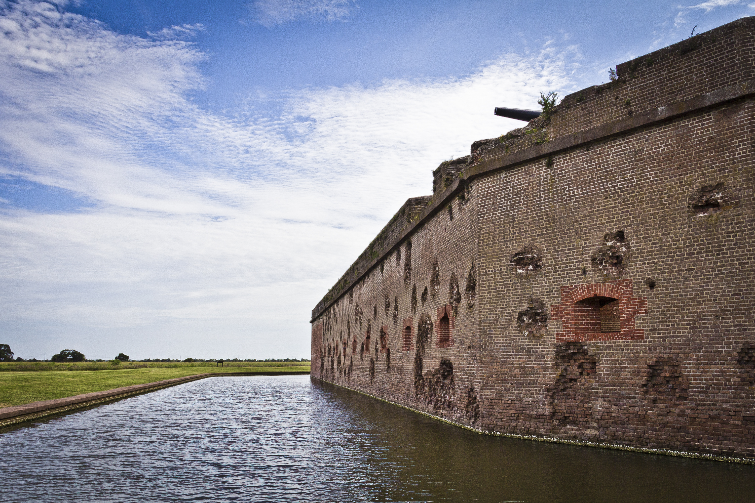
Fort Pulaski National Monument
National Monument
For much of the 19th century, masonry fortifications were the United States’ main defense against overseas enemies. However, during the Civil War, new technology proved its superiority over these fort...
18 mi from route
~44 min detour
$10
near mile 268.4
Park data from the National Park Service API. Alerts update every 2 hours.
Fuel & Cost
Regular Gas
$41.97 one way
$83.94 round trip
$3.97/gal25.4 MPG avg94 kg CO2
Fuel Type
$/gal
One Way
Round Trip
midgrade
$4.34
$45.89
$91.78
premium
$4.70
$49.68
$99.35
diesel
$5.61
$59.26
$118.52
No toll roads detected on this route.
Estimated Trip Cost (one way, 1 person)
Fuel
$42
Meals
$25–$50
Total
$67–$92
Rough estimate based on US averages. Hotel $80–$140/night, meals $25–$50/day.
Estimated CO2 emission: 93.9 kg one way.
Prices: EIA weekly data, 2026-04-13.
Driving Electric?
About $28 in charging
· 0 stops
· 67% less CO2
Vehicle Type
kWh
Stops
DC Fast
Home Charge
Average EV
80.5
0
$28.18
$12.88
Efficient EV
67.1
0
$23.48
$10.74
EV Truck/SUV
107.4
1
$37.58
$17.18
Gas CO2
94 kg
EV CO2
31 kg (67% less)
Plan for 0 charging stops, roughly every 270 miles. Allow 25-40 minutes per stop at a DC fast charger.
DC fast charging avg $0.35/kWh. Home charging avg $0.16/kWh. US grid CO2: 0.39 kg/kWh.
Travel Intel
Current conditions at both ends of the drive.
Forecast as of Apr 15, 2026
Origin
Gainesville, GA
Night
in Gainesville on Thursday
Local time
9:28 PM
EDT
Current temp
50°F
Unavailable
Live forecast
Destination
Georgetown, GA
Night
in Georgetown on Thursday
Local time
9:28 PM
EDT
Current temp
57°F
Unavailable
Live forecast
75°F
Washington, GA
134 mi in
Seasonal Notes
Summer travel usually means heavier construction, hotter rest stops, and busier weekend traffic around major cities.
Winter travel shortens daylight, so a route that looks manageable on paper can feel much longer after dark.
Holiday weekends tend to make both departure and arrival windows slower than the raw route time suggests.
Time zone
Same local time
Origin and destination are on the same clock, so arrival timing is easier to judge at a glance.
Temperature spread
7 degrees warmer at arrival
A meaningful temperature swing is a good cue to rethink layers, water, and how soon you want to arrive.
Road read
5h 30m on the road
An early start around 7-8 AM gets you there with plenty of daylight left.
Weather data from the National Weather Service. Conditions may change; check closer to your travel date.
Frequently Asked Questions
The drive from Gainesville, GA to Georgetown, GA covers 268.4 miles and takes about 5h 30m without stops. Add 15-30 minutes for a fuel or rest stop on longer drives.
The main roads are US 25, Jim Gillis Historic Savannah Parkway, Carl Sanders Highway. Expect a mix of highway and local road driving.
This is a comfortable same-day trip.
The midpoint is about 134.2 miles from Gainesville, GA. Look for rest areas, gas stations, or food options near the halfway mark.
At current regular gas prices, expect to spend about $41.97 one way. This estimate uses 25.4 MPG — your actual cost will vary with your vehicle's fuel efficiency and current gas prices.
An early start around 7-8 AM gets you there with plenty of daylight left. A late afternoon start means arriving after dark. Morning is better.
Plan about 1 meaningful break for fuel, food, or rest. Plan on a short reset every 3 to 4 hours to stay fresh behind the wheel.
This is a demanding drive. With 32 significant decision points across 268.4 miles, you will need to stay alert - especially through interchange areas and urban stretches. Consider splitting it into segments if you are not comfortable with fast highway navigation.
The main spots that need attention: at 40.2 miles (US 129; US 441; 10 Loop; 15 / Inner Loop 10): Exit ramp - move to the correct lane early. Lane positioning matters here. Multiple destination signs - pick the right one; at 42.7 miles: Exit ramp - move to the correct lane early. Lane positioning matters here. Multiple destination signs - pick the right one; at 107 miles: Lane positioning matters here.
On the drive from Gainesville, GA to Georgetown, GA, road signs begin pointing toward Lexington along the way.
Yes. Nearby national parks include Fort Pulaski National Monument.