The drive from Gastonia, NC to Morehead City, NC covers 303.1 miles and takes about 6h 32m behind the wheel.
This route is realistic as a one-day drive if you keep your stops efficient.
The route leans on NC Highway 49, Freedom Memorial Bridge, East New Bern Road for much of the mileage,
and the overall profile is mixed drive.
The longest uninterrupted segment is about 55.6 miles on NC Highway 49.
At current regular gas prices, budget about $47.40 one way before food or hotel costs.
Trip Pace
Same-day drive is realistic
A same-day return is possible, but it will make for a full day on the road.
Break Rhythm
1 planned break
Plan on a short reset every 3 to 4 hours to stay fresh behind the wheel.
Midpoint
151.5 miles from Gastonia, NC
A natural place for your longest stop of the day
, about 3h 28m into the drive
.
Who Is This Route For?
Weekend Trip
Doable as a same-day drive at 6h 32m. Total distance: 303.1 miles.
Family Friendly
Moderate complexity with 1 natural rest stops along the way.
Solo Traveler
6h 32m drive, plan rest stops for pacing.
Scenic Drive
Mixed drive route profile with national parks nearby.
Drive Character
The drive from Gastonia, NC to Morehead City, NC covers 303.1 miles and takes about 6h 32m, using a mix of highways and local roads.
Expect a mix of faster highway mileage and slower local approaches near the beginning or end.
There are about 32 navigation steps in the underlying route data, so the final approach matters more than the middle miles.
NC Highway 49 is the longest continuous segment at about 55.6 miles.
How Hard Is This Drive?
This route mixes highway mileage with some local-road sections near the start or finish. This route has several spots where lane changes, forks, or exits need your full attention. The trickiest moment comes around 0.7 miles in near NC 7 / East Long Avenue.
Driving Effort8/10
Demanding - plan breaks and stay ahead of the key maneuvers
Balances navigation complexity with total wheel time.
This is a demanding drive. With 18 significant decision points across 303.1 miles, you will need to stay alert - especially through interchange areas and urban stretches. Consider splitting it into segments if you are not comfortable with fast highway navigation.
Where does it get tricky?
The main spots that need attention: at 0.7 miles (NC 7 / East Long Avenue): Lane positioning matters here; at 25.6 miles: Exit ramp - move to the correct lane early. Lane positioning matters here. Multiple destination signs - pick the right one; at 25.9 miles: Highway fork - watch signs carefully.
Critical Maneuvers
5 of 18 key points
These are the spots where you need to pay the most attention. Preview them before you drive.
6
0.7 mi into trip|~1m in|NC 7 / East Long Avenue
Turn right onto NC 7 / East Long Avenue
Lane positioning matters here
Use the right lane.
8
25.6 mi into trip|~33m in
Take the exit toward University City Boulevard, Ikea Boulevard
Exit ramp - move to the correct lane early. Lane positioning matters here. Multiple destination signs - pick the right one
Use the slight right lane.
Exit 43
Toward University City Boulevard, Ikea Boulevar...
6
25.9 mi into trip|~33m in
Keep slight right at fork toward Ikea Boulevard
Highway fork - watch signs carefully
Toward Ikea Boulevard
6
122.4 mi into trip|~2h 52m in|US 64
Keep slight left at fork onto US 64
Highway fork - watch signs carefully. Lane positioning matters here
Use the straight lane.
6
143.4 mi into trip|~3h 19m in
Take the exit toward NC 540 Toll South
Exit ramp - move to the correct lane early. Lane positioning matters here
Place data sourced from public business listings. Hours and availability may vary.
National Parks Near This Route
Worth a detour if your schedule allows.
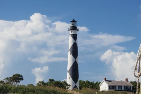
Cape Lookout National Seashore
National Seashore
A boat ride three miles off-shore brings you to the barrier islands of Cape Lookout National Seashore. Horse watching, shelling, fishing, birding, camping, lighthouse climbing, and touring historic vi...
23 mi from route
~57 min detour
Free
near mile 303.1
Station data from NREL Alternative Fuel Stations database.
Driving Electric?
About $32 in charging
· 1 stop
· 67% less CO2
Vehicle Type
kWh
Stops
DC Fast
Home Charge
Average EV
90.9
1
$31.83
$14.55
Efficient EV
75.8
0
$26.52
$12.12
EV Truck/SUV
121.2
1
$42.43
$19.40
Gas CO2
106 kg
EV CO2
35 kg (67% less)
Plan for 1 charging stop. A 30-minute DC fast charge mid-route should be enough to complete the trip comfortably.
DC fast charging avg $0.35/kWh. Home charging avg $0.16/kWh. US grid CO2: 0.39 kg/kWh.
Travel Intel
Current conditions at both ends of the drive.
Forecast as of Apr 15, 2026
Origin
Gastonia, NC
Late night
in Gastonia on Friday
Local time
1:22 AM
EDT
Current temp
74°F
Unavailable
Live forecast
Destination
Morehead City, NC
Late night
in Morehead City on Friday
Local time
1:22 AM
EDT
Current temp
51°F
Unavailable
Live forecast
Seasonal Notes
Summer travel usually means heavier construction, hotter rest stops, and busier weekend traffic around major cities.
Winter travel shortens daylight, so a route that looks manageable on paper can feel much longer after dark.
Holiday weekends tend to make both departure and arrival windows slower than the raw route time suggests.
Time zone
Same local time
Origin and destination are on the same clock, so arrival timing is easier to judge at a glance.
Temperature spread
23 degrees cooler at arrival
A meaningful temperature swing is a good cue to rethink layers, water, and how soon you want to arrive.
Road read
6h 32m on the road
Start early — leave by 6-7 AM to arrive at a reasonable hour.
Weather data from the National Weather Service. Conditions may change; check closer to your travel date.
Frequently Asked Questions
The drive from Gastonia, NC to Morehead City, NC covers 303.1 miles and takes about 6h 32m without stops. Add 15-30 minutes for a fuel or rest stop on longer drives.
The main roads are NC Highway 49, Freedom Memorial Bridge, East New Bern Road. Expect a mix of highway and local road driving.
This is a comfortable same-day trip.
The midpoint is about 151.5 miles from Gastonia, NC. Look for rest areas, gas stations, or food options near the halfway mark.
At current regular gas prices, expect to spend about $47.40 one way. This estimate uses 25.4 MPG — your actual cost will vary with your vehicle's fuel efficiency and current gas prices.
Start early — leave by 6-7 AM to arrive at a reasonable hour. This is a long drive — plan for a morning departure or consider splitting it into two days.
Plan about 1 meaningful break for fuel, food, or rest. Plan on a short reset every 3 to 4 hours to stay fresh behind the wheel.
This is a demanding drive. With 18 significant decision points across 303.1 miles, you will need to stay alert - especially through interchange areas and urban stretches. Consider splitting it into segments if you are not comfortable with fast highway navigation.
The main spots that need attention: at 0.7 miles (NC 7 / East Long Avenue): Lane positioning matters here; at 25.6 miles: Exit ramp - move to the correct lane early. Lane positioning matters here. Multiple destination signs - pick the right one; at 25.9 miles: Highway fork - watch signs carefully.
The route from Gastonia, NC to Morehead City, NC does not surface many named destination signs beyond the main corridor.