The drive from Gering, NE to Beatrice, NE covers 424.5 miles and takes about 7h 47m behind the wheel.
This route is realistic as a one-day drive if you keep your stops efficient.
The route leans on I 80, US 26, Highway 103 for much of the mileage,
and the overall profile is highway-focused drive.
The longest uninterrupted segment is about 241.8 miles on I 80.
At current regular gas prices, budget about $66.37 one way before food or hotel costs.
Trip Pace
Same-day drive is realistic
A same-day return is possible, but it will make for a full day on the road.
Break Rhythm
2 planned breaks
Plan on a short reset every 3 to 4 hours to stay fresh behind the wheel.
Midpoint
212.3 miles from Gering, NE
A natural place for your longest stop of the day
, about 3h 58m into the drive
.
Who Is This Route For?
Weekend Trip
Doable as a same-day drive at 7h 47m. Total distance: 424.5 miles.
Family Friendly
Moderate complexity with 2 natural rest stops along the way.
This is a 7h 47m highway drive covering 424.5 miles, with most of the trip on I 80 and US 26. The longest continuous stretch is about 241.8 miles on I 80.
Most of the miles stay on highways, which makes pacing and fuel planning easier than turn-by-turn city driving.
There are about 28 navigation steps in the underlying route data, so the final approach matters more than the middle miles.
I 80 is the longest continuous segment at about 241.8 miles.
How Hard Is This Drive?
This is a straightforward highway drive that stays mostly on I 80 and US 26. There are only a few real navigation decisions along the way. The trickiest moment comes early in the drive near 10th Street.
Driving Effort4/10
Easy - simple navigation with a manageable amount of wheel time
Balances navigation complexity with total wheel time.
The route itself is not hard, but at 7h 47m, endurance matters. Plan breaks every 2-3 hours. The 18 decision points are all manageable with basic attention.
Where does it get tricky?
The main spots that need attention: near the start (10th Street): Navigation decision point; at 0.3 miles (M Street): Navigation decision point; at 116.7 miles (North Spruce Street): Navigation decision point.
Critical Maneuvers
5 of 18 key points
These are the spots where you need to pay the most attention. Preview them before you drive.
5
0 mi into trip|~0m in|10th Street
Turn right onto 10th Street
Navigation decision point
4
0.3 mi into trip|~1m in|M Street
Turn left onto M Street
Navigation decision point
4
116.7 mi into trip|~2h 19m in|North Spruce Street
Turn right onto North Spruce Street
Navigation decision point
4
119.4 mi into trip|~2h 24m in|US 26; US 30; N-61; I 80 Alt
Turn left onto US 26; US 30; N-61; I 80 Alt
Navigation decision point
5
424.5 mi into trip|~7h 47m in
Turn right
Navigation decision point
Main Roads
Road
Distance
Duration
I 80
241.8 mi
4h 1m
US 26
84 mi
1h 39m
Highway 103
22.4 mi
26m
Highway 92
17.4 mi
20m
US Highway 26
12.5 mi
15m
Highway 33
10 mi
11m
West Highway 4
8.6 mi
11m
420th Road
8.4 mi
9m
Longest stretch:
I 80
— 241.8 mi, about 4h 1m
Turn-by-Turn Driving Directions
Step-by-step road directions between Gering, NE and Beatrice, NE.
1
Start on Q Street
39 ft·5 sec·Q Street
2
Turn right onto 10th Street
0.3 mi·1 min·10th Street
3
Turn left onto M Street
0.7 mi·1 min·M Street
4
Continue on Old Oregon Trail
0.7 mi·1 min·Old Oregon Trail
5
Continue on N-92
17 mi·20 min·Highway 92
6
Continue on US 26; N-92
13 mi·15 min·US Highway 26
7
Turn left onto US 26; US 385
1.0 mi·1 min·Main Street
8
Continue on US 26
84 mi·1 hr 39 min·US 26
9
Turn right onto North Spruce Street
2.7 mi·4 min·North Spruce Street
10
Turn left onto US 26; US 30; N-61; I 80 Alt
305 ft·7 sec·US 26; US 30; N-61; I 80 Alt
11
Turn right onto US 26; N-61
0.9 mi·1 min·South Highway 26/61
12
Turn left
0.4 mi·52 sec
Toward I 80 east
13
Merge onto I 80
242 mi·4 hr 1 min·I 80
14
Take the exit
0.3 mi·40 sec
Toward NE 80E Link: Beaver Crossing
15
Turn right onto L-80E
8.4 mi·9 min·420th Road
16
Continue on L-80E
3.0 mi·3 min·Highway 80E
17
Turn left onto US 6
1.0 mi·1 min·1st Street
18
Continue on US 6
5.6 mi·6 min·Highway 6
19
Turn right onto N-33
10.0 mi·11 min·Highway 33
20
Turn right onto N-103
9.5 mi·11 min·Highway 103
21
Continue on N-103
1.1 mi·2 min·North Main Street
22
Continue on N-103
13 mi·15 min·Highway 103
23
At end of road, turn left onto N-4
8.6 mi·11 min·West Highway 4
24
Turn left onto US 136; N-4
1.4 mi·3 min·West Court Street
25
Turn left onto North 5th Street
0.2 mi·33 sec·North 5th Street
26
Turn right
58 ft·6 sec
27
Turn right
348 ft·25 sec
28
Arrive at destination
Trip Plan
Morning Departure
Start early — leave by 6-7 AM to arrive at a reasonable hour.
Evening Departure
This is a long drive — plan for a morning departure or consider splitting it into two days.
You can normally do this drive in one day.
Plan roughly 2 meaningful breaks for fuel, food, and rest.
The halfway point lands around 212.3 miles from Gering, NE, or about 3h 58m into the drive.
The longest continuous stretch on this route runs about 241.8 miles.
This is a comfortable same-day trip.
Departure
Before you leave
Start with fuel, water, and navigation already sorted so the first hour feels easy.
First stop
Around 93 miles or 1h 52m in
Use this first pause for coffee, a restroom break, and a quick traffic check ahead.
Halfway reset
Around 212.3 miles or 3h 58m in
This is the best place for your longest stop, a real meal, and a full fuel check.
Final approach
Final hour starts around 6h 31m
Traffic, exits, and arrival timing usually matter more near Beatrice, NE than in the middle of the route.
Before You Leave
+
Open the route before leaving Gering, NE so your first major turns are already loaded.
+
Leave with enough water and a charging cable within reach, not packed away.
+
Check your fuel range against the first long segment, especially if you are starting outside city service areas.
+
Pick one backup stop option before the midpoint in case traffic changes your pacing.
Day 1
Settle into the route from Gering, NE
This is one driving day of about 424.5 miles and 7h 47m.
Your first comfortable stop window is around 93 miles from Gering, NE.
This route can stay practical as a one-day drive if traffic stays reasonable.
Plan about 2 real breaks rather than only quick fuel stops.
The longest stretch is on I 80 for about 241.8 miles.
Where to Stop
Rest stops, refuel points, and overnight suggestions along this route.
Halfway Point
Midpoint
About 212.3 mi from Gering, NE
· 3h 58m into the drive
The midpoint is around 212.3 miles from Gering, NE, which is a good place for a longer meal and fuel stop.
Before the longest stretch
Fuel check
Top up before I 80 if your tank is already low. That segment runs about 241.8 miles.
Arriving in Beatrice, NE
The final approach into Beatrice, NE usually feels slower than the middle of the drive, so avoid planning your tightest schedule at the very end.
Try to arrive with enough fuel left to skip an immediate station stop unless you already know the area around Beatrice, NE.
After long uninterrupted mileage, take five minutes before the last urban segment to reset and refocus on exits, merges, and city traffic.
These stop ideas are pacing suggestions — the exact town or exit can change with traffic, hotel plans, and fuel range.
National Parks Near This Route
Worth a detour if your schedule allows.
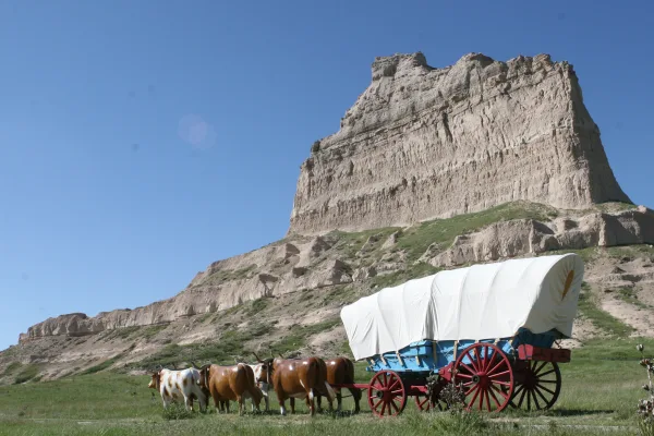
Scotts Bluff National Monument
National Monument
Towering 800 feet above the North Platte River, Scotts Bluff has served as a landmark for peoples from Native Americans to emigrants on the Oregon, California and Mormon Trails to modern travelers. Ri...
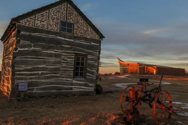
The Homestead Act of 1862 transformed the world. Millions were invited to file claims including families, women, immigrants, and formerly enslaved people. Over 10 percent of the United States was home...
5 mi from route
~12 min detour
Free
near mile 424.5
Park data from the National Park Service API. Alerts update every 2 hours.
Fuel & Cost
Regular Gas
$66.37 one way
$132.73 round trip
$3.97/gal25.4 MPG avg149 kg CO2
Fuel Type
$/gal
One Way
Round Trip
midgrade
$4.36
$72.87
$145.73
premium
$4.89
$81.69
$163.38
diesel
$5.61
$93.72
$187.45
No toll roads detected on this route.
Estimated Trip Cost (one way, 1 person)
Fuel
$66
Meals
$25–$50
Total
$91–$116
Rough estimate based on US averages. Hotel $80–$140/night, meals $25–$50/day.
Estimated CO2 emission: 148.5 kg one way.
Prices: EIA weekly data, 2026-04-13.
Driving Electric?
About $45 in charging
· 1 stop
· 66% less CO2
Vehicle Type
kWh
Stops
DC Fast
Home Charge
Average EV
127.4
1
$44.57
$20.38
Efficient EV
106.1
1
$37.14
$16.98
EV Truck/SUV
169.8
2
$59.43
$27.17
Gas CO2
149 kg
EV CO2
50 kg (66% less)
Plan for 1 charging stop. A 30-minute DC fast charge mid-route should be enough to complete the trip comfortably.
DC fast charging avg $0.35/kWh. Home charging avg $0.16/kWh. US grid CO2: 0.39 kg/kWh.
Travel Intel
Current conditions at both ends of the drive.
Forecast as of Apr 15, 2026
Origin
Gering, NE
Morning
in Gering on Friday
Local time
7:20 AM
MDT
Current temp
46°F
Unavailable
Live forecast
Destination
Beatrice, NE
Morning
in Beatrice on Friday
Local time
8:20 AM
CDT
Current temp
78°F
Unavailable
Live forecast
Seasonal Notes
Summer travel usually means heavier construction, hotter rest stops, and busier weekend traffic around major cities.
Winter travel shortens daylight, so a route that looks manageable on paper can feel much longer after dark.
Holiday weekends tend to make both departure and arrival windows slower than the raw route time suggests.
Time zone
1 hour later
The destination clock does not match departure time, so double-check hotel check-in windows and late arrival plans.
Temperature spread
32 degrees warmer at arrival
A meaningful temperature swing is a good cue to rethink layers, water, and how soon you want to arrive.
Road read
7h 47m on the road
Start early — leave by 6-7 AM to arrive at a reasonable hour.
Weather data from the National Weather Service. Conditions may change; check closer to your travel date.
Frequently Asked Questions
The drive from Gering, NE to Beatrice, NE covers 424.5 miles and takes about 7h 47m without stops. Add 15-30 minutes for a fuel or rest stop on longer drives.
The main roads are I 80, US 26, Highway 103. Most of the drive stays on highways, so watch for ramps and exits.
This is a comfortable same-day trip.
The midpoint is about 212.3 miles from Gering, NE. Look for rest areas, gas stations, or food options near the halfway mark.
At current regular gas prices, expect to spend about $66.37 one way. This estimate uses 25.4 MPG — your actual cost will vary with your vehicle's fuel efficiency and current gas prices.
Start early — leave by 6-7 AM to arrive at a reasonable hour. This is a long drive — plan for a morning departure or consider splitting it into two days.
Plan about 2 meaningful breaks for fuel, food, or rest. Plan on a short reset every 3 to 4 hours to stay fresh behind the wheel.
The route itself is not hard, but at 7h 47m, endurance matters. Plan breaks every 2-3 hours. The 18 decision points are all manageable with basic attention.
The main spots that need attention: near the start (10th Street): Navigation decision point; at 0.3 miles (M Street): Navigation decision point; at 116.7 miles (North Spruce Street): Navigation decision point.
The route from Gering, NE to Beatrice, NE does not surface many named destination signs beyond the main corridor.
Yes. Nearby national parks include Scotts Bluff National Monument and Homestead National Historical Park.
How this page is built
Compiled and maintained by the Trip.ovh planning team at COD Solutions Oy (Helsinki). Each route is built from authoritative open government and mapping datasets rather than crowdsourced reviews. Distances and geometry come from
OSRM
over
OpenStreetMap.
Fuel cost uses
EIA
weekly regional averages.
National park proximity is from the
NPS API.
Pages are published only after passing our data-quality checks; our
methodology page
documents refresh cadence, editorial standards, and known limitations.