This 292.8-mile journey from Jacksonville, FL to Alva, FL is a solid day trip, estimated to take around 6 hours of driving time. The route predominantly sticks to highways, with a 94% highway share, making it a straightforward drive. You can expect to spend approximately $47 on fuel for this trip. With only one recommended stop, it's designed for efficiency. This drive is entirely within Florida, moving from the northern part of the state down towards the southern interior.
Trip Pace
Same-day drive is realistic
A same-day return is possible, but it will make for a full day on the road.
Break Rhythm
1 planned break
Plan on a short reset every 3 to 4 hours to stay fresh behind the wheel.
Midpoint
146.4 miles from Jacksonville, FL
A natural place for your longest stop of the day
, about 2h 49m into the drive
.
Loading map...
Drive Character
Expect a highway-focused drive for most of this 6-hour trip, as 94% of the route utilizes major roadways like US 27 and I-4. The majority of your time will be spent on these faster roads, with one significant stretch of 97.8 miles on US 27 where you'll cover considerable ground without needing to exit. While primarily highway, the transition between these main arteries will offer a change of pace, but the overall character remains geared towards covering distance efficiently.
Most of the miles stay on highways, which makes pacing and fuel planning easier than turn-by-turn city driving.
There are about 31 navigation steps in the underlying route data, so the final approach matters more than the middle miles.
US 27 is the longest continuous segment at about 97.8 miles.
How Hard Is This Drive?
This is a straightforward highway drive that stays mostly on US 27 and I 95. This route has several spots where lane changes, forks, or exits need your full attention. The trickiest moment comes around 2.3 miles in.
Route Complexity9/10
High effort - long or complex enough to need steady focus all day
This is a demanding drive. With 18 significant decision points across 292.8 miles, you will need to stay alert — especially through interchange areas and urban stretches. Consider splitting it into segments if you are not comfortable with fast highway navigation.
Where does it get tricky?
The main spots that need attention: at 2.3 miles: Highway fork - watch signs carefully. Lane positioning matters here; at 88.9 miles: Exit ramp - move to the correct lane early. Lane positioning matters here. Multiple destination signs - pick the right one; at 90.5 miles: Highway fork - watch signs carefully. Lane positioning matters here.
Critical Maneuvers
5 of 18 key points
These are the spots where you need to pay the most attention. Preview them before you drive.
8
2.3 mi into trip|~5m in
Keep slight left at fork toward I 95 South: Daytona Beach
Highway fork - watch signs carefully. Lane positioning matters here
Use the straight lane.
Toward I 95 South: Daytona Beach
8
88.9 mi into trip|~1h 40m in
Take the exit toward I 4, US 92, FL 400: Daytona Beach, Orlando, International Airport, International Speedway
Exit ramp - move to the correct lane early. Lane positioning matters here. Multiple destination signs - pick the right one
Use the straight / slight right lanes.
Exit 260C-B-A
Toward I 4, US 92, FL 400: Daytona Beach, Orlan...
8
90.5 mi into trip|~1h 43m in
Keep slight right at fork toward I 4 West: Orlando
Highway fork - watch signs carefully. Lane positioning matters here
Use the slight right lane.
Exit 260B
Toward I 4 West: Orlando
7
138.1 mi into trip|~2h 38m in
Take the exit toward Ivanhoe Boulevard
Exit ramp - move to the correct lane early. Lane positioning matters here
Use the slight right lane.
Exit 84B
Toward Ivanhoe Boulevard
8
167.9 mi into trip|~3h 15m in
Take the exit toward US 27: Haines City, Clermont
Exit ramp - move to the correct lane early. Lane positioning matters here. Multiple destination signs - pick the right one
Use the straight / right lanes.
Exit 55
Toward US 27: Haines City, Clermont
Towns Mentioned on Route Signs
Based on OSRM destination-sign hints, not a full list of every settlement the road passes.
Between Jacksonville, FL and Alva, FL, road signs point toward Orlando, International Airport, International Speedway, Daytona and Clermont.
Orlando
88.9 mi in|~1h 40m
International Airport
88.9 mi in|~1h 40m
International Speedway
88.9 mi in|~1h 40m
Daytona
89.3 mi in|~1h 41m
Clermont
167.9 mi in|~3h 15m
Main Roads
Road
Distance
Duration
US 27
97.8 mi
2h 7m
I 95
86.4 mi
1h 34m
I 4
75.8 mi
1h 28m
FL 29
14 mi
18m
Hickpochee Avenue
12.1 mi
16m
US 1
1.1 mi
2m
Main Street
0.5 mi
1m
Broadway Street
0.5 mi
<1m
Longest stretch:
US 27
— 97.8 mi, about 2h 7m
Turn-by-Turn Driving Directions
Step-by-step road directions between Jacksonville, FL and Alva, FL.
1
Start on US 17
0.1 mi·20 sec·Union Street
2
Turn right onto Newnan Street
0.4 mi·1 min·Newnan Street
3
Turn right onto FL 228
0.1 mi·23 sec·East Forsyth Street
4
Turn left onto US 1; US 90
0.5 mi·1 min·Main Street
5
Take the ramp onto US 1; US 90
0.9 mi·2 min·US 1; US 90
Toward I 95 South
6
Keep slight right at fork onto US 1
0.2 mi·28 sec·US 1
Toward I 95, US 1 South, FL 5 South: Daytona Beach, Philips Highway
7
Keep slight left at fork
0.2 mi·26 sec
Toward I 95 South: Daytona BeachUse the straight lane.
8
Merge onto I 95
86 mi·1 hr 34 min·I 95
Use the straight / slight right lanes.
9
Take the exit
0.3 mi·35 sec
Exit 260C-B-A Toward I 4, US 92, FL 400: Daytona Beach, Orlando, International Airport, International SpeedwayUse the straight / slight right lanes.
10
Continue on this road
513 ft·12 sec·this road
Exit 260 C B AToward I 4, US 92, FL 400: Daytona Beach, Orlando
11
Keep slight left at fork
1.3 mi·1 min
Toward I 4, FL 400: Orlando, South Daytona
12
Keep slight right at fork
0.6 mi·1 min
Exit 260BToward I 4 West: OrlandoUse the slight right lane.
13
Continue on I 4
37 mi·40 min·I 4
Use the straight / slight right lanes.
14
Keep slight right at fork onto I 4
10 mi·13 min·I 4
Use the straight / slight left lanes.
15
Take the exit
0.3 mi·43 sec
Exit 84BToward Ivanhoe BoulevardUse the slight right lane.
16
Continue on this road
0.5 mi·1 min·this road
Toward I 4 West: Tampa
17
Continue on this road
0.3 mi·34 sec·this road
Toward I 4 West: Tampa
18
Merge onto I 4
29 mi·34 min·I 4
Use the straight / slight right lanes.
19
Take the exit
0.5 mi·1 min
Exit 55Toward US 27: Haines City, ClermontUse the straight / right lanes.
20
Turn right onto US 27
3.8 mi·5 min·US 27
Use the right lane.
21
Continue on US 27
0.4 mi·36 sec·US 27
22
Continue on US 27
0.2 mi·18 sec·US 27
Use the left lane.
23
Continue on US 27
2.7 mi·3 min·US 27
24
Continue on US 27
0.9 mi·1 min·US 27
25
Continue on US 27
39 mi·50 min·US 27
Use the left lane.
26
Continue on US 27; US 98
10 mi·14 min·US 27; US 98
Use the left lane.
27
Continue on US 27; US 98
41 mi·50 min·US 27; US 98
Use the left lane.
28
Turn right onto FL 29
14 mi·18 min·FL 29
29
Turn right onto FL 29; FL 80
12 mi·16 min·Hickpochee Avenue
Use the left lane.
30
Turn right onto Broadway Street
0.5 mi·48 sec·Broadway Street
31
Arrive at destination
Broadway Street
Trip Plan
Starting your 6-hour drive from Jacksonville early in the morning will help you beat potential traffic and maximize daylight for the 292.8-mile trek to Alva. With a fuel cost estimated at $47, it's wise to fill up before departing. The longest stretch without a major interruption is 97.8 miles on US 27, so plan your stops accordingly, keeping in mind only one is generally recommended. Given this is a single-day drive, you have flexibility, but staying on schedule is key to arriving in Alva at a reasonable hour.
Morning Departure
Start early — leave by 6-7 AM to arrive at a reasonable hour.
Evening Departure
This is a long drive — plan for a morning departure or consider splitting it into two days.
You can normally do this drive in one day.
Plan roughly 1 meaningful break for fuel, food, and rest.
The halfway point lands around 146.4 miles from Jacksonville, FL, or about 2h 49m into the drive.
The longest continuous stretch on this route runs about 97.8 miles.
This is a comfortable same-day trip.
Departure
Before you leave
Start with fuel, water, and navigation already sorted so the first hour feels easy.
First stop
Around 80 miles or 1h 31m in
Use this first pause for coffee, a restroom break, and a quick traffic check ahead.
Halfway reset
Around 146.4 miles or 2h 49m in
This is the best place for your longest stop, a real meal, and a full fuel check.
Final approach
Final hour starts around 4h 51m
Traffic, exits, and arrival timing usually matter more near Alva, FL than in the middle of the route.
Before You Leave
+
Open the route before leaving Jacksonville, FL so your first major turns are already loaded.
+
Leave with enough water and a charging cable within reach, not packed away.
+
Check your fuel range against the first long segment, especially if you are starting outside city service areas.
Day 1
Settle into the route from Jacksonville, FL
This is one driving day of about 292.8 miles and 6h.
Your first comfortable stop window is around 80 miles from Jacksonville, FL.
This route can stay practical as a one-day drive if traffic stays reasonable.
Plan about 1 real break rather than only quick fuel stops.
The longest stretch is on US 27 for about 97.8 miles.
Where to Stop
Rest stops, refuel points, and overnight suggestions along this route.
Halfway Point
Midpoint
About 146.4 mi from Jacksonville, FL
· 2h 49m into the drive
The midpoint is around 146.4 miles from Jacksonville, FL, which is a good place for a longer meal and fuel stop.
Before the longest stretch
Fuel check
Top up before US 27 if your tank is already low. That segment runs about 97.8 miles.
Arriving in Alva, FL
The final approach into Alva, FL usually feels slower than the middle of the drive, so avoid planning your tightest schedule at the very end.
Try to arrive with enough fuel left to skip an immediate station stop unless you already know the area around Alva, FL.
These stop ideas are pacing suggestions — the exact town or exit can change with traffic, hotel plans, and fuel range.
National Parks Near This Route
Worth a detour if your schedule allows.
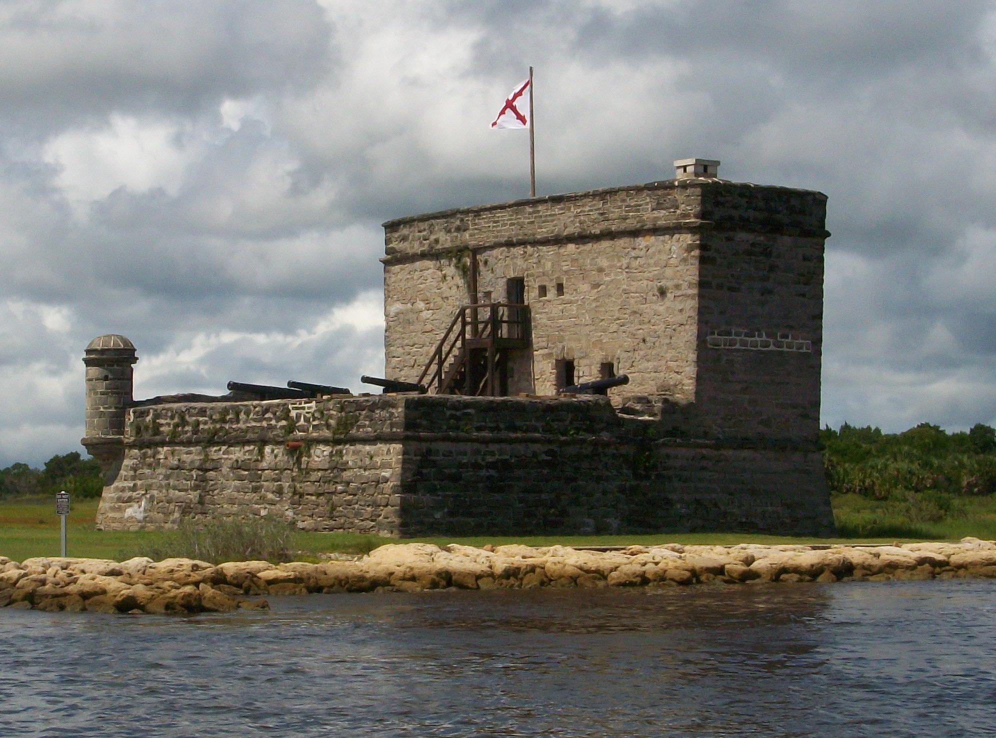
Fort Matanzas National Monument
National Monument
Fort Matanzas National Monument preserves the fortified coquina watchtower, completed in 1742, which defended the southern approach to the Spanish military settlement of St. Augustine. It also protect...
5 mi from route
~14 min detour
Free
near mile 50.5
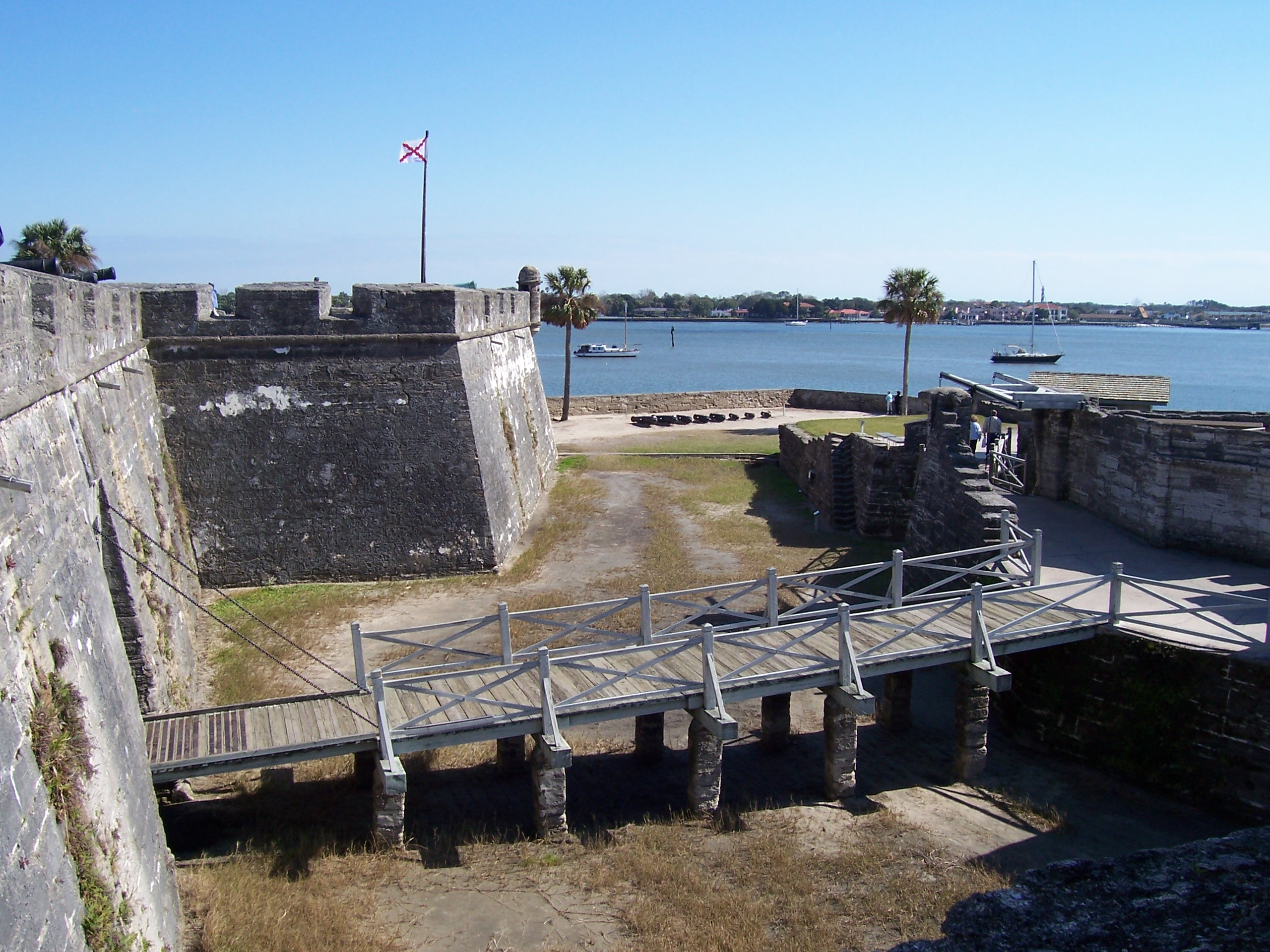
Built by the Spanish in St. Augustine to defend Florida and the Atlantic trade route, Castillo de San Marcos National Monument preserves the oldest masonry fortification in the continental United Stat...
Station data from NREL Alternative Fuel Stations database.
Driving Electric?
About $31 in charging
· 1 stop
· 67% less CO2
Vehicle Type
kWh
Stops
DC Fast
Home Charge
Average EV
87.8
1
$30.74
$14.05
Efficient EV
73.2
0
$25.62
$11.71
EV Truck/SUV
117.1
1
$40.99
$18.74
Gas CO2
102 kg
EV CO2
34 kg (67% less)
Plan for 1 charging stop. A 30-minute DC fast charge mid-route should be enough to complete the trip comfortably.
DC fast charging avg $0.35/kWh. Home charging avg $0.16/kWh. US grid CO2: 0.39 kg/kWh.
Travel Intel
Current conditions at both ends of the drive.
Forecast data refreshed 3 days ago
Origin
Jacksonville, FL
Late night
in Jacksonville on Wednesday
Local time
3:32 AM
EDT
Current temp
66°F
Unavailable
Live forecast
Destination
Alva, FL
Late night
in Alva on Wednesday
Local time
3:32 AM
EDT
Current temp
64°F
Unavailable
Live forecast
63°F
Eagle Lake, FL
146 mi in
Seasonal Notes
Summer travel usually means heavier construction, hotter rest stops, and busier weekend traffic around major cities.
Winter travel shortens daylight, so a route that looks manageable on paper can feel much longer after dark.
Holiday weekends tend to make both departure and arrival windows slower than the raw route time suggests.
Time zone
Same local time
Origin and destination are on the same clock, so arrival timing is easier to judge at a glance.
Temperature spread
2 degrees cooler at arrival
A meaningful temperature swing is a good cue to rethink layers, water, and how soon you want to arrive.
Road read
6h on the road
Start early — leave by 6-7 AM to arrive at a reasonable hour.
Weather data from the National Weather Service. Conditions may change; check closer to your travel date.
Frequently Asked Questions
The drive from Jacksonville, FL to Alva, FL covers 292.8 miles and takes about 6h without stops. Add 15-30 minutes for a fuel or rest stop on longer drives.
The main roads are US 27, I 95, I 4. Most of the drive stays on highways, so watch for ramps and exits.
This is a comfortable same-day trip.
The midpoint is about 146.4 miles from Jacksonville, FL. Look for rest areas, gas stations, or food options near the halfway mark.
At current regular gas prices, expect to spend about $46.61 one way. This estimate uses 25.4 MPG — your actual cost will vary with your vehicle's fuel efficiency and current gas prices.
Start early — leave by 6-7 AM to arrive at a reasonable hour. This is a long drive — plan for a morning departure or consider splitting it into two days.
Plan about 1 meaningful break for fuel, food, or rest. Plan on a short reset every 3 to 4 hours to stay fresh behind the wheel.
This is a demanding drive. With 18 significant decision points across 292.8 miles, you will need to stay alert — especially through interchange areas and urban stretches. Consider splitting it into segments if you are not comfortable with fast highway navigation.
The main spots that need attention: at 2.3 miles: Highway fork - watch signs carefully. Lane positioning matters here; at 88.9 miles: Exit ramp - move to the correct lane early. Lane positioning matters here. Multiple destination signs - pick the right one; at 90.5 miles: Highway fork - watch signs carefully. Lane positioning matters here.
Between Jacksonville, FL and Alva, FL, road signs point toward Orlando, International Airport, International Speedway, Daytona and Clermont.