The drive from Kalispell, MT to Baker, MT covers 647.4 miles and takes about 12h 20m behind the wheel.
It usually feels better as a 2-day road trip than as one long push.
The route leans on US Highway 87, US Route 2, US 87 for much of the mileage,
and the overall profile is long-distance drive.
The longest uninterrupted segment is about 196.5 miles on US Highway 87.
At current regular gas prices, budget about $102.59 one way before food or hotel costs.
Trip Pace
Best split across 2 days
Treat the return leg as its own travel day rather than an afterthought.
Break Rhythm
3 planned breaks
Plan on a short reset every 3 to 4 hours to stay fresh behind the wheel.
Midpoint
323.7 miles from Kalispell, MT
A natural place for your longest stop of the day
, about 6h 9m into the drive
.
Who Is This Route For?
Family Friendly
Moderate complexity with 3 natural rest stops along the way.
Solo Traveler
12h 20m drive, plan rest stops for pacing.
Drive Character
At 647.4 miles and 12h 20m of driving, this is a route where fuel stops, weather, and timing matter more than any single turn. The main roads are US Highway 87 and US Route 2.
Most of the miles stay on highways, which makes pacing and fuel planning easier than turn-by-turn city driving.
There are about 49 navigation steps in the underlying route data, so the final approach matters more than the middle miles.
US Highway 87 is the longest continuous segment at about 196.5 miles.
How Hard Is This Drive?
This is a straightforward highway drive that stays mostly on US Highway 87 and US Route 2. You will hit about 25 points where you need to pay attention to lane position or signs. The trickiest moment comes around 0.2 miles in near 3rd Avenue East.
Driving Effort6/10
Moderate - straightforward overall, but long enough or busy enough to require pacing
Balances navigation complexity with total wheel time.
This drive requires moderate attention. Across 647.4 miles you will encounter 25 spots where lane choice or exit timing matters. Not difficult for experienced highway drivers, but worth previewing the tricky sections before you go.
Where does it get tricky?
The main spots that need attention: at 0.2 miles (3rd Avenue East): Navigation decision point; at 0.3 miles (2nd Street East): Navigation decision point; at 8.1 miles (MT 206): Lane positioning matters here.
Critical Maneuvers
5 of 25 key points
These are the spots where you need to pay the most attention. Preview them before you drive.
5
0.2 mi into trip|~0m in|3rd Avenue East
Turn left onto 3rd Avenue East
Navigation decision point
5
0.3 mi into trip|~0m in|2nd Street East
Turn right onto 2nd Street East
Navigation decision point
6
8.1 mi into trip|~13m in|MT 206
Turn left onto MT 206
Lane positioning matters here
Use the left lane.
5
17.8 mi into trip|~25m in|US 2
At end of road, turn right onto US 2
Navigation decision point
5
601.7 mi into trip|~11h 11m in
Take the exit toward MT 261: Wibaux, Baker
Exit ramp - move to the correct lane early. Multiple destination signs - pick the right one
Toward MT 261: Wibaux, Baker
Main Roads
Road
Distance
Duration
US Highway 87
196.5 mi
3h 34m
US Route 2
81.3 mi
1h 32m
US 87
79 mi
1h 25m
US 89
76.4 mi
1h 26m
State Highway 7
44.3 mi
1h 5m
MT 200 S
43.4 mi
46m
I 94
29.8 mi
27m
10th Avenue South
22.6 mi
25m
Longest stretch:
US Highway 87
— 196.5 mi, about 3h 34m
Turn-by-Turn Driving Directions
Step-by-step road directions between Kalispell, MT and Baker, MT.
1
Start on 3rd Street West
0.2 mi·39 sec·3rd Street West
Use the straight / right lanes.
2
Turn left onto 3rd Avenue East
366 ft·12 sec·3rd Avenue East
3
Turn right onto 2nd Street East
0.2 mi·33 sec·2nd Street East
4
Continue on Conrad Drive
0.3 mi·45 sec·Conrad Drive
5
Turn left onto Woodland Park Drive
0.4 mi·1 min·Woodland Park Drive
6
Turn right onto US 2
1.2 mi·2 min·US Route 2
7
Turn straight onto MT 35
2.4 mi·3 min·State Highway 35
Use the right lane.
8
Continue on MT 35
3.3 mi·4 min·MT 35
9
Turn left onto MT 206
9.7 mi·12 min·MT 206
Use the left lane.
10
At end of road, turn right onto US 2
1.7 mi·2 min·US 2
11
Continue on US 2
80 mi·1 hr 30 min·US Route 2
12
Enter roundabout onto US 2; US 89
24 ft·0 sec·US 2; US 89
13
Continue on US 2; US 89
3.7 mi·6 min·US 2; US 89
14
Turn straight onto US 89
68 mi·1 hr 16 min·US 89
15
Enter roundabout onto US 89
526 ft·19 sec·1st Street Southwest
16
Continue on US 89
107 ft·1 sec·1st Street Southwest
17
Turn straight onto US 89
0.7 mi·1 min·Main Avenue South
18
Continue on US 89
17 mi·18 min·United States Route 89
19
Continue on US 89
15 mi·15 min·1st Road Southeast
20
At end of road, turn left onto US 89; MT 200
7.9 mi·9 min·US 89; MT 200
21
Take the exit onto US 89; MT 200
0.3 mi·32 sec·US 89; MT 200
Toward I 15 South: Great Falls
22
Merge onto I 15; US 89; MT 200
9.5 mi·8 min·First Special Service Force Memorial Highway
23
Take the exit onto I 15 Business
0.2 mi·30 sec·I 15 Business
Toward I 15 Business
24
Turn left onto I 15 Business
1.5 mi·1 min·Central Avenue West
25
Continue on I 15 Business
0.2 mi·17 sec·First Avenue North Bridge
26
Continue on I 15 Business
1.2 mi·2 min·1st Avenue North
27
Turn right onto US 87
0.8 mi·1 min·14th Street North
28
Turn left onto US 87; US 89; MT 3; MT 200
23 mi·25 min·10th Avenue South
29
Enter roundabout
224 ft·2 sec
30
Continue
0.3 mi·20 sec
31
Turn straight onto US 87; MT 3; MT 200
64 mi·1 hr 9 min·US 87; MT 3; MT 200
32
Continue on US 87; US 191; MT 200
15 mi·15 min·US 87; US 191; MT 200
33
Turn straight onto US 191
2.6 mi·3 min·Truck Bypass
34
Continue on 1st Avenue North
0.3 mi·37 sec·1st Avenue North
35
Turn left onto US 87; MT 200
0.4 mi·1 min·East Main Street
36
Continue on US 87; MT 200
1.1 mi·2 min·Northeast Main Street
37
Continue on US 87; MT 200
196 mi·3 hr 34 min·US Highway 87
38
Continue on MT 200 S
43 mi·46 min·MT 200 S
39
Continue on MT 200S
520 ft·14 sec·MT 200S
40
Take the ramp
0.2 mi·29 sec
41
Merge onto I 94
30 mi·27 min·I 94
42
Take the exit
0.4 mi·47 sec
Toward MT 261: Wibaux, Baker
43
Turn right onto MT 261
272 ft·5 sec·MT 261
44
Continue on 2nd Avenue North
0.2 mi·17 sec·2nd Avenue North
45
Turn right onto MT 7
44 mi·1 hr 5 min·State Highway 7
46
Continue on MT 7
0.3 mi·26 sec·Main Street
47
Turn right onto US 12
0.4 mi·43 sec·West Montana Avenue
48
Turn left onto 6th Street West
329 ft·14 sec·6th Street West
49
Arrive at destination
6th Street West
Trip Plan
Morning Departure
Start early — leave by 6-7 AM to arrive at a reasonable hour.
Evening Departure
This is a long drive — plan for a morning departure or consider splitting it into two days.
This drive is better paced as a 2-day trip.
Plan roughly 3 meaningful breaks for fuel, food, and rest.
The halfway point lands around 323.7 miles from Kalispell, MT, or about 6h 9m into the drive.
The longest continuous stretch on this route runs about 196.5 miles.
Consider an overnight stop or starting very early.
Departure
Before you leave
Start with fuel, water, and navigation already sorted so the first hour feels easy.
First stop
Around 142 miles or 2h 48m in
Use this first pause for coffee, a restroom break, and a quick traffic check ahead.
Halfway reset
Around 323.7 miles or 6h 9m in
This is the best place for your longest stop, a real meal, and a full fuel check.
Overnight split
Day 1 wrap after about 323.7 miles or 6h 9m
Stop before fatigue turns the last few hours into a grind. You want day two to start fresh, not just resumed.
Final approach
Final hour starts around 10h 58m
Traffic, exits, and arrival timing usually matter more near Baker, MT than in the middle of the route.
Before You Leave
+
Open the route before leaving Kalispell, MT so your first major turns are already loaded.
+
Leave with enough water and a charging cable within reach, not packed away.
+
Check your fuel range against the first long segment, especially if you are starting outside city service areas.
+
Pick one backup stop option before the midpoint in case traffic changes your pacing.
+
Treat this as a 2-day road trip and book the overnight stop before the busiest arrival window.
Day 1
Settle into the route from Kalispell, MT
Aim for roughly 324 miles and 6.2 hours of wheel time on this day.
Day 2
Finish the approach into Baker, MT
Aim for roughly 324 miles and 6.2 hours of wheel time on this day.
Your first comfortable stop window is around 142 miles from Kalispell, MT.
This route usually feels better as a 2-day drive than as one long push.
Plan about 3 real breaks rather than only quick fuel stops.
The longest stretch is on US Highway 87 for about 196.5 miles.
Where to Stop
Rest stops, refuel points, and overnight suggestions along this route.
Halfway Point
Midpoint
About 323.7 mi from Kalispell, MT
· 6h 9m into the drive
The midpoint is around 323.7 miles from Kalispell, MT, which is a good place for a longer meal and fuel stop.
Before the longest stretch
Fuel check
Top up before US Highway 87 if your tank is already low. That segment runs about 196.5 miles.
Overnight split
Hotel stop
For a steadier pace, wrap day one after about 324 miles or 6.2 hours on the road.
Arriving in Baker, MT
The final approach into Baker, MT usually feels slower than the middle of the drive, so avoid planning your tightest schedule at the very end.
Try to arrive with enough fuel left to skip an immediate station stop unless you already know the area around Baker, MT.
On a multi-day trip, keep the last day a little lighter so you reach Baker, MT with some flexibility left in the schedule.
After long uninterrupted mileage, take five minutes before the last urban segment to reset and refocus on exits, merges, and city traffic.
These stop ideas are pacing suggestions — the exact town or exit can change with traffic, hotel plans, and fuel range.
National Parks Near This Route
Worth a detour if your schedule allows.
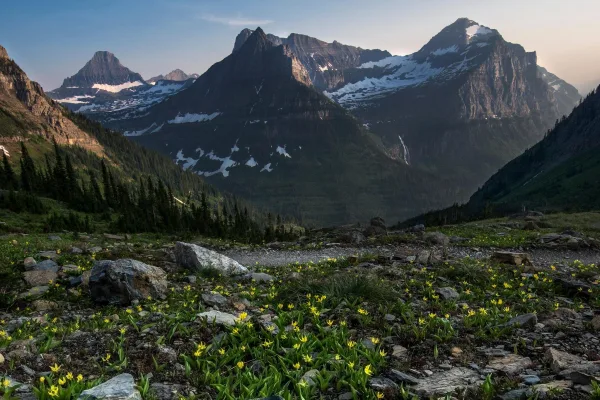
Glacier National Park
National Park
A showcase of melting glaciers, alpine meadows, carved valleys, and spectacular lakes. With over 700 miles of trails, Glacier is a paradise for adventurous visitors seeking a landscape steeped in huma...
18 mi from route
~45 min detour
$35
near mile 44.6
Park Closure: Going-to-the-Sun Road Seasonal Closure
Park data from the National Park Service API. Alerts update every 2 hours.
Fuel & Cost
Regular Gas
$102.59 one way
$205.18 round trip
$4.03/gal25.4 MPG avg227 kg CO2
Fuel Type
$/gal
One Way
Round Trip
midgrade
$4.22
$107.53
$215.07
premium
$4.53
$115.49
$230.97
diesel
$5.61
$142.94
$285.88
No toll roads detected on this route.
Estimated Trip Cost (one way, 1 person)
Fuel
$103
Hotel (1n)
$80–$140
Meals
$50–$100
Total
$233–$343
Rough estimate based on US averages. Hotel $80–$140/night, meals $25–$50/day.
Estimated CO2 emission: 226.5 kg one way.
Prices: EIA weekly data, 2026-04-13.
Driving Electric?
About $68 in charging
· 2 stops
· 67% less CO2
Vehicle Type
kWh
Stops
DC Fast
Home Charge
Average EV
194.2
2
$67.98
$31.08
Efficient EV
161.9
1
$56.65
$25.90
EV Truck/SUV
259
3
$90.64
$41.43
Gas CO2
227 kg
EV CO2
76 kg (67% less)
Plan for 2 charging stops, roughly every 270 miles. Allow 25-40 minutes per stop at a DC fast charger.
DC fast charging avg $0.35/kWh. Home charging avg $0.16/kWh. US grid CO2: 0.39 kg/kWh.
Travel Intel
Current conditions at both ends of the drive.
Forecast as of Apr 15, 2026
Origin
Kalispell, MT
Morning
in Kalispell on Saturday
Local time
9:55 AM
MDT
Current temp
60°F
Unavailable
Live forecast
Destination
Baker, MT
Morning
in Baker on Saturday
Local time
9:55 AM
MDT
Current temp
72°F
Unavailable
Live forecast
65°F
Lewistown, MT
427 mi in
Seasonal Notes
Summer travel usually means heavier construction, hotter rest stops, and busier weekend traffic around major cities.
Winter travel shortens daylight, so a route that looks manageable on paper can feel much longer after dark.
Holiday weekends tend to make both departure and arrival windows slower than the raw route time suggests.
For long drives, weather on day two can matter just as much as conditions at departure, so check the whole travel window rather than only the first day.
Time zone
Same local time
Origin and destination are on the same clock, so arrival timing is easier to judge at a glance.
Temperature spread
12 degrees warmer at arrival
A meaningful temperature swing is a good cue to rethink layers, water, and how soon you want to arrive.
Road read
12h 20m on the road
This is long enough that the arrival forecast matters almost as much as departure conditions. Recheck both ends before you roll.
Weather data from the National Weather Service. Conditions may change; check closer to your travel date.
Frequently Asked Questions
The drive from Kalispell, MT to Baker, MT covers 647.4 miles and takes about 12h 20m without stops. Add 15-30 minutes for a fuel or rest stop on longer drives.
The main roads are US Highway 87, US Route 2, US 87. Expect a mix of highway and local road driving.
Consider an overnight stop or starting very early.
Yes. This route is usually more comfortable as a 2-day drive. A sensible stopping point is after roughly 324 miles on day one.
The midpoint is about 323.7 miles from Kalispell, MT. Look for rest areas, gas stations, or food options near the halfway mark.
At current regular gas prices, expect to spend about $102.59 one way. This estimate uses 25.4 MPG — your actual cost will vary with your vehicle's fuel efficiency and current gas prices.
Start early — leave by 6-7 AM to arrive at a reasonable hour. This is a long drive — plan for a morning departure or consider splitting it into two days.
Plan about 3 meaningful breaks for fuel, food, or rest. Plan on a short reset every 3 to 4 hours to stay fresh behind the wheel.
This drive requires moderate attention. Across 647.4 miles you will encounter 25 spots where lane choice or exit timing matters. Not difficult for experienced highway drivers, but worth previewing the tricky sections before you go.
The main spots that need attention: at 0.2 miles (3rd Avenue East): Navigation decision point; at 0.3 miles (2nd Street East): Navigation decision point; at 8.1 miles (MT 206): Lane positioning matters here.
The route from Kalispell, MT to Baker, MT does not surface many named destination signs beyond the main corridor.
Yes. Nearby national parks include Glacier National Park.
How this page is built
Compiled by the Trip.ovh planning team at COD Solutions Oy from open government datasets — OSRM over OpenStreetMap for geometry, EIA for fuel prices, and NPS for national parks. See our methodology for refresh cadence and limitations.