This 250.6-mile journey from Kelso, WA to Pasco, WA will take approximately 4 hours and 53 minutes of driving time. It's a manageable one-day trip, allowing you to complete the drive without needing an overnight stay. You'll primarily be on US 12 and I-82, with a brief stint on I-5. The estimated fuel cost for this route is around $52. This highway-focused drive is a practical way to traverse the state of Washington, moving from one side to the other efficiently. Given its direct nature, it's a straightforward transit rather than a leisurely exploration.
Trip Pace
Same-day drive is realistic
A same-day return is possible, but it will make for a full day on the road.
Break Rhythm
1 planned break
Plan on a short reset every 3 to 4 hours to stay fresh behind the wheel.
Midpoint
125.3 miles from Kelso, WA
A natural place for your longest stop of the day
, about 2h 28m into the drive
.
Who Is This Route For?
Weekend Trip
Doable as a same-day drive at 4h 53m. Total distance: 250.6 miles.
Family Friendly
Moderate complexity with 1 natural rest stops along the way.
Expect a predominantly highway-focused experience on this route, with 99% of the drive being on major roads like US 12 and I-82. The longest uninterrupted stretch you'll encounter is 156.6 miles, primarily on US 12, meaning you can settle in for a solid period of driving. While it's a highway drive, US 12 offers a different feel than a pure interstate, potentially providing more varied scenery as you transition across Washington. The route is designed for efficient travel, so don't anticipate many winding backroads.
Most of the miles stay on highways, which makes pacing and fuel planning easier than turn-by-turn city driving.
There are about 16 navigation steps in the underlying route data, so the final approach matters more than the middle miles.
US 12 is the longest continuous segment at about 156.6 miles.
How Hard Is This Drive?
This is a straightforward highway drive that stays mostly on US 12 and I 82. There are only a few real navigation decisions along the way. The trickiest moment comes early in the drive near WA 4 / Cowlitz Way.
Driving Effort4/10
Easy - simple navigation with a manageable amount of wheel time
Balances navigation complexity with total wheel time.
This is a straightforward 4h 53m drive. You will face about 11 decision points, but nothing that requires special attention if you follow navigation.
Where does it get tricky?
The main spots that need attention: near the start (WA 4 / Cowlitz Way): Navigation decision point; at 0.1 miles (North Pacific Avenue): Navigation decision point; at 28.4 miles: Exit ramp - move to the correct lane early. Multiple destination signs - pick the right one.
Critical Maneuvers
5 of 11 key points
These are the spots where you need to pay the most attention. Preview them before you drive.
5
0 mi into trip|~0m in|WA 4 / Cowlitz Way
Turn right onto WA 4 / Cowlitz Way
Navigation decision point
5
0.1 mi into trip|~0m in|North Pacific Avenue
Turn right onto North Pacific Avenue
Navigation decision point
5
28.4 mi into trip|~32m in
Take the exit toward US 12 East: Morton, Yakima
Exit ramp - move to the correct lane early. Multiple destination signs - pick the right one
Toward US 12 East: Morton, Yakima
8
235 mi into trip|~4h 34m in|US 12
Take the exit onto US 12 toward I‑182 east, US 12 east: Richland, Pasco
Exit ramp - move to the correct lane early. Lane positioning matters here. Multiple destination signs - pick the right one
Use the straight / slight right lanes.
Exit 102
Toward I‑182 east, US 12 east: Richland, Pasco
7
249.4 mi into trip|~4h 50m in
Take the exit toward North 4th Avenue: Pasco City Center
Exit ramp - move to the correct lane early. Lane positioning matters here
Use the straight / slight right lanes.
Exit 13
Toward North 4th Avenue: Pasco City Center
Towns Mentioned on Route Signs
Based on OSRM destination-sign hints, not a full list of every settlement the road passes.
Between Kelso, WA and Pasco, WA, road signs point toward Yakima and I‑182 East.
Yakima
28.4 mi in|~32m
I‑182 East
235 mi in|~4h 34m|via US 12
Main Roads
Road
Distance
Duration
US 12
156.6 mi
3h 8m
I 82
64.1 mi
1h 8m
I 5
27.1 mi
29m
North Kelso Avenue
0.7 mi
1m
North 4th Avenue
0.6 mi
1m
Court Street
0.3 mi
<1m
North Pacific Avenue
0.2 mi
<1m
North 8th Avenue
0.1 mi
<1m
Longest stretch:
US 12
— 156.6 mi, about 3h 8m
Turn-by-Turn Driving Directions
Step-by-step road directions between Kelso, WA and Pasco, WA.
1
Start on North 4th Avenue
32 ft·5 sec·North 4th Avenue
2
Turn right onto WA 4
0.1 mi·13 sec·Cowlitz Way
3
Turn right onto North Pacific Avenue
0.2 mi·24 sec·North Pacific Avenue
4
Continue on North Kelso Avenue
0.7 mi·1 min·North Kelso Avenue
5
Take the ramp
0.3 mi·36 sec
6
Merge onto I 5
27 mi·29 min·I 5
7
Take the exit
0.3 mi·40 sec
Toward US 12 East: Morton, Yakima
8
Turn right onto US 12
119 mi·2 hr 22 min·US 12
9
Continue on US 12
23 mi·30 min·US 12
10
Keep slight left at fork onto I 82; US 12
64 mi·1 hr 8 min·I 82; US 12
11
Take the exit onto US 12
14 mi·15 min·US 12
Exit 102Toward I‑182 east, US 12 east: Richland, PascoUse the straight / slight right lanes.
12
Take the exit
0.2 mi·24 sec
Exit 13Toward North 4th Avenue: Pasco City CenterUse the straight / slight right lanes.
13
Turn straight onto North 4th Avenue
0.6 mi·1 min·North 4th Avenue
14
Turn right onto Court Street
0.3 mi·42 sec·Court Street
15
Turn left onto North 8th Avenue
0.1 mi·28 sec·North 8th Avenue
16
Arrive at destination
North 8th Avenue
Trip Plan
For this 4-hour, 53-minute drive, consider an early morning departure from Kelso to make the most of your day. With only one recommended stop, you have flexibility in pacing yourself. Keep an eye on your fuel levels, especially during the 156.6-mile stretch on US 12, as services can be less frequent on certain highway segments. The estimated fuel cost of $52 is a good budget point to keep in mind. Since this is a single-day trip, you can easily adjust your schedule on the fly.
Morning Departure
An early start around 7-8 AM gets you there with plenty of daylight left.
Evening Departure
A late afternoon start means arriving after dark. Morning is better.
You can normally do this drive in one day.
Plan roughly 1 meaningful break for fuel, food, and rest.
The halfway point lands around 125.3 miles from Kelso, WA, or about 2h 28m into the drive.
The longest continuous stretch on this route runs about 156.6 miles.
This is a comfortable same-day trip.
Departure
Before you leave
Start with fuel, water, and navigation already sorted so the first hour feels easy.
First stop
Around 55 miles or 1h 4m in
Use this first pause for coffee, a restroom break, and a quick traffic check ahead.
Halfway reset
Around 125.3 miles or 2h 28m in
This is the best place for your longest stop, a real meal, and a full fuel check.
Final approach
Final hour starts around 4h 3m
Traffic, exits, and arrival timing usually matter more near Pasco, WA than in the middle of the route.
Before You Leave
+
Open the route before leaving Kelso, WA so your first major turns are already loaded.
+
Leave with enough water and a charging cable within reach, not packed away.
+
Check your fuel range against the first long segment, especially if you are starting outside city service areas.
Day 1
Settle into the route from Kelso, WA
This is one driving day of about 250.6 miles and 4h 53m.
Your first comfortable stop window is around 55 miles from Kelso, WA.
This route can stay practical as a one-day drive if traffic stays reasonable.
Plan about 1 real break rather than only quick fuel stops.
The longest stretch is on US 12 for about 156.6 miles.
Where to Stop
Rest stops, refuel points, and overnight suggestions along this route.
Halfway Point
Midpoint
About 125.3 mi from Kelso, WA
· 2h 28m into the drive
The midpoint is around 125.3 miles from Kelso, WA, which is a good place for a longer meal and fuel stop.
Before the longest stretch
Fuel check
Top up before US 12 if your tank is already low. That segment runs about 156.6 miles.
Arriving in Pasco, WA
The final approach into Pasco, WA usually feels slower than the middle of the drive, so avoid planning your tightest schedule at the very end.
Try to arrive with enough fuel left to skip an immediate station stop unless you already know the area around Pasco, WA.
After long uninterrupted mileage, take five minutes before the last urban segment to reset and refocus on exits, merges, and city traffic.
These stop ideas are pacing suggestions — the exact town or exit can change with traffic, hotel plans, and fuel range.
National Parks Near This Route
Worth a detour if your schedule allows.
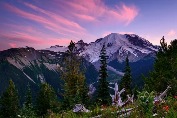
Mount Rainier National Park
National Park
Ascending to 14,410 feet above sea level, Mount Rainier stands as an icon in the Washington landscape. An active volcano, Mount Rainier is the most glaciated peak in the contiguous U.S.A., spawning fi...
15 mi from route
~37 min detour
$30
near mile 103.7
Park Closure: Paradise Road Status: Gate closed at Longmire, projected to open tomorrow
Park Closure: SR 165 Carbon River/Fairfax Bridge is closed: no access to Carbon River or Mowich Lake.
Park data from the National Park Service API. Alerts update every 2 hours.
Fuel & Cost
Regular Gas
$52.45 one way
$104.90 round trip
$5.32/gal25.4 MPG avg88 kg CO2
Fuel Type
$/gal
One Way
Round Trip
midgrade
$5.58
$55.00
$110.01
premium
$5.77
$56.91
$113.82
diesel
$5.61
$55.33
$110.66
No toll roads detected on this route.
Estimated Trip Cost (one way, 1 person)
Fuel
$52
Meals
$25–$50
Total
$77–$102
Rough estimate based on US averages. Hotel $80–$140/night, meals $25–$50/day.
Estimated CO2 emission: 87.7 kg one way.
Prices: EIA weekly data, 2026-04-13.
EV Charging Along Route
4 DC fast chargers
· Coverage: good
ChargePoint Charging Station
Wapato, Washington
ChargePoint
1 DCFC
ChargePoint Charging Station
Packwood, Washington
ChargePoint
1 DCFC
ChargePoint Charging Station
Yakima, Washington
ChargePoint
1 DCFC
Chevrolet Charging Station
Yakima, Washington
Other
1 DCFC
ChargePoint: 3
Other: 1
Station data from NREL Alternative Fuel Stations database.
Driving Electric?
About $26 in charging
· 0 stops
· 67% less CO2
Vehicle Type
kWh
Stops
DC Fast
Home Charge
Average EV
75.2
0
$26.31
$12.03
Efficient EV
62.7
0
$21.93
$10.02
EV Truck/SUV
100.2
1
$35.08
$16.04
Gas CO2
88 kg
EV CO2
29 kg (67% less)
Plan for 0 charging stops, roughly every 270 miles. Allow 25-40 minutes per stop at a DC fast charger.
DC fast charging avg $0.35/kWh. Home charging avg $0.16/kWh. US grid CO2: 0.39 kg/kWh.
Travel Intel
Current conditions at both ends of the drive.
Forecast as of Apr 15, 2026
Origin
Kelso, WA
Late night
in Kelso on Friday
Local time
12:47 AM
PDT
Current temp
60°F
Unavailable
Live forecast
Destination
Pasco, WA
Late night
in Pasco on Friday
Local time
12:47 AM
PDT
Current temp
67°F
Unavailable
Live forecast
Seasonal Notes
Summer travel usually means heavier construction, hotter rest stops, and busier weekend traffic around major cities.
Winter travel shortens daylight, so a route that looks manageable on paper can feel much longer after dark.
Holiday weekends tend to make both departure and arrival windows slower than the raw route time suggests.
Time zone
Same local time
Origin and destination are on the same clock, so arrival timing is easier to judge at a glance.
Temperature spread
7 degrees warmer at arrival
A meaningful temperature swing is a good cue to rethink layers, water, and how soon you want to arrive.
Road read
4h 53m on the road
An early start around 7-8 AM gets you there with plenty of daylight left.
Weather data from the National Weather Service. Conditions may change; check closer to your travel date.
Frequently Asked Questions
The drive from Kelso, WA to Pasco, WA covers 250.6 miles and takes about 4h 53m without stops. Add 15-30 minutes for a fuel or rest stop on longer drives.
The main roads are US 12, I 82, I 5. Most of the drive stays on highways, so watch for ramps and exits.
This is a comfortable same-day trip.
The midpoint is about 125.3 miles from Kelso, WA. Look for rest areas, gas stations, or food options near the halfway mark.
At current regular gas prices, expect to spend about $52.45 one way. This estimate uses 25.4 MPG — your actual cost will vary with your vehicle's fuel efficiency and current gas prices.
An early start around 7-8 AM gets you there with plenty of daylight left. A late afternoon start means arriving after dark. Morning is better.
Plan about 1 meaningful break for fuel, food, or rest. Plan on a short reset every 3 to 4 hours to stay fresh behind the wheel.
This is a straightforward 4h 53m drive. You will face about 11 decision points, but nothing that requires special attention if you follow navigation.
The main spots that need attention: near the start (WA 4 / Cowlitz Way): Navigation decision point; at 0.1 miles (North Pacific Avenue): Navigation decision point; at 28.4 miles: Exit ramp - move to the correct lane early. Multiple destination signs - pick the right one.
Between Kelso, WA and Pasco, WA, road signs point toward Yakima and I‑182 East.
Data sources
The figures on this page are computed from open government and mapping datasets, not crowdsourced reviews. Distances and geometry come from
OSRM
over
OpenStreetMap.
Fuel cost uses
EIA
weekly regional averages.
EV charging comes from the
NREL Alternative Fuels
dataset.
National park proximity is from the
NPS API.
Full methodology, refresh cadence, and limitations are documented on the
methodology page.