Trip from Kill Devil Hills, NC to Raleigh, NC

Drive Time

4h 9m

Distance

202.2 mi

325 km

Drive Score

8/10

Great drive

Same Day?

Yes, doable

Fuel Cost

$32

one way

EV Charging

None

0 DC fast

Best Time to Leave

Save up to 39 min
4 AM
3h 56m ★
6 AM
4h 9m
8 AM
4h 35m
10 AM
4h 18m
12 PM
4h 16m
3 PM
4h 20m
5 PM
4h 34m
8 PM
4h 1m

Estimated drive times based on typical traffic patterns. Actual times may vary with weather, construction, and real-time conditions.

Downtown Kill Devil Hills, NC, NC

Kill Devil Hills, NC

William Lucord

Downtown Raleigh, NC, NC

Raleigh, NC

Evgeniia Belman

Trip Overview

The drive from Kill Devil Hills, NC to Raleigh, NC covers 202.2 miles and takes about 4h 9m behind the wheel. This route is realistic as a one-day drive if you keep your stops efficient.

The route leans on US 64, US 13, US 64 Bypass for much of the mileage, and the overall profile is highway-focused drive. The longest uninterrupted segment is about 67.3 miles on US 64. At current regular gas prices, budget about $32.36 one way before food or hotel costs.

Trip Pace

Same-day drive is realistic

A same-day return is possible, but it will make for a full day on the road.

Break Rhythm

1 planned break

Plan on a short reset every 3 to 4 hours to stay fresh behind the wheel.

Midpoint

101.1 miles from Kill Devil Hills, NC

A natural place for your longest stop of the day , about 2h 16m into the drive .

Drive Character

This is a 4h 9m highway drive covering 202.2 miles, with most of the trip on US 64 and US 13. The longest continuous stretch is about 67.3 miles on US 64.

Most of the miles stay on highways, which makes pacing and fuel planning easier than turn-by-turn city driving.
There are about 18 navigation steps in the underlying route data, so the final approach matters more than the middle miles.
US 64 is the longest continuous segment at about 67.3 miles.

How Hard Is This Drive?

This is a straightforward highway drive that stays mostly on US 64 and US 13. You will hit about 10 points where you need to pay attention to lane position or signs. The trickiest moment comes around 0.1 miles in near West 3rd Street.

Route Complexity 5/10

Moderate - straightforward overall, but long enough or busy enough to require pacing

This drive requires moderate attention. Across 202.2 miles you will encounter 10 spots where lane choice or exit timing matters. Not difficult for experienced highway drivers, but worth previewing the tricky sections before you go.

Where does it get tricky?

The main spots that need attention: at 0.1 miles (West 3rd Street): Navigation decision point; at 32.3 miles (US 64): Highway fork - watch signs carefully. Lane positioning matters here; at 199.8 miles: Exit ramp - move to the correct lane early. Lane positioning matters here.

Critical Maneuvers

5 of 10 key points

These are the spots where you need to pay the most attention. Preview them before you drive.

5
0.1 mi into trip | ~0m in | West 3rd Street

Turn right onto West 3rd Street

Navigation decision point

6
32.3 mi into trip | ~47m in | US 64

Keep slight left at fork onto US 64

Highway fork - watch signs carefully. Lane positioning matters here

Use the straight lane.
6
199.8 mi into trip | ~4h 3m in

Take the exit toward Rock Quarry Rd North

Exit ramp - move to the correct lane early. Lane positioning matters here

Use the straight / slight right lanes. Toward Rock Quarry Rd North
5
200.8 mi into trip | ~4h 5m in | Martin Luther King Jr Boulevard

Turn left onto Martin Luther King Jr Boulevard

Lane positioning matters here

Use the straight / right lanes.
6
202 mi into trip | ~4h 8m in | South Wilmington Street

Turn right onto South Wilmington Street

Lane positioning matters here

Use the straight / right lanes.

Main Roads

Road Distance Duration
US 64 67.3 mi 1h 27m
US 13 58.3 mi 1h 3m
US 64 Bypass 38.9 mi 41m
Washington Baum Bridge 20.7 mi 27m
North Croatan Highway 9.8 mi 16m
I 87 2.7 mi 3m
South Virginia Dare Trail 1.4 mi 2m
Martin Luther King Jr Boulevard 1.2 mi 2m
Longest stretch: US 64 — 67.3 mi, about 1h 27m

Turn-by-Turn Driving Directions

Step-by-step road directions between Kill Devil Hills, NC and Raleigh, NC.

1

Start on Creek Street

0.1 mi · 30 sec · Creek Street
2

Turn right onto West 3rd Street

0.2 mi · 37 sec · West 3rd Street
3

Turn right onto US 158

9.8 mi · 16 min · North Croatan Highway
4

Continue on US 64

1.4 mi · 2 min · South Virginia Dare Trail
5

Continue on US 64

21 mi · 27 min · Washington Baum Bridge
6

Keep slight left at fork onto US 64

67 mi · 1 hr 27 min · US 64
Use the straight lane.
7

Turn left onto US 13; US 17

1.8 mi · 2 min · US 13; US 17
8

Continue on US 13; US 64

57 mi · 1 hr 1 min · US 13; US 64
9

Continue on US 64 Bypass

39 mi · 41 min · US 64 Bypass
Use the straight / slight right lanes.
10

Merge onto I 87; I 440; US 64

2.7 mi · 3 min · I 87; I 440; US 64
11

Merge onto I 40; US 64

0.4 mi · 29 sec · Thomas Bradshaw Freeway
12

Take the exit

0.3 mi · 37 sec
Toward Rock Quarry Rd North Use the straight / slight right lanes.
13

Turn straight onto Rock Quarry Road

0.4 mi · 49 sec · Rock Quarry Road
14

Turn left onto Rock Quarry Road

0.3 mi · 41 sec · Rock Quarry Road
15

Turn left onto Martin Luther King Jr Boulevard

1.2 mi · 2 min · Martin Luther King Jr Boulevard
Use the straight / right lanes.
16

Turn right onto South Wilmington Street

0.2 mi · 41 sec · South Wilmington Street
Use the straight / right lanes.
17

Turn left onto East South Street

24 ft · 0 sec · East South Street
18

Arrive at destination

East South Street

Trip Plan

Morning Departure

An early start around 7-8 AM gets you there with plenty of daylight left.

Evening Departure

A late afternoon start means arriving after dark. Morning is better.

You can normally do this drive in one day.
Plan roughly 1 meaningful break for fuel, food, and rest.
The halfway point lands around 101.1 miles from Kill Devil Hills, NC, or about 2h 16m into the drive.
The longest continuous stretch on this route runs about 67.3 miles.

This is a comfortable same-day trip.

Departure

Before you leave

Start with fuel, water, and navigation already sorted so the first hour feels easy.

First stop

Around 80 miles or 1h 49m in

Use this first pause for coffee, a restroom break, and a quick traffic check ahead.

Halfway reset

Around 101.1 miles or 2h 16m in

This is the best place for your longest stop, a real meal, and a full fuel check.

Final approach

Final hour starts around 3h 26m

Traffic, exits, and arrival timing usually matter more near Raleigh, NC than in the middle of the route.

Before You Leave

+

Open the route before leaving Kill Devil Hills, NC so your first major turns are already loaded.

+

Leave with enough water and a charging cable within reach, not packed away.

+

Check your fuel range against the first long segment, especially if you are starting outside city service areas.

Day 1

Settle into the route from Kill Devil Hills, NC

This is one driving day of about 202.2 miles and 4h 9m.

Your first comfortable stop window is around 80 miles from Kill Devil Hills, NC.
This route can stay practical as a one-day drive if traffic stays reasonable.
Plan about 1 real break rather than only quick fuel stops.
The longest stretch is on US 64 for about 67.3 miles.

Where to Stop

Rest stops, refuel points, and overnight suggestions along this route.

Halfway Point

Midpoint

About 101.1 mi from Kill Devil Hills, NC · 2h 16m into the drive

Downtown Greenville, NC, NC

Mid-route town

Meal stop

Greenville, NC

101 mi into the route

Best for: Lunch, fuel, and a longer reset

This sits close to the middle of the route, so it works well for the longest stop of the day.

Popular next leg

Greenville, NC to Raleigh, NC

85.4 mi · 1h 20m

Pacing Suggestions

Greenville, NC

Fuel and coffee

A short stop after about 80 miles helps settle the day before fatigue starts building.

Greenville, NC

Meal break

The midpoint is around 101.1 miles from Kill Devil Hills, NC, which is a good place for a longer meal and fuel stop.

Before the longest stretch

Fuel check

Top up before US 64 if your tank is already low. That segment runs about 67.3 miles.

Arriving in Raleigh, NC

The final approach into Raleigh, NC usually feels slower than the middle of the drive, so avoid planning your tightest schedule at the very end.

Try to arrive with enough fuel left to skip an immediate station stop unless you already know the area around Raleigh, NC.

These stop ideas are pacing suggestions — the exact town or exit can change with traffic, hotel plans, and fuel range.

National Parks Near This Route

Worth a detour if your schedule allows.

Wright Brothers National Memorial

Wright Brothers National Memorial

National Memorial

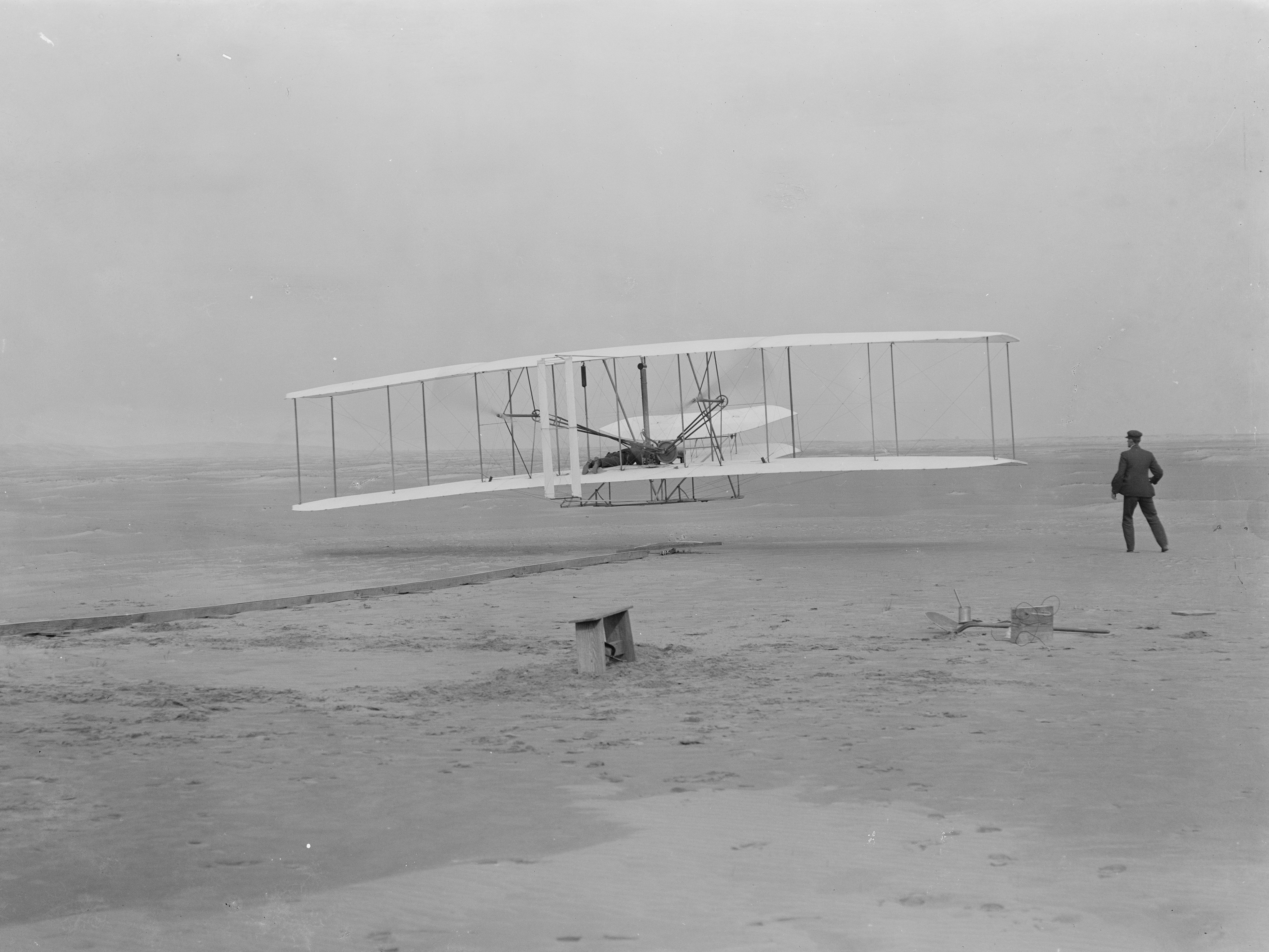
Wind, sand, and a dream of flight brought Wilbur and Orville Wright to Kitty Hawk, North Carolina where, after four years of scientific experimentation, they achieved the first successful airplane fli...

1 mi from route ~3 min detour $10
View on nps.gov

Park data from the National Park Service API. Alerts update every 2 hours.

Fuel & Cost

Regular Gas

$32.36 one way

$64.72 round trip

$4.07/gal 25.4 MPG avg 71 kg CO2
Fuel Type $/gal One Way Round Trip
midgrade $4.43 $35.26 $70.52
premium $4.78 $38.04 $76.07
diesel $5.64 $44.92 $89.84

No toll roads detected on this route.

Estimated Trip Cost (one way, 1 person)

Fuel

$32

Meals

$25–$50

Total

$57–$82

Rough estimate based on US averages. Hotel $80–$140/night, meals $25–$50/day.

Estimated CO2 emission: 70.7 kg one way. Prices: EIA weekly data, 2026-04-06.

Driving Electric?

About $21 in charging · 0 stops · 66% less CO2

Vehicle Type kWh Stops DC Fast Home Charge
Average EV 60.7 0 $21.23 $9.71
Efficient EV 50.6 0 $17.69 $8.09
EV Truck/SUV 80.9 1 $28.31 $12.94

Gas CO2

71 kg

EV CO2

24 kg (66% less)

This trip is well within single-charge range for most EVs. No charging stops needed if you start fully charged.

DC fast charging avg $0.35/kWh. Home charging avg $0.16/kWh. US grid CO2: 0.39 kg/kWh.

Travel Intel

Current conditions at both ends of the drive.

Forecast data refreshed 20 hours ago

Origin

Kill Devil Hills, NC

Morning in Kill Devil Hills on Monday

Local time

10:49 AM

EDT

Current temp

62°F

Unavailable

Live forecast

Destination

Raleigh, NC

Morning in Raleigh on Monday

Local time

10:49 AM

EDT

Current temp

66°F

Unavailable

Live forecast

Seasonal Notes

Summer travel usually means heavier construction, hotter rest stops, and busier weekend traffic around major cities.

Winter travel shortens daylight, so a route that looks manageable on paper can feel much longer after dark.

Holiday weekends tend to make both departure and arrival windows slower than the raw route time suggests.

Time zone

Same local time

Origin and destination are on the same clock, so arrival timing is easier to judge at a glance.

Temperature spread

4 degrees warmer at arrival

A meaningful temperature swing is a good cue to rethink layers, water, and how soon you want to arrive.

Road read

4h 9m on the road

An early start around 7-8 AM gets you there with plenty of daylight left.

Weather data from the National Weather Service. Conditions may change; check closer to your travel date.

Frequently Asked Questions

The drive from Kill Devil Hills, NC to Raleigh, NC covers 202.2 miles and takes about 4h 9m without stops. Add 15-30 minutes for a fuel or rest stop on longer drives.
The main roads are US 64, US 13, US 64 Bypass. Most of the drive stays on highways, so watch for ramps and exits.
This is a comfortable same-day trip.
The midpoint is about 101.1 miles from Kill Devil Hills, NC. Look for rest areas, gas stations, or food options near the halfway mark.
At current regular gas prices, expect to spend about $32.36 one way. This estimate uses 25.4 MPG — your actual cost will vary with your vehicle's fuel efficiency and current gas prices.
An early start around 7-8 AM gets you there with plenty of daylight left. A late afternoon start means arriving after dark. Morning is better.
Plan about 1 meaningful break for fuel, food, or rest. Plan on a short reset every 3 to 4 hours to stay fresh behind the wheel.
This drive requires moderate attention. Across 202.2 miles you will encounter 10 spots where lane choice or exit timing matters. Not difficult for experienced highway drivers, but worth previewing the tricky sections before you go.
The main spots that need attention: at 0.1 miles (West 3rd Street): Navigation decision point; at 32.3 miles (US 64): Highway fork - watch signs carefully. Lane positioning matters here; at 199.8 miles: Exit ramp - move to the correct lane early. Lane positioning matters here.
The route from Kill Devil Hills, NC to Raleigh, NC does not surface many named destination signs beyond the main corridor.

Was this route helpful?

Thanks for your feedback!

Your tip has been submitted. Thanks!

/500

Explore More

Explore more options from Kill Devil Hills, NC or browse trips ending in Raleigh, NC.

Looking for more statewide routes? Browse NC road trips.

Explore maps for Kill Devil Hills, NC or Raleigh, NC on MapSof.net.