
Trip from Makawao, HI to Kēōkea, HI

Data updated 5 hours ago

Drive Time

21m

Distance

11.6 mi

19 km

Drive Score

5/10

Practical drive

Same Day?

Yes, doable

Fuel Cost

$3

one way

EV Charging

Excellent

2 DC fast

Best Time to Leave

Save up to 6 min
4 AM
0h 19m ★
6 AM
0h 21m
8 AM
0h 25m
10 AM
0h 22m
12 PM
0h 22m
3 PM
0h 23m
5 PM
0h 25m
8 PM
0h 20m

Estimated drive times based on typical traffic patterns. Actual times may vary with weather, construction, and real-time conditions.

human settlement in Maui County, Hawaii, United States of America

Makawao, HI

Wikimedia Commons

Trip Overview

This 11.6-mile drive from Makawao to Kēōkea in Hawaii is easily manageable in about 21 minutes, making it a perfect day trip. You'll primarily navigate via Kula Highway, Makawao Avenue, and Baldwin Avenue, with no highway driving involved. Budget around $3 for fuel for this short journey. The overall feel is that of a local, turn-heavy drive, offering a glimpse into the region's character. Since it's such a brief distance, you'll have plenty of flexibility to explore at your own pace.

Trip Pace

Same-day drive is realistic

A same-day return is realistic if you keep stops short.

Break Rhythm

0 planned breaks

A short stop every 2 to 3 hours is enough for this drive.

Midpoint

5.8 miles from Makawao, HI

A natural place for your longest stop of the day , about 10m into the drive .

Loading map...

Drive Character

Expect a turn-heavy local drive on this route, with the longest uninterrupted stretch being 9.6 miles along Kula Highway. With a 0% highway share, this journey keeps you on local roads for its entirety. The road conditions will likely vary as you transition between Makawao Avenue, Baldwin Avenue, and Kula Highway, offering a dynamic driving experience. You won't encounter any monotonous highway stretches, ensuring your attention remains engaged throughout the approximately 21-minute trip.

This route has more turning and local-road decision points than a simple highway run.
There are about 5 navigation steps in the underlying route data, so the final approach matters more than the middle miles.
Kula Highway is the longest continuous segment at about 9.6 miles.

How Hard Is This Drive?

Expect a hands-on drive with frequent turns and local roads rather than long highway stretches. Navigation is very simple — set it and forget it for most of the drive. The trickiest moment comes early in the drive near HI 390 / Baldwin Avenue.

Route Complexity 2/10

Very easy - short and simple to drive

The drive from Makawao, HI to Kēōkea, HI is easy. At 21m with 0% highway, most drivers will find it relaxed and low-stress.

Where does it get tricky?

The main spots that need attention: near the start (HI 390 / Baldwin Avenue): Navigation decision point; at 0.3 miles (HI 365 / Makawao Avenue): Navigation decision point; at 2 miles (HI 37 / Kula Highway): Lane positioning matters here.

Critical Maneuvers

3 of 3 key points

These are the spots where you need to pay the most attention. Preview them before you drive.

5
0 mi into trip | ~0m in | HI 390 / Baldwin Avenue

Turn right onto HI 390 / Baldwin Avenue

Navigation decision point

3
0.3 mi into trip | ~0m in | HI 365 / Makawao Avenue

Turn right onto HI 365 / Makawao Avenue

Navigation decision point

5
2 mi into trip | ~3m in | HI 37 / Kula Highway

Turn left onto HI 37 / Kula Highway

Lane positioning matters here

Use the left lane.

Main Roads

Road Distance Duration
Kula Highway 9.6 mi 17m
Makawao Avenue 1.8 mi 3m
Baldwin Avenue 0.2 mi <1m
Ukiu Road <0.1 mi <1m
Longest stretch: Kula Highway — 9.6 mi, about 17m

Turn-by-Turn Driving Directions

Step-by-step road directions between Makawao, HI and Kēōkea, HI.

1

Start on Ukiu Road

155 ft · 9 sec · Ukiu Road
2

Turn right onto HI 390

0.2 mi · 29 sec · Baldwin Avenue
3

Turn right onto HI 365

1.8 mi · 3 min · Makawao Avenue
4

Turn left onto HI 37

9.6 mi · 17 min · Kula Highway
Use the left lane.
5

Arrive at destination

HI 37

Trip Plan

Given the short 11.6-mile distance and 21-minute estimated travel time, this trip offers maximum flexibility. You can depart anytime, but an early morning start might offer cooler temperatures and less traffic. With a minimal fuel cost of $3, refueling isn't a major concern, but it's always wise to start with a full tank. Since there are no designated stops mentioned, plan to pull over if you see a point of interest that catches your eye. A specific tip for this route: pay close attention to the frequent turns, especially as you transition onto Kula Highway for its longest stretch.

Morning Departure

Leave by 9 AM and you'll arrive before lunch.

Evening Departure

Even a 4 PM departure gets you there before dark in summer.

You can normally do this drive in one day.
You may only need one short stretch break if traffic stays light.
The halfway point lands around 5.8 miles from Makawao, HI, or about 10m into the drive.
The longest continuous stretch on this route runs about 9.6 miles.

This is a comfortable same-day trip.

Departure

Before you leave

Start with fuel, water, and navigation already sorted so the first hour feels easy.

First stop

Around 11.6 miles or 21m in

Use this first pause for coffee, a restroom break, and a quick traffic check ahead.

Halfway reset

Around 5.8 miles or 10m in

This is the best place for your longest stop, a real meal, and a full fuel check.

Final approach

Final hour starts around 18m

Traffic, exits, and arrival timing usually matter more near Kēōkea, HI than in the middle of the route.

Before You Leave

+

Open the route before leaving Makawao, HI so your first major turns are already loaded.

+

Leave with enough water and a charging cable within reach, not packed away.

+

Check your fuel range against the first long segment, especially if you are starting outside city service areas.

Day 1

Settle into the route from Makawao, HI

This is one driving day of about 11.6 miles and 21m.

Your first comfortable stop window is around 80 miles from Makawao, HI.
This route can stay practical as a one-day drive if traffic stays reasonable.
You may only need one short stretch stop if conditions stay smooth.
The longest stretch is on Kula Highway for about 9.6 miles.

Where to Stop

Rest stops, refuel points, and overnight suggestions along this route.

Halfway Point

Midpoint

About 5.8 mi from Makawao, HI · 10m into the drive

census-designated place in Maui County, Hawaii, United States of America

Mid-route town

Meal stop

Wailea, HI

6 mi into the route

Best for: Lunch, fuel, and a longer reset

This sits close to the middle of the route, so it works well for the longest stop of the day.

Pacing Suggestions

Wailea, HI

Fuel and coffee

A short stop after about 11.6 miles helps settle the day before fatigue starts building.

Wailea, HI

Meal break

The midpoint is around 5.8 miles from Makawao, HI, which is a good place for a longer meal and fuel stop.

Arriving in Kēōkea, HI

The final approach into Kēōkea, HI usually feels slower than the middle of the drive, so avoid planning your tightest schedule at the very end.

Try to arrive with enough fuel left to skip an immediate station stop unless you already know the area around Kēōkea, HI.

These stop ideas are pacing suggestions — the exact town or exit can change with traffic, hotel plans, and fuel range.

National Parks Near This Route

Worth a detour if your schedule allows.

Haleakalā National Park

Haleakalā National Park

National Park

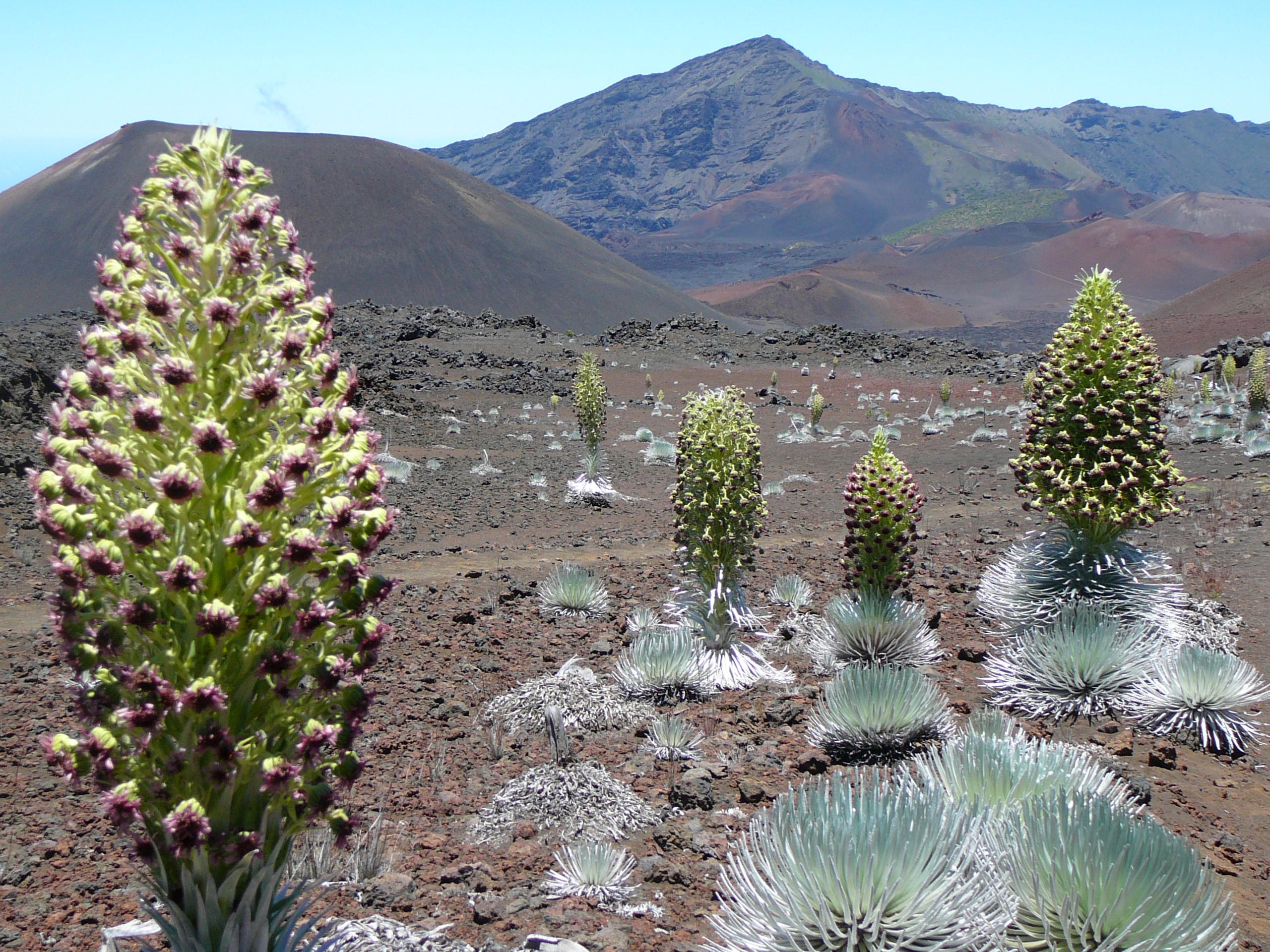
This special place vibrates with stories of ancient and modern Hawaiian culture and protects the bond between the land and its people. The park also cares for endangered species, some of which exist n...

11 mi from route ~29 min detour $25 near mile 8
Park Closure: Haleakalā Visitor Center Closed 2/19 through the week of 5/17
View on nps.gov

Park data from the National Park Service API. Alerts update every 2 hours.

Fuel & Cost

Regular Gas

$2.51 one way

$5.03 round trip

$5.51/gal 25.4 MPG avg 4 kg CO2
Fuel Type $/gal One Way Round Trip
midgrade $5.79 $2.64 $5.29
premium $5.98 $2.73 $5.46
diesel $5.61 $2.56 $5.12

No toll roads detected on this route.

Estimated Trip Cost (one way, 1 person)

Fuel

$3

Meals

$25–$50

Total

$28–$53

Rough estimate based on US averages. Hotel $80–$140/night, meals $25–$50/day.

Estimated CO2 emission: 4.1 kg one way. Prices: EIA weekly data, 2026-04-13.

EV Charging Along Route

2 DC fast chargers · Coverage: excellent

Kulamalu Center

Pukalani, HI

Non-Networked

4 DCFC

Pukalani Terrace Center provided by Hawaiian Electric

Makawao, HI

OpConnect

2 DCFC

OpConnect: 1 Non-Networked: 1

Station data from NREL Alternative Fuel Stations database.

Driving Electric?

About $1 in charging · 0 stops · 75% less CO2

Vehicle Type kWh Stops DC Fast Home Charge
Average EV 3.5 0 $1.22 $0.56
Efficient EV 2.9 0 $1.02 $0.46
EV Truck/SUV 4.6 0 $1.62 $0.74

Gas CO2

4 kg

EV CO2

1 kg (75% less)

This trip is well within single-charge range for most EVs. No charging stops needed if you start fully charged.

DC fast charging avg $0.35/kWh. Home charging avg $0.16/kWh. US grid CO2: 0.39 kg/kWh.

Travel Intel

Current conditions at both ends of the drive.

Forecast data refreshed 5 days ago

Origin

Makawao, HI

Afternoon in Makawao on Tuesday

Local time

2:50 PM

HST

Current temp

63°F

Unavailable

Live forecast

Destination

Kēōkea, HI

Afternoon in Kēōkea on Tuesday

Local time

2:50 PM

HST

Current temp

75°F

Unavailable

Live forecast

Seasonal Notes

Summer travel usually means heavier construction, hotter rest stops, and busier weekend traffic around major cities.

Winter travel shortens daylight, so a route that looks manageable on paper can feel much longer after dark.

Holiday weekends tend to make both departure and arrival windows slower than the raw route time suggests.

Time zone

Same local time

Origin and destination are on the same clock, so arrival timing is easier to judge at a glance.

Temperature spread

12 degrees warmer at arrival

A meaningful temperature swing is a good cue to rethink layers, water, and how soon you want to arrive.

Road read

21m on the road

Use the two city cards together: check the sky where you start, then compare it with the local time and temperature at arrival.

Weather data from the National Weather Service. Conditions may change; check closer to your travel date.

Frequently Asked Questions

The drive from Makawao, HI to Kēōkea, HI covers 11.6 miles and takes about 21m without stops. Add 15-30 minutes for a fuel or rest stop on longer drives.
The main roads are Kula Highway, Makawao Avenue, Baldwin Avenue. Expect a mix of highway and local road driving.
This is a comfortable same-day trip.
The midpoint is about 5.8 miles from Makawao, HI. Look for rest areas, gas stations, or food options near the halfway mark.
At current regular gas prices, expect to spend about $2.51 one way. This estimate uses 25.4 MPG — your actual cost will vary with your vehicle's fuel efficiency and current gas prices.
Leave by 9 AM and you'll arrive before lunch. Even a 4 PM departure gets you there before dark in summer.
The drive from Makawao, HI to Kēōkea, HI is easy. At 21m with 0% highway, most drivers will find it relaxed and low-stress.
The main spots that need attention: near the start (HI 390 / Baldwin Avenue): Navigation decision point; at 0.3 miles (HI 365 / Makawao Avenue): Navigation decision point; at 2 miles (HI 37 / Kula Highway): Lane positioning matters here.
The route from Makawao, HI to Kēōkea, HI does not surface many named destination signs beyond the main corridor.

Was this route helpful?

Thanks for your feedback!

Your tip has been submitted. Thanks!

/500

Explore More

Explore more options from Makawao, HI or browse trips ending in Kēōkea, HI.

Looking for more statewide routes? Browse HI road trips.

Explore maps for Makawao, HI or Kēōkea, HI on MapSof.net.