The drive from Many Farms, AZ to Tempe, AZ covers 311 miles and takes about 6h 41m behind the wheel.
This route is realistic as a one-day drive if you keep your stops efficient.
The route leans on South Beeline Highway, Purple Heart Trail, US 191 for much of the mileage,
and the overall profile is turn-heavy local drive.
The longest uninterrupted segment is about 72.8 miles on South Beeline Highway.
At current regular gas prices, budget about $61.96 one way before food or hotel costs.
Trip Pace
Same-day drive is realistic
A same-day return is possible, but it will make for a full day on the road.
Break Rhythm
1 planned break
Plan on a short reset every 3 to 4 hours to stay fresh behind the wheel.
Midpoint
155.5 miles from Many Farms, AZ
A natural place for your longest stop of the day
, about 3h 22m into the drive
.
Who Is This Route For?
Weekend Trip
Doable as a same-day drive at 6h 41m. Total distance: 311 miles.
Family Friendly
Moderate complexity with 1 natural rest stops along the way.
Solo Traveler
6h 41m drive, plan rest stops for pacing.
Scenic Drive
Turn-heavy local drive route profile with national parks nearby.
Drive Character
Expect a 6h 41m drive with frequent turns across 311 miles of local and secondary roads.
This route has more turning and local-road decision points than a simple highway run.
There are about 26 navigation steps in the underlying route data, so the final approach matters more than the middle miles.
South Beeline Highway is the longest continuous segment at about 72.8 miles.
How Hard Is This Drive?
Expect a hands-on drive with frequent turns and local roads rather than long highway stretches. There are only a few real navigation decisions along the way. The trickiest moment comes around 44.2 miles in near US 191.
Driving Effort4/10
Easy - simple navigation with a manageable amount of wheel time
Balances navigation complexity with total wheel time.
The route itself is not hard, but at 6h 41m, endurance matters. Plan breaks every 2-3 hours. The 15 decision points are all manageable with basic attention.
Where does it get tricky?
The main spots that need attention: at 44.2 miles (US 191): Roundabout - know your exit number before entering; at 133.9 miles (AZ 77): Exit ramp - move to the correct lane early. Multiple destination signs - pick the right one; at 304.7 miles (North Alma School Road): Lane positioning matters here.
Critical Maneuvers
5 of 15 key points
These are the spots where you need to pay the most attention. Preview them before you drive.
5
44.2 mi into trip|~1h 5m in|US 191
Enter roundabout onto US 191
Roundabout - know your exit number before entering
5
133.9 mi into trip|~2h 54m in|AZ 77
Take the exit onto AZ 77 toward I 40 Business, AZ 77 South, AZ 377 South, US 180 East: Show Low, Heber
Exit ramp - move to the correct lane early. Multiple destination signs - pick the right one
Toward I 40 Business, AZ 77 South, AZ 377 South...
6
304.7 mi into trip|~6h 30m in|North Alma School Road
Turn left onto North Alma School Road
Lane positioning matters here
Use the left lane.
5
308.5 mi into trip|~6h 36m in|North McClintock Drive
Turn left onto North McClintock Drive
Lane positioning matters here
Use the left lane.
6
311 mi into trip|~6h 41m in|US 80 Hist / East Apache Boulevard
Turn right onto US 80 Hist / East Apache Boulevard
Lane positioning matters here
Use the right lane.
Towns Mentioned on Route Signs
Based on OSRM destination-sign hints, not a full list of every settlement the road passes.
On the drive from Many Farms, AZ to Tempe, AZ, road signs begin pointing toward Heber along the way.
Heber
133.9 mi in|~2h 54m|via AZ 77
Main Roads
Road
Distance
Duration
South Beeline Highway
72.8 mi
1h 26m
Purple Heart Trail
45.7 mi
45m
US 191
43.7 mi
1h 2m
Heber Road
30.9 mi
36m
Chambers-Mexican Water Highway
30.7 mi
45m
Payson-Show Low Highway
24.2 mi
30m
Hwy 260
15.9 mi
22m
US Highway 191
13.4 mi
19m
Longest stretch:
South Beeline Highway
— 72.8 mi, about 1h 26m
Turn-by-Turn Driving Directions
Step-by-step road directions between Many Farms, AZ and Tempe, AZ.
1
Start on US 191
13 mi·19 min·US Highway 191
2
Continue on US 191
31 mi·45 min·Chambers-Mexican Water Highway
3
Enter roundabout onto US 191
278 ft·3 sec·US 191
4
Continue on US 191
5.9 mi·6 min·US 191
5
Turn right onto US 191
38 mi·56 min·US 191
6
Take the ramp
0.3 mi·33 sec
7
Merge onto I 40
46 mi·45 min·Purple Heart Trail
8
Take the exit onto AZ 77
0.4 mi·50 sec·AZ 77
Toward I 40 Business, AZ 77 South, AZ 377 South, US 180 East: Show Low, Heber
9
Turn left onto I 40 Bus; AZ 77; US 66 Hist
1.2 mi·2 min·Navajo Boulevard
10
Continue on US 180; AZ 77
0.5 mi·56 sec·Holbrook-Springerville Highway
11
Continue on AZ 77
1.6 mi·2 min·Show Low-Holbrook Highway
12
Turn right onto AZ 377
31 mi·36 min·Heber Road
13
Turn straight onto AZ 377
2.9 mi·3 min·Heber-Holbrook Highway
14
At end of road, turn right onto AZ 277
4.9 mi·6 min·West 3rd Street North
15
Continue on AZ 277
1.9 mi·3 min·Highway 277
16
At end of road, turn right onto AZ 260
0.2 mi·19 sec·Highway 260
17
Continue on AZ 260
16 mi·22 min·Hwy 260
18
Continue on AZ 260
13 mi·17 min·Payson-Heber Highway
Use the straight lane.
19
Continue on AZ 260
24 mi·30 min·Payson-Show Low Highway
Use the straight lane.
20
Turn left onto AZ 87
73 mi·1 hr 26 min·South Beeline Highway
Use the left lane.
21
Turn right onto East McDowell Road
0.8 mi·1 min·East McDowell Road
22
Turn left onto North Alma School Road
0.7 mi·1 min·North Alma School Road
Use the left lane.
23
Turn right onto East McKellips Road
3.1 mi·4 min·East McKellips Road
24
Turn left onto North McClintock Drive
2.5 mi·4 min·North McClintock Drive
Use the left lane.
25
Turn right onto US 80 Hist
60 ft·1 sec·East Apache Boulevard
Use the right lane.
26
Arrive at destination
US 80 Hist
Trip Plan
Morning Departure
Start early — leave by 6-7 AM to arrive at a reasonable hour.
Evening Departure
This is a long drive — plan for a morning departure or consider splitting it into two days.
You can normally do this drive in one day.
Plan roughly 1 meaningful break for fuel, food, and rest.
The halfway point lands around 155.5 miles from Many Farms, AZ, or about 3h 22m into the drive.
The longest continuous stretch on this route runs about 72.8 miles.
This is a comfortable same-day trip.
Departure
Before you leave
Start with fuel, water, and navigation already sorted so the first hour feels easy.
First stop
Around 68 miles or 1h 39m in
Use this first pause for coffee, a restroom break, and a quick traffic check ahead.
Halfway reset
Around 155.5 miles or 3h 22m in
This is the best place for your longest stop, a real meal, and a full fuel check.
Final approach
Final hour starts around 5h 31m
Traffic, exits, and arrival timing usually matter more near Tempe, AZ than in the middle of the route.
Before You Leave
+
Open the route before leaving Many Farms, AZ so your first major turns are already loaded.
+
Leave with enough water and a charging cable within reach, not packed away.
+
Check your fuel range against the first long segment, especially if you are starting outside city service areas.
Day 1
Settle into the route from Many Farms, AZ
This is one driving day of about 311 miles and 6h 41m.
Your first comfortable stop window is around 68 miles from Many Farms, AZ.
This route can stay practical as a one-day drive if traffic stays reasonable.
Plan about 1 real break rather than only quick fuel stops.
The longest stretch is on South Beeline Highway for about 72.8 miles.
Where to Stop
Rest stops, refuel points, and overnight suggestions along this route.
Halfway Point
Midpoint
About 155.5 mi from Many Farms, AZ
· 3h 22m into the drive
Place data sourced from public business listings. Hours and availability may vary.
National Parks Near This Route
Worth a detour if your schedule allows.
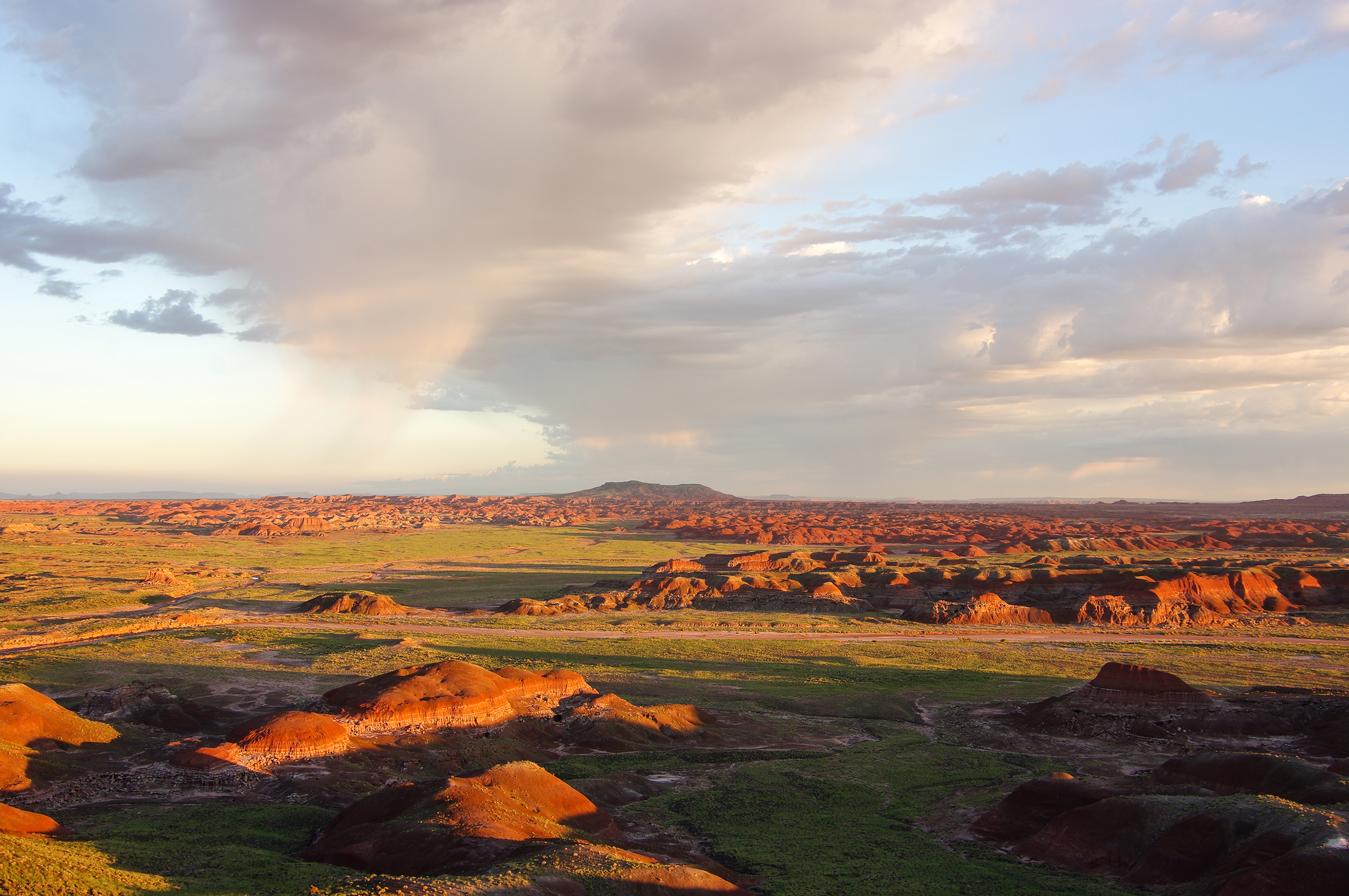
Petrified Forest National Park
National Park
A landscape where deep time lies fully on display, Petrified Forest National Park blends colorful badlands, vast grasslands, and one of the world’s largest and most vivid collections of petrified wood...
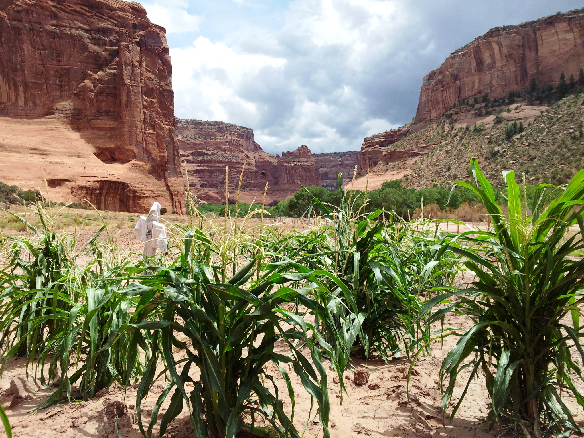
This canyon is home to Diné families who raise livestock, grow crops and live here. People have lived in these canyons for nearly 5,000 years, which is longer than anyone has lived continuously on the...
15 mi from route
~38 min detour
Free
near mile 10.7
Located within the northern range of the Sonoran Desert lie two cliff dwellings that were occupied from 1300-1450 CE (common era). They represent a vibrant culture consisting of local and immigrant gr...
23 mi from route
~57 min detour
$10
near mile 278.8
Park data from the National Park Service API. Alerts update every 2 hours.
Fuel & Cost
Regular Gas
$61.96 one way
$123.91 round trip
$5.06/gal25.4 MPG avg109 kg CO2
Fuel Type
$/gal
One Way
Round Trip
midgrade
$5.36
$65.57
$131.13
premium
$5.59
$68.46
$136.91
diesel
$5.61
$68.66
$137.33
No toll roads detected on this route.
Estimated Trip Cost (one way, 1 person)
Fuel
$62
Meals
$25–$50
Total
$87–$112
Rough estimate based on US averages. Hotel $80–$140/night, meals $25–$50/day.
Estimated CO2 emission: 108.8 kg one way.
Prices: EIA weekly data, 2026-04-13.
Driving Electric?
About $33 in charging
· 1 stop
· 67% less CO2
Vehicle Type
kWh
Stops
DC Fast
Home Charge
Average EV
93.3
1
$32.65
$14.93
Efficient EV
77.8
0
$27.21
$12.44
EV Truck/SUV
124.4
1
$43.54
$19.90
Gas CO2
109 kg
EV CO2
36 kg (67% less)
Plan for 1 charging stop. A 30-minute DC fast charge mid-route should be enough to complete the trip comfortably.
DC fast charging avg $0.35/kWh. Home charging avg $0.16/kWh. US grid CO2: 0.39 kg/kWh.
Travel Intel
Current conditions at both ends of the drive.
Forecast as of Apr 15, 2026
Origin
Many Farms, AZ
Afternoon
in Many Farms on Friday
Local time
2:47 PM
MDT
Current temp
40°F
Unavailable
Live forecast
Destination
Tempe, AZ
Afternoon
in Tempe on Friday
Local time
1:47 PM
MST
Current temp
93°F
Unavailable
Live forecast
Seasonal Notes
Summer travel usually means heavier construction, hotter rest stops, and busier weekend traffic around major cities.
Winter travel shortens daylight, so a route that looks manageable on paper can feel much longer after dark.
Holiday weekends tend to make both departure and arrival windows slower than the raw route time suggests.
Time zone
1 hour earlier
The destination clock does not match departure time, so double-check hotel check-in windows and late arrival plans.
Temperature spread
53 degrees warmer at arrival
A meaningful temperature swing is a good cue to rethink layers, water, and how soon you want to arrive.
Road read
6h 41m on the road
Start early — leave by 6-7 AM to arrive at a reasonable hour.
Weather data from the National Weather Service. Conditions may change; check closer to your travel date.
Frequently Asked Questions
The drive from Many Farms, AZ to Tempe, AZ covers 311 miles and takes about 6h 41m without stops. Add 15-30 minutes for a fuel or rest stop on longer drives.
The main roads are South Beeline Highway, Purple Heart Trail, US 191. Expect a mix of highway and local road driving.
This is a comfortable same-day trip.
The midpoint is about 155.5 miles from Many Farms, AZ. Look for rest areas, gas stations, or food options near the halfway mark.
At current regular gas prices, expect to spend about $61.96 one way. This estimate uses 25.4 MPG — your actual cost will vary with your vehicle's fuel efficiency and current gas prices.
Start early — leave by 6-7 AM to arrive at a reasonable hour. This is a long drive — plan for a morning departure or consider splitting it into two days.
Plan about 1 meaningful break for fuel, food, or rest. Plan on a short reset every 3 to 4 hours to stay fresh behind the wheel.
The route itself is not hard, but at 6h 41m, endurance matters. Plan breaks every 2-3 hours. The 15 decision points are all manageable with basic attention.
The main spots that need attention: at 44.2 miles (US 191): Roundabout - know your exit number before entering; at 133.9 miles (AZ 77): Exit ramp - move to the correct lane early. Multiple destination signs - pick the right one; at 304.7 miles (North Alma School Road): Lane positioning matters here.
On the drive from Many Farms, AZ to Tempe, AZ, road signs begin pointing toward Heber along the way.
Yes. Nearby national parks include Petrified Forest National Park, Canyon de Chelly National Monument and Tonto National Monument.
How this page is built
Compiled by the Trip.ovh planning team at COD Solutions Oy from open government datasets — OSRM over OpenStreetMap for geometry, EIA for fuel prices, and NPS for national parks. See our methodology for refresh cadence and limitations.