The drive from Marionville, MO to Castle Point, MO covers 246 miles and takes about 4h 48m behind the wheel.
This route is realistic as a one-day drive if you keep your stops efficient.
The route leans on Congressman Mel Hancock Freeway, US 60, MO MM for much of the mileage,
and the overall profile is highway-focused drive.
The longest uninterrupted segment is about 206.7 miles on Congressman Mel Hancock Freeway.
At current regular gas prices, budget about $38.46 one way before food or hotel costs.
Trip Pace
Same-day drive is realistic
A same-day return is possible, but it will make for a full day on the road.
Break Rhythm
1 planned break
Plan on a short reset every 3 to 4 hours to stay fresh behind the wheel.
Midpoint
123 miles from Marionville, MO
A natural place for your longest stop of the day
, about 2h 22m into the drive
.
Who Is This Route For?
Weekend Trip
Doable as a same-day drive at 4h 48m. Total distance: 246 miles.
Family Friendly
Moderate complexity with 1 natural rest stops along the way.
Solo Traveler
4h 48m drive, comfortable solo distance.
First-Time Driver
Mostly highway driving (90%). Some complex stretches to watch for.
Drive Character
This is a 4h 48m highway drive covering 246 miles, with most of the trip on Congressman Mel Hancock Freeway and US 60. The longest continuous stretch is about 206.7 miles on Congressman Mel Hancock Freeway.
Most of the miles stay on highways, which makes pacing and fuel planning easier than turn-by-turn city driving.
There are about 21 navigation steps in the underlying route data, so the final approach matters more than the middle miles.
Congressman Mel Hancock Freeway is the longest continuous segment at about 206.7 miles.
How Hard Is This Drive?
This is a straightforward highway drive that stays mostly on Congressman Mel Hancock Freeway and US 60. You will hit about 13 points where you need to pay attention to lane position or signs. The trickiest moment comes around 0.7 miles in near US 60.
Driving Effort5/10
Moderate - straightforward overall, but long enough or busy enough to require pacing
Balances navigation complexity with total wheel time.
This drive requires moderate attention. Across 246 miles you will encounter 13 spots where lane choice or exit timing matters. Not difficult for experienced highway drivers, but worth previewing the tricky sections before you go.
Where does it get tricky?
The main spots that need attention: at 0.7 miles (US 60): Navigation decision point; at 19.9 miles (I 44 / Congressman Mel Hancock Freeway): Merge point - match speed before joining. Lane positioning matters here; at 233.6 miles: Exit ramp - move to the correct lane early. Lane positioning matters here.
Critical Maneuvers
5 of 13 key points
These are the spots where you need to pay the most attention. Preview them before you drive.
5
0.7 mi into trip|~1m in|US 60
At end of road, turn left onto US 60
Navigation decision point
5
19.9 mi into trip|~30m in|I 44 / Congressman Mel Hancock Freeway
Merge onto I 44 / Congressman Mel Hancock Freeway
Merge point - match speed before joining. Lane positioning matters here
Use the straight / slight right lanes.
7
233.6 mi into trip|~4h 24m in
Take the exit toward Jamieson Avenue
Exit ramp - move to the correct lane early. Lane positioning matters here
Use the slight right lane.
Exit 284
Toward Jamieson Avenue
6
233.7 mi into trip|~4h 24m in
Keep slight left at fork toward Jamieson Avenue
Highway fork - watch signs carefully
Toward Jamieson Avenue
5
233.7 mi into trip|~4h 24m in|Jamieson Avenue
Turn left onto Jamieson Avenue
Lane positioning matters here
Use the left / straight lanes.
Main Roads
Road
Distance
Duration
Congressman Mel Hancock Freeway
206.7 mi
3h 45m
US 60
15.1 mi
22m
MO MM
3.9 mi
6m
Police Officer Ernest M. Brockman Sr. Memorial Highway
Place data sourced from public business listings. Hours and availability may vary.
National Parks Near This Route
Worth a detour if your schedule allows.
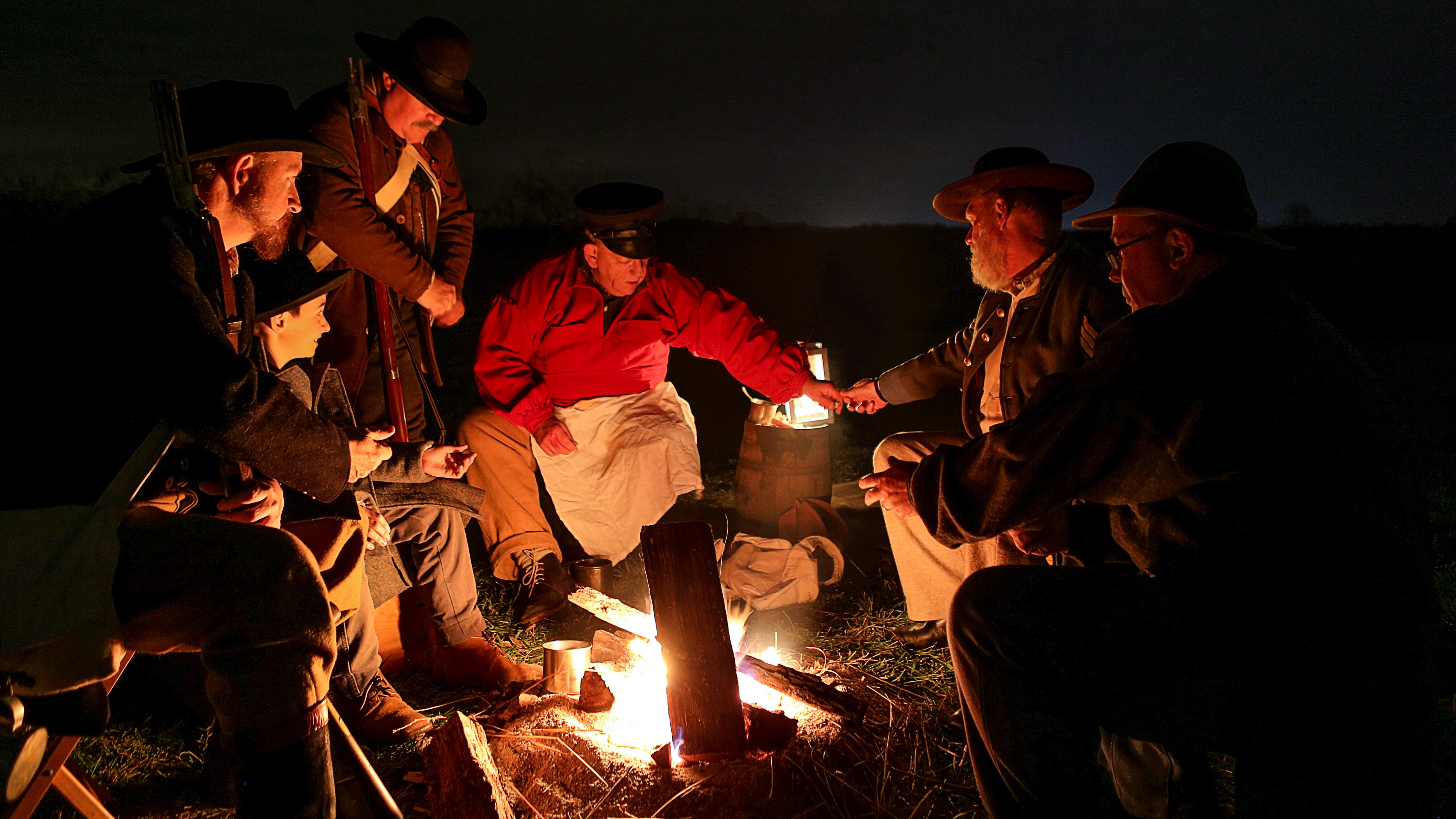
Wilson's Creek National Battlefield
National Battlefield
Wilson's Creek was the first major Civil War battle fought west of the Mississippi River, and where the first Union general was killed in action. The costly Southern victory on August 10, 1861, focuse...
Gateway Arch National Park commemorates President Jefferson’s vision of a continental nation, the individuals and cultural groups who helped shape its history, St. Louis’ role in westward expansion, a...
6 mi from route
~16 min detour
$19
near mile 237.5
Park data from the National Park Service API. Alerts update every 2 hours.
Fuel & Cost
Regular Gas
$38.46 one way
$76.92 round trip
$3.97/gal25.4 MPG avg86 kg CO2
Fuel Type
$/gal
One Way
Round Trip
midgrade
$4.36
$42.23
$84.45
premium
$4.89
$47.34
$94.68
diesel
$5.61
$54.31
$108.63
No toll roads detected on this route.
Estimated Trip Cost (one way, 1 person)
Fuel
$38
Meals
$25–$50
Total
$63–$88
Rough estimate based on US averages. Hotel $80–$140/night, meals $25–$50/day.
Estimated CO2 emission: 86.1 kg one way.
Prices: EIA weekly data, 2026-04-13.
EV Charging Along Route
19 DC fast chargers
· Coverage: excellent
Dynamic EVC Charging Station
Republic, Missouri
Other
1 DCFC
Dynamic Charging Station
Springfield, Missouri
Other
1 DCFC
Blink Charging Station
Marshfield, Missouri
Blink
1 DCFC
ChargePoint Charging Station
Springfield, Missouri
ChargePoint
1 DCFC
Tesla Supercharger
Springfield, Missouri
Tesla
1 DCFC
Tesla Supercharger
St Robert, Missouri
Tesla
1 DCFC
Mercedes-Benz Charging Station
Springfield, Missouri
Other
1 DCFC
Flying J EV Charging Station
Springfield, Missouri
Other
1 DCFC
Blink: 6
Other: 5
ChargePoint: 2
Tesla: 2
EV Connect: 2
Tesla Destination: 1
Electrify America: 1
Station data from NREL Alternative Fuel Stations database.
Driving Electric?
About $26 in charging
· 0 stops
· 66% less CO2
Vehicle Type
kWh
Stops
DC Fast
Home Charge
Average EV
73.8
0
$25.83
$11.81
Efficient EV
61.5
0
$21.53
$9.84
EV Truck/SUV
98.4
1
$34.44
$15.74
Gas CO2
86 kg
EV CO2
29 kg (66% less)
Plan for 0 charging stops, roughly every 270 miles. Allow 25-40 minutes per stop at a DC fast charger.
DC fast charging avg $0.35/kWh. Home charging avg $0.16/kWh. US grid CO2: 0.39 kg/kWh.
Travel Intel
Current conditions at both ends of the drive.
Forecast as of Apr 14, 2026
Origin
Marionville, MO
Night
in Marionville on Friday
Local time
10:49 PM
CDT
Current temp
54°F
Unavailable
Live forecast
Destination
Castle Point, MO
Night
in Castle Point on Friday
Local time
10:49 PM
CDT
Current temp
67°F
Slight Chance Showers And Thunderstorms
SW 10 mph18% chanceLive forecast
Flood Warning
Flood Warning issued April 14 at 3:14AM CDT until April 15 at 7:23PM CDT by NWS Kansas City/Pleasant Hill MO
Flood Warning
Flood Warning issued April 13 at 9:43PM CDT until April 18 at 7:00PM CDT by NWS St Louis MO
74°F
Washington, MO
123 mi in
Seasonal Notes
Summer travel usually means heavier construction, hotter rest stops, and busier weekend traffic around major cities.
Winter travel shortens daylight, so a route that looks manageable on paper can feel much longer after dark.
Holiday weekends tend to make both departure and arrival windows slower than the raw route time suggests.
Time zone
Same local time
Origin and destination are on the same clock, so arrival timing is easier to judge at a glance.
Temperature spread
13 degrees warmer at arrival
A meaningful temperature swing is a good cue to rethink layers, water, and how soon you want to arrive.
Road read
4h 48m on the road
An early start around 7-8 AM gets you there with plenty of daylight left.
Weather data from the National Weather Service. Conditions may change; check closer to your travel date.
Frequently Asked Questions
The drive from Marionville, MO to Castle Point, MO covers 246 miles and takes about 4h 48m without stops. Add 15-30 minutes for a fuel or rest stop on longer drives.
The main roads are Congressman Mel Hancock Freeway, US 60, MO MM. Most of the drive stays on highways, so watch for ramps and exits.
This is a comfortable same-day trip.
The midpoint is about 123 miles from Marionville, MO. Look for rest areas, gas stations, or food options near the halfway mark.
At current regular gas prices, expect to spend about $38.46 one way. This estimate uses 25.4 MPG — your actual cost will vary with your vehicle's fuel efficiency and current gas prices.
An early start around 7-8 AM gets you there with plenty of daylight left. A late afternoon start means arriving after dark. Morning is better.
Plan about 1 meaningful break for fuel, food, or rest. Plan on a short reset every 3 to 4 hours to stay fresh behind the wheel.
This drive requires moderate attention. Across 246 miles you will encounter 13 spots where lane choice or exit timing matters. Not difficult for experienced highway drivers, but worth previewing the tricky sections before you go.
The main spots that need attention: at 0.7 miles (US 60): Navigation decision point; at 19.9 miles (I 44 / Congressman Mel Hancock Freeway): Merge point - match speed before joining. Lane positioning matters here; at 233.6 miles: Exit ramp - move to the correct lane early. Lane positioning matters here.
The route from Marionville, MO to Castle Point, MO does not surface many named destination signs beyond the main corridor.
Yes. Nearby national parks include Wilson's Creek National Battlefield and Gateway Arch National Park.
How this page is built
Compiled by the Trip.ovh planning team at COD Solutions Oy from open government datasets — OSRM over OpenStreetMap for geometry, EIA for fuel prices, NREL for EV charging, and NPS for national parks. See our methodology for refresh cadence and limitations.