This 80.5-mile drive from Mesquite, NM to Alamogordo, NM takes about 1 hour and 36 minutes, making it a perfect one-day trip. You'll primarily be on US Highway 70 West, also known as Bataan Memorial Highway and Pearl Harbor Memorial Highway, with about 63% of the journey on major roadways. The estimated fuel cost for this route is around $12. This highway-focused drive through the Desert Southwest is straightforward and efficient, ideal for travelers looking for a direct path between these two New Mexico locations. It's a manageable distance that doesn't require an overnight stay.
Trip Pace
Same-day drive is realistic
A same-day return is realistic if you keep stops short.
Break Rhythm
0 planned breaks
A short stop every 2 to 3 hours is enough for this drive.
Midpoint
40.2 miles from Mesquite, NM
A natural place for your longest stop of the day
, about 49m into the drive
.
Loading map...
Drive Character
Expect a highway-focused drive for most of this 80.5-mile trip. With 63% of the route on main roads like US Highway 70 West, you'll experience a good amount of continuous travel. The longest uninterrupted stretch is 42.3 miles on US Highway 70 West, offering a chance to settle into a steady pace. While primarily highway, the road's character can evolve, offering a mix of open stretches and potentially more developed sections as you approach your destination. This drive is designed for efficiency and consistent speed.
Most of the miles stay on highways, which makes pacing and fuel planning easier than turn-by-turn city driving.
There are about 16 navigation steps in the underlying route data, so the final approach matters more than the middle miles.
US Highway 70 West is the longest continuous segment at about 42.3 miles.
How Hard Is This Drive?
This is a straightforward highway drive that stays mostly on US Highway 70 West and Bataan Memorial Highway. This route has several spots where lane changes, forks, or exits need your full attention. The trickiest moment comes around 2.4 miles in.
Route Complexity7/10
Demanding - plan breaks and stay ahead of the key maneuvers
This is a demanding drive. With 10 significant decision points across 80.5 miles, you will need to stay alert — especially through interchange areas and urban stretches. Consider splitting it into segments if you are not comfortable with fast highway navigation.
Where does it get tricky?
The main spots that need attention: at 2.4 miles: Navigation decision point; at 8.9 miles: Exit ramp - move to the correct lane early. Multiple destination signs - pick the right one; at 15.6 miles: Exit ramp - move to the correct lane early. Multiple destination signs - pick the right one.
Critical Maneuvers
5 of 10 key points
These are the spots where you need to pay the most attention. Preview them before you drive.
5
2.4 mi into trip|~4m in
Take the ramp
Navigation decision point
5
8.9 mi into trip|~11m in
Take the exit toward I 25 North: Las Cruces, Albuquerque
Exit ramp - move to the correct lane early. Multiple destination signs - pick the right one
Toward I 25 North: Las Cruces, Albuquerque
5
15.6 mi into trip|~20m in
Take the exit toward US 70: Las Cruces, Alamogordo
Exit ramp - move to the correct lane early. Multiple destination signs - pick the right one
Toward US 70: Las Cruces, Alamogordo
7
15.7 mi into trip|~20m in
Keep slight left at fork toward US 70: Las Cruces, Alamogordo
Highway fork - watch signs carefully. Multiple destination signs - pick the right one
Toward US 70: Las Cruces, Alamogordo
6
15.8 mi into trip|~20m in
Keep slight right at fork toward US 70 East: Alamogordo
Highway fork - watch signs carefully
Toward US 70 East: Alamogordo
Towns Mentioned on Route Signs
Based on OSRM destination-sign hints, not a full list of every settlement the road passes.
On the drive from Mesquite, NM to Alamogordo, NM, road signs begin pointing toward Albuquerque along the way.
Albuquerque
8.9 mi in|~11m
Main Roads
Road
Distance
Duration
US Highway 70 West
42.3 mi
46m
Bataan Memorial Highway
19.9 mi
23m
Pearl Harbor Memorial Highway
6.3 mi
6m
I 25
5.7 mi
6m
State Highway 228
1.8 mi
3m
South White Sands Boulevard
1.6 mi
3m
North White Sands Boulevard
0.6 mi
1m
FR 1035
0.4 mi
<1m
Longest stretch:
US Highway 70 West
— 42.3 mi, about 46m
Turn-by-Turn Driving Directions
Step-by-step road directions between Mesquite, NM and Alamogordo, NM.
1
Start on NM 478
347 ft·13 sec·Highway 478
2
Turn left onto NM 228
1.8 mi·3 min·State Highway 228
3
At end of road, turn left onto FR 1035
0.4 mi·45 sec·FR 1035
4
Turn right onto Mossman Arroyo Road
0.1 mi·19 sec·Mossman Arroyo Road
5
Take the ramp
0.2 mi·25 sec
6
Merge onto I 10
6.3 mi·6 min·Pearl Harbor Memorial Highway
7
Take the exit
1.0 mi·2 min
Toward I 25 North: Las Cruces, Albuquerque
8
Continue on I 25
5.7 mi·6 min·I 25
9
Take the exit
0.1 mi·17 sec
Toward US 70: Las Cruces, Alamogordo
10
Keep slight left at fork
354 ft·8 sec
Toward US 70: Las Cruces, Alamogordo
11
Keep slight right at fork
0.2 mi·28 sec
Toward US 70 East: Alamogordo
12
Merge onto US 70
20 mi·23 min·Bataan Memorial Highway
Use the slight right lane.
13
Continue on US 70
42 mi·46 min·US Highway 70 West
Use the straight lane.
14
Continue on US 70
1.6 mi·3 min·South White Sands Boulevard
Use the straight lane.
15
Continue on North White Sands Boulevard
0.6 mi·1 min·North White Sands Boulevard
Use the left / straight / right lanes.
16
Arrive at destination
North White Sands Boulevard
Trip Plan
Given the short 1 hour and 36 minute duration, this route offers great flexibility. You can easily depart anytime, but an early morning start will allow ample time for exploration in Alamogordo. With no designated stops in the data, plan your own breaks as needed, perhaps around the halfway point or when you feel the need to stretch. Keep an eye on your fuel gauge, as the longest stretch without potential services is 42.3 miles on US Highway 70 West. The $12 fuel estimate is a good baseline, but always factor in a buffer. This is a quick, efficient journey so focus on enjoying the scenery as it unfolds.
Morning Departure
Leave by 9 AM and you'll arrive before lunch.
Evening Departure
Even a 4 PM departure gets you there before dark in summer.
You can normally do this drive in one day.
You may only need one short stretch break if traffic stays light.
The halfway point lands around 40.2 miles from Mesquite, NM, or about 49m into the drive.
The longest continuous stretch on this route runs about 42.3 miles.
This is a comfortable same-day trip.
Departure
Before you leave
Start with fuel, water, and navigation already sorted so the first hour feels easy.
First stop
Around 80 miles or 1h 35m in
Use this first pause for coffee, a restroom break, and a quick traffic check ahead.
Halfway reset
Around 40.2 miles or 49m in
This is the best place for your longest stop, a real meal, and a full fuel check.
Final approach
Final hour starts around 1h 20m
Traffic, exits, and arrival timing usually matter more near Alamogordo, NM than in the middle of the route.
Before You Leave
+
Open the route before leaving Mesquite, NM so your first major turns are already loaded.
+
Leave with enough water and a charging cable within reach, not packed away.
+
Check your fuel range against the first long segment, especially if you are starting outside city service areas.
Day 1
Settle into the route from Mesquite, NM
This is one driving day of about 80.5 miles and 1h 36m.
Your first comfortable stop window is around 80 miles from Mesquite, NM.
This route can stay practical as a one-day drive if traffic stays reasonable.
You may only need one short stretch stop if conditions stay smooth.
The longest stretch is on US Highway 70 West for about 42.3 miles.
Where to Stop
Rest stops, refuel points, and overnight suggestions along this route.
Halfway Point
Midpoint
About 40.2 mi from Mesquite, NM
· 49m into the drive
The midpoint is around 40.2 miles from Mesquite, NM, which is a good place for a longer meal and fuel stop.
Arriving in Alamogordo, NM
The final approach into Alamogordo, NM usually feels slower than the middle of the drive, so avoid planning your tightest schedule at the very end.
Try to arrive with enough fuel left to skip an immediate station stop unless you already know the area around Alamogordo, NM.
These stop ideas are pacing suggestions — the exact town or exit can change with traffic, hotel plans, and fuel range.
National Parks Near This Route
Worth a detour if your schedule allows.
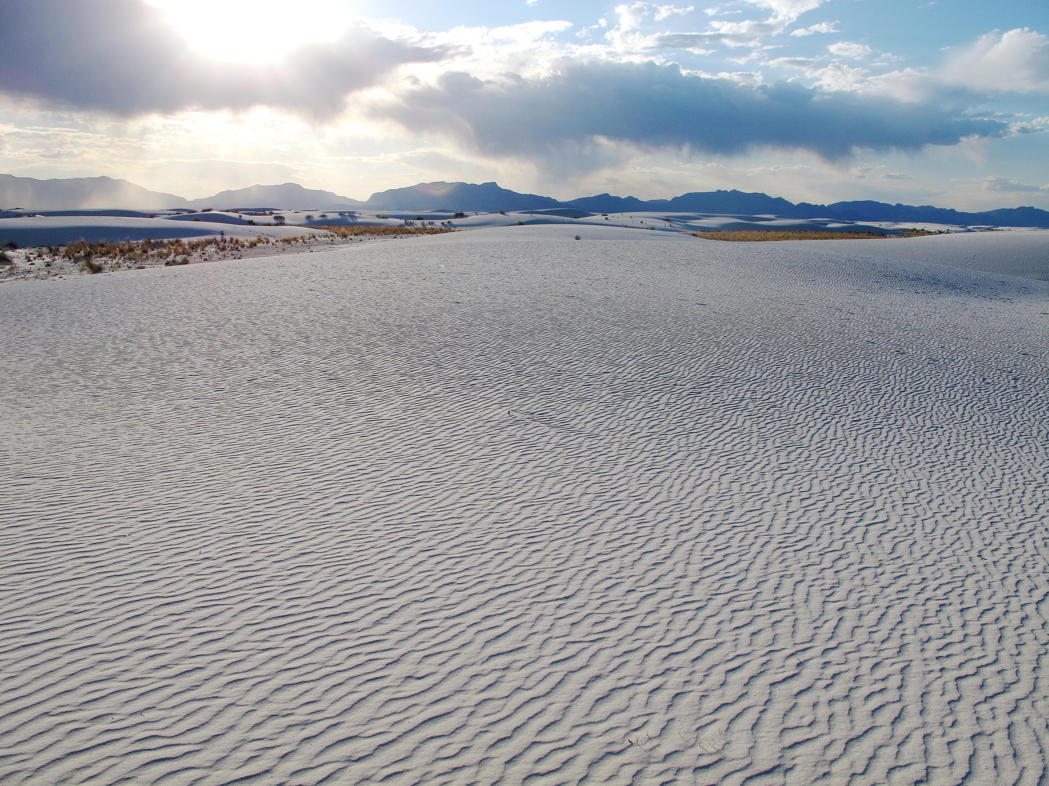
White Sands National Park
National Park
Rising from the heart of the Tularosa Basin is one of the world's great natural wonders - the glistening white sands of New Mexico. Great wave-like dunes of gypsum sand have engulfed 275 square miles...
Park data from the National Park Service API. Alerts update every 2 hours.
Fuel & Cost
Regular Gas
$12.16 one way
$24.31 round trip
$3.84/gal25.4 MPG avg28 kg CO2
Fuel Type
$/gal
One Way
Round Trip
midgrade
$4.21
$13.35
$26.69
premium
$4.56
$14.45
$28.90
diesel
$5.61
$17.77
$35.55
No toll roads detected on this route.
Estimated Trip Cost (one way, 1 person)
Fuel
$12
Meals
$25–$50
Total
$37–$62
Rough estimate based on US averages. Hotel $80–$140/night, meals $25–$50/day.
Estimated CO2 emission: 28.2 kg one way.
Prices: EIA weekly data, 2026-04-13.
Driving Electric?
About $8 in charging
· 0 stops
· 68% less CO2
Vehicle Type
kWh
Stops
DC Fast
Home Charge
Average EV
24.2
0
$8.45
$3.86
Efficient EV
20.1
0
$7.04
$3.22
EV Truck/SUV
32.2
0
$11.27
$5.15
Gas CO2
28 kg
EV CO2
9 kg (68% less)
This trip is well within single-charge range for most EVs. No charging stops needed if you start fully charged.
DC fast charging avg $0.35/kWh. Home charging avg $0.16/kWh. US grid CO2: 0.39 kg/kWh.
Travel Intel
Current conditions at both ends of the drive.
Forecast data refreshed 4 days ago
Origin
Mesquite, NM
Morning
in Mesquite on Wednesday
Local time
6:13 AM
MDT
Current temp
81°F
Unavailable
Live forecast
Destination
Alamogordo, NM
Morning
in Alamogordo on Wednesday
Local time
6:13 AM
MDT
Current temp
47°F
Unavailable
Live forecast
Seasonal Notes
Summer travel usually means heavier construction, hotter rest stops, and busier weekend traffic around major cities.
Winter travel shortens daylight, so a route that looks manageable on paper can feel much longer after dark.
Holiday weekends tend to make both departure and arrival windows slower than the raw route time suggests.
Time zone
Same local time
Origin and destination are on the same clock, so arrival timing is easier to judge at a glance.
Temperature spread
34 degrees cooler at arrival
A meaningful temperature swing is a good cue to rethink layers, water, and how soon you want to arrive.
Road read
1h 36m on the road
Use the two city cards together: check the sky where you start, then compare it with the local time and temperature at arrival.
Weather data from the National Weather Service. Conditions may change; check closer to your travel date.
Frequently Asked Questions
The drive from Mesquite, NM to Alamogordo, NM covers 80.5 miles and takes about 1h 36m without stops. Add 15-30 minutes for a fuel or rest stop on longer drives.
The main roads are US Highway 70 West, Bataan Memorial Highway, Pearl Harbor Memorial Highway. Most of the drive stays on highways, so watch for ramps and exits.
This is a comfortable same-day trip.
The midpoint is about 40.2 miles from Mesquite, NM. Look for rest areas, gas stations, or food options near the halfway mark.
At current regular gas prices, expect to spend about $12.16 one way. This estimate uses 25.4 MPG — your actual cost will vary with your vehicle's fuel efficiency and current gas prices.
Leave by 9 AM and you'll arrive before lunch. Even a 4 PM departure gets you there before dark in summer.
This is a demanding drive. With 10 significant decision points across 80.5 miles, you will need to stay alert — especially through interchange areas and urban stretches. Consider splitting it into segments if you are not comfortable with fast highway navigation.
The main spots that need attention: at 2.4 miles: Navigation decision point; at 8.9 miles: Exit ramp - move to the correct lane early. Multiple destination signs - pick the right one; at 15.6 miles: Exit ramp - move to the correct lane early. Multiple destination signs - pick the right one.
On the drive from Mesquite, NM to Alamogordo, NM, road signs begin pointing toward Albuquerque along the way.