
Trip from Metairie, LA to Eastwood, LA

Last recalculated Apr 16, 2026

Drive Time

6h 12m

Distance

331.3 mi

533 km

Drive Score

10/10

Great drive

Same Day?

Yes, doable

Fuel Cost

$50

one way

EV Charging

Unknown

Best Time to Leave

Save up to 38 min
4 AM
5h 59m ★
6 AM
6h 12m
8 AM
6h 37m
10 AM
6h 21m
12 PM
6h 18m
3 PM
6h 22m
5 PM
6h 36m
8 PM
6h 4m

Estimated drive times based on typical traffic patterns. Actual times may vary with weather, construction, and real-time conditions.

unincorporated suburban community and census-designated places in Jefferson Parish, Louisiana, United States

Metairie, LA

Wikimedia Commons

Downtown Eastwood, LA, LA

Eastwood, LA

Daniil Vishnevskiy

Trip Overview

The drive from Metairie, LA to Eastwood, LA covers 331.3 miles and takes about 6h 12m behind the wheel. This route is realistic as a one-day drive if you keep your stops efficient.

The route leans on Charles I. "Doc" Hudson Highway, I 10, State Route 1 for much of the mileage, and the overall profile is mixed drive. The longest uninterrupted segment is about 186.3 miles on Charles I. "Doc" Hudson Highway. At current regular gas prices, budget about $50.03 one way before food or hotel costs.

Trip Pace

Same-day drive is realistic

A same-day return is possible, but it will make for a full day on the road.

Break Rhythm

1 planned break

Plan on a short reset every 3 to 4 hours to stay fresh behind the wheel.

Midpoint

165.6 miles from Metairie, LA

A natural place for your longest stop of the day , about 3h 16m into the drive .

Who Is This Route For?

Weekend Trip

Doable as a same-day drive at 6h 12m. Total distance: 331.3 miles.

Family Friendly

Moderate complexity with 1 natural rest stops along the way.

Solo Traveler

6h 12m drive, plan rest stops for pacing.

Scenic Drive

Mixed drive route profile with national parks nearby.

Drive Character

The drive from Metairie, LA to Eastwood, LA covers 331.3 miles and takes about 6h 12m, using a mix of highways and local roads.

Expect a mix of faster highway mileage and slower local approaches near the beginning or end.
There are about 27 navigation steps in the underlying route data, so the final approach matters more than the middle miles.
Charles I. "Doc" Hudson Highway is the longest continuous segment at about 186.3 miles.

How Hard Is This Drive?

This route mixes highway mileage with some local-road sections near the start or finish. This route has several spots where lane changes, forks, or exits need your full attention. The trickiest moment comes around 0.2 miles in near North Causeway Boulevard.

Driving Effort 10/10

High effort - long or complex enough to need steady focus all day

Balances navigation complexity with total wheel time.

This is a demanding drive. With 20 significant decision points across 331.3 miles, you will need to stay alert - especially through interchange areas and urban stretches. Consider splitting it into segments if you are not comfortable with fast highway navigation.

Where does it get tricky?

The main spots that need attention: at 0.2 miles (North Causeway Boulevard): Complex interchange - multiple decisions in a short stretch; at 0.9 miles: Highway fork - watch signs carefully. Lane positioning matters here; at 74.4 miles (I 10): Highway fork - watch signs carefully. Lane positioning matters here.

Critical Maneuvers

5 of 20 key points

These are the spots where you need to pay the most attention. Preview them before you drive.

6
0.2 mi into trip | ~0m in | North Causeway Boulevard

At end of road, turn right onto North Causeway Boulevard

Complex interchange - multiple decisions in a short stretch

7
0.9 mi into trip | ~2m in

Keep slight left at fork toward I 10 West: Baton Rouge

Highway fork - watch signs carefully. Lane positioning matters here

Use the slight left lane. Toward I 10 West: Baton Rouge
6
74.4 mi into trip | ~1h 27m in | I 10

Keep slight left at fork onto I 10

Highway fork - watch signs carefully. Lane positioning matters here

Use the straight / slight right lanes.
7
78.3 mi into trip | ~1h 32m in

Take the exit toward LA 415: Lobdell

Exit ramp - move to the correct lane early. Lane positioning matters here

Use the straight / slight right lanes. Exit 151 Toward LA 415: Lobdell
7
78.7 mi into trip | ~1h 32m in

Keep slight right at fork toward LA 415: Lobdell

Highway fork - watch signs carefully. Lane positioning matters here

Use the right lane. Toward LA 415: Lobdell

Main Roads

Road Distance Duration
Charles I. "Doc" Hudson Highway 186.3 mi 3h 10m
I 10 76.2 mi 1h 26m
State Route 1 49 mi 1h 2m
Purple Heart Recipients Highway 5.3 mi 7m
North Lobdell Highway 3.6 mi 4m
Highway 80 3.4 mi 5m
East Texas Street 3.1 mi 4m
North Causeway Boulevard 0.7 mi 1m
Longest stretch: Charles I. "Doc" Hudson Highway — 186.3 mi, about 3h 10m

Turn-by-Turn Driving Directions

Step-by-step road directions between Metairie, LA and Eastwood, LA.

1

Start on Fagot Avenue

111 ft · 4 sec · Fagot Avenue
2

Continue on 47th Street

0.2 mi · 40 sec · 47th Street
3

At end of road, turn right onto North Causeway Boulevard

285 ft · 17 sec · North Causeway Boulevard
4

Turn left onto 46th Street

47 ft · 4 sec · 46th Street
5

Turn right onto North Causeway Boulevard

0.6 mi · 1 min · North Causeway Boulevard
6

Take the exit

425 ft · 12 sec
Toward I 10 East, I 10 West: New Orleans, Baton Rouge
7

Keep slight left at fork

0.6 mi · 1 min
Toward I 10 West: Baton Rouge Use the slight left lane.
8

Keep slight left at fork

0.5 mi · 1 min
9

Merge onto I 10

72 mi · 1 hr 22 min · I 10
Use the straight / slight right lanes.
10

Keep slight left at fork onto I 10

3.9 mi · 4 min · I 10
Use the straight / slight right lanes.
11

Take the exit

0.3 mi · 44 sec
Exit 151 Toward LA 415: Lobdell Use the straight / slight right lanes.
12

Keep slight right at fork

317 ft · 7 sec
Toward LA 415: Lobdell Use the right lane.
13

Merge onto LA 415

3.6 mi · 4 min · North Lobdell Highway
Use the straight / right lanes.
14

Merge onto US 190; LA 1

49 mi · 1 hr 2 min · State Route 1
Use the straight lane.
15

Take the exit

0.3 mi · 36 sec
Toward I 49 North, US 167 North: Alexandria
16

Merge onto I 49; US 167

186 mi · 3 hr 10 min · Charles I. "Doc" Hudson Highway
17

Keep slight right at fork

0.2 mi · 28 sec
Toward I 20: Dallas, Monroe
18

Keep slight right at fork

0.6 mi · 1 min
Toward I 20 East: Monroe
19

Merge onto I 20

5.3 mi · 7 min · Purple Heart Recipients Highway
20

Take the exit

0.2 mi · 22 sec
Toward Industrial Drive, Barksdale AFB
21

Keep slight left at fork

139 ft · 7 sec
22

Turn left onto LA 782-2

0.3 mi · 40 sec · Industrial Drive
23

Continue on Industrial Drive

0.2 mi · 24 sec · Industrial Drive
24

Turn straight onto US 79; US 80

3.1 mi · 4 min · East Texas Street
25

Continue on US 79; US 80

3.4 mi · 5 min · Highway 80
26

Continue on US 79; US 80

104 ft · 10 sec · Highway 80
27

Arrive at destination

US 79; US 80

Trip Plan

Morning Departure

Start early — leave by 6-7 AM to arrive at a reasonable hour.

Evening Departure

This is a long drive — plan for a morning departure or consider splitting it into two days.

You can normally do this drive in one day.
Plan roughly 1 meaningful break for fuel, food, and rest.
The halfway point lands around 165.6 miles from Metairie, LA, or about 3h 16m into the drive.
The longest continuous stretch on this route runs about 186.3 miles.

This is a comfortable same-day trip.

Departure

Before you leave

Start with fuel, water, and navigation already sorted so the first hour feels easy.

First stop

Around 73 miles or 1h 25m in

Use this first pause for coffee, a restroom break, and a quick traffic check ahead.

Halfway reset

Around 165.6 miles or 3h 16m in

This is the best place for your longest stop, a real meal, and a full fuel check.

Final approach

Final hour starts around 5h 4m

Traffic, exits, and arrival timing usually matter more near Eastwood, LA than in the middle of the route.

Before You Leave

+

Open the route before leaving Metairie, LA so your first major turns are already loaded.

+

Leave with enough water and a charging cable within reach, not packed away.

+

Check your fuel range against the first long segment, especially if you are starting outside city service areas.

Day 1

Settle into the route from Metairie, LA

This is one driving day of about 331.3 miles and 6h 12m.

Your first comfortable stop window is around 73 miles from Metairie, LA.
This route can stay practical as a one-day drive if traffic stays reasonable.
Plan about 1 real break rather than only quick fuel stops.
The longest stretch is on Charles I. "Doc" Hudson Highway for about 186.3 miles.

Where to Stop

Rest stops, refuel points, and overnight suggestions along this route.

Halfway Point

Midpoint

About 165.6 mi from Metairie, LA · 3h 16m into the drive

largest city and parish seat of Rapides Parish, Louisiana, United States

Mid-route town

Meal stop

Alexandria, LA

166 mi into the route

Best for: Lunch, fuel, and a longer reset

This sits close to the middle of the route, so it works well for the longest stop of the day.

Popular next leg

Alexandria, LA to Eastwood, LA

134.7 mi · 2h 26m

Pacing Suggestions

Baton Rouge, LA

Fuel and coffee

A short stop after about 73 miles helps settle the day before fatigue starts building.

Alexandria, LA

Meal break

The midpoint is around 165.6 miles from Metairie, LA, which is a good place for a longer meal and fuel stop.

Before the longest stretch

Fuel check

Top up before Charles I. "Doc" Hudson Highway if your tank is already low. That segment runs about 186.3 miles.

Arriving in Eastwood, LA

The final approach into Eastwood, LA usually feels slower than the middle of the drive, so avoid planning your tightest schedule at the very end.

Try to arrive with enough fuel left to skip an immediate station stop unless you already know the area around Eastwood, LA.

After long uninterrupted mileage, take five minutes before the last urban segment to reset and refocus on exits, merges, and city traffic.

These stop ideas are pacing suggestions — the exact town or exit can change with traffic, hotel plans, and fuel range.

National Parks Near This Route

Worth a detour if your schedule allows.

Cane River Creole National Historical Park

Cane River Creole National Historical Park

National Historical Park

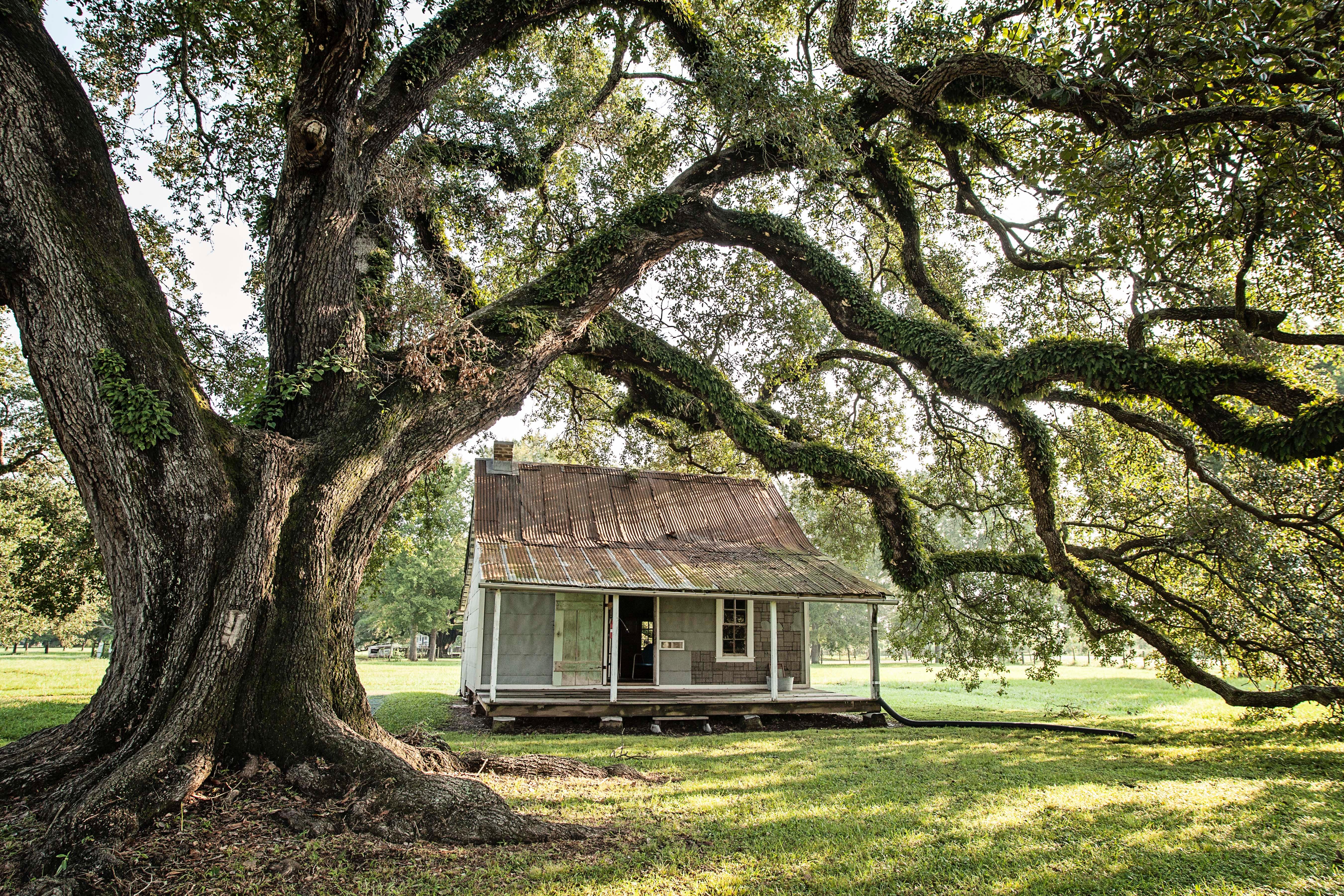
The Cane River region is home to a unique culture; the Creoles. Generations of the same families of workers, enslaved and tenant, and owners lived on these lands for over 200 years. The park tells the...

4 mi from route ~10 min detour Free near mile 239.9
View on nps.gov
New Orleans Jazz National Historical Park

New Orleans Jazz National Historical Park

National Historical Park

Discover the roots of jazz at the New Orleans Jazz National Historical Park. Located in the heart of the French Quarter, our park offers live performances, exhibits, and programs that celebrate the le...

5 mi from route ~13 min detour Free
View on nps.gov

Park data from the National Park Service API. Alerts update every 2 hours.

Fuel & Cost

Regular Gas

$50.03 one way

$100.07 round trip

$3.84/gal 25.4 MPG avg 116 kg CO2
Fuel Type $/gal One Way Round Trip
midgrade $4.21 $54.93 $109.85
premium $4.56 $59.46 $118.93
diesel $5.61 $73.15 $146.29

No toll roads detected on this route.

Estimated Trip Cost (one way, 1 person)

Fuel

$50

Meals

$25–$50

Total

$75–$100

Rough estimate based on US averages. Hotel $80–$140/night, meals $25–$50/day.

Estimated CO2 emission: 115.9 kg one way. Prices: EIA weekly data, 2026-04-13.

Driving Electric?

About $35 in charging · 1 stop · 66% less CO2

Vehicle Type kWh Stops DC Fast Home Charge
Average EV 99.4 1 $34.79 $15.90
Efficient EV 82.8 0 $28.99 $13.25
EV Truck/SUV 132.5 1 $46.38 $21.20

Gas CO2

116 kg

EV CO2

39 kg (66% less)

Plan for 1 charging stop. A 30-minute DC fast charge mid-route should be enough to complete the trip comfortably.

DC fast charging avg $0.35/kWh. Home charging avg $0.16/kWh. US grid CO2: 0.39 kg/kWh.

Travel Intel

Current conditions at both ends of the drive.

Forecast as of Apr 15, 2026

Origin

Metairie, LA

Afternoon in Metairie on Thursday

Local time

2:41 PM

CDT

Current temp

65°F

Unavailable

Live forecast

Destination

Eastwood, LA

Afternoon in Eastwood on Thursday

Local time

2:41 PM

CDT

Current temp

86°F

Unavailable

Live forecast

58°F

Alexandria, LA

166 mi in

Seasonal Notes

Summer travel usually means heavier construction, hotter rest stops, and busier weekend traffic around major cities.

Winter travel shortens daylight, so a route that looks manageable on paper can feel much longer after dark.

Holiday weekends tend to make both departure and arrival windows slower than the raw route time suggests.

Time zone

Same local time

Origin and destination are on the same clock, so arrival timing is easier to judge at a glance.

Temperature spread

21 degrees warmer at arrival

A meaningful temperature swing is a good cue to rethink layers, water, and how soon you want to arrive.

Road read

6h 12m on the road

Start early — leave by 6-7 AM to arrive at a reasonable hour.

Weather data from the National Weather Service. Conditions may change; check closer to your travel date.

Frequently Asked Questions

The drive from Metairie, LA to Eastwood, LA covers 331.3 miles and takes about 6h 12m without stops. Add 15-30 minutes for a fuel or rest stop on longer drives.
The main roads are Charles I. "Doc" Hudson Highway, I 10, State Route 1. Expect a mix of highway and local road driving.
This is a comfortable same-day trip.
The midpoint is about 165.6 miles from Metairie, LA. Look for rest areas, gas stations, or food options near the halfway mark.
At current regular gas prices, expect to spend about $50.03 one way. This estimate uses 25.4 MPG — your actual cost will vary with your vehicle's fuel efficiency and current gas prices.
Start early — leave by 6-7 AM to arrive at a reasonable hour. This is a long drive — plan for a morning departure or consider splitting it into two days.
Plan about 1 meaningful break for fuel, food, or rest. Plan on a short reset every 3 to 4 hours to stay fresh behind the wheel.
This is a demanding drive. With 20 significant decision points across 331.3 miles, you will need to stay alert - especially through interchange areas and urban stretches. Consider splitting it into segments if you are not comfortable with fast highway navigation.
The main spots that need attention: at 0.2 miles (North Causeway Boulevard): Complex interchange - multiple decisions in a short stretch; at 0.9 miles: Highway fork - watch signs carefully. Lane positioning matters here; at 74.4 miles (I 10): Highway fork - watch signs carefully. Lane positioning matters here.
The route from Metairie, LA to Eastwood, LA does not surface many named destination signs beyond the main corridor.
Yes. Nearby national parks include Cane River Creole National Historical Park and New Orleans Jazz National Historical Park.

Was this helpful?

Thanks for your feedback!

Your tip has been submitted. Thanks!

/500

Explore More

Explore more options from Metairie, LA or browse trips ending in Eastwood, LA.

Looking for more statewide routes? Browse LA road trips.

Explore maps for Metairie, LA or Eastwood, LA on MapSof.net.