The drive from Milton-Freewater, OR to Medford, OR covers 445.9 miles and takes about 9h 47m behind the wheel.
It usually feels better as a 2-day road trip than as one long push.
The route leans on The Dalles-California Highway, Sherman Highway, Columbia River Highway for much of the mileage,
and the overall profile is turn-heavy local drive.
The longest uninterrupted segment is about 121.9 miles on The Dalles-California Highway.
At current regular gas prices, budget about $88.83 one way before food or hotel costs.
Trip Pace
Best split across 2 days
Treat the return leg as its own travel day rather than an afterthought.
Break Rhythm
2 planned breaks
Plan on a short reset every 3 to 4 hours to stay fresh behind the wheel.
Midpoint
223 miles from Milton-Freewater, OR
A natural place for your longest stop of the day
, about 4h 30m into the drive
.
Who Is This Route For?
Solo Traveler
9h 47m drive, plan rest stops for pacing.
Scenic Drive
Turn-heavy local drive route profile with national parks nearby.
Drive Character
Expect a 9h 47m drive with frequent turns across 445.9 miles of local and secondary roads.
This route has more turning and local-road decision points than a simple highway run.
There are about 56 navigation steps in the underlying route data, so the final approach matters more than the middle miles.
The Dalles-California Highway is the longest continuous segment at about 121.9 miles.
Elevation Profile
High-altitude sections with notable climbs
4,663 ft292 ft
Total Climb
5,307 ft
Total Descent
4,969 ft
Highest Point
4,663 ft
~350.4 mi in
Elevation Range
4,371 ft
Notable High Points
3,344 ft at ~191.1 miles+936 ft prominence
4,663 ft at ~350.4 miles+214 ft prominence
How Hard Is This Drive?
Expect a hands-on drive with frequent turns and local roads rather than long highway stretches. This route has several spots where lane changes, forks, or exits need your full attention. The trickiest moment comes around 28.3 miles in near OR 11 / Oregon-Washington Highway.
Driving Effort8/10
Demanding - plan breaks and stay ahead of the key maneuvers
Balances navigation complexity with total wheel time.
This is a demanding drive. With 28 significant decision points across 445.9 miles, you will need to stay alert - especially through interchange areas and urban stretches. Consider splitting it into segments if you are not comfortable with fast highway navigation.
Where does it get tricky?
The main spots that need attention: at 28.3 miles (OR 11 / Oregon-Washington Highway): Lane positioning matters here; at 135.3 miles: Exit ramp - move to the correct lane early. Multiple destination signs - pick the right one; at 228.5 miles (US 26; US 97 / 4th Street): Lane positioning matters here.
Critical Maneuvers
5 of 28 key points
These are the spots where you need to pay the most attention. Preview them before you drive.
5
28.3 mi into trip|~41m in|OR 11 / Oregon-Washington Highway
Turn left onto OR 11 / Oregon-Washington Highway
Lane positioning matters here
Use the left lane.
5
135.3 mi into trip|~2h 37m in
Take the exit toward US 97: Yakima, Bend
Exit ramp - move to the correct lane early. Multiple destination signs - pick the right one
Toward US 97: Yakima, Bend
5
228.5 mi into trip|~4h 37m in|US 26; US 97 / 4th Street
Turn left onto US 26; US 97 / 4th Street
Lane positioning matters here
Use the left / straight / right lanes.
5
255.7 mi into trip|~5h 18m in|Southwest Canal Boulevard
Turn left onto Southwest Canal Boulevard
Lane positioning matters here
Use the left lane.
6
256 mi into trip|~5h 19m in|Southwest Canal Boulevard
Enter roundabout onto Southwest Canal Boulevard
Roundabout - know your exit number before entering
Towns Mentioned on Route Signs
Based on OSRM destination-sign hints, not a full list of every settlement the road passes.
On the drive from Milton-Freewater, OR to Medford, OR, road signs begin pointing toward Bend along the way.
Bend
135.3 mi in|~2h 37m
Main Roads
Road
Distance
Duration
The Dalles-California Highway
121.9 mi
2h 35m
Sherman Highway
67.7 mi
1h 29m
Columbia River Highway
62.9 mi
1h 7m
Crater Lake Highway
49.9 mi
1h 12m
Old Oregon Trail Highway
43 mi
46m
Diamond Lake Highway
23.8 mi
35m
Oregon-Washington Highway
15.3 mi
21m
New Oregon-Washington Highway
12.3 mi
17m
Longest stretch:
The Dalles-California Highway
— 121.9 mi, about 2h 35m
Turn-by-Turn Driving Directions
Step-by-step road directions between Milton-Freewater, OR and Medford, OR.
1
Start on OR 11
0.7 mi·2 min·South Main Street
2
Turn straight onto OR 11
15 mi·20 min·Oregon-Washington Highway
3
Continue on OR 11
12 mi·17 min·New Oregon-Washington Highway
4
Keep slight left at fork onto OR 11
226 ft·3 sec·New Oregon-Washington Highway
5
Continue on US 30; OR 11
0.7 mi·1 min·Southeast Court Avenue
6
Turn left onto OR 11
0.8 mi·1 min·Oregon-Washington Highway
Use the left lane.
7
Take the ramp
0.3 mi·42 sec
8
Merge onto I 84
43 mi·46 min·Old Oregon Trail Highway
9
Continue on I 84; US 30
63 mi·1 hr 7 min·Columbia River Highway
10
Take the exit
0.2 mi·37 sec
Toward US 97: Yakima, Bend
11
Turn left onto US 97
55 mi·1 hr 12 min·Sherman Highway
12
Continue on US 97
0.4 mi·52 sec·E Street
13
Turn straight onto US 97
12 mi·16 min·Sherman Highway
14
Continue on US 97
25 mi·29 min·The Dalles-California Highway
15
Continue on US 97
0.2 mi·32 sec·Northeast 6th Street
16
Turn left onto US 26; US 97
264 ft·12 sec·4th Street
Use the left / straight / right lanes.
17
Continue on US 26; US 97
1.0 mi·3 min·Southwest 4th Street
18
Continue on US 26; US 97
26 mi·37 min·The Dalles-California Highway
19
Turn right onto US 97 Business
503 ft·14 sec·Southwest Veterans Way
20
Turn left onto Southwest Canal Boulevard
0.3 mi·47 sec·Southwest Canal Boulevard
Use the left lane.
21
Enter roundabout onto Southwest Canal Boulevard
60 ft·1 sec·Southwest Canal Boulevard
22
Continue on Southwest Canal Boulevard
1.4 mi·3 min·Southwest Canal Boulevard
23
Enter roundabout onto Southwest Canal Boulevard
112 ft·2 sec·Southwest Canal Boulevard
24
Continue on Southwest Canal Boulevard
0.8 mi·1 min·Southwest Canal Boulevard
25
Enter roundabout onto Southwest Canal Boulevard
125 ft·2 sec·Southwest Canal Boulevard
26
Continue on Southwest Canal Boulevard
3.8 mi·6 min·Southwest Canal Boulevard
27
Continue on Old Bend Redmond Highway
3.5 mi·6 min·Old Bend Redmond Highway
28
Enter roundabout onto Old Bend Redmond Highway
121 ft·2 sec·Old Bend Redmond Highway
29
Continue on Old Bend Redmond Highway
3.1 mi·5 min·Old Bend Redmond Highway
30
Enter roundabout onto US 20
276 ft·3 sec·McKenzie-Bend Highway
31
Continue on US 20
0.7 mi·1 min·McKenzie-Bend Highway
32
Enter roundabout onto US 20
130 ft·1 sec·McKenzie-Bend Highway
33
Continue on US 20
0.4 mi·36 sec·McKenzie-Bend Highway
34
Enter roundabout onto US 20
118 ft·1 sec·McKenzie-Bend Highway
35
Continue on US 20
0.8 mi·57 sec·McKenzie-Bend Highway
36
Turn straight onto US 20; US 97 Business
439 ft·13 sec·Northeast 3rd Street
37
Turn left onto Empire Avenue
0.2 mi·20 sec·Empire Avenue
38
Take the exit
0.3 mi·32 sec
39
Merge onto US 97
5.5 mi·9 min·Bend Parkway
Use the straight / slight right lanes.
40
Continue on US 97
71 mi·1 hr 28 min·The Dalles-California Highway
41
Turn right onto OR 138
6.3 mi·8 min·State Highway 138
42
Continue on OR 138
8.4 mi·11 min·East Diamond Lake Highway
43
Continue on OR 138
3.0 mi·4 min·North Umpqua Highway
44
Turn left onto OR 230
24 mi·35 min·Diamond Lake Highway
45
Continue on Crater Lake Highway
50 mi·1 hr 11 min·Crater Lake Highway
Use the straight lane.
46
Turn right onto OR 62
4.4 mi·6 min·Rogue Valley Expressway
47
Continue on OR 62
0.4 mi·39 sec·Crater Lake Highway
48
Turn left onto Poplar Drive
0.9 mi·1 min·Poplar Drive
Use the left lane.
49
Turn right onto East McAndrews Road
0.2 mi·20 sec·East McAndrews Road
50
Turn left onto Biddle Road
512 ft·18 sec·Biddle Road
Use the left / straight lanes.
51
Keep slight right at fork onto Biddle Road
0.1 mi·13 sec·Biddle Road
52
Keep slight right at fork onto Biddle Road
0.2 mi·21 sec·Biddle Road
53
Keep slight right at fork onto Biddle Road
0.3 mi·29 sec·Biddle Road
54
Continue on East 4th Street
0.4 mi·56 sec·East 4th Street
Use the straight / right lanes.
55
Turn left onto North Fir Street
0.1 mi·15 sec·North Fir Street
56
Arrive at destination
North Fir Street
Trip Plan
Morning Departure
Start early — leave by 6-7 AM to arrive at a reasonable hour.
Evening Departure
This is a long drive — plan for a morning departure or consider splitting it into two days.
This drive is better paced as a 2-day trip.
Plan roughly 2 meaningful breaks for fuel, food, and rest.
The halfway point lands around 223 miles from Milton-Freewater, OR, or about 4h 30m into the drive.
The longest continuous stretch on this route runs about 121.9 miles.
Consider an overnight stop or starting very early.
Departure
Before you leave
Start with fuel, water, and navigation already sorted so the first hour feels easy.
First stop
Around 98 miles or 1h 57m in
Use this first pause for coffee, a restroom break, and a quick traffic check ahead.
Halfway reset
Around 223 miles or 4h 30m in
This is the best place for your longest stop, a real meal, and a full fuel check.
Overnight split
Day 1 wrap after about 223 miles or 4h 30m
Stop before fatigue turns the last few hours into a grind. You want day two to start fresh, not just resumed.
Final approach
Final hour starts around 8h 19m
Traffic, exits, and arrival timing usually matter more near Medford, OR than in the middle of the route.
Before You Leave
+
Open the route before leaving Milton-Freewater, OR so your first major turns are already loaded.
+
Leave with enough water and a charging cable within reach, not packed away.
+
Check your fuel range against the first long segment, especially if you are starting outside city service areas.
+
Pick one backup stop option before the midpoint in case traffic changes your pacing.
+
Treat this as a 2-day road trip and book the overnight stop before the busiest arrival window.
Day 1
Settle into the route from Milton-Freewater, OR
Aim for roughly 223 miles and 4.9 hours of wheel time on this day.
Day 2
Finish the approach into Medford, OR
Aim for roughly 223 miles and 4.9 hours of wheel time on this day.
Your first comfortable stop window is around 98 miles from Milton-Freewater, OR.
This route usually feels better as a 2-day drive than as one long push.
Plan about 2 real breaks rather than only quick fuel stops.
The longest stretch is on The Dalles-California Highway for about 121.9 miles.
Where to Stop
Rest stops, refuel points, and overnight suggestions along this route.
Halfway Point
Midpoint
About 223 mi from Milton-Freewater, OR
· 4h 30m into the drive
The midpoint is around 223 miles from Milton-Freewater, OR, which is a good place for a longer meal and fuel stop.
Before the longest stretch
Fuel check
Top up before The Dalles-California Highway if your tank is already low. That segment runs about 121.9 miles.
Overnight split
Hotel stop
For a steadier pace, wrap day one after about 223 miles or 4.9 hours on the road.
Arriving in Medford, OR
The final approach into Medford, OR usually feels slower than the middle of the drive, so avoid planning your tightest schedule at the very end.
Try to arrive with enough fuel left to skip an immediate station stop unless you already know the area around Medford, OR.
On a multi-day trip, keep the last day a little lighter so you reach Medford, OR with some flexibility left in the schedule.
After long uninterrupted mileage, take five minutes before the last urban segment to reset and refocus on exits, merges, and city traffic.
These stop ideas are pacing suggestions — the exact town or exit can change with traffic, hotel plans, and fuel range.
National Parks Near This Route
Worth a detour if your schedule allows.
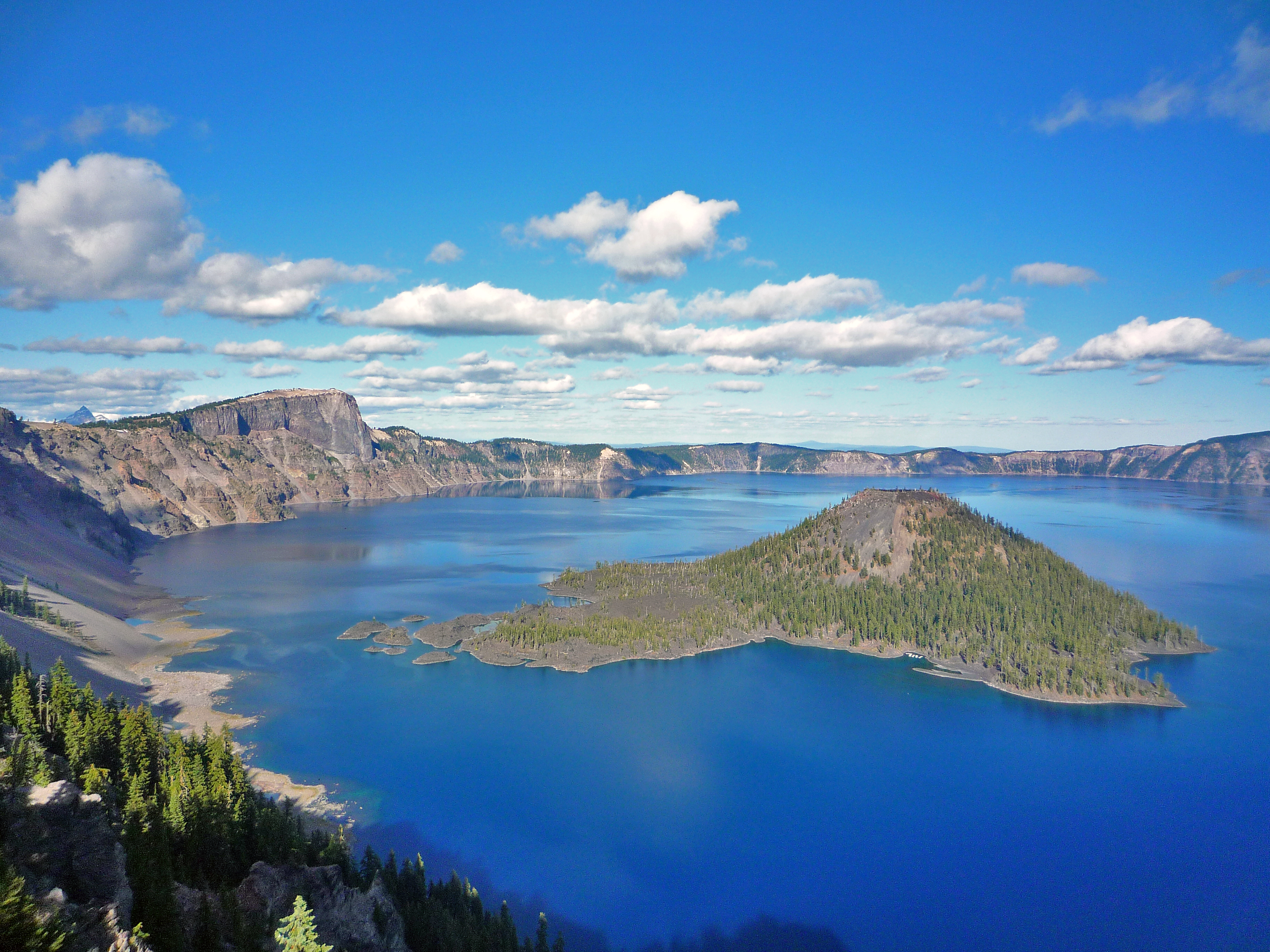
Crater Lake National Park
National Park
Crater Lake inspires awe. Native Americans witnessed its formation 7,700 years ago, when a violent eruption triggered the collapse of a tall peak. Scientists marvel at its purity—fed by rain and snow,...
11 mi from route
~29 min detour
$30
near mile 369
Park Closure: Road to Rim Village is Temporarily CLOSED Due to Incoming Snowstorm
Park Closure: Cleetwood Cove Trail is CLOSED for Rehabilitation
Park data from the National Park Service API. Alerts update every 2 hours.
Fuel & Cost
Regular Gas
$88.83 one way
$177.66 round trip
$5.06/gal25.4 MPG avg156 kg CO2
Fuel Type
$/gal
One Way
Round Trip
midgrade
$5.36
$94.01
$188.02
premium
$5.59
$98.15
$196.30
diesel
$5.61
$98.45
$196.90
No toll roads detected on this route.
Estimated Trip Cost (one way, 1 person)
Fuel
$89
Hotel (1n)
$80–$140
Meals
$50–$100
Total
$219–$329
Rough estimate based on US averages. Hotel $80–$140/night, meals $25–$50/day.
Estimated CO2 emission: 156 kg one way.
Prices: EIA weekly data, 2026-04-13.
Driving Electric?
About $47 in charging
· 1 stop
· 67% less CO2
Vehicle Type
kWh
Stops
DC Fast
Home Charge
Average EV
133.8
1
$46.82
$21.40
Efficient EV
111.5
1
$39.02
$17.84
EV Truck/SUV
178.4
2
$62.43
$28.54
Gas CO2
156 kg
EV CO2
52 kg (67% less)
Plan for 1 charging stop. A 30-minute DC fast charge mid-route should be enough to complete the trip comfortably.
DC fast charging avg $0.35/kWh. Home charging avg $0.16/kWh. US grid CO2: 0.39 kg/kWh.
Travel Intel
Current conditions at both ends of the drive.
Forecast as of Apr 15, 2026
Origin
Milton-Freewater, OR
Late night
in Milton-Freewater on Saturday
Local time
4:38 AM
PDT
Current temp
48°F
Unavailable
Live forecast
Destination
Medford, OR
Late night
in Medford on Saturday
Local time
4:38 AM
PDT
Current temp
55°F
Unavailable
Live forecast
Seasonal Notes
Summer travel usually means heavier construction, hotter rest stops, and busier weekend traffic around major cities.
Winter travel shortens daylight, so a route that looks manageable on paper can feel much longer after dark.
Holiday weekends tend to make both departure and arrival windows slower than the raw route time suggests.
For long drives, weather on day two can matter just as much as conditions at departure, so check the whole travel window rather than only the first day.
Time zone
Same local time
Origin and destination are on the same clock, so arrival timing is easier to judge at a glance.
Temperature spread
7 degrees warmer at arrival
A meaningful temperature swing is a good cue to rethink layers, water, and how soon you want to arrive.
Road read
9h 47m on the road
This is long enough that the arrival forecast matters almost as much as departure conditions. Recheck both ends before you roll.
Weather data from the National Weather Service. Conditions may change; check closer to your travel date.
Frequently Asked Questions
The drive from Milton-Freewater, OR to Medford, OR covers 445.9 miles and takes about 9h 47m without stops. Add 15-30 minutes for a fuel or rest stop on longer drives.
The main roads are The Dalles-California Highway, Sherman Highway, Columbia River Highway. Expect a mix of highway and local road driving.
Consider an overnight stop or starting very early.
Yes. This route is usually more comfortable as a 2-day drive. A sensible stopping point is after roughly 223 miles on day one.
The midpoint is about 223 miles from Milton-Freewater, OR. Look for rest areas, gas stations, or food options near the halfway mark.
At current regular gas prices, expect to spend about $88.83 one way. This estimate uses 25.4 MPG — your actual cost will vary with your vehicle's fuel efficiency and current gas prices.
Start early — leave by 6-7 AM to arrive at a reasonable hour. This is a long drive — plan for a morning departure or consider splitting it into two days.
Plan about 2 meaningful breaks for fuel, food, or rest. Plan on a short reset every 3 to 4 hours to stay fresh behind the wheel.
This is a demanding drive. With 28 significant decision points across 445.9 miles, you will need to stay alert - especially through interchange areas and urban stretches. Consider splitting it into segments if you are not comfortable with fast highway navigation.
The main spots that need attention: at 28.3 miles (OR 11 / Oregon-Washington Highway): Lane positioning matters here; at 135.3 miles: Exit ramp - move to the correct lane early. Multiple destination signs - pick the right one; at 228.5 miles (US 26; US 97 / 4th Street): Lane positioning matters here.
On the drive from Milton-Freewater, OR to Medford, OR, road signs begin pointing toward Bend along the way.
High-altitude sections with notable climbs. The route ranges from 292 ft to 4,663 ft elevation with about 5,307 ft of total climbing. There are 2 notable high points along the way.
Yes. Nearby national parks include Crater Lake National Park.