Origin
Missoula, MT
Afternoon in Missoula on Saturday
Local time
2:56 PM
MDT
Current temp
65°F
Unavailable
Live forecast
Compiled and reviewed by the US Trip Planner planning team at COD Solutions Oy · Last reviewed Apr 18, 2026 · Editorial standards
Drive Time
6h 35m
Distance
402.7 mi
648 km
Drive Score
9/10
Great drive
Same Day?
Yes, doable
Fuel Cost
$64
one way
EV Charging
Unknown
Estimated drive times based on typical traffic patterns. Actual times may vary with weather, construction, and real-time conditions.

Missoula, MT
Wikimedia Commons

Crow Agency, MT
Wikimedia Commons
The drive from Missoula, MT to Crow Agency, MT covers 402.7 miles and takes about 6h 35m behind the wheel. This route is realistic as a one-day drive if you keep your stops efficient.
The route leans on I 90, Jeannette Rankin Memorial Highway, I 15 for much of the mileage, and the overall profile is mostly highway. The longest uninterrupted segment is about 175.4 miles on I 90. At current regular gas prices, budget about $63.81 one way before food or hotel costs.
Trip Pace
Same-day drive is realistic
A same-day return is possible, but it will make for a full day on the road.
Break Rhythm
1 planned break
Plan on a short reset every 3 to 4 hours to stay fresh behind the wheel.
Midpoint
201.3 miles from Missoula, MT
A natural place for your longest stop of the day , about 3h 16m into the drive .
| Road | Distance | Duration |
|---|---|---|
| I 90 | 175.4 mi | 2h 52m |
| Jeannette Rankin Memorial Highway | 115.1 mi | 1h 49m |
| I 15 | 110.8 mi | 1h 51m |
| East Broadway Street | 0.6 mi | <1m |
| I 90 Business | 0.2 mi | <1m |
| Van Buren Street | <0.1 mi | <1m |
| North Higgins Avenue | <0.1 mi | <1m |
| Makawasha Avenue | — | — |
Some road-level metrics are being recalculated.
Step-by-step road directions between Missoula, MT and Crow Agency, MT.
Start on North Higgins Avenue
Turn left onto I 90 Bus; US 12 Bus
Turn left onto I 90 Bus; US 12
Take the exit onto I 90 Business; US 12
Merge onto I 90; US 12; MT 200
Keep slight right at fork onto I 15; I 90
Continue on I 90; US 89; US 191
Continue on I 90; US 191
Continue on I 90; US 87; US 212
Keep slight right at fork onto I 90; US 87; US 212
Take the exit
Turn left
Arrive at destination
Morning Departure
Start early — leave by 6-7 AM to arrive at a reasonable hour.
Evening Departure
This is a long drive — plan for a morning departure or consider splitting it into two days.
This is a comfortable same-day trip.
Departure
Before you leave
Start with fuel, water, and navigation already sorted so the first hour feels easy.
First stop
Around 89 miles or 1h 25m in
Use this first pause for coffee, a restroom break, and a quick traffic check ahead.
Halfway reset
Around 201.3 miles or 3h 16m in
This is the best place for your longest stop, a real meal, and a full fuel check.
Final approach
Final hour starts around 5h 37m
Traffic, exits, and arrival timing usually matter more near Crow Agency, MT than in the middle of the route.
Open the route before leaving Missoula, MT so your first major turns are already loaded.
Leave with enough water and a charging cable within reach, not packed away.
Check your fuel range against the first long segment, especially if you are starting outside city service areas.
Day 1
Settle into the route from Missoula, MT
This is one driving day of about 402.7 miles and 6h 35m.
Rest stops, refuel points, and overnight suggestions along this route.

Mid-route town
Meal stop
201 mi into the route
Best for: Lunch, fuel, and a longer reset
This sits close to the middle of the route, so it works well for the longest stop of the day.
A short stop after about 89 miles helps settle the day before fatigue starts building.
The midpoint is around 201.3 miles from Missoula, MT, which is a good place for a longer meal and fuel stop.
Before the longest stretch
Fuel checkTop up before I 90 if your tank is already low. That segment runs about 175.4 miles.
These stop ideas are pacing suggestions — the exact town or exit can change with traffic, hotel plans, and fuel range.
5 decision points cluster between mile 0 and 402.2 — GPS handles the exact turns, but know they're coming. Your lane choice matters more than the turn itself.
Turn left onto I 90 Bus; US 12 Bus / East Broadway Street
Navigation decision point
Take the exit onto I 90 Business; US 12
Exit ramp - move to the correct lane early
Keep slight right at fork onto I 15; I 90
Highway fork - watch signs carefully. Lane positioning matters here
Keep slight right at fork onto I 90; US 87; US 212 toward I 90 East: Sheridan
Highway fork - watch signs carefully
Take the exit toward Crow Agency, Baaxuwuaashe
Exit ramp - move to the correct lane early. Multiple destination signs - pick the right one
Regular Gas
$63.81 one way
$127.63 round trip
| Fuel Type | $/gal | One Way | Round Trip |
|---|---|---|---|
| midgrade | $4.22 | $66.89 | $133.78 |
| premium | $4.53 | $71.84 | $143.67 |
| diesel | $5.61 | $88.91 | $177.82 |
No toll roads detected on this route.
Estimated Trip Cost (one way, 1 person)
Fuel
$64
Meals
$25–$50
Total
$89–$114
Rough estimate based on US averages. Hotel $80–$140/night, meals $25–$50/day.
Estimated CO2 emission: 140.9 kg one way. Prices: EIA weekly data, 2026-04-13.
Driving Electric?
About $42 in charging · 1 stop · 67% less CO2
| Vehicle Type | kWh | Stops | DC Fast | Home Charge |
|---|---|---|---|---|
| Average EV | 120.8 | 1 | $42.28 | $19.33 |
| Efficient EV | 100.7 | 1 | $35.24 | $16.11 |
| EV Truck/SUV | 161.1 | 2 | $56.38 | $25.77 |
Gas CO2
141 kg
EV CO2
47 kg (67% less)
Plan for 1 charging stop. A 30-minute DC fast charge mid-route should be enough to complete the trip comfortably.
DC fast charging avg $0.35/kWh. Home charging avg $0.16/kWh. US grid CO2: 0.39 kg/kWh.
Current conditions at both ends of the drive.
Origin
Afternoon in Missoula on Saturday
Local time
2:56 PM
MDT
Current temp
65°F
Unavailable
Destination
Afternoon in Crow Agency on Saturday
Local time
2:56 PM
MDT
Current temp
45°F
Unavailable
74°F
Whitehall, MT
201 mi in
Seasonal Notes
Summer travel usually means heavier construction, hotter rest stops, and busier weekend traffic around major cities.
Winter travel shortens daylight, so a route that looks manageable on paper can feel much longer after dark.
Holiday weekends tend to make both departure and arrival windows slower than the raw route time suggests.
Time zone
Origin and destination are on the same clock, so arrival timing is easier to judge at a glance.
Temperature spread
A meaningful temperature swing is a good cue to rethink layers, water, and how soon you want to arrive.
Road read
Start early — leave by 6-7 AM to arrive at a reasonable hour.
Weather data from the National Weather Service. Conditions may change; check closer to your travel date.
Worth a detour if your schedule allows.
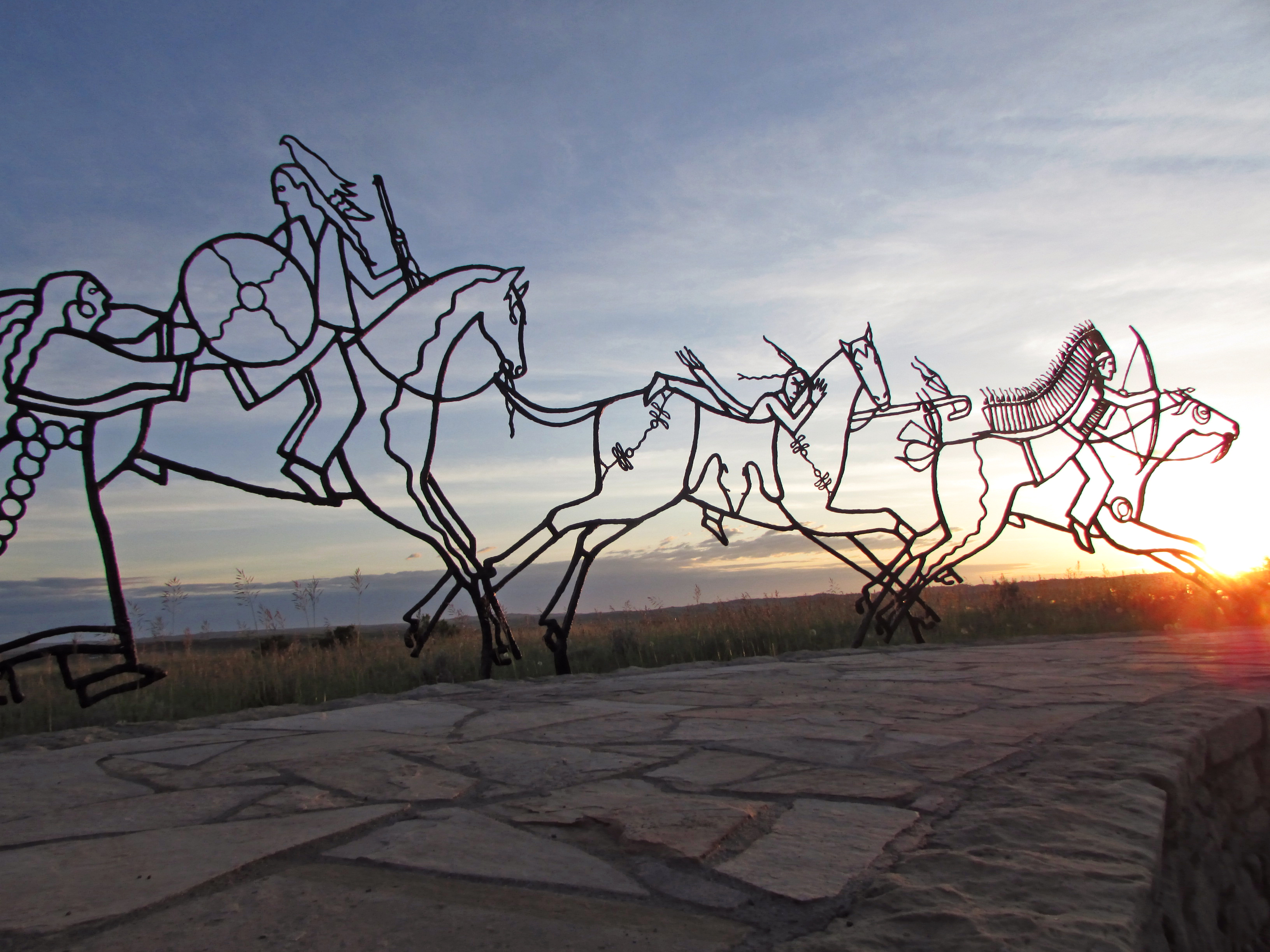
National Monument
This land is a place to honor and reflect on the sacrifices made here on June 25 and 26, 1876, when Lakota, Cheyenne, and Arapaho warriors fought against a deliberate attack by the U.S. Army's 7th Cav...
Park data from the National Park Service API. Alerts update every 2 hours.
402.7 mi in 6h 35m, mostly highway — 175.4 mi of that is on I 90.
This is a straightforward highway drive that stays mostly on I 90 and Jeannette Rankin Memorial Highway. There are only a few real navigation decisions along the way. The trickiest moment comes early in the drive near I 90 Bus; US 12 Bus / East Broadway Street.
Easy - simple navigation with a manageable amount of wheel time
Balances navigation complexity with total wheel time.
The route itself is not hard, but at 6h 35m, endurance matters. Plan breaks every 2-3 hours. The 8 decision points are all manageable with basic attention.
Where does it get tricky?
The main spots that need attention: near the start (I 90 Bus; US 12 Bus / East Broadway Street): Navigation decision point; at 0.7 miles (I 90 Business; US 12): Exit ramp - move to the correct lane early; at 116 miles (I 15; I 90): Highway fork - watch signs carefully. Lane positioning matters here.
Weekend Trip
Doable as a same-day drive at 6h 35m. Total distance: 402.7 miles.
Family Friendly
Moderate complexity with 1 natural rest stops along the way.
Solo Traveler
6h 35m drive, plan rest stops for pacing.
First-Time Driver
Mostly highway driving (71%). Straightforward navigation.
Compiled by the US Trip Planner planning team at COD Solutions Oy from open government datasets — OSRM over OpenStreetMap for geometry, EIA for fuel prices, and NPS for national parks. See our methodology for refresh cadence and limitations.
Was this helpful?
Thanks for your feedback!
Your tip has been submitted. Thanks!
/500
Recent Tips
·
Explore more options from Missoula, MT or browse trips ending in Crow Agency, MT.
Looking for more statewide routes? Browse MT road trips.