
Trip from Moorcroft, WY to Laramie, WY

Last recalculated Apr 16, 2026

Drive Time

5h 11m

Distance

274.8 mi

442 km

Drive Score

8/10

Great drive

Same Day?

Yes, doable

Fuel Cost

$44

one way

EV Charging

Unknown

Best Time to Leave

Save up to 40 min
4 AM
4h 58m ★
6 AM
5h 12m
8 AM
5h 38m
10 AM
5h 21m
12 PM
5h 18m
3 PM
5h 22m
5 PM
5h 37m
8 PM
5h 3m

Estimated drive times based on typical traffic patterns. Actual times may vary with weather, construction, and real-time conditions.

Downtown Moorcroft, WY, WY

Moorcroft, WY

David Pickup | Advertising & Marketing 🇬🇧

city in and county seat of Albany County, Wyoming, United States

Laramie, WY

Wikimedia Commons

Trip Overview

The drive from Moorcroft, WY to Laramie, WY covers 274.8 miles and takes about 5h 11m behind the wheel. This route is realistic as a one-day drive if you keep your stops efficient.

The route leans on State Highway 59 South, I 25, State Highway 34 for much of the mileage, and the overall profile is highway-focused drive. The longest uninterrupted segment is about 106.6 miles on State Highway 59 South. At current regular gas prices, budget about $43.55 one way before food or hotel costs.

Trip Pace

Same-day drive is realistic

A same-day return is possible, but it will make for a full day on the road.

Break Rhythm

1 planned break

Plan on a short reset every 3 to 4 hours to stay fresh behind the wheel.

Midpoint

137.4 miles from Moorcroft, WY

A natural place for your longest stop of the day , about 2h 30m into the drive .

Who Is This Route For?

Weekend Trip

Doable as a same-day drive at 5h 11m. Total distance: 274.8 miles.

Family Friendly

Moderate complexity with 1 natural rest stops along the way.

Solo Traveler

5h 11m drive, comfortable solo distance.

First-Time Driver

Mostly highway driving (95%). Straightforward navigation.

Drive Character

This is a 5h 11m highway drive covering 274.8 miles, with most of the trip on State Highway 59 South and I 25. The longest continuous stretch is about 106.6 miles on State Highway 59 South.

Most of the miles stay on highways, which makes pacing and fuel planning easier than turn-by-turn city driving.
There are about 25 navigation steps in the underlying route data, so the final approach matters more than the middle miles.
State Highway 59 South is the longest continuous segment at about 106.6 miles.

How Hard Is This Drive?

This is a straightforward highway drive that stays mostly on State Highway 59 South and I 25. There are only a few real navigation decisions along the way. The trickiest moment comes around 25.3 miles in near I 90; US 14; US 16.

Driving Effort 3/10

Easy - simple navigation with a manageable amount of wheel time

Balances navigation complexity with total wheel time.

This is a straightforward 5h 11m drive. You will face about 18 decision points, but nothing that requires special attention if you follow navigation.

Where does it get tricky?

The main spots that need attention: at 25.3 miles (I 90; US 14; US 16): Exit ramp - move to the correct lane early; at 142.9 miles (I 25 BUS; US 20 BUS; US 26 BUS; US 87 BUS): Multiple destination signs - pick the right one; at 142.9 miles (I 25 BUS; US 20 BUS; US 26 BUS; US 87 BUS): Highway fork - watch signs carefully. Multiple destination signs - pick the right one.

Critical Maneuvers

5 of 18 key points

These are the spots where you need to pay the most attention. Preview them before you drive.

5
25.3 mi into trip | ~25m in | I 90; US 14; US 16

Take the exit onto I 90; US 14; US 16 toward Garner Lake Road

Exit ramp - move to the correct lane early

Exit 129 Toward Garner Lake Road
6
142.9 mi into trip | ~2h 39m in | I 25 BUS; US 20 BUS; US 26 BUS; US 87 BUS

Take the ramp onto I 25 BUS; US 20 BUS; US 26 BUS; US 87 BUS toward I 25, US 20, US 26, US 87

Multiple destination signs - pick the right one

Toward I 25, US 20, US 26, US 87
6
142.9 mi into trip | ~2h 39m in | I 25 BUS; US 20 BUS; US 26 BUS; US 87 BUS

Keep slight left at fork onto I 25 BUS; US 20 BUS; US 26 BUS; US 87 BUS toward I 25, US 20, US 26, US 87

Highway fork - watch signs carefully. Multiple destination signs - pick the right one

Toward I 25, US 20, US 26, US 87
5
274.8 mi into trip | ~5h 11m in | South 5th Street

Turn right onto South 5th Street

Navigation decision point

5
274.8 mi into trip | ~5h 11m in

Turn right

Navigation decision point

Towns Mentioned on Route Signs

Based on OSRM destination-sign hints, not a full list of every settlement the road passes.

On the drive from Moorcroft, WY to Laramie, WY, road signs begin pointing toward Cheyenne along the way.

Cheyenne

185.9 mi in | ~3h 21m | via I 25; US 87

Main Roads

Road Distance Duration
State Highway 59 South 106.6 mi 1h 56m
I 25 61.9 mi 59m
State Highway 34 51.6 mi 1h 4m
I 90 24.4 mi 24m
US Highway 30 14.4 mi 20m
North Garner Lake Road 4.2 mi 6m
North 4th Street 2.9 mi 5m
East Richards Street 2.4 mi 3m
Longest stretch: State Highway 59 South — 106.6 mi, about 1h 56m

Turn-by-Turn Driving Directions

Step-by-step road directions between Moorcroft, WY and Laramie, WY.

1

Start on South Yellowstone Avenue

82 ft · 7 sec · South Yellowstone Avenue
2

Turn left onto I 90 Business; US 14; US 16

1.2 mi · 1 min · East Converse Street
3

Take the ramp onto I 90

24 mi · 23 min · I 90
4

Take the exit onto I 90; US 14; US 16

0.4 mi · 49 sec · I 90; US 14; US 16
Exit 129 Toward Garner Lake Road
5

Turn left onto North Garner Lake Road

4.2 mi · 6 min · North Garner Lake Road
6

Turn left onto WY 59

1.7 mi · 2 min · South Douglas Highway
7

Continue on WY 59

107 mi · 1 hr 56 min · State Highway 59 South
8

Turn left onto Wyoming Highway 59 Connector

0.4 mi · 44 sec · Wyoming Highway 59 Connector
9

Turn straight onto North 4th Street

1.9 mi · 3 min · North 4th Street
10

Turn left onto I 25 BUS; US 20 BUS; US 26 BUS; US 87 BUS

2.4 mi · 3 min · East Richards Street
11

Take the ramp onto I 25 BUS; US 20 BUS; US 26 BUS; US 87 BUS

380 ft · 9 sec · I 25 BUS; US 20 BUS; US 26 BUS; US 87 BUS
Toward I 25, US 20, US 26, US 87
12

Keep slight left at fork onto I 25 BUS; US 20 BUS; US 26 BUS; US 87 BUS

0.7 mi · 1 min · I 25 BUS; US 20 BUS; US 26 BUS; US 87 BUS
Toward I 25, US 20, US 26, US 87
13

Merge onto I 25; US 20; US 26; US 87

8.2 mi · 8 min · I 25; US 20; US 26; US 87
14

Continue on I 25; US 26; US 87

34 mi · 31 min · I 25; US 26; US 87
15

Continue on I 25; US 87

19 mi · 17 min · I 25; US 87
Toward Cheyenne
16

Take the exit onto I 25

0.4 mi · 48 sec · I 25
Toward WY 34 West: Laramie
17

Turn right onto WY 34

52 mi · 1 hr 4 min · State Highway 34
18

At end of road, turn left onto US 30; US 287

14 mi · 20 min · US Highway 30
19

Continue on US 30; US 287

2.1 mi · 3 min · North 3rd Street
20

Turn left onto CR 322

411 ft · 13 sec · East Curtis Street
21

Turn right onto North 4th Street

1.0 mi · 2 min · North 4th Street
22

Turn left onto East Ivinson Avenue

363 ft · 12 sec · East Ivinson Avenue
23

Turn right onto South 5th Street

199 ft · 10 sec · South 5th Street
24

Turn right

45 ft · 3 sec
25

Arrive at destination

Trip Plan

Morning Departure

An early start around 7-8 AM gets you there with plenty of daylight left.

Evening Departure

A late afternoon start means arriving after dark. Morning is better.

You can normally do this drive in one day.
Plan roughly 1 meaningful break for fuel, food, and rest.
The halfway point lands around 137.4 miles from Moorcroft, WY, or about 2h 30m into the drive.
The longest continuous stretch on this route runs about 106.6 miles.

This is a comfortable same-day trip.

Departure

Before you leave

Start with fuel, water, and navigation already sorted so the first hour feels easy.

First stop

Around 60 miles or 1h 6m in

Use this first pause for coffee, a restroom break, and a quick traffic check ahead.

Halfway reset

Around 137.4 miles or 2h 30m in

This is the best place for your longest stop, a real meal, and a full fuel check.

Final approach

Final hour starts around 4h 5m

Traffic, exits, and arrival timing usually matter more near Laramie, WY than in the middle of the route.

Before You Leave

+

Open the route before leaving Moorcroft, WY so your first major turns are already loaded.

+

Leave with enough water and a charging cable within reach, not packed away.

+

Check your fuel range against the first long segment, especially if you are starting outside city service areas.

Day 1

Settle into the route from Moorcroft, WY

This is one driving day of about 274.8 miles and 5h 11m.

Your first comfortable stop window is around 60 miles from Moorcroft, WY.
This route can stay practical as a one-day drive if traffic stays reasonable.
Plan about 1 real break rather than only quick fuel stops.
The longest stretch is on State Highway 59 South for about 106.6 miles.

Where to Stop

Rest stops, refuel points, and overnight suggestions along this route.

Halfway Point

Midpoint

About 137.4 mi from Moorcroft, WY · 2h 30m into the drive

town in Wyoming, United States

Mid-route town

Meal stop

Wheatland, WY

137 mi into the route

Best for: Lunch, fuel, and a longer reset

This sits close to the middle of the route, so it works well for the longest stop of the day.

Pacing Suggestions

Wright, WY

Fuel and coffee

A short stop after about 80 miles helps settle the day before fatigue starts building.

Cheyenne, WY

Meal break

The midpoint is around 138.9 miles from Moorcroft, WY, which is a good place for a longer meal and fuel stop.

Arriving in Laramie, WY

The final approach into Laramie, WY usually feels slower than the middle of the drive, so avoid planning your tightest schedule at the very end.

Try to arrive with enough fuel left to skip an immediate station stop unless you already know the area around Laramie, WY.

After long uninterrupted mileage, take five minutes before the last urban segment to reset and refocus on exits, merges, and city traffic.

These stop ideas are pacing suggestions — the exact town or exit can change with traffic, hotel plans, and fuel range.

National Parks Near This Route

Worth a detour if your schedule allows.

Devils Tower National Monument

Devils Tower National Monument

National Monument

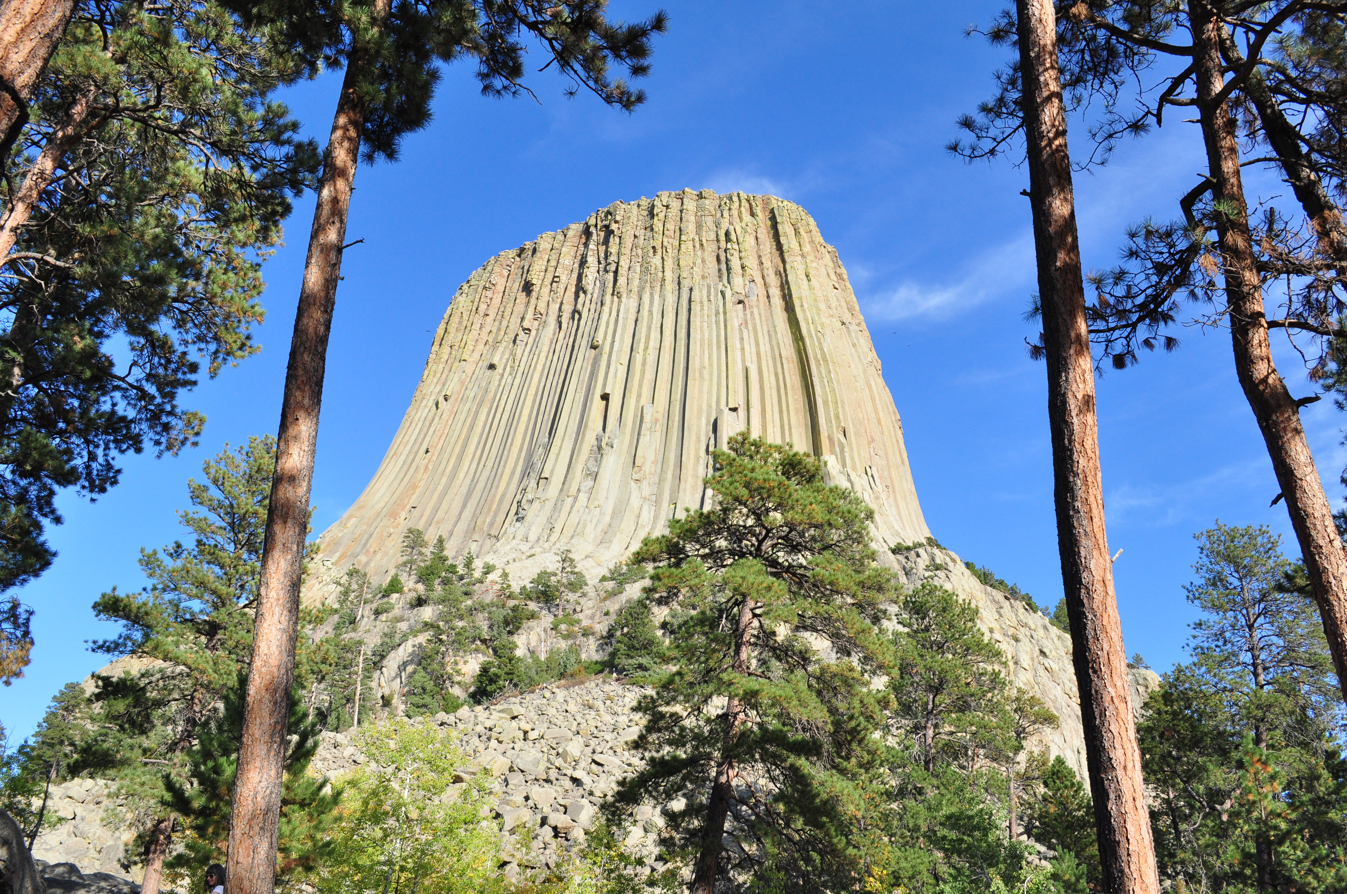
The Tower is an astounding geologic feature that protrudes out of the prairie surrounding the Black Hills. It is considered sacred by Northern Plains Indians and indigenous people. Hundreds of paralle...

25 mi from route ~64 min detour $25
Park Closure: The campground is closed for the season.
Danger: Stage 1 Burn Restrictions
View on nps.gov

Park data from the National Park Service API. Alerts update every 2 hours.

Fuel & Cost

Regular Gas

$43.55 one way

$87.09 round trip

$4.03/gal 25.4 MPG avg 96 kg CO2
Fuel Type $/gal One Way Round Trip
midgrade $4.22 $45.64 $91.29
premium $4.53 $49.02 $98.04
diesel $5.61 $60.67 $121.34

No toll roads detected on this route.

Estimated Trip Cost (one way, 1 person)

Fuel

$44

Meals

$25–$50

Total

$69–$94

Rough estimate based on US averages. Hotel $80–$140/night, meals $25–$50/day.

Estimated CO2 emission: 96.1 kg one way. Prices: EIA weekly data, 2026-04-13.

Driving Electric?

About $29 in charging · 1 stop · 67% less CO2

Vehicle Type kWh Stops DC Fast Home Charge
Average EV 82.4 1 $28.85 $13.19
Efficient EV 68.7 0 $24.04 $10.99
EV Truck/SUV 109.9 1 $38.47 $17.59

Gas CO2

96 kg

EV CO2

32 kg (67% less)

Plan for 1 charging stop. A 30-minute DC fast charge mid-route should be enough to complete the trip comfortably.

DC fast charging avg $0.35/kWh. Home charging avg $0.16/kWh. US grid CO2: 0.39 kg/kWh.

Travel Intel

Current conditions at both ends of the drive.

Forecast as of Apr 15, 2026

Origin

Moorcroft, WY

Afternoon in Moorcroft on Thursday

Local time

1:15 PM

MDT

Current temp

41°F

Unavailable

Live forecast

Destination

Laramie, WY

Afternoon in Laramie on Thursday

Local time

1:15 PM

MDT

Current temp

66°F

Unavailable

Live forecast

47°F

Wheatland, WY

137 mi in

Seasonal Notes

Summer travel usually means heavier construction, hotter rest stops, and busier weekend traffic around major cities.

Winter travel shortens daylight, so a route that looks manageable on paper can feel much longer after dark.

Holiday weekends tend to make both departure and arrival windows slower than the raw route time suggests.

Time zone

Same local time

Origin and destination are on the same clock, so arrival timing is easier to judge at a glance.

Temperature spread

25 degrees warmer at arrival

A meaningful temperature swing is a good cue to rethink layers, water, and how soon you want to arrive.

Road read

5h 11m on the road

An early start around 7-8 AM gets you there with plenty of daylight left.

Weather data from the National Weather Service. Conditions may change; check closer to your travel date.

Frequently Asked Questions

The drive from Moorcroft, WY to Laramie, WY covers 274.8 miles and takes about 5h 11m without stops. Add 15-30 minutes for a fuel or rest stop on longer drives.
The main roads are State Highway 59 South, I 25, State Highway 34. Most of the drive stays on highways, so watch for ramps and exits.
This is a comfortable same-day trip.
The midpoint is about 137.4 miles from Moorcroft, WY. Look for rest areas, gas stations, or food options near the halfway mark.
At current regular gas prices, expect to spend about $43.55 one way. This estimate uses 25.4 MPG — your actual cost will vary with your vehicle's fuel efficiency and current gas prices.
An early start around 7-8 AM gets you there with plenty of daylight left. A late afternoon start means arriving after dark. Morning is better.
Plan about 1 meaningful break for fuel, food, or rest. Plan on a short reset every 3 to 4 hours to stay fresh behind the wheel.
This is a straightforward 5h 11m drive. You will face about 18 decision points, but nothing that requires special attention if you follow navigation.
The main spots that need attention: at 25.3 miles (I 90; US 14; US 16): Exit ramp - move to the correct lane early; at 142.9 miles (I 25 BUS; US 20 BUS; US 26 BUS; US 87 BUS): Multiple destination signs - pick the right one; at 142.9 miles (I 25 BUS; US 20 BUS; US 26 BUS; US 87 BUS): Highway fork - watch signs carefully. Multiple destination signs - pick the right one.
On the drive from Moorcroft, WY to Laramie, WY, road signs begin pointing toward Cheyenne along the way.

Was this helpful?

Thanks for your feedback!

Your tip has been submitted. Thanks!

/500

Explore More

Explore more options from Moorcroft, WY or browse trips ending in Laramie, WY.

Looking for more statewide routes? Browse WY road trips.

Explore maps for Moorcroft, WY or Laramie, WY on MapSof.net.