The drive from Oglala, SD to Box Elder, SD covers 83.8 miles and takes about 1h 54m behind the wheel.
This route is realistic as a one-day drive if you keep your stops efficient.
The route leans on Bureau of Indian Affairs Highway 41, State Highway 40, South Highway 79 for much of the mileage,
and the overall profile is highway-focused drive.
The longest uninterrupted segment is about 26 miles on Bureau of Indian Affairs Highway 41.
At current regular gas prices, budget about $13.10 one way before food or hotel costs.
Trip Pace
Same-day drive is realistic
A same-day return is realistic if you keep stops short.
Midpoint
41.9 miles from Oglala, SD
A natural place for your longest stop of the day
, about 51m into the drive
.
Who Is This Route For?
Weekend Trip
Doable as a same-day drive at 1h 54m. Total distance: 83.8 miles.
Family Friendly
Moderate complexity with 0 natural rest stops along the way.
Solo Traveler
1h 54m drive, comfortable solo distance.
First-Time Driver
Mostly highway driving (79%). Some complex stretches to watch for.
Drive Character
This is a 1h 54m highway drive covering 83.8 miles, with most of the trip on Bureau of Indian Affairs Highway 41 and State Highway 40. The longest continuous stretch is about 26 miles on Bureau of Indian Affairs Highway 41.
Most of the miles stay on highways, which makes pacing and fuel planning easier than turn-by-turn city driving.
There are about 22 navigation steps in the underlying route data, so the final approach matters more than the middle miles.
Bureau of Indian Affairs Highway 41 is the longest continuous segment at about 26 miles.
How Hard Is This Drive?
This is a straightforward highway drive that stays mostly on Bureau of Indian Affairs Highway 41 and State Highway 40. You will hit about 11 points where you need to pay attention to lane position or signs. The trickiest moment comes around 0.1 miles in near US 18.
Driving Effort6/10
Moderate - straightforward overall, but long enough or busy enough to require pacing
Balances navigation complexity with total wheel time.
This drive requires moderate attention. Across 83.8 miles you will encounter 11 spots where lane choice or exit timing matters. Not difficult for experienced highway drivers, but worth previewing the tricky sections before you go.
Where does it get tricky?
The main spots that need attention: at 0.1 miles (US 18): Navigation decision point; at 1.6 miles (BIA 41 / Lone Man Road): Navigation decision point; at 73.9 miles (SD 79): Highway fork - watch signs carefully.
Critical Maneuvers
5 of 11 key points
These are the spots where you need to pay the most attention. Preview them before you drive.
4
0.1 mi into trip|~0m in|US 18
Turn right onto US 18
Navigation decision point
3
1.6 mi into trip|~2m in|BIA 41 / Lone Man Road
Turn right onto BIA 41 / Lone Man Road
Navigation decision point
5
73.9 mi into trip|~1h 39m in|SD 79
Keep slight right at fork onto SD 79
Highway fork - watch signs carefully
5
81 mi into trip|~1h 49m in
Take the exit toward Box Elder, Elisworth AirForce Base, Commercial Gate
Exit ramp - move to the correct lane early. Multiple destination signs - pick the right one
The midpoint is around 41.9 miles from Oglala, SD, which is a good place for a longer meal and fuel stop.
Arriving in Box Elder, SD
The final approach into Box Elder, SD usually feels slower than the middle of the drive, so avoid planning your tightest schedule at the very end.
These stop ideas are pacing suggestions — the exact town or exit can change with traffic, hotel plans, and fuel range.
National Parks Near This Route
Worth a detour if your schedule allows.
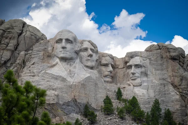
Mount Rushmore National Memorial
National Memorial
Majestic figures of George Washington, Thomas Jefferson, Theodore Roosevelt and Abraham Lincoln, surrounded by the beauty of the Black Hills of South Dakota, tell the story of the birth, growth, devel...
13 mi from route
~32 min detour
Free
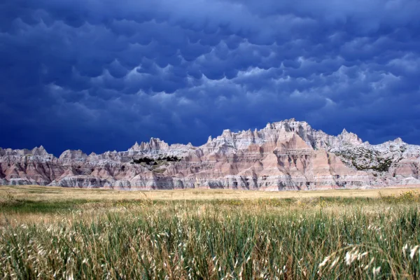
near mile 63.6
The rugged beauty of the Badlands draws visitors from around the world. These striking geologic deposits contain one of the world’s richest fossil beds. Ancient horses and rhinos once roamed here. The...
21 mi from route
~51 min detour
$30
near mile 37.6
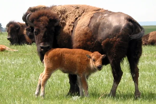
Wind Cave National Park protects two very different worlds - one deep within the earth, the other a sunlit world of many resources. Bison, elk, and other wildlife roam the rolling prairie grasslands a...
22 mi from route
~56 min detour
Free
near mile 60.7
Station data from NREL Alternative Fuel Stations database.
Driving Electric?
About $9 in charging
· 0 stops
· 66% less CO2
Vehicle Type
kWh
Stops
DC Fast
Home Charge
Average EV
25.1
0
$8.80
$4.02
Efficient EV
21
0
$7.33
$3.35
EV Truck/SUV
33.5
0
$11.73
$5.36
Gas CO2
29 kg
EV CO2
10 kg (66% less)
This trip is well within single-charge range for most EVs. No charging stops needed if you start fully charged.
DC fast charging avg $0.35/kWh. Home charging avg $0.16/kWh. US grid CO2: 0.39 kg/kWh.
Travel Intel
Current conditions at both ends of the drive.
Forecast as of Apr 15, 2026
Origin
Oglala, SD
Late night
in Oglala on Saturday
Local time
4:26 AM
MDT
Current temp
82°F
Unavailable
Live forecast
Destination
Box Elder, SD
Late night
in Box Elder on Saturday
Local time
4:26 AM
MDT
Current temp
46°F
Unavailable
Live forecast
Seasonal Notes
Summer travel usually means heavier construction, hotter rest stops, and busier weekend traffic around major cities.
Winter travel shortens daylight, so a route that looks manageable on paper can feel much longer after dark.
Holiday weekends tend to make both departure and arrival windows slower than the raw route time suggests.
Time zone
Same local time
Origin and destination are on the same clock, so arrival timing is easier to judge at a glance.
Temperature spread
36 degrees cooler at arrival
A meaningful temperature swing is a good cue to rethink layers, water, and how soon you want to arrive.
Road read
1h 54m on the road
Use the two city cards together: check the sky where you start, then compare it with the local time and temperature at arrival.
Weather data from the National Weather Service. Conditions may change; check closer to your travel date.
Frequently Asked Questions
The drive from Oglala, SD to Box Elder, SD covers 83.8 miles and takes about 1h 54m without stops. Add 15-30 minutes for a fuel or rest stop on longer drives.
The main roads are Bureau of Indian Affairs Highway 41, State Highway 40, South Highway 79. Most of the drive stays on highways, so watch for ramps and exits.
This is a comfortable same-day trip.
The midpoint is about 41.9 miles from Oglala, SD. Look for rest areas, gas stations, or food options near the halfway mark.
At current regular gas prices, expect to spend about $13.10 one way. This estimate uses 25.4 MPG — your actual cost will vary with your vehicle's fuel efficiency and current gas prices.
Leave by 9 AM and you'll arrive before lunch. Even a 4 PM departure gets you there before dark in summer.
This drive requires moderate attention. Across 83.8 miles you will encounter 11 spots where lane choice or exit timing matters. Not difficult for experienced highway drivers, but worth previewing the tricky sections before you go.
The main spots that need attention: at 0.1 miles (US 18): Navigation decision point; at 1.6 miles (BIA 41 / Lone Man Road): Navigation decision point; at 73.9 miles (SD 79): Highway fork - watch signs carefully.
The route from Oglala, SD to Box Elder, SD does not surface many named destination signs beyond the main corridor.
How this page is built
Compiled by the Trip.ovh planning team at COD Solutions Oy from open government datasets — OSRM over OpenStreetMap for geometry, EIA for fuel prices, NREL for EV charging, and NPS for national parks. See our methodology for refresh cadence and limitations.