
Trip from Phoenix, AZ to Rio Rico, AZ

Last recalculated Apr 17, 2026

Drive Time

3h 7m

Distance

169.7 mi

273 km

Drive Score

8/10

Great drive

Same Day?

Yes, doable

Fuel Cost

$34

one way

EV Charging

Unknown

Best Time to Leave

Save up to 35 min
4 AM
2h 56m ★
6 AM
3h 8m
8 AM
3h 31m
10 AM
3h 16m
12 PM
3h 14m
3 PM
3h 17m
5 PM
3h 30m
8 PM
3h 1m

Estimated drive times based on typical traffic patterns. Actual times may vary with weather, construction, and real-time conditions.

seat of Maricopa County, largest city in, and capital of, the State of Arizona, United States

Phoenix, AZ

Wikimedia Commons

Downtown Rio Rico, AZ, AZ

Rio Rico, AZ

Bruno Scramgnon

Trip Overview

The drive from Phoenix, AZ to Rio Rico, AZ covers 169.7 miles and takes about 3h 7m behind the wheel. This route is realistic as a one-day drive if you keep your stops efficient.

The route leans on Casa Grande-Tucson Highway, Nogales–Tucson Highway, Phoenix-Casa Grande Highway for much of the mileage, and the overall profile is turn-heavy local drive. The longest uninterrupted segment is about 54.6 miles on Casa Grande-Tucson Highway. At current regular gas prices, budget about $33.81 one way before food or hotel costs.

Trip Pace

Same-day drive is realistic

A same-day return is realistic if you keep stops short.

Break Rhythm

1 planned break

A short stop every 2 to 3 hours is enough for this drive.

Midpoint

84.9 miles from Phoenix, AZ

A natural place for your longest stop of the day , about 1h 31m into the drive .

Who Is This Route For?

Weekend Trip

Doable as a same-day drive at 3h 7m. Total distance: 169.7 miles.

Family Friendly

Moderate complexity with 1 natural rest stops along the way.

Solo Traveler

3h 7m drive, comfortable solo distance.

First-Time Driver

Mostly highway driving (12%). Some complex stretches to watch for.

Scenic Drive

Turn-heavy local drive route profile with national parks nearby.

Drive Character

Expect a 3h 7m drive with frequent turns across 169.7 miles of local and secondary roads.

This route has more turning and local-road decision points than a simple highway run.
There are about 23 navigation steps in the underlying route data, so the final approach matters more than the middle miles.
Casa Grande-Tucson Highway is the longest continuous segment at about 54.6 miles.

How Hard Is This Drive?

Expect a hands-on drive with frequent turns and local roads rather than long highway stretches. You will hit about 17 points where you need to pay attention to lane position or signs. The trickiest moment comes around 0.1 miles in near South 1st Avenue.

Driving Effort 5/10

Moderate - straightforward overall, but long enough or busy enough to require pacing

Balances navigation complexity with total wheel time.

This drive requires moderate attention. Across 169.7 miles you will encounter 17 spots where lane choice or exit timing matters. Not difficult for experienced highway drivers, but worth previewing the tricky sections before you go.

Where does it get tricky?

The main spots that need attention: at 0.1 miles (South 1st Avenue): Lane positioning matters here; at 0.1 miles (South 1st Avenue): Highway fork - watch signs carefully; at 2 miles (East Maricopa Freeway): Lane positioning matters here.

Critical Maneuvers

5 of 17 key points

These are the spots where you need to pay the most attention. Preview them before you drive.

7
0.1 mi into trip | ~0m in | South 1st Avenue

Turn left onto South 1st Avenue

Lane positioning matters here

Use the left lane.
5
0.1 mi into trip | ~0m in | South 1st Avenue

Keep slight left at fork onto South 1st Avenue

Highway fork - watch signs carefully

6
2 mi into trip | ~5m in | East Maricopa Freeway

Turn left onto East Maricopa Freeway

Lane positioning matters here

Use the left lane.
7
2 mi into trip | ~5m in

Take the ramp toward I 17 South, US 60 East

Lane positioning matters here. Multiple destination signs - pick the right one

Use the slight left lane. Toward I 17 South, US 60 East
7
114.1 mi into trip | ~2h 2m in

Take the exit toward I 19 South: Nogales

Exit ramp - move to the correct lane early. Lane positioning matters here

Use the straight / slight right lanes. Exit 260 Toward I 19 South: Nogales

Main Roads

Road Distance Duration
Casa Grande-Tucson Highway 54.6 mi 55m
Nogales–Tucson Highway 52.2 mi 56m
Phoenix-Casa Grande Highway 37.8 mi 38m
Maricopa Freeway 14 mi 16m
North Freeway 5.4 mi 6m
Rio Rico Drive 1.3 mi 3m
South 7th Street 0.9 mi 2m
Pendleton Drive 0.7 mi 1m
Longest stretch: Casa Grande-Tucson Highway — 54.6 mi, about 55m

Turn-by-Turn Driving Directions

Step-by-step road directions between Phoenix, AZ and Rio Rico, AZ.

1

Start on West Washington Street

322 ft · 18 sec · West Washington Street
2

Turn left onto South 1st Avenue

436 ft · 9 sec · South 1st Avenue
Use the left lane.
3

Keep slight left at fork onto South 1st Avenue

350 ft · 14 sec · South 1st Avenue
4

Turn left onto West Madison Street

0.1 mi · 31 sec · West Madison Street
5

At end of road, turn right onto South 1st Street

0.3 mi · 55 sec · South 1st Street
6

Turn left onto East Lincoln Street

0.4 mi · 1 min · East Lincoln Street
7

Turn right onto South 7th Street

0.9 mi · 2 min · South 7th Street
Use the right lane.
8

Turn left onto East Maricopa Freeway

290 ft · 8 sec · East Maricopa Freeway
Use the left lane.
9

Take the ramp

0.2 mi · 27 sec
Toward I 17 South, US 60 East Use the slight left lane.
10

Merge onto I 17; US 60

14 mi · 16 min · Maricopa Freeway
Use the straight / slight right lanes.
11

Continue on I 10

38 mi · 38 min · Phoenix-Casa Grande Highway
Use the straight / slight right lanes.
12

Continue on I 10

55 mi · 55 min · Casa Grande-Tucson Highway
Use the straight / slight right lanes.
13

Continue on I 10

5.4 mi · 6 min · North Freeway
Use the straight / slight right lanes.
14

Take the exit

0.5 mi · 37 sec
Exit 260 Toward I 19 South: Nogales Use the straight / slight right lanes.
15

Continue on I 19

52 mi · 56 min · Nogales–Tucson Highway
Use the straight / slight right lanes.
16

Take the exit

0.3 mi · 42 sec
Toward Rio Rico Drive, Yavapai Drive
17

Turn left onto Rio Rico Drive

1.3 mi · 3 min · Rio Rico Drive
18

Turn right onto Pendleton Drive

0.7 mi · 1 min · Pendleton Drive
19

Turn left onto Avenida Coatimundi

0.3 mi · 48 sec · Avenida Coatimundi
20

Turn left onto Avenida Leon

0.3 mi · 1 min · Avenida Leon
21

Turn left onto Yeso Court

290 ft · 19 sec · Yeso Court
22

Turn left

204 ft · 15 sec
23

Arrive at destination

Trip Plan

Morning Departure

An early start around 7-8 AM gets you there with plenty of daylight left.

Evening Departure

A late afternoon start means arriving after dark. Morning is better.

You can normally do this drive in one day.
Plan roughly 1 meaningful break for fuel, food, and rest.
The halfway point lands around 84.9 miles from Phoenix, AZ, or about 1h 31m into the drive.
The longest continuous stretch on this route runs about 54.6 miles.

This is a comfortable same-day trip.

Departure

Before you leave

Start with fuel, water, and navigation already sorted so the first hour feels easy.

First stop

Around 37 miles or 43m in

Use this first pause for coffee, a restroom break, and a quick traffic check ahead.

Halfway reset

Around 84.9 miles or 1h 31m in

This is the best place for your longest stop, a real meal, and a full fuel check.

Final approach

Final hour starts around 2h 29m

Traffic, exits, and arrival timing usually matter more near Rio Rico, AZ than in the middle of the route.

Before You Leave

+

Open the route before leaving Phoenix, AZ so your first major turns are already loaded.

+

Leave with enough water and a charging cable within reach, not packed away.

+

Check your fuel range against the first long segment, especially if you are starting outside city service areas.

Day 1

Settle into the route from Phoenix, AZ

This is one driving day of about 169.7 miles and 3h 7m.

Your first comfortable stop window is around 37 miles from Phoenix, AZ.
This route can stay practical as a one-day drive if traffic stays reasonable.
Plan about 1 real break rather than only quick fuel stops.
The longest stretch is on Casa Grande-Tucson Highway for about 54.6 miles.

Where to Stop

Rest stops, refuel points, and overnight suggestions along this route.

Halfway Point

Midpoint

About 84.9 mi from Phoenix, AZ · 1h 31m into the drive

census designated place in Pinal County, Arizona, United States

Mid-route town

Meal stop

Arizona City, AZ

85 mi into the route

Best for: Lunch, fuel, and a longer reset

This sits close to the middle of the route, so it works well for the longest stop of the day.

Pacing Suggestions

Casa Grande, AZ

Fuel and coffee

A short stop after about 37 miles helps settle the day before fatigue starts building.

Marana, AZ

Meal break

The midpoint is around 84.9 miles from Phoenix, AZ, which is a good place for a longer meal and fuel stop.

Arriving in Rio Rico, AZ

The final approach into Rio Rico, AZ usually feels slower than the middle of the drive, so avoid planning your tightest schedule at the very end.

Try to arrive with enough fuel left to skip an immediate station stop unless you already know the area around Rio Rico, AZ.

These stop ideas are pacing suggestions — the exact town or exit can change with traffic, hotel plans, and fuel range.

National Parks Near This Route

Worth a detour if your schedule allows.

Tumacácori National Historical Park

Tumacácori National Historical Park

National Historical Park

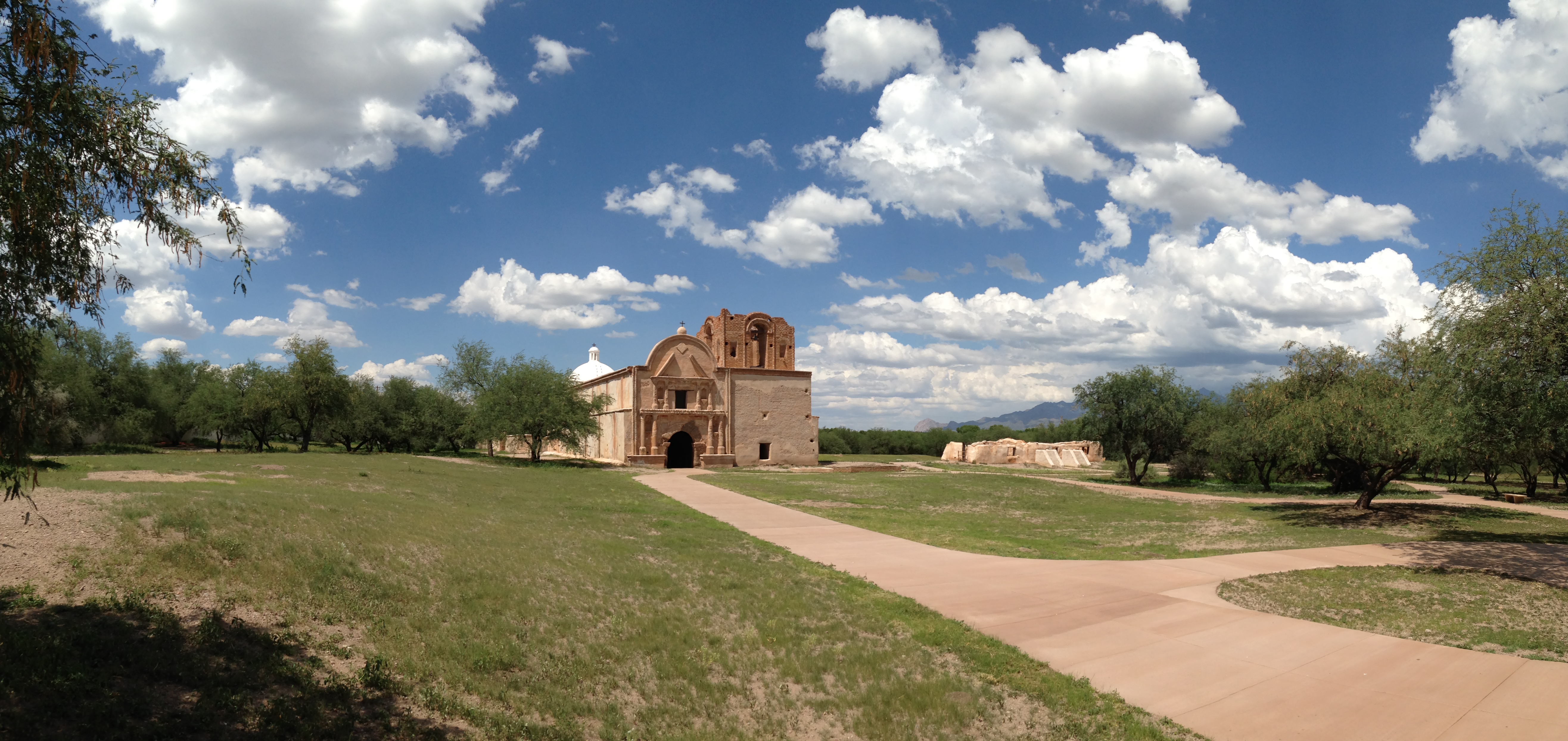
Tumacácori sits at a cultural crossroads in the Santa Cruz River valley. Here O’odham, Yaqui, and Apache people met and mingled with European Jesuit and Franciscan missionaries, settlers, and soldiers...

1 mi from route ~2 min detour $10 near mile 158
View on nps.gov
Casa Grande Ruins National Monument

Casa Grande Ruins National Monument

National Monument

An Ancestral Sonoran Desert People's farming community and "Great House" are preserved at Casa Grande Ruins. Whether a gathering place for people or simply a waypoint marker in an extensive system of...

11 mi from route ~27 min detour Free near mile 46.8
View on nps.gov
Saguaro National Park

Saguaro National Park

National Park

Tucson, Arizona is home to the nation's largest cacti. The giant saguaro is the universal symbol of the American west. These majestic plants, found only in a small portion of the United States, are pr...

14 mi from route ~34 min detour $25 near mile 111.2
View on nps.gov

Park data from the National Park Service API. Alerts update every 2 hours.

Fuel & Cost

Regular Gas

$33.81 one way

$67.61 round trip

$5.06/gal 25.4 MPG avg 59 kg CO2
Fuel Type $/gal One Way Round Trip
midgrade $5.36 $35.78 $71.55
premium $5.59 $37.35 $74.71
diesel $5.61 $37.47 $74.94

No toll roads detected on this route.

Estimated Trip Cost (one way, 1 person)

Fuel

$34

Meals

$25–$50

Total

$59–$84

Rough estimate based on US averages. Hotel $80–$140/night, meals $25–$50/day.

Estimated CO2 emission: 59.4 kg one way. Prices: EIA weekly data, 2026-04-13.

Driving Electric?

About $18 in charging · 0 stops · 66% less CO2

Vehicle Type kWh Stops DC Fast Home Charge
Average EV 50.9 0 $17.82 $8.15
Efficient EV 42.4 0 $14.85 $6.79
EV Truck/SUV 67.9 0 $23.76 $10.86

Gas CO2

59 kg

EV CO2

20 kg (66% less)

This trip is well within single-charge range for most EVs. No charging stops needed if you start fully charged.

DC fast charging avg $0.35/kWh. Home charging avg $0.16/kWh. US grid CO2: 0.39 kg/kWh.

Travel Intel

Current conditions at both ends of the drive.

Forecast as of Apr 15, 2026

Origin

Phoenix, AZ

Evening in Phoenix on Thursday

Local time

7:42 PM

MST

Current temp

93°F

Unavailable

Live forecast

Destination

Rio Rico, AZ

Evening in Rio Rico on Thursday

Local time

7:42 PM

MST

Current temp

86°F

Unavailable

Live forecast

Seasonal Notes

Summer travel usually means heavier construction, hotter rest stops, and busier weekend traffic around major cities.

Winter travel shortens daylight, so a route that looks manageable on paper can feel much longer after dark.

Holiday weekends tend to make both departure and arrival windows slower than the raw route time suggests.

Time zone

Same local time

Origin and destination are on the same clock, so arrival timing is easier to judge at a glance.

Temperature spread

7 degrees cooler at arrival

A meaningful temperature swing is a good cue to rethink layers, water, and how soon you want to arrive.

Road read

3h 7m on the road

Use the two city cards together: check the sky where you start, then compare it with the local time and temperature at arrival.

Weather data from the National Weather Service. Conditions may change; check closer to your travel date.

Frequently Asked Questions

The drive from Phoenix, AZ to Rio Rico, AZ covers 169.7 miles and takes about 3h 7m without stops. Add 15-30 minutes for a fuel or rest stop on longer drives.
The main roads are Casa Grande-Tucson Highway, Nogales–Tucson Highway, Phoenix-Casa Grande Highway. Expect a mix of highway and local road driving.
This is a comfortable same-day trip.
The midpoint is about 84.9 miles from Phoenix, AZ. Look for rest areas, gas stations, or food options near the halfway mark.
At current regular gas prices, expect to spend about $33.81 one way. This estimate uses 25.4 MPG — your actual cost will vary with your vehicle's fuel efficiency and current gas prices.
An early start around 7-8 AM gets you there with plenty of daylight left. A late afternoon start means arriving after dark. Morning is better.
Plan about 1 meaningful break for fuel, food, or rest. A short stop every 2 to 3 hours is enough for this drive.
This drive requires moderate attention. Across 169.7 miles you will encounter 17 spots where lane choice or exit timing matters. Not difficult for experienced highway drivers, but worth previewing the tricky sections before you go.
The main spots that need attention: at 0.1 miles (South 1st Avenue): Lane positioning matters here; at 0.1 miles (South 1st Avenue): Highway fork - watch signs carefully; at 2 miles (East Maricopa Freeway): Lane positioning matters here.
The route from Phoenix, AZ to Rio Rico, AZ does not surface many named destination signs beyond the main corridor.
Yes. Nearby national parks include Tumacácori National Historical Park, Casa Grande Ruins National Monument and Saguaro National Park.

Was this helpful?

Thanks for your feedback!

Your tip has been submitted. Thanks!

/500

Explore More

Explore more options from Phoenix, AZ or browse trips ending in Rio Rico, AZ.

Looking for more statewide routes? Browse AZ road trips.

Explore maps for Phoenix, AZ or Rio Rico, AZ on MapSof.net.