Trip from Portageville, MO to Independence, MO

Drive Time

7h 35m

Distance

403.9 mi

650 km

Drive Score

9/10

Great drive

Same Day?

Yes, doable

Fuel Cost

$61

one way

EV Charging

None

0 DC fast

Best Time to Leave

Save up to 30 min
4 AM
7h 25m ★
6 AM
7h 35m
8 AM
7h 55m
10 AM
7h 42m
12 PM
7h 40m
3 PM
7h 43m
5 PM
7h 54m
8 PM
7h 29m

Estimated drive times based on typical traffic patterns. Actual times may vary with weather, construction, and real-time conditions.

Downtown Independence, MO, MO

Independence, MO

Ever Rayan

Trip Overview

The drive from Portageville, MO to Independence, MO covers 403.9 miles and takes about 7h 35m behind the wheel. This route is realistic as a one-day drive if you keep your stops efficient.

The route leans on I 55, Dwight D Eisenhower Highway, U.S. Submarine Veterans' Memorial Highway for much of the mileage, and the overall profile is mixed drive. The longest uninterrupted segment is about 162 miles on I 55. At current regular gas prices, budget about $61.35 one way before food or hotel costs.

Trip Pace

Same-day drive is realistic

A same-day return is possible, but it will make for a full day on the road.

Break Rhythm

2 planned breaks

Plan on a short reset every 3 to 4 hours to stay fresh behind the wheel.

Midpoint

202 miles from Portageville, MO

A natural place for your longest stop of the day , about 3h 44m into the drive .

Drive Character

The drive from Portageville, MO to Independence, MO covers 403.9 miles and takes about 7h 35m, using a mix of highways and local roads.

Expect a mix of faster highway mileage and slower local approaches near the beginning or end.
There are about 29 navigation steps in the underlying route data, so the final approach matters more than the middle miles.
I 55 is the longest continuous segment at about 162 miles.

How Hard Is This Drive?

This route mixes highway mileage with some local-road sections near the start or finish. This route has several spots where lane changes, forks, or exits need your full attention. The trickiest moment comes around 164.3 miles in.

Route Complexity 10/10

High effort - long or complex enough to need steady focus all day

This is a demanding drive. With 16 significant decision points across 403.9 miles, you will need to stay alert — especially through interchange areas and urban stretches. Consider splitting it into segments if you are not comfortable with fast highway navigation.

Where does it get tricky?

The main spots that need attention: at 164.3 miles: Exit ramp - move to the correct lane early. Lane positioning matters here. Multiple destination signs - pick the right one; at 164.6 miles: Highway fork - watch signs carefully. Lane positioning matters here; at 176.9 miles: Exit ramp - move to the correct lane early. Lane positioning matters here. Multiple destination signs - pick the right one.

Critical Maneuvers

5 of 16 key points

These are the spots where you need to pay the most attention. Preview them before you drive.

8
164.3 mi into trip | ~2h 57m in

Take the exit toward I 270 West, I 255 East: Kansas City, Chicago

Exit ramp - move to the correct lane early. Lane positioning matters here. Multiple destination signs - pick the right one

Use the slight right lane. Exit 196 Toward I 270 West, I 255 East: Kansas City, Chi...
8
164.6 mi into trip | ~2h 58m in

Keep slight left at fork toward I 270 West: Kansas City

Highway fork - watch signs carefully. Lane positioning matters here

Use the slight left lane. Toward I 270 West: Kansas City
8
176.9 mi into trip | ~3h 13m in

Take the exit toward I 64, US 40, US 61: Wentzville, Saint Louis

Exit ramp - move to the correct lane early. Lane positioning matters here. Multiple destination signs - pick the right one

Use the slight right lane. Exit 12 Toward I 64, US 40, US 61: Wentzville, Saint Lo...
8
177 mi into trip | ~3h 14m in

Keep slight left at fork toward I 64 West, US 40 West, US 61 North: Wentzville

Highway fork - watch signs carefully. Lane positioning matters here. Multiple destination signs - pick the right one

Use the slight left lane. Toward I 64 West, US 40 West, US 61 North: Went...
8
202.9 mi into trip | ~3h 45m in | US 40

Take the exit onto US 40 toward I 70 West, US 40 West: Kansas City

Exit ramp - move to the correct lane early. Lane positioning matters here. Multiple destination signs - pick the right one

Use the straight / slight left lanes. Exit 1A Toward I 70 West, US 40 West: Kansas City

Towns Along This Route

Between Portageville, MO and Independence, MO, road signs point toward Chicago and Saint Louis.

Chicago

164.3 mi in | ~2h 57m

Saint Louis

176.9 mi in | ~3h 13m

Main Roads

Road Distance Duration
I 55 162 mi 2h 54m
Dwight D Eisenhower Highway 80.7 mi 1h 35m
U.S. Submarine Veterans' Memorial Highway 54.4 mi 58m
Dwight D. Eisenhower Highway 54.3 mi 58m
Avenue of the Saints 25.4 mi 30m
I 270 11.5 mi 14m
South Noland Road 3 mi 5m
Truman/Eisenhower Presidential Highway 2.7 mi 3m
Longest stretch: I 55 — 162 mi, about 2h 54m

Turn-by-Turn Driving Directions

Step-by-step road directions between Portageville, MO and Independence, MO.

1

Start on Main Street

0.2 mi · 23 sec · Main Street
2

Continue on US 61; MO 162

0.7 mi · 1 min · US 61; MO 162
3

Take the ramp

0.2 mi · 24 sec
Toward I 55 North: Sikeston
4

Merge onto I 55

60 mi · 1 hr 4 min · I 55
5

Keep slight left at fork onto I 55

102 mi · 1 hr 49 min · I 55
6

Continue on I 55

1.3 mi · 1 min · Rosa Parks Highway
7

Take the exit

0.2 mi · 27 sec
Exit 196 Toward I 270 West, I 255 East: Kansas City, Chicago Use the slight right lane.
8

Keep slight left at fork

388 ft · 8 sec
Toward I 270 West: Kansas City Use the slight left lane.
9

Continue on this road

0.7 mi · 1 min · this road
Exit 196 Toward I 270 West
10

Merge onto I 270

11 mi · 14 min · I 270
Use the straight lane.
11

Take the exit

0.1 mi · 17 sec
Exit 12 Toward I 64, US 40, US 61: Wentzville, Saint Louis Use the slight right lane.
12

Keep slight left at fork

0.4 mi · 48 sec
Toward I 64 West, US 40 West, US 61 North: Wentzville Use the slight left lane.
13

Continue on this road

0.1 mi · 9 sec · this road
Exit 12 Toward I 64 West, US 40 West, US 61 North: Wentzville
14

Merge onto I 64; US 40; US 61

25 mi · 30 min · Avenue of the Saints
Use the straight lane.
15

Take the exit onto US 40

0.6 mi · 1 min · US 40
Exit 1A Toward I 70 West, US 40 West: Kansas City Use the straight / slight left lanes.
16

Merge onto I 70; US 40

81 mi · 1 hr 35 min · Dwight D Eisenhower Highway
17

Continue on I 70; US 40

2.0 mi · 2 min · Sheriff Roger I. Wilson Memorial Highway
18

Continue on I 70; US 40

1.6 mi · 1 min · Highway Patrol Sgt. Benjamin Booth Memorial Highway
19

Continue on I 70; US 40

1.8 mi · 2 min · Dwight D. Eisenhower Highway
20

Continue on I 70; US 40

54 mi · 58 min · U.S. Submarine Veterans' Memorial Highway
21

Continue on I 70; US 40

52 mi · 56 min · Dwight D. Eisenhower Highway
22

Continue on I 70

2.7 mi · 3 min · Truman/Eisenhower Presidential Highway
23

Continue on I 70

1.4 mi · 1 min · Clifton J. Scott Memorial Highway
Use the straight / slight right lanes.
24

Take the exit

0.2 mi · 23 sec
Exit 12 Toward Noland Road Use the straight / slight right lanes.
25

Turn right onto South Noland Road

3.0 mi · 5 min · South Noland Road
26

Turn left onto East Walnut Street

466 ft · 22 sec · East Walnut Street
27

Turn right onto South Lynn Street

394 ft · 22 sec · South Lynn Street
28

Turn left onto East Kansas Avenue

145 ft · 6 sec · East Kansas Avenue
29

Arrive at destination

East Kansas Avenue

Trip Plan

Morning Departure

Start early — leave by 6-7 AM to arrive at a reasonable hour.

Evening Departure

This is a long drive — plan for a morning departure or consider splitting it into two days.

You can normally do this drive in one day.
Plan roughly 2 meaningful breaks for fuel, food, and rest.
The halfway point lands around 202 miles from Portageville, MO, or about 3h 44m into the drive.
The longest continuous stretch on this route runs about 162 miles.

This is a comfortable same-day trip.

Departure

Before you leave

Start with fuel, water, and navigation already sorted so the first hour feels easy.

First stop

Around 89 miles or 1h 36m in

Use this first pause for coffee, a restroom break, and a quick traffic check ahead.

Halfway reset

Around 202 miles or 3h 44m in

This is the best place for your longest stop, a real meal, and a full fuel check.

Final approach

Final hour starts around 6h 27m

Traffic, exits, and arrival timing usually matter more near Independence, MO than in the middle of the route.

Before You Leave

+

Open the route before leaving Portageville, MO so your first major turns are already loaded.

+

Leave with enough water and a charging cable within reach, not packed away.

+

Check your fuel range against the first long segment, especially if you are starting outside city service areas.

+

Pick one backup stop option before the midpoint in case traffic changes your pacing.

Day 1

Settle into the route from Portageville, MO

This is one driving day of about 403.9 miles and 7h 35m.

Your first comfortable stop window is around 89 miles from Portageville, MO.
This route can stay practical as a one-day drive if traffic stays reasonable.
Plan about 2 real breaks rather than only quick fuel stops.
The longest stretch is on I 55 for about 162 miles.

Where to Stop

Rest stops, refuel points, and overnight suggestions along this route.

Halfway Point

Midpoint

About 202 mi from Portageville, MO · 3h 44m into the drive

Downtown Alton, IL, IL

Mid-route town

Meal stop

Alton, IL

202 mi into the route

Best for: Lunch, fuel, and a longer reset

This sits close to the middle of the route, so it works well for the longest stop of the day.

Pacing Suggestions

Campton, IL

Fuel and coffee

A short stop after about 89 miles helps settle the day before fatigue starts building.

Alton, IL

Meal break

The midpoint is around 202 miles from Portageville, MO, which is a good place for a longer meal and fuel stop.

Before the longest stretch

Fuel check

Top up before I 55 if your tank is already low. That segment runs about 162 miles.

Arriving in Independence, MO

The final approach into Independence, MO usually feels slower than the middle of the drive, so avoid planning your tightest schedule at the very end.

Try to arrive with enough fuel left to skip an immediate station stop unless you already know the area around Independence, MO.

After long uninterrupted mileage, take five minutes before the last urban segment to reset and refocus on exits, merges, and city traffic.

These stop ideas are pacing suggestions — the exact town or exit can change with traffic, hotel plans, and fuel range.

National Parks Near This Route

Worth a detour if your schedule allows.

Ste. Geneviève National Historical Park

Ste. Geneviève National Historical Park

National Historical Park

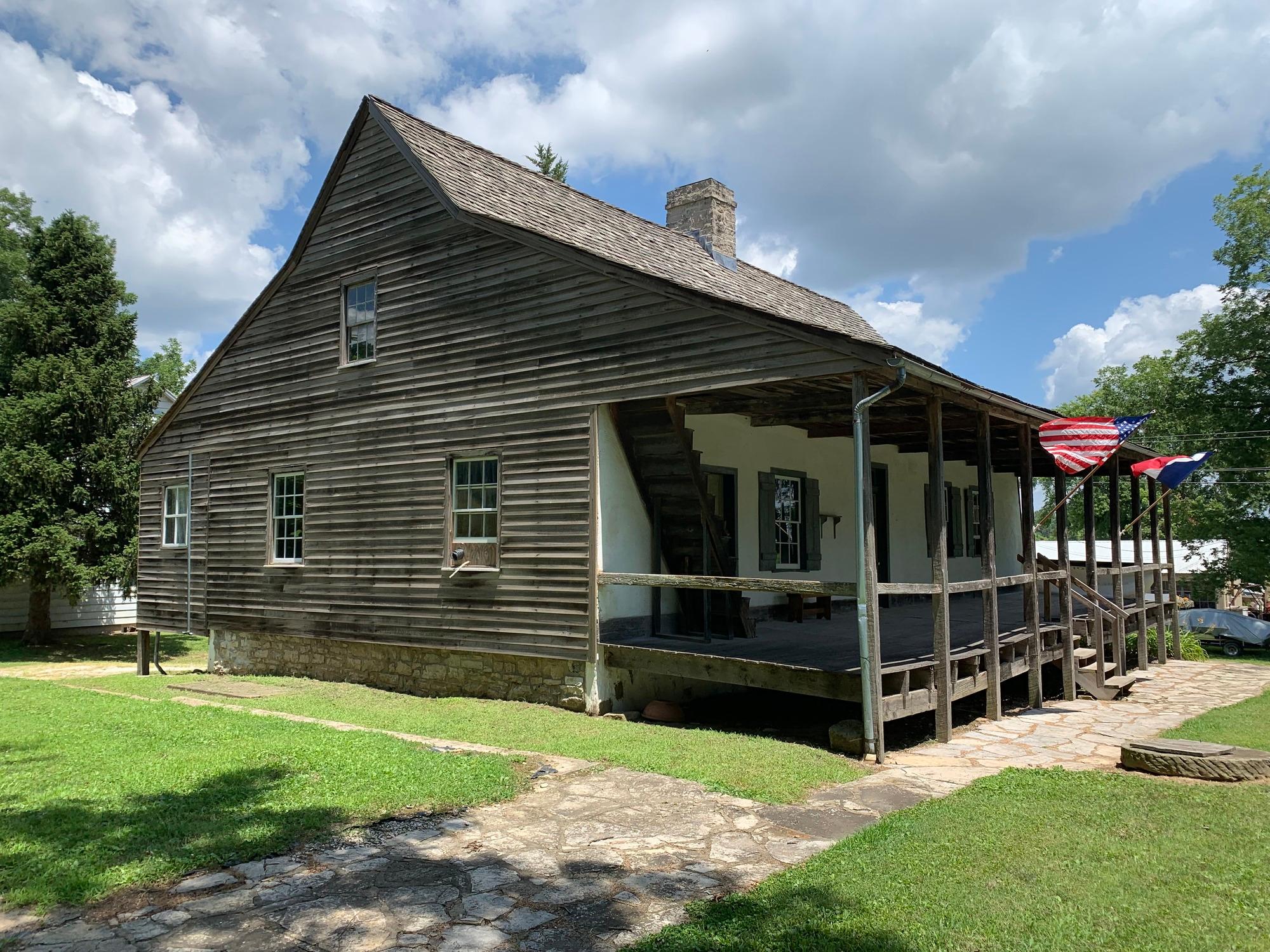
Established by 1750, Ste. Geneviève was the first permanent European settlement in Missouri. Early French Canadian settlers were drawn here by the rich agricultural land known as Le Grand Champ (the B...

8 mi from route ~19 min detour Free near mile 111.4
Park Closure: Delassus-Kern House and Grounds Closed
View on nps.gov
Gateway Arch National Park

Gateway Arch National Park

National Park

Gateway Arch National Park commemorates President Jefferson’s vision of a continental nation, the individuals and cultural groups who helped shape its history, St. Louis’ role in westward expansion, a...

13 mi from route ~32 min detour $19 near mile 167.1
View on nps.gov

Park data from the National Park Service API. Alerts update every 2 hours.

Fuel & Cost

Regular Gas

$61.35 one way

$122.70 round trip

$3.86/gal 25.4 MPG avg 141 kg CO2
Fuel Type $/gal One Way Round Trip
midgrade $4.25 $67.63 $135.26
premium $4.80 $76.25 $152.50
diesel $5.64 $89.73 $179.47

No toll roads detected on this route.

Estimated Trip Cost (one way, 1 person)

Fuel

$61

Meals

$25–$50

Total

$86–$111

Rough estimate based on US averages. Hotel $80–$140/night, meals $25–$50/day.

Estimated CO2 emission: 141.3 kg one way. Prices: EIA weekly data, 2026-04-06.

Driving Electric?

About $42 in charging · 1 stop · 67% less CO2

Vehicle Type kWh Stops DC Fast Home Charge
Average EV 121.2 1 $42.41 $19.39
Efficient EV 101 1 $35.34 $16.16
EV Truck/SUV 161.6 2 $56.55 $25.85

Gas CO2

141 kg

EV CO2

47 kg (67% less)

Plan for 1 charging stop. A 30-minute DC fast charge mid-route should be enough to complete the trip comfortably.

DC fast charging avg $0.35/kWh. Home charging avg $0.16/kWh. US grid CO2: 0.39 kg/kWh.

Travel Intel

Current conditions at both ends of the drive.

Forecast data refreshed 3 days ago

Origin

Portageville, MO

Afternoon in Portageville on Monday

Local time

12:29 PM

CDT

Current temp

64°F

Unavailable

Live forecast

Destination

Independence, MO

Afternoon in Independence on Monday

Local time

12:29 PM

CDT

Current temp

49°F

Unavailable

Live forecast

Seasonal Notes

Summer travel usually means heavier construction, hotter rest stops, and busier weekend traffic around major cities.

Winter travel shortens daylight, so a route that looks manageable on paper can feel much longer after dark.

Holiday weekends tend to make both departure and arrival windows slower than the raw route time suggests.

Time zone

Same local time

Origin and destination are on the same clock, so arrival timing is easier to judge at a glance.

Temperature spread

15 degrees cooler at arrival

A meaningful temperature swing is a good cue to rethink layers, water, and how soon you want to arrive.

Road read

7h 35m on the road

Start early — leave by 6-7 AM to arrive at a reasonable hour.

Weather data from the National Weather Service. Conditions may change; check closer to your travel date.

Frequently Asked Questions

The drive from Portageville, MO to Independence, MO covers 403.9 miles and takes about 7h 35m without stops. Add 15-30 minutes for a fuel or rest stop on longer drives.
The main roads are I 55, Dwight D Eisenhower Highway, U.S. Submarine Veterans' Memorial Highway. Expect a mix of highway and local road driving.
This is a comfortable same-day trip.
The midpoint is about 202 miles from Portageville, MO. Look for rest areas, gas stations, or food options near the halfway mark.
At current regular gas prices, expect to spend about $61.35 one way. This estimate uses 25.4 MPG — your actual cost will vary with your vehicle's fuel efficiency and current gas prices.
Start early — leave by 6-7 AM to arrive at a reasonable hour. This is a long drive — plan for a morning departure or consider splitting it into two days.
Plan about 2 meaningful breaks for fuel, food, or rest. Plan on a short reset every 3 to 4 hours to stay fresh behind the wheel.
This is a demanding drive. With 16 significant decision points across 403.9 miles, you will need to stay alert — especially through interchange areas and urban stretches. Consider splitting it into segments if you are not comfortable with fast highway navigation.
The main spots that need attention: at 164.3 miles: Exit ramp - move to the correct lane early. Lane positioning matters here. Multiple destination signs - pick the right one; at 164.6 miles: Highway fork - watch signs carefully. Lane positioning matters here; at 176.9 miles: Exit ramp - move to the correct lane early. Lane positioning matters here. Multiple destination signs - pick the right one.
Between Portageville, MO and Independence, MO, road signs point toward Chicago and Saint Louis.

Was this route helpful?

Thanks for your feedback!

Your tip has been submitted. Thanks!

/500

Explore More

Explore more options from Portageville, MO or browse trips ending in Independence, MO.

Looking for more statewide routes? Browse MO road trips.

Explore maps for Portageville, MO or Independence, MO on MapSof.net.