The drive from Reno, NV to Caliente, NV covers 453.2 miles and takes about 8h 53m behind the wheel.
It usually feels better as a 2-day road trip than as one long push.
The route leans on Lincoln Highway, Great Basin Highway, Austin Highway for much of the mileage,
and the overall profile is turn-heavy local drive.
The longest uninterrupted segment is about 167.9 miles on Lincoln Highway.
At current regular gas prices, budget about $90.28 one way before food or hotel costs.
Trip Pace
Best split across 2 days
Treat the return leg as its own travel day rather than an afterthought.
Break Rhythm
2 planned breaks
Plan on a short reset every 3 to 4 hours to stay fresh behind the wheel.
Midpoint
226.6 miles from Reno, NV
A natural place for your longest stop of the day
, about 4h 23m into the drive
.
Who Is This Route For?
Family Friendly
Moderate complexity with 2 natural rest stops along the way.
Solo Traveler
8h 53m drive, plan rest stops for pacing.
Scenic Drive
Turn-heavy local drive route profile with national parks nearby.
Drive Character
Expect a 8h 53m drive with frequent turns across 453.2 miles of local and secondary roads.
This route has more turning and local-road decision points than a simple highway run.
There are about 27 navigation steps in the underlying route data, so the final approach matters more than the middle miles.
Lincoln Highway is the longest continuous segment at about 167.9 miles.
How Hard Is This Drive?
Expect a hands-on drive with frequent turns and local roads rather than long highway stretches. There are only a few real navigation decisions along the way. The trickiest moment comes around 0.1 miles in near East 4th Street.
Driving Effort4/10
Easy - simple navigation with a manageable amount of wheel time
Balances navigation complexity with total wheel time.
The route itself is not hard, but at 8h 53m, endurance matters. Plan breaks every 2-3 hours. The 10 decision points are all manageable with basic attention.
Where does it get tricky?
The main spots that need attention: at 0.1 miles (East 4th Street): Navigation decision point; at 0.1 miles (University Way): Navigation decision point; at 0.4 miles (East Maple Street): Multiple destination signs - pick the right one.
Critical Maneuvers
5 of 10 key points
These are the spots where you need to pay the most attention. Preview them before you drive.
5
0.1 mi into trip|~0m in|East 4th Street
Turn right onto East 4th Street
Navigation decision point
5
0.1 mi into trip|~0m in|University Way
Turn left onto University Way
Navigation decision point
6
0.4 mi into trip|~1m in|East Maple Street
Take the ramp onto East Maple Street toward I 80 East: Elko, Salt Lake City, Winnemucca
Multiple destination signs - pick the right one
Toward I 80 East: Elko, Salt Lake City, Winnemu...
6
35.2 mi into trip|~41m in
Take the exit toward I 80 BUS West, US 95 ALT South: East Fernley, Yerington
Exit ramp - move to the correct lane early. Multiple destination signs - pick the right one
Exit 48
Toward I 80 BUS West, US 95 ALT South: East Fer...
5
36.4 mi into trip|~43m in|US 50 ALT
Enter roundabout onto US 50 ALT
Roundabout - know your exit number before entering
Towns Mentioned on Route Signs
Based on OSRM destination-sign hints, not a full list of every settlement the road passes.
On the drive from Reno, NV to Caliente, NV, road signs begin pointing toward Yerington along the way.
Yerington
35.2 mi in|~41m
Main Roads
Road
Distance
Duration
Lincoln Highway
167.9 mi
3h 12m
Great Basin Highway
130.4 mi
2h 32m
Austin Highway
85.4 mi
1h 33m
Dwight D. Eisenhower Highway
34.6 mi
39m
US 50 ALT
24.6 mi
30m
West Williams Avenue
2.5 mi
5m
North Main Street
2 mi
4m
Aultman Street
1.4 mi
3m
Longest stretch:
Lincoln Highway
— 167.9 mi, about 3h 12m
Turn-by-Turn Driving Directions
Step-by-step road directions between Reno, NV and Caliente, NV.
1
Start on this road
105 ft·12 sec·this road
2
Turn left
171 ft·14 sec
3
Turn right onto East 4th Street
186 ft·13 sec·East 4th Street
4
Turn left onto University Way
0.3 mi·53 sec·University Way
5
Take the ramp onto East Maple Street
0.2 mi·16 sec·East Maple Street
Toward I 80 East: Elko, Salt Lake City, Winnemucca
6
Merge onto I 80
35 mi·39 min·Dwight D. Eisenhower Highway
7
Take the exit
0.5 mi·52 sec
Exit 48Toward I 80 BUS West, US 95 ALT South: East Fernley, Yerington
8
Turn right onto I 80 BUS; US 95 ALT
0.7 mi·1 min·I 80 BUS; US 95 ALT
Use the left lane.
9
Continue on NV 828
341 ft·9 sec·Farm District Road
10
Enter roundabout onto US 50 ALT
298 ft·7 sec·US 50 ALT
11
Continue on US 50 ALT
1.7 mi·2 min·US 50 ALT
12
Continue on US 50 ALT
5.8 mi·6 min·US 50 ALT
13
Continue on US 50 ALT
17 mi·21 min·US 50 ALT
Use the left lane.
14
Continue on US 50
2.5 mi·5 min·West Williams Avenue
15
Continue on US 50
85 mi·1 hr 33 min·Austin Highway
16
Continue on US 50
24 mi·26 min·Lincoln Highway
17
Continue on US 50
0.6 mi·1 min·Main Street
18
Continue on US 50
68 mi·1 hr 18 min·Lincoln Highway
19
Continue on US 50
2.0 mi·4 min·North Main Street
20
Continue on US 50
76 mi·1 hr 27 min·Lincoln Highway
21
Continue on US 50
1.4 mi·3 min·Aultman Street
22
Turn right onto US 50; US 93
1.1 mi·2 min·Great Basin Boulevard
23
Continue on US 6; US 50; US 93
26 mi·33 min·Great Basin Highway
24
Continue on US 93
105 mi·1 hr 58 min·Great Basin Highway
25
Continue on US 93
0.8 mi·1 min·North Spring Street
26
Turn right onto Market Street
119 ft·5 sec·Market Street
27
Arrive at destination
Market Street
Trip Plan
Morning Departure
Start early — leave by 6-7 AM to arrive at a reasonable hour.
Evening Departure
This is a long drive — plan for a morning departure or consider splitting it into two days.
This drive is better paced as a 2-day trip.
Plan roughly 2 meaningful breaks for fuel, food, and rest.
The halfway point lands around 226.6 miles from Reno, NV, or about 4h 23m into the drive.
The longest continuous stretch on this route runs about 167.9 miles.
Consider an overnight stop or starting very early.
Departure
Before you leave
Start with fuel, water, and navigation already sorted so the first hour feels easy.
First stop
Around 100 miles or 2h in
Use this first pause for coffee, a restroom break, and a quick traffic check ahead.
Halfway reset
Around 226.6 miles or 4h 23m in
This is the best place for your longest stop, a real meal, and a full fuel check.
Overnight split
Day 1 wrap after about 226.6 miles or 4h 23m
Stop before fatigue turns the last few hours into a grind. You want day two to start fresh, not just resumed.
Final approach
Final hour starts around 7h 44m
Traffic, exits, and arrival timing usually matter more near Caliente, NV than in the middle of the route.
Before You Leave
+
Open the route before leaving Reno, NV so your first major turns are already loaded.
+
Leave with enough water and a charging cable within reach, not packed away.
+
Check your fuel range against the first long segment, especially if you are starting outside city service areas.
+
Pick one backup stop option before the midpoint in case traffic changes your pacing.
+
Treat this as a 2-day road trip and book the overnight stop before the busiest arrival window.
Day 1
Settle into the route from Reno, NV
Aim for roughly 227 miles and 4.4 hours of wheel time on this day.
Day 2
Finish the approach into Caliente, NV
Aim for roughly 227 miles and 4.4 hours of wheel time on this day.
Your first comfortable stop window is around 100 miles from Reno, NV.
This route usually feels better as a 2-day drive than as one long push.
Plan about 2 real breaks rather than only quick fuel stops.
The longest stretch is on Lincoln Highway for about 167.9 miles.
Where to Stop
Rest stops, refuel points, and overnight suggestions along this route.
Halfway Point
Midpoint
About 226.6 mi from Reno, NV
· 4h 23m into the drive
The midpoint is around 226.6 miles from Reno, NV, which is a good place for a longer meal and fuel stop.
Before the longest stretch
Fuel check
Top up before Lincoln Highway if your tank is already low. That segment runs about 167.9 miles.
Overnight split
Hotel stop
For a steadier pace, wrap day one after about 227 miles or 4.4 hours on the road.
Arriving in Caliente, NV
The final approach into Caliente, NV usually feels slower than the middle of the drive, so avoid planning your tightest schedule at the very end.
Try to arrive with enough fuel left to skip an immediate station stop unless you already know the area around Caliente, NV.
On a multi-day trip, keep the last day a little lighter so you reach Caliente, NV with some flexibility left in the schedule.
After long uninterrupted mileage, take five minutes before the last urban segment to reset and refocus on exits, merges, and city traffic.
These stop ideas are pacing suggestions — the exact town or exit can change with traffic, hotel plans, and fuel range.
National Parks Near This Route
Worth a detour if your schedule allows.
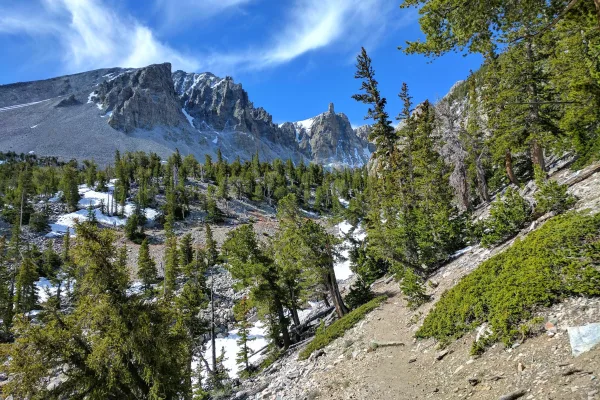
Great Basin National Park
National Park
From the 13,063-foot summit of Wheeler Peak to the sagebrush-covered foothills, Great Basin National Park hosts a sample of the incredible diversity of the larger Great Basin region. Come and partake...
15 mi from route
~38 min detour
Free
near mile 359.4
Park data from the National Park Service API. Alerts update every 2 hours.
Fuel & Cost
Regular Gas
$90.28 one way
$180.57 round trip
$5.06/gal25.4 MPG avg159 kg CO2
Fuel Type
$/gal
One Way
Round Trip
midgrade
$5.36
$95.55
$191.09
premium
$5.59
$99.76
$199.52
diesel
$5.61
$100.06
$200.12
No toll roads detected on this route.
Estimated Trip Cost (one way, 1 person)
Fuel
$90
Hotel (1n)
$80–$140
Meals
$50–$100
Total
$220–$330
Rough estimate based on US averages. Hotel $80–$140/night, meals $25–$50/day.
Estimated CO2 emission: 158.6 kg one way.
Prices: EIA weekly data, 2026-04-13.
Driving Electric?
About $48 in charging
· 1 stop
· 67% less CO2
Vehicle Type
kWh
Stops
DC Fast
Home Charge
Average EV
136
1
$47.59
$21.75
Efficient EV
113.3
1
$39.65
$18.13
EV Truck/SUV
181.3
2
$63.45
$29.00
Gas CO2
159 kg
EV CO2
53 kg (67% less)
Plan for 1 charging stop. A 30-minute DC fast charge mid-route should be enough to complete the trip comfortably.
DC fast charging avg $0.35/kWh. Home charging avg $0.16/kWh. US grid CO2: 0.39 kg/kWh.
Travel Intel
Current conditions at both ends of the drive.
Forecast as of Apr 14, 2026
Origin
Reno, NV
Late night
in Reno on Saturday
Local time
1:57 AM
PDT
Current temp
31°F
Mostly Clear
0 mph0% chanceLive forecast
Lake Wind Advisory
Lake Wind Advisory issued April 14 at 12:37AM PDT until April 15 at 11:00PM PDT by NWS Reno NV
Wind Advisory
Wind Advisory issued April 14 at 12:37AM PDT until April 15 at 11:00PM PDT by NWS Reno NV
Destination
Caliente, NV
Late night
in Caliente on Saturday
Local time
1:57 AM
PDT
Current temp
32°F
Partly Cloudy
W 2 mph9% chanceLive forecast
Lake Wind Advisory
Lake Wind Advisory issued April 14 at 12:37AM PDT until April 15 at 11:00PM PDT by NWS Reno NV
Wind Advisory
Wind Advisory issued April 14 at 12:37AM PDT until April 15 at 11:00PM PDT by NWS Reno NV
Seasonal Notes
Summer travel usually means heavier construction, hotter rest stops, and busier weekend traffic around major cities.
Winter travel shortens daylight, so a route that looks manageable on paper can feel much longer after dark.
Holiday weekends tend to make both departure and arrival windows slower than the raw route time suggests.
For long drives, weather on day two can matter just as much as conditions at departure, so check the whole travel window rather than only the first day.
Time zone
Same local time
Origin and destination are on the same clock, so arrival timing is easier to judge at a glance.
Temperature spread
1 degrees warmer at arrival
A meaningful temperature swing is a good cue to rethink layers, water, and how soon you want to arrive.
Road read
8h 53m on the road
This is long enough that the arrival forecast matters almost as much as departure conditions. Recheck both ends before you roll.
Weather data from the National Weather Service. Conditions may change; check closer to your travel date.
Frequently Asked Questions
The drive from Reno, NV to Caliente, NV covers 453.2 miles and takes about 8h 53m without stops. Add 15-30 minutes for a fuel or rest stop on longer drives.
The main roads are Lincoln Highway, Great Basin Highway, Austin Highway. Expect a mix of highway and local road driving.
Consider an overnight stop or starting very early.
Yes. This route is usually more comfortable as a 2-day drive. A sensible stopping point is after roughly 227 miles on day one.
The midpoint is about 226.6 miles from Reno, NV. Look for rest areas, gas stations, or food options near the halfway mark.
At current regular gas prices, expect to spend about $90.28 one way. This estimate uses 25.4 MPG — your actual cost will vary with your vehicle's fuel efficiency and current gas prices.
Start early — leave by 6-7 AM to arrive at a reasonable hour. This is a long drive — plan for a morning departure or consider splitting it into two days.
Plan about 2 meaningful breaks for fuel, food, or rest. Plan on a short reset every 3 to 4 hours to stay fresh behind the wheel.
The route itself is not hard, but at 8h 53m, endurance matters. Plan breaks every 2-3 hours. The 10 decision points are all manageable with basic attention.
The main spots that need attention: at 0.1 miles (East 4th Street): Navigation decision point; at 0.1 miles (University Way): Navigation decision point; at 0.4 miles (East Maple Street): Multiple destination signs - pick the right one.
On the drive from Reno, NV to Caliente, NV, road signs begin pointing toward Yerington along the way.
Yes. Nearby national parks include Great Basin National Park.
How this page is built
Compiled by the Trip.ovh planning team at COD Solutions Oy from open government datasets — OSRM over OpenStreetMap for geometry, EIA for fuel prices, and NPS for national parks. See our methodology for refresh cadence and limitations.