Trip from Ridgeland, MS to Corinth, MS

Drive Time

4h 42m

Distance

247.4 mi

398 km

Drive Score

8/10

Great drive

Same Day?

Yes, doable

Fuel Cost

$38

one way

EV Charging

Excellent

29 DC fast

Best Time to Leave

Save up to 40 min
4 AM
4h 29m ★
6 AM
4h 42m
8 AM
5h 9m
10 AM
4h 52m
12 PM
4h 49m
3 PM
4h 53m
5 PM
5h 8m
8 PM
4h 34m

Estimated drive times based on typical traffic patterns. Actual times may vary with weather, construction, and real-time conditions.

Downtown Ridgeland, MS, MS

Ridgeland, MS

大 董

Downtown Corinth, MS, MS

Corinth, MS

ROMAN ODINTSOV

Trip Overview

The drive from Ridgeland, MS to Corinth, MS covers 247.4 miles and takes about 4h 42m behind the wheel. This route is realistic as a one-day drive if you keep your stops efficient.

The route leans on I 55, US 45, MS 7 for much of the mileage, and the overall profile is highway-focused drive. The longest uninterrupted segment is about 105.2 miles on I 55. At current regular gas prices, budget about $37.82 one way before food or hotel costs.

Trip Pace

Same-day drive is realistic

A same-day return is possible, but it will make for a full day on the road.

Break Rhythm

1 planned break

Plan on a short reset every 3 to 4 hours to stay fresh behind the wheel.

Midpoint

123.7 miles from Ridgeland, MS

A natural place for your longest stop of the day , about 2h 14m into the drive .

Drive Character

This is a 4h 42m highway drive covering 247.4 miles, with most of the trip on I 55 and US 45. The longest continuous stretch is about 105.2 miles on I 55.

Most of the miles stay on highways, which makes pacing and fuel planning easier than turn-by-turn city driving.
There are about 28 navigation steps in the underlying route data, so the final approach matters more than the middle miles.
I 55 is the longest continuous segment at about 105.2 miles.

How Hard Is This Drive?

This is a straightforward highway drive that stays mostly on I 55 and US 45. This route has several spots where lane changes, forks, or exits need your full attention. The trickiest moment comes around 142.7 miles in near MS 7.

Route Complexity 10/10

High effort - long or complex enough to need steady focus all day

This is a demanding drive. With 19 significant decision points across 247.4 miles, you will need to stay alert — especially through interchange areas and urban stretches. Consider splitting it into segments if you are not comfortable with fast highway navigation.

Where does it get tricky?

The main spots that need attention: at 142.7 miles (MS 7): Roundabout - know your exit number before entering; at 180.4 miles: Exit ramp - move to the correct lane early. Multiple destination signs - pick the right one; at 180.8 miles: Highway fork - watch signs carefully.

Critical Maneuvers

5 of 19 key points

These are the spots where you need to pay the most attention. Preview them before you drive.

5
142.7 mi into trip | ~2h 36m in | MS 7

Enter roundabout onto MS 7 toward MS 7 North: Oxford

Roundabout - know your exit number before entering

Toward MS 7 North: Oxford
5
180.4 mi into trip | ~3h 21m in

Take the exit toward MS 9: Pontotoc, Sherman

Exit ramp - move to the correct lane early. Multiple destination signs - pick the right one

Toward MS 9: Pontotoc, Sherman
5
180.8 mi into trip | ~3h 22m in

Keep slight left at fork toward MS 9 North: Sherman

Highway fork - watch signs carefully

Toward MS 9 North: Sherman
6
180.8 mi into trip | ~3h 22m in | MS 9

Turn left onto MS 9

Lane positioning matters here

Use the straight lane.
7
190.7 mi into trip | ~3h 34m in

Take the exit toward I-22 East, US 78 East: Tupelo

Exit ramp - move to the correct lane early. Lane positioning matters here. Multiple destination signs - pick the right one

Use the right lane. Toward I-22 East, US 78 East: Tupelo

Towns Along This Route

On the drive from Ridgeland, MS to Corinth, MS, road signs begin pointing toward Sherman along the way.

Sherman

180.4 mi in | ~3h 21m

Main Roads

Road Distance Duration
I 55 105.2 mi 1h 52m
US 45 44.4 mi 51m
MS 7 42.7 mi 50m
MS 6 21.2 mi 24m
US 278 10 mi 11m
MS 9 9.8 mi 11m
I 22 9.2 mi 9m
South Tate Street 2.1 mi 3m
Longest stretch: I 55 — 105.2 mi, about 1h 52m

Turn-by-Turn Driving Directions

Step-by-step road directions between Ridgeland, MS and Corinth, MS.

1

Start on Old Town Crossing

41 ft · 8 sec · Old Town Crossing
2

Turn left onto West Jackson Street

0.4 mi · 44 sec · West Jackson Street
3

Turn straight onto Sunnybrook Road

511 ft · 12 sec · Sunnybrook Road
4

Continue on Old Agency Road

436 ft · 8 sec · Old Agency Road
5

Take the ramp

0.5 mi · 58 sec
6

Merge onto I 55

105 mi · 1 hr 52 min · I 55
7

Take the exit onto MS 7

36 mi · 41 min · MS 7
Toward MS 7 North: Coffeeville
8

Enter roundabout onto MS 7

171 ft · 2 sec · MS 7
Toward MS 7 North: Oxford
9

Continue on MS 7

6.2 mi · 8 min · MS 7
Toward MS 7 North: Oxford
10

Take the exit

0.3 mi · 42 sec
11

Merge onto US 278; MS 6

1.0 mi · 1 min · US 278; MS 6
12

Continue on MS 6; US 278

21 mi · 24 min · MS 6; US 278
13

Continue on US 278; MS 6

9.0 mi · 10 min · US 278; MS 6
14

Take the exit

0.3 mi · 50 sec
Toward MS 9: Pontotoc, Sherman
15

Keep slight left at fork

236 ft · 12 sec
Toward MS 9 North: Sherman
16

Turn left onto MS 9

9.8 mi · 11 min · MS 9
Use the straight lane.
17

Take the exit

0.2 mi · 28 sec
Toward I-22 East, US 78 East: Tupelo Use the right lane.
18

Merge onto I 22; US 78

9.2 mi · 9 min · I 22; US 78
19

Take the exit

0.2 mi · 32 sec
Toward US 45:north: Corinth
20

Merge onto US 45

29 mi · 33 min · US 45
Use the straight / right lanes.
21

Continue on US 45

15 mi · 17 min · US 45
Use the straight / right lanes.
22

Take the exit

0.3 mi · 37 sec
23

Keep slight right at fork

171 ft · 5 sec
24

Turn right onto South Harper Road

211 ft · 10 sec · South Harper Road
25

Turn left onto South Tate Street

2.1 mi · 3 min · South Tate Street
Use the left lane.
26

Turn left onto North Fillmore Street

510 ft · 15 sec · North Fillmore Street
Use the left lane.
27

Turn left

446 ft · 32 sec
28

Arrive at destination

Trip Plan

Morning Departure

An early start around 7-8 AM gets you there with plenty of daylight left.

Evening Departure

A late afternoon start means arriving after dark. Morning is better.

You can normally do this drive in one day.
Plan roughly 1 meaningful break for fuel, food, and rest.
The halfway point lands around 123.7 miles from Ridgeland, MS, or about 2h 14m into the drive.
The longest continuous stretch on this route runs about 105.2 miles.

This is a comfortable same-day trip.

Departure

Before you leave

Start with fuel, water, and navigation already sorted so the first hour feels easy.

First stop

Around 80 miles or 1h 26m in

Use this first pause for coffee, a restroom break, and a quick traffic check ahead.

Halfway reset

Around 123.7 miles or 2h 14m in

This is the best place for your longest stop, a real meal, and a full fuel check.

Final approach

Final hour starts around 3h 48m

Traffic, exits, and arrival timing usually matter more near Corinth, MS than in the middle of the route.

Before You Leave

+

Open the route before leaving Ridgeland, MS so your first major turns are already loaded.

+

Leave with enough water and a charging cable within reach, not packed away.

+

Check your fuel range against the first long segment, especially if you are starting outside city service areas.

Day 1

Settle into the route from Ridgeland, MS

This is one driving day of about 247.4 miles and 4h 42m.

Your first comfortable stop window is around 80 miles from Ridgeland, MS.
This route can stay practical as a one-day drive if traffic stays reasonable.
Plan about 1 real break rather than only quick fuel stops.
The longest stretch is on I 55 for about 105.2 miles.

Where to Stop

Rest stops, refuel points, and overnight suggestions along this route.

Halfway Point

Midpoint

About 123.7 mi from Ridgeland, MS · 2h 14m into the drive

Downtown Collierville, TN, TN

Mid-route town

Meal stop

Collierville, TN

124 mi into the route

Best for: Lunch, fuel, and a longer reset

This sits close to the middle of the route, so it works well for the longest stop of the day.

Pacing Suggestions

Magee, MS

Fuel and coffee

A short stop after about 80 miles helps settle the day before fatigue starts building.

Collierville, TN

Meal break

The midpoint is around 123.7 miles from Ridgeland, MS, which is a good place for a longer meal and fuel stop.

Before the longest stretch

Fuel check

Top up before I 55 if your tank is already low. That segment runs about 105.2 miles.

Arriving in Corinth, MS

The final approach into Corinth, MS usually feels slower than the middle of the drive, so avoid planning your tightest schedule at the very end.

Try to arrive with enough fuel left to skip an immediate station stop unless you already know the area around Corinth, MS.

After long uninterrupted mileage, take five minutes before the last urban segment to reset and refocus on exits, merges, and city traffic.

These stop ideas are pacing suggestions — the exact town or exit can change with traffic, hotel plans, and fuel range.

National Parks Near This Route

Worth a detour if your schedule allows.

Natchez Trace National Scenic Trail

Natchez Trace National Scenic Trail

National Scenic Trail

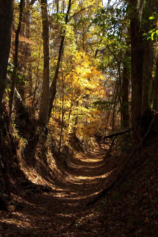
The Natchez Trace National Scenic Trail is five sections of hiking trail running roughly parallel to the 444-mile long Natchez Trace Parkway scenic motor road. The foot trails total more than 60 miles...

2 mi from route ~5 min detour Free near mile 204.7
Park Closure: Partial Closure of Rocky Springs Trail
Park Closure: Temporary Blackland Prairie Trail Closure to Equestrians
View on nps.gov
Tupelo National Battlefield

Tupelo National Battlefield

National Battlefield

In July, 1864, federal forces, including men from the United States Colored Troops, marched into Tupelo, Mississippi. Disorganized Confederate soldiers fought fiercely but could not overpower the fede...

4 mi from route ~10 min detour Free near mile 196.2
View on nps.gov
Medgar and Myrlie Evers Home National Monument

Medgar and Myrlie Evers Home National Monument

National Monument

Medgar and Myrlie Evers were partners in the civil rights struggle. The assassination of Medgar Evers in the carport of their home on June 12, 1963, was the first murder of a nationally significant le...

8 mi from route ~19 min detour Free
View on nps.gov

Park data from the National Park Service API. Alerts update every 2 hours.

Fuel & Cost

Regular Gas

$37.82 one way

$75.64 round trip

$3.88/gal 25.4 MPG avg 87 kg CO2
Fuel Type $/gal One Way Round Trip
midgrade $4.26 $41.48 $82.97
premium $4.61 $44.90 $89.80
diesel $5.64 $54.96 $109.93

No toll roads detected on this route.

Estimated Trip Cost (one way, 1 person)

Fuel

$38

Meals

$25–$50

Total

$63–$88

Rough estimate based on US averages. Hotel $80–$140/night, meals $25–$50/day.

Estimated CO2 emission: 86.6 kg one way. Prices: EIA weekly data, 2026-04-06.

EV Charging Along Route

29 DC fast chargers · Coverage: excellent

Sayle C-Store - Tesla Supercharger

Grenada, MS

Tesla

8 DCFC

The Mall at Barnes Crossing - Tesla Supercharger

Tupelo, MS

Tesla

8 DCFC

Shell - Tesla Supercharger

Corinth, MS

Tesla

8 DCFC

Pilot Travel Center 261

Winona, MS

eVgo Network

4 DCFC

Kirk Auto Company

Grenada, MS

FORD_CHARGE

4 DCFC

Electric Era Charging Station

Water Valley, MS

ELECTRIC_ERA

4 DCFC

Metro Ford Auto Sales

Tupelo, MS

FORD_CHARGE

4 DCFC

Mac Haik Jackson CDJR

Jackson, MS

EV Connect

2 DCFC

ChargePoint Network: 18 EV Connect: 4 Tesla: 3 FORD_CHARGE: 2 eVgo Network: 1 ELECTRIC_ERA: 1

Station data from NREL Alternative Fuel Stations database.

Driving Electric?

About $26 in charging · 0 stops · 67% less CO2

Vehicle Type kWh Stops DC Fast Home Charge
Average EV 74.2 0 $25.98 $11.88
Efficient EV 61.9 0 $21.65 $9.90
EV Truck/SUV 99 1 $34.64 $15.83

Gas CO2

87 kg

EV CO2

29 kg (67% less)

Plan for 0 charging stops, roughly every 270 miles. Allow 25-40 minutes per stop at a DC fast charger.

DC fast charging avg $0.35/kWh. Home charging avg $0.16/kWh. US grid CO2: 0.39 kg/kWh.

Travel Intel

Current conditions at both ends of the drive.

Forecast data refreshed 3 days ago

Origin

Ridgeland, MS

Morning in Ridgeland on Monday

Local time

8:00 AM

CDT

Current temp

65°F

Unavailable

Live forecast

Destination

Corinth, MS

Morning in Corinth on Monday

Local time

8:00 AM

CDT

Current temp

57°F

Unavailable

Live forecast

Seasonal Notes

Summer travel usually means heavier construction, hotter rest stops, and busier weekend traffic around major cities.

Winter travel shortens daylight, so a route that looks manageable on paper can feel much longer after dark.

Holiday weekends tend to make both departure and arrival windows slower than the raw route time suggests.

Time zone

Same local time

Origin and destination are on the same clock, so arrival timing is easier to judge at a glance.

Temperature spread

8 degrees cooler at arrival

A meaningful temperature swing is a good cue to rethink layers, water, and how soon you want to arrive.

Road read

4h 42m on the road

An early start around 7-8 AM gets you there with plenty of daylight left.

Weather data from the National Weather Service. Conditions may change; check closer to your travel date.

Frequently Asked Questions

The drive from Ridgeland, MS to Corinth, MS covers 247.4 miles and takes about 4h 42m without stops. Add 15-30 minutes for a fuel or rest stop on longer drives.
The main roads are I 55, US 45, MS 7. Most of the drive stays on highways, so watch for ramps and exits.
This is a comfortable same-day trip.
The midpoint is about 123.7 miles from Ridgeland, MS. Look for rest areas, gas stations, or food options near the halfway mark.
At current regular gas prices, expect to spend about $37.82 one way. This estimate uses 25.4 MPG — your actual cost will vary with your vehicle's fuel efficiency and current gas prices.
An early start around 7-8 AM gets you there with plenty of daylight left. A late afternoon start means arriving after dark. Morning is better.
Plan about 1 meaningful break for fuel, food, or rest. Plan on a short reset every 3 to 4 hours to stay fresh behind the wheel.
This is a demanding drive. With 19 significant decision points across 247.4 miles, you will need to stay alert — especially through interchange areas and urban stretches. Consider splitting it into segments if you are not comfortable with fast highway navigation.
The main spots that need attention: at 142.7 miles (MS 7): Roundabout - know your exit number before entering; at 180.4 miles: Exit ramp - move to the correct lane early. Multiple destination signs - pick the right one; at 180.8 miles: Highway fork - watch signs carefully.
On the drive from Ridgeland, MS to Corinth, MS, road signs begin pointing toward Sherman along the way.

Was this route helpful?

Thanks for your feedback!

Your tip has been submitted. Thanks!

/500

Explore More

Explore more options from Ridgeland, MS or browse trips ending in Corinth, MS.

Looking for more statewide routes? Browse MS road trips.

Explore maps for Ridgeland, MS or Corinth, MS on MapSof.net.