
Trip from Roanoke, VA to Carrollton, VA

Data updated 2 hours ago

Drive Time

4h 54m

Distance

225 mi

362 km

Drive Score

9/10

Great drive

Same Day?

Yes, doable

Fuel Cost

$35

one way

EV Charging

Loading...

station data

Best Time to Leave

Save up to 41 min
4 AM
4h 41m ★
6 AM
4h 55m
8 AM
5h 22m
10 AM
5h 4m
12 PM
5h 2m
3 PM
5h 6m
5 PM
5h 21m
8 PM
4h 47m

Estimated drive times based on typical traffic patterns. Actual times may vary with weather, construction, and real-time conditions.

independent city in Virginia, United States

Roanoke, VA

Wikimedia Commons

Downtown Carrollton, VA, VA

Carrollton, VA

Kelly

Trip Overview

The drive from Roanoke, VA to Carrollton, VA covers 225 miles and takes about 4h 54m behind the wheel. This route is realistic as a one-day drive if you keep your stops efficient.

The route leans on US 460, Patrick Henry Highway, West Lynchburg Salem Turnpike for much of the mileage, and the overall profile is mixed drive. The longest uninterrupted segment is about 79.8 miles on US 460. At current regular gas prices, budget about $35.19 one way before food or hotel costs.

Trip Pace

Same-day drive is realistic

A same-day return is possible, but it will make for a full day on the road.

Break Rhythm

1 planned break

Plan on a short reset every 3 to 4 hours to stay fresh behind the wheel.

Midpoint

112.5 miles from Roanoke, VA

A natural place for your longest stop of the day , about 2h 27m into the drive .

Loading map...

Drive Character

The drive from Roanoke, VA to Carrollton, VA covers 225 miles and takes about 4h 54m, using a mix of highways and local roads.

Expect a mix of faster highway mileage and slower local approaches near the beginning or end.
There are about 34 navigation steps in the underlying route data, so the final approach matters more than the middle miles.
US 460 is the longest continuous segment at about 79.8 miles.

How Hard Is This Drive?

This route mixes highway mileage with some local-road sections near the start or finish. This route has several spots where lane changes, forks, or exits need your full attention. The trickiest moment comes around 0.2 miles in near US 221; US 220 BUS / Franklin Road Southwest.

Route Complexity 8/10

Demanding - plan breaks and stay ahead of the key maneuvers

This is a demanding drive. With 19 significant decision points across 225 miles, you will need to stay alert — especially through interchange areas and urban stretches. Consider splitting it into segments if you are not comfortable with fast highway navigation.

Where does it get tricky?

The main spots that need attention: at 0.2 miles (US 221; US 220 BUS / Franklin Road Southwest): Sharp turn - reduce speed on approach; at 27 miles (US 460): Highway fork - watch signs carefully. Lane positioning matters here; at 148.1 miles: Highway fork - watch signs carefully. Lane positioning matters here.

Critical Maneuvers

5 of 19 key points

These are the spots where you need to pay the most attention. Preview them before you drive.

6
0.2 mi into trip | ~1m in | US 221; US 220 BUS / Franklin Road Southwest

Turn sharp left onto US 221; US 220 BUS / Franklin Road Southwest

Sharp turn - reduce speed on approach

7
27 mi into trip | ~40m in | US 460

Keep slight right at fork onto US 460 toward US 460 East

Highway fork - watch signs carefully. Lane positioning matters here

Use the straight lane. Toward US 460 East
8
148.1 mi into trip | ~3h 16m in

Keep slight right at fork toward VA 288 South

Highway fork - watch signs carefully. Lane positioning matters here

Use the slight right lane. Toward VA 288 South
7
160.5 mi into trip | ~3h 30m in

Keep slight right at fork toward I 95 South: Petersburg

Highway fork - watch signs carefully. Lane positioning matters here

Use the slight right lane. Toward I 95 South: Petersburg
7
162.3 mi into trip | ~3h 33m in

Take the exit toward VA 10 East: Hopewell

Exit ramp - move to the correct lane early. Lane positioning matters here

Use the right lane. Exit 61A Toward VA 10 East: Hopewell

Main Roads

Road Distance Duration
US 460 79.8 mi 1h 39m
Patrick Henry Highway 17.2 mi 21m
West Lynchburg Salem Turnpike 14.6 mi 18m
James River Drive 14.6 mi 19m
Hull Street Road 13.7 mi 19m
Colonial Trail West 13.3 mi 15m
World War II Veterans Memorial Highway 12.1 mi 14m
Old Stage Highway 12 mi 15m
Longest stretch: US 460 — 79.8 mi, about 1h 39m

Turn-by-Turn Driving Directions

Step-by-step road directions between Roanoke, VA and Carrollton, VA.

1

Start on this road

285 ft · 26 sec · this road
2

Turn left onto 1st Street Southwest

0.1 mi · 34 sec · 1st Street Southwest
3

Turn sharp left onto US 221; US 220 BUS

0.2 mi · 26 sec · Franklin Road Southwest
4

Turn left onto US 221; US 220 BUS; VA 116

0.2 mi · 35 sec · Williamson Road Southeast
5

Continue on US 11; US 221; US 220 BUS; VA 116

0.2 mi · 37 sec · Williamson Road Northeast
6

Turn right onto Kimball Avenue Northeast

0.7 mi · 1 min · Kimball Avenue Northeast
7

Turn right onto US 221; US 460; US 220 Alt

2.9 mi · 6 min · Orange Avenue Northeast
8

Continue on US 221; US 460; US 220 Alternate

1.9 mi · 3 min · Challenger Avenue Northeast
Use the straight lane.
9

Continue on US 221; US 460

5.5 mi · 7 min · Blue Ridge Boulevard
10

Continue on US 221; US 460

15 mi · 18 min · West Lynchburg Salem Turnpike
11

Continue on US 221; US 460

0.6 mi · 42 sec · Blue Ridge Avenue
12

Keep slight right at fork onto US 460

80 mi · 1 hr 39 min · US 460
Toward US 460 East Use the straight lane.
13

Turn left onto VA 307

9.3 mi · 12 min · Holly Farms Road
14

Turn left onto US 360

17 mi · 21 min · Patrick Henry Highway
15

Continue on US 360

14 mi · 19 min · Hull Street Road
Use the straight lane.
16

Turn right onto SR 754

0.9 mi · 1 min · Commonwealth Centre Parkway
Use the right lane.
17

Take the ramp

62 ft · 1 sec
18

Keep slight right at fork

0.3 mi · 40 sec
Toward VA 288 South Use the slight right lane.
19

Merge onto VA 288

12 mi · 14 min · World War II Veterans Memorial Highway
20

Keep slight right at fork

0.3 mi · 37 sec
Toward I 95 South: Petersburg Use the slight right lane.
21

Merge onto I 95

1.5 mi · 1 min · Richmond-Petersburg Turnpike
22

Take the exit

0.3 mi · 38 sec
Exit 61A Toward VA 10 East: Hopewell Use the right lane.
23

Continue on VA 10

6.8 mi · 10 min · West Hundred Road
Use the left / uturn lanes.
24

Continue on VA 10

2.9 mi · 4 min · West Randolph Road
25

Continue on VA 10; VA 156 BUS

15 mi · 19 min · James River Drive
26

Continue on VA 10

13 mi · 15 min · Colonial Trail West
27

At end of road, turn left onto VA 10; VA 31

1.0 mi · 1 min · Rolfe Highway
28

Take the exit

149 ft · 6 sec
29

Merge onto VA 10

9.8 mi · 11 min · Colonial Trail East
30

Continue on VA 10

12 mi · 15 min · Old Stage Highway
Use the left lane.
31

Keep slight left at fork onto US 258

1.0 mi · 1 min · Brewers Neck Boulevard
32

Turn left onto SR 665

0.8 mi · 1 min · Reynolds Drive
Use the left lane.
33

Turn right onto SR 670

178 ft · 3 sec · Norsworthy Drive
34

Arrive at destination

SR 670

Trip Plan

Morning Departure

An early start around 7-8 AM gets you there with plenty of daylight left.

Evening Departure

A late afternoon start means arriving after dark. Morning is better.

You can normally do this drive in one day.
Plan roughly 1 meaningful break for fuel, food, and rest.
The halfway point lands around 112.5 miles from Roanoke, VA, or about 2h 27m into the drive.
The longest continuous stretch on this route runs about 79.8 miles.

This is a comfortable same-day trip.

Departure

Before you leave

Start with fuel, water, and navigation already sorted so the first hour feels easy.

First stop

Around 80 miles or 1h 46m in

Use this first pause for coffee, a restroom break, and a quick traffic check ahead.

Halfway reset

Around 112.5 miles or 2h 27m in

This is the best place for your longest stop, a real meal, and a full fuel check.

Final approach

Final hour starts around 4h 4m

Traffic, exits, and arrival timing usually matter more near Carrollton, VA than in the middle of the route.

Before You Leave

+

Open the route before leaving Roanoke, VA so your first major turns are already loaded.

+

Leave with enough water and a charging cable within reach, not packed away.

+

Check your fuel range against the first long segment, especially if you are starting outside city service areas.

Day 1

Settle into the route from Roanoke, VA

This is one driving day of about 225 miles and 4h 54m.

Your first comfortable stop window is around 80 miles from Roanoke, VA.
This route can stay practical as a one-day drive if traffic stays reasonable.
Plan about 1 real break rather than only quick fuel stops.
The longest stretch is on US 460 for about 79.8 miles.

Where to Stop

Rest stops, refuel points, and overnight suggestions along this route.

Halfway Point

Midpoint

About 112.5 mi from Roanoke, VA · 2h 27m into the drive

Downtown Middletown, MD, MD

Mid-route town

Meal stop

Middletown, MD

113 mi into the route

Best for: Lunch, fuel, and a longer reset

This sits close to the middle of the route, so it works well for the longest stop of the day.

Pacing Suggestions

Middletown, MD

Fuel and coffee

A short stop after about 80 miles helps settle the day before fatigue starts building.

Middletown, MD

Meal break

The midpoint is around 112.5 miles from Roanoke, VA, which is a good place for a longer meal and fuel stop.

Arriving in Carrollton, VA

The final approach into Carrollton, VA usually feels slower than the middle of the drive, so avoid planning your tightest schedule at the very end.

Try to arrive with enough fuel left to skip an immediate station stop unless you already know the area around Carrollton, VA.

These stop ideas are pacing suggestions — the exact town or exit can change with traffic, hotel plans, and fuel range.

National Parks Near This Route

Worth a detour if your schedule allows.

Appomattox Court House National Historical Park

Appomattox Court House National Historical Park

National Historical Park

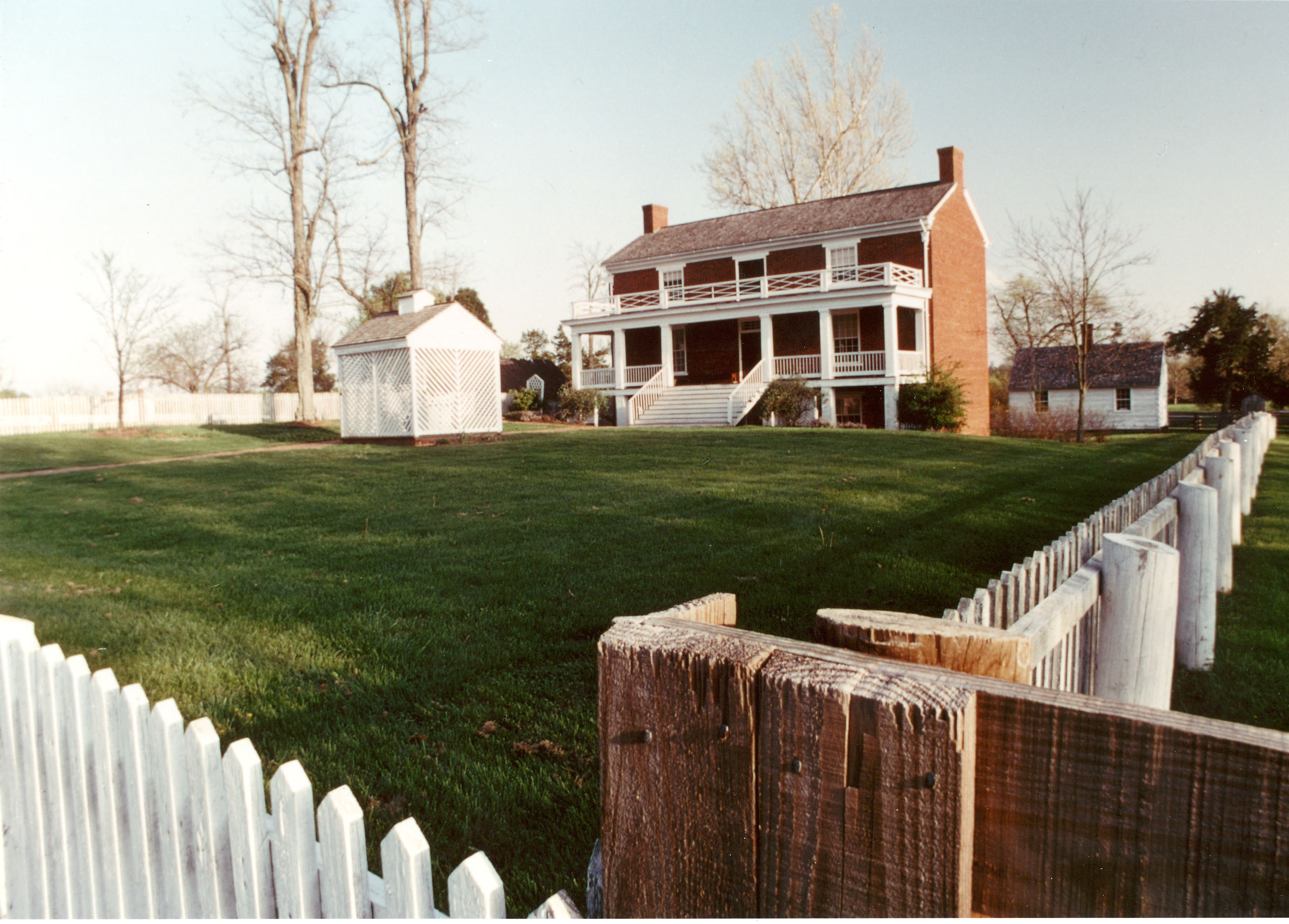
On April 9, 1865, the surrender of the Army of Northern Virginia in the McLean House in the village of Appomattox Court House, Virginia signaled the effective end of the nation's largest war. Question...

3 mi from route ~8 min detour Free near mile 69.8
View on nps.gov
Colonial National Historical Park

Colonial National Historical Park

National Historical Park

On May 13, 1607, Jamestown was established as the first permanent English settlement in North America. Three cultures came together – European, Virginia Indian and African–to create a new society that...

11 mi from route ~28 min detour $15 near mile 209.5
View on nps.gov
Petersburg National Battlefield

Petersburg National Battlefield

National Battlefield

Two hundred ninety-two days, eight offensives, over 70,000 casualties, U. S. Colored Troops, and the decline of Gen. Lee's Army of Northern Virginia all describe the Siege of Petersburg. U.S. forces c...

12 mi from route ~30 min detour Free near mile 162.9
View on nps.gov
Fort Monroe National Monument

Fort Monroe National Monument

National Monument

Fort Monroe's story spans from prehistory to the 2000s. Kecoughtan Indians occupied Old Point Comfort before the arrival of English colonists. The first enslaved Africans arrived in 1619. Those escapi...

15 mi from route ~38 min detour Free near mile 225
View on nps.gov
Booker T Washington National Monument

Booker T Washington National Monument

National Monument

Booker T. Washington was born a slave in April 1856 on the 207-acre farm of James Burroughs. After the Civil War, Washington became the first principal of Tuskegee Normal and Industrial School. Later...

16 mi from route ~39 min detour Free
View on nps.gov

Park data from the National Park Service API. Alerts update every 2 hours.

Fuel & Cost

Regular Gas

$35.19 one way

$70.37 round trip

$3.97/gal 25.4 MPG avg 79 kg CO2
Fuel Type $/gal One Way Round Trip
midgrade $4.34 $38.47 $76.94
premium $4.70 $41.64 $83.29
diesel $5.61 $49.68 $99.35

Estimated Tolls: $1.12

West Lynchburg Salem Turnpike (14.6 mi) $1.02
Richmond-Petersburg Turnpike (1.5 mi) $0.10

Toll estimates based on average 2024-2025 rates. EZ-Pass/SunPass discounts may lower the actual cost.

Estimated Trip Cost (one way, 1 person)

Fuel

$35

Tolls

$1

Meals

$25–$50

Total

$61–$86

Rough estimate based on US averages. Hotel $80–$140/night, meals $25–$50/day.

Estimated CO2 emission: 78.7 kg one way. Prices: EIA weekly data, 2026-04-13.

Driving Electric?

About $24 in charging · 0 stops · 67% less CO2

Vehicle Type kWh Stops DC Fast Home Charge
Average EV 67.5 0 $23.63 $10.80
Efficient EV 56.3 0 $19.69 $9.00
EV Truck/SUV 90 1 $31.50 $14.40

Gas CO2

79 kg

EV CO2

26 kg (67% less)

Plan for 0 charging stops, roughly every 270 miles. Allow 25-40 minutes per stop at a DC fast charger.

DC fast charging avg $0.35/kWh. Home charging avg $0.16/kWh. US grid CO2: 0.39 kg/kWh.

Travel Intel

Current conditions at both ends of the drive.

Forecast data refreshed 1 day ago

Origin

Roanoke, VA

Evening in Roanoke on Tuesday

Local time

8:51 PM

EDT

Current temp

44°F

Unavailable

Live forecast

Destination

Carrollton, VA

Evening in Carrollton on Tuesday

Local time

8:51 PM

EDT

Current temp

87°F

Unavailable

Live forecast

86°F

Middletown, MD

113 mi in

Seasonal Notes

Summer travel usually means heavier construction, hotter rest stops, and busier weekend traffic around major cities.

Winter travel shortens daylight, so a route that looks manageable on paper can feel much longer after dark.

Holiday weekends tend to make both departure and arrival windows slower than the raw route time suggests.

Time zone

Same local time

Origin and destination are on the same clock, so arrival timing is easier to judge at a glance.

Temperature spread

43 degrees warmer at arrival

A meaningful temperature swing is a good cue to rethink layers, water, and how soon you want to arrive.

Road read

4h 54m on the road

An early start around 7-8 AM gets you there with plenty of daylight left.

Weather data from the National Weather Service. Conditions may change; check closer to your travel date.

Frequently Asked Questions

The drive from Roanoke, VA to Carrollton, VA covers 225 miles and takes about 4h 54m without stops. Add 15-30 minutes for a fuel or rest stop on longer drives.
The main roads are US 460, Patrick Henry Highway, West Lynchburg Salem Turnpike. Expect a mix of highway and local road driving.
This is a comfortable same-day trip.
The midpoint is about 112.5 miles from Roanoke, VA. Look for rest areas, gas stations, or food options near the halfway mark.
At current regular gas prices, expect to spend about $35.19 one way. This estimate uses 25.4 MPG — your actual cost will vary with your vehicle's fuel efficiency and current gas prices.
An early start around 7-8 AM gets you there with plenty of daylight left. A late afternoon start means arriving after dark. Morning is better.
Plan about 1 meaningful break for fuel, food, or rest. Plan on a short reset every 3 to 4 hours to stay fresh behind the wheel.
This is a demanding drive. With 19 significant decision points across 225 miles, you will need to stay alert — especially through interchange areas and urban stretches. Consider splitting it into segments if you are not comfortable with fast highway navigation.
The main spots that need attention: at 0.2 miles (US 221; US 220 BUS / Franklin Road Southwest): Sharp turn - reduce speed on approach; at 27 miles (US 460): Highway fork - watch signs carefully. Lane positioning matters here; at 148.1 miles: Highway fork - watch signs carefully. Lane positioning matters here.
The route from Roanoke, VA to Carrollton, VA does not surface many named destination signs beyond the main corridor.

Was this route helpful?

Thanks for your feedback!

Your tip has been submitted. Thanks!

/500

Explore More

Return Trip

Carrollton, VA to Roanoke, VA

Plan the drive back the other way.

227.9 mi 4h 51m

Explore more options from Roanoke, VA or browse trips ending in Carrollton, VA.

Looking for more statewide routes? Browse VA road trips.

Explore maps for Roanoke, VA or Carrollton, VA on MapSof.net.