The drive from Rogue River, OR to Bend, OR covers 181.4 miles and takes about 4h 10m behind the wheel.
This route is realistic as a one-day drive if you keep your stops efficient.
The route leans on The Dalles-California Highway, Crater Lake Highway, Diamond Lake Highway for much of the mileage,
and the overall profile is turn-heavy local drive.
The longest uninterrupted segment is about 71.2 miles on The Dalles-California Highway.
At current regular gas prices, budget about $36.14 one way before food or hotel costs.
Trip Pace
Same-day drive is realistic
A same-day return is possible, but it will make for a full day on the road.
Break Rhythm
1 planned break
Plan on a short reset every 3 to 4 hours to stay fresh behind the wheel.
Midpoint
90.7 miles from Rogue River, OR
A natural place for your longest stop of the day
, about 2h 12m into the drive
.
Who Is This Route For?
Weekend Trip
Doable as a same-day drive at 4h 10m. Total distance: 181.4 miles.
Family Friendly
Moderate complexity with 1 natural rest stops along the way.
Turn-heavy local drive route profile with national parks nearby.
Drive Character
Expect a 4h 10m drive with frequent turns across 181.4 miles of local and secondary roads.
This route has more turning and local-road decision points than a simple highway run.
There are about 28 navigation steps in the underlying route data, so the final approach matters more than the middle miles.
The Dalles-California Highway is the longest continuous segment at about 71.2 miles.
How Hard Is This Drive?
Expect a hands-on drive with frequent turns and local roads rather than long highway stretches. There are only a few real navigation decisions along the way. The trickiest moment comes around 5.1 miles in.
Driving Effort3/10
Easy - simple navigation with a manageable amount of wheel time
Balances navigation complexity with total wheel time.
This is a straightforward 4h 10m drive. You will face about 17 decision points, but nothing that requires special attention if you follow navigation.
Where does it get tricky?
The main spots that need attention: at 5.1 miles: Exit ramp - move to the correct lane early. Multiple destination signs - pick the right one; at 23.3 miles (OR 62 / Crater Lake Highway): Lane positioning matters here; at 88.5 miles (OR 138 / North Umpqua Highway): Navigation decision point.
Critical Maneuvers
5 of 17 key points
These are the spots where you need to pay the most attention. Preview them before you drive.
5
5.1 mi into trip|~6m in
Take the exit toward OR 99, OR 234: Gold Hill, Crater Lake
Exit ramp - move to the correct lane early. Multiple destination signs - pick the right one
Toward OR 99, OR 234: Gold Hill, Crater Lake
6
23.3 mi into trip|~34m in|OR 62 / Crater Lake Highway
Turn left onto OR 62 / Crater Lake Highway
Lane positioning matters here
Use the straight lane.
5
88.5 mi into trip|~2h 8m in|OR 138 / North Umpqua Highway
At end of road, turn right onto OR 138 / North Umpqua Highway
Navigation decision point
5
180.4 mi into trip|~4h 7m in
Take the exit toward Downtown Bend, Mount Bachelor
Exit ramp - move to the correct lane early. Multiple destination signs - pick the right one
Toward Downtown Bend, Mount Bachelor
5
180.6 mi into trip|~4h 7m in|Southeast Scott Street
At end of road, turn right onto Southeast Scott Street
Navigation decision point
Main Roads
Road
Distance
Duration
The Dalles-California Highway
71.2 mi
1h 28m
Crater Lake Highway
41.4 mi
59m
Diamond Lake Highway
23.8 mi
35m
State Highway 234
10.7 mi
14m
East Diamond Lake Highway
8.4 mi
11m
State Highway 138
6.3 mi
8m
Sams Valley Highway
5.2 mi
7m
I 5
4.5 mi
5m
Longest stretch:
The Dalles-California Highway
— 71.2 mi, about 1h 28m
Turn-by-Turn Driving Directions
Step-by-step road directions between Rogue River, OR and Bend, OR.
1
Start on Berglund Street
520 ft·24 sec·Berglund Street
2
Turn left onto West Main Street
418 ft·8 sec·West Main Street
3
Turn slight right onto Pine Street
485 ft·11 sec·Pine Street
4
Turn right onto Depot Street
404 ft·13 sec·Depot Street
5
Take the ramp
0.3 mi·37 sec
6
Merge onto I 5
4.5 mi·5 min·I 5
7
Take the exit
0.2 mi·27 sec
Toward OR 99, OR 234: Gold Hill, Crater Lake
8
Turn left onto OR 234
0.2 mi·18 sec·Main Street
9
At end of road, turn right onto OR 99; OR 234
1.0 mi·1 min·Sams Valley Highway
10
Continue on OR 99; OR 234
1.6 mi·3 min·2nd Avenue
11
Turn left onto OR 234
391 ft·15 sec·Dardanelles Street
12
Turn right onto OR 234
0.2 mi·33 sec·4th Avenue
13
Continue on OR 234
4.2 mi·6 min·Sams Valley Highway
14
Continue on OR 234
11 mi·14 min·State Highway 234
15
Turn left onto OR 62
41 mi·59 min·Crater Lake Highway
Use the straight lane.
16
Turn straight onto OR 230
24 mi·35 min·Diamond Lake Highway
17
At end of road, turn right onto OR 138
2.9 mi·4 min·North Umpqua Highway
18
Keep slight left at fork onto OR 138
216 ft·3 sec·North Umpqua Highway
19
Continue on OR 138
8.4 mi·11 min·East Diamond Lake Highway
20
Continue on OR 138
6.3 mi·8 min·State Highway 138
21
Turn left onto US 97
71 mi·1 hr 28 min·The Dalles-California Highway
22
Continue on US 97
3.0 mi·5 min·Bend Parkway
23
Take the exit
0.2 mi·21 sec
Toward Downtown Bend, Mount Bachelor
24
At end of road, turn right onto Southeast Scott Street
238 ft·5 sec·Southeast Scott Street
25
Continue on Northwest Colorado Avenue
0.2 mi·33 sec·Northwest Colorado Avenue
26
Turn right onto Northwest Sisemore Street
0.3 mi·55 sec·Northwest Sisemore Street
27
Turn left onto Northwest Franklin Avenue
0.3 mi·1 min·Northwest Franklin Avenue
28
Arrive at destination
Northwest Franklin Avenue
Trip Plan
Morning Departure
An early start around 7-8 AM gets you there with plenty of daylight left.
Evening Departure
A late afternoon start means arriving after dark. Morning is better.
You can normally do this drive in one day.
Plan roughly 1 meaningful break for fuel, food, and rest.
The halfway point lands around 90.7 miles from Rogue River, OR, or about 2h 12m into the drive.
The longest continuous stretch on this route runs about 71.2 miles.
This is a comfortable same-day trip.
Departure
Before you leave
Start with fuel, water, and navigation already sorted so the first hour feels easy.
First stop
Around 40 miles or 57m in
Use this first pause for coffee, a restroom break, and a quick traffic check ahead.
Halfway reset
Around 90.7 miles or 2h 12m in
This is the best place for your longest stop, a real meal, and a full fuel check.
Final approach
Final hour starts around 3h 26m
Traffic, exits, and arrival timing usually matter more near Bend, OR than in the middle of the route.
Before You Leave
+
Open the route before leaving Rogue River, OR so your first major turns are already loaded.
+
Leave with enough water and a charging cable within reach, not packed away.
+
Check your fuel range against the first long segment, especially if you are starting outside city service areas.
Day 1
Settle into the route from Rogue River, OR
This is one driving day of about 181.4 miles and 4h 10m.
Your first comfortable stop window is around 40 miles from Rogue River, OR.
This route can stay practical as a one-day drive if traffic stays reasonable.
Plan about 1 real break rather than only quick fuel stops.
The longest stretch is on The Dalles-California Highway for about 71.2 miles.
Where to Stop
Rest stops, refuel points, and overnight suggestions along this route.
Halfway Point
Midpoint
About 90.7 mi from Rogue River, OR
· 2h 12m into the drive
The midpoint is around 90.7 miles from Rogue River, OR, which is a good place for a longer meal and fuel stop.
Before the longest stretch
Fuel check
Top up before The Dalles-California Highway if your tank is already low. That segment runs about 71.2 miles.
Arriving in Bend, OR
The final approach into Bend, OR usually feels slower than the middle of the drive, so avoid planning your tightest schedule at the very end.
Try to arrive with enough fuel left to skip an immediate station stop unless you already know the area around Bend, OR.
These stop ideas are pacing suggestions — the exact town or exit can change with traffic, hotel plans, and fuel range.
National Parks Near This Route
Worth a detour if your schedule allows.
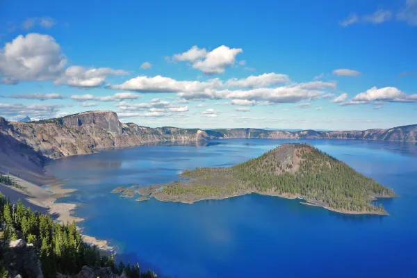
Crater Lake National Park
National Park
Crater Lake inspires awe. Native Americans witnessed its formation 7,700 years ago, when a violent eruption triggered the collapse of a tall peak. Scientists marvel at its purity—fed by rain and snow,...
11 mi from route
~27 min detour
$30
near mile 93.8
Park Closure: Road to Rim Village is Temporarily CLOSED Due to Incoming Snowstorm
Park Closure: Cleetwood Cove Trail is CLOSED for Rehabilitation
Park data from the National Park Service API. Alerts update every 2 hours.
Fuel & Cost
Regular Gas
$36.14 one way
$72.27 round trip
$5.06/gal25.4 MPG avg64 kg CO2
Fuel Type
$/gal
One Way
Round Trip
midgrade
$5.36
$38.24
$76.49
premium
$5.59
$39.93
$79.86
diesel
$5.61
$40.05
$80.10
No toll roads detected on this route.
Estimated Trip Cost (one way, 1 person)
Fuel
$36
Meals
$25–$50
Total
$61–$86
Rough estimate based on US averages. Hotel $80–$140/night, meals $25–$50/day.
Estimated CO2 emission: 63.5 kg one way.
Prices: EIA weekly data, 2026-04-13.
Driving Electric?
About $19 in charging
· 0 stops
· 67% less CO2
Vehicle Type
kWh
Stops
DC Fast
Home Charge
Average EV
54.4
0
$19.05
$8.71
Efficient EV
45.4
0
$15.87
$7.26
EV Truck/SUV
72.6
0
$25.40
$11.61
Gas CO2
63 kg
EV CO2
21 kg (67% less)
This trip is well within single-charge range for most EVs. No charging stops needed if you start fully charged.
DC fast charging avg $0.35/kWh. Home charging avg $0.16/kWh. US grid CO2: 0.39 kg/kWh.
Travel Intel
Current conditions at both ends of the drive.
Forecast as of Apr 15, 2026
Origin
Rogue River, OR
Late night
in Rogue River on Friday
Local time
5:07 AM
PDT
Current temp
55°F
Unavailable
Live forecast
Destination
Bend, OR
Late night
in Bend on Friday
Local time
5:07 AM
PDT
Current temp
35°F
Unavailable
Live forecast
Seasonal Notes
Summer travel usually means heavier construction, hotter rest stops, and busier weekend traffic around major cities.
Winter travel shortens daylight, so a route that looks manageable on paper can feel much longer after dark.
Holiday weekends tend to make both departure and arrival windows slower than the raw route time suggests.
Time zone
Same local time
Origin and destination are on the same clock, so arrival timing is easier to judge at a glance.
Temperature spread
20 degrees cooler at arrival
A meaningful temperature swing is a good cue to rethink layers, water, and how soon you want to arrive.
Road read
4h 10m on the road
An early start around 7-8 AM gets you there with plenty of daylight left.
Weather data from the National Weather Service. Conditions may change; check closer to your travel date.
Frequently Asked Questions
The drive from Rogue River, OR to Bend, OR covers 181.4 miles and takes about 4h 10m without stops. Add 15-30 minutes for a fuel or rest stop on longer drives.
The main roads are The Dalles-California Highway, Crater Lake Highway, Diamond Lake Highway. Expect a mix of highway and local road driving.
This is a comfortable same-day trip.
The midpoint is about 90.7 miles from Rogue River, OR. Look for rest areas, gas stations, or food options near the halfway mark.
At current regular gas prices, expect to spend about $36.14 one way. This estimate uses 25.4 MPG — your actual cost will vary with your vehicle's fuel efficiency and current gas prices.
An early start around 7-8 AM gets you there with plenty of daylight left. A late afternoon start means arriving after dark. Morning is better.
Plan about 1 meaningful break for fuel, food, or rest. Plan on a short reset every 3 to 4 hours to stay fresh behind the wheel.
This is a straightforward 4h 10m drive. You will face about 17 decision points, but nothing that requires special attention if you follow navigation.
The main spots that need attention: at 5.1 miles: Exit ramp - move to the correct lane early. Multiple destination signs - pick the right one; at 23.3 miles (OR 62 / Crater Lake Highway): Lane positioning matters here; at 88.5 miles (OR 138 / North Umpqua Highway): Navigation decision point.
The route from Rogue River, OR to Bend, OR does not surface many named destination signs beyond the main corridor.
Yes. Nearby national parks include Crater Lake National Park.
How this page is built
Compiled and maintained by the Trip.ovh planning team at COD Solutions Oy (Helsinki). Each route is built from authoritative open government and mapping datasets rather than crowdsourced reviews. Distances and geometry come from
OSRM
over
OpenStreetMap.
Fuel cost uses
EIA
weekly regional averages.
National park proximity is from the
NPS API.
Pages are published only after passing our data-quality checks; our
methodology page
documents refresh cadence, editorial standards, and known limitations.