
Trip from Sacramento, CA to Oakhurst, CA

Last recalculated Apr 17, 2026

Drive Time

3h 45m

Distance

177 mi

285 km

Drive Score

8/10

Great drive

Same Day?

Yes, doable

Fuel Cost

$41

one way

EV Charging

Unknown

Best Time to Leave

Save up to 38 min
4 AM
3h 33m ★
6 AM
3h 45m
8 AM
4h 11m
10 AM
3h 54m
12 PM
3h 52m
3 PM
3h 56m
5 PM
4h 10m
8 PM
3h 38m

Estimated drive times based on typical traffic patterns. Actual times may vary with weather, construction, and real-time conditions.

capital city of the U.S. state of California and seat of Sacramento County

Sacramento, CA

Wikimedia Commons

census-designated place (CDP) in Madera County, California, United States

Oakhurst, CA

Wikimedia Commons

Trip Overview

The drive from Sacramento, CA to Oakhurst, CA covers 177 miles and takes about 3h 45m behind the wheel. This route is realistic as a one-day drive if you keep your stops efficient.

The route leans on South Sacramento Freeway, CA 99, Yosemite Parkway for much of the mileage, and the overall profile is highway-focused drive. The longest uninterrupted segment is about 56.4 miles on South Sacramento Freeway. At current regular gas prices, budget about $40.68 one way before food or hotel costs.

Trip Pace

Same-day drive is realistic

A same-day return is realistic if you keep stops short.

Break Rhythm

1 planned break

A short stop every 2 to 3 hours is enough for this drive.

Midpoint

88.5 miles from Sacramento, CA

A natural place for your longest stop of the day , about 1h 43m into the drive .

Who Is This Route For?

Weekend Trip

Doable as a same-day drive at 3h 45m. Total distance: 177 miles.

Family Friendly

Moderate complexity with 1 natural rest stops along the way.

Solo Traveler

3h 45m drive, comfortable solo distance.

First-Time Driver

Mostly highway driving (83%). Some complex stretches to watch for.

Drive Character

This is a 3h 45m highway drive covering 177 miles, with most of the trip on South Sacramento Freeway and CA 99. The longest continuous stretch is about 56.4 miles on South Sacramento Freeway.

Most of the miles stay on highways, which makes pacing and fuel planning easier than turn-by-turn city driving.
There are about 20 navigation steps in the underlying route data, so the final approach matters more than the middle miles.
South Sacramento Freeway is the longest continuous segment at about 56.4 miles.

How Hard Is This Drive?

This is a straightforward highway drive that stays mostly on South Sacramento Freeway and CA 99. You will hit about 15 points where you need to pay attention to lane position or signs. The trickiest moment comes around 0.5 miles in near 15th Street.

Driving Effort 6/10

Moderate - straightforward overall, but long enough or busy enough to require pacing

Balances navigation complexity with total wheel time.

This drive requires moderate attention. Across 177 miles you will encounter 15 spots where lane choice or exit timing matters. Not difficult for experienced highway drivers, but worth previewing the tricky sections before you go.

Where does it get tricky?

The main spots that need attention: at 0.5 miles (15th Street): Lane positioning matters here; at 1.7 miles: Multiple destination signs - pick the right one; at 2.3 miles (I 80 Business / Capital City Freeway): Highway fork - watch signs carefully. Lane positioning matters here. Multiple destination signs - pick the right one.

Critical Maneuvers

5 of 15 key points

These are the spots where you need to pay the most attention. Preview them before you drive.

5
0.5 mi into trip | ~1m in | 15th Street

Turn right onto 15th Street

Lane positioning matters here

Use the straight / right lanes.
5
1.7 mi into trip | ~3m in

Take the ramp toward I 80 East, CA 99 South: Reno, Placerville, Fresno

Multiple destination signs - pick the right one

Toward I 80 East, CA 99 South: Reno, Placervill...
8
2.3 mi into trip | ~4m in | I 80 Business / Capital City Freeway

Keep slight right at fork onto I 80 Business / Capital City Freeway toward I 80 Business East, CA 99 South: Reno, Fresno

Highway fork - watch signs carefully. Lane positioning matters here. Multiple destination signs - pick the right one

Use the slight right lane. Toward I 80 Business East, CA 99 South: Reno, F...
6
2.6 mi into trip | ~4m in

Take the exit toward CA 99 South: Fresno

Exit ramp - move to the correct lane early. Lane positioning matters here

Use the straight / slight right lanes. Toward CA 99 South: Fresno
5
3 mi into trip | ~5m in | CA 99 / South Sacramento Freeway

Merge onto CA 99 / South Sacramento Freeway

Merge point - match speed before joining. Lane positioning matters here

Use the straight / slight right lanes.

Towns Mentioned on Route Signs

Based on OSRM destination-sign hints, not a full list of every settlement the road passes.

On the drive from Sacramento, CA to Oakhurst, CA, road signs begin pointing toward Yosemite along the way.

Yosemite

114.1 mi in | ~2h 13m | via CA 140

Main Roads

Road Distance Duration
South Sacramento Freeway 56.4 mi 1h 5m
CA 99 54.6 mi 1h 2m
Yosemite Parkway 35.7 mi 50m
Golden Chain Highway 16.6 mi 24m
Boot Jack Road 9.6 mi 14m
15th Street 1.1 mi 2m
Capital City Freeway 0.6 mi <1m
J Street 0.5 mi <1m
Longest stretch: South Sacramento Freeway — 56.4 mi, about 1h 5m

Turn-by-Turn Driving Directions

Step-by-step road directions between Sacramento, CA and Oakhurst, CA.

1

Start on 9th Street

348 ft · 16 sec · 9th Street
2

Turn left onto J Street

0.5 mi · 55 sec · J Street
3

Turn right onto 15th Street

1.1 mi · 2 min · 15th Street
Use the straight / right lanes.
4

Turn left onto X Street

400 ft · 8 sec · X Street
5

Take the ramp

0.2 mi · 31 sec
Toward I 80 East, CA 99 South: Reno, Placerville, Fresno
6

Merge onto US 50; I 80 Business

0.4 mi · 22 sec · Capital City Freeway
7

Keep slight right at fork onto I 80 Business

0.3 mi · 18 sec · Capital City Freeway
Toward I 80 Business East, CA 99 South: Reno, Fresno Use the slight right lane.
8

Take the exit

0.4 mi · 34 sec
Toward CA 99 South: Fresno Use the straight / slight right lanes.
9

Merge onto CA 99

56 mi · 1 hr 5 min · South Sacramento Freeway
Use the straight / slight right lanes.
10

Keep slight left at fork onto CA 99

55 mi · 1 hr 2 min · CA 99
11

Take the exit onto CA 140

0.2 mi · 33 sec · CA 140
Toward CA 140 East: Mariposa, Yosemite
12

Continue on CA 140

36 mi · 50 min · Yosemite Parkway
13

Turn right

75 ft · 2 sec
14

Turn right onto CA 49

17 mi · 24 min · Golden Chain Highway
15

Continue on CA 49

9.6 mi · 14 min · Boot Jack Road
16

At end of road, turn left onto CA 41

0.3 mi · 49 sec · Southern Yosemite Highway
17

Turn right onto 426

0.4 mi · 53 sec · Road 426
18

Turn slight right onto Road 425B

161 ft · 8 sec · Road 425B
19

Turn right onto Chapel Hill Drive

96 ft · 4 sec · Chapel Hill Drive
20

Arrive at destination

Chapel Hill Drive

Trip Plan

Morning Departure

An early start around 7-8 AM gets you there with plenty of daylight left.

Evening Departure

A late afternoon start means arriving after dark. Morning is better.

You can normally do this drive in one day.
Plan roughly 1 meaningful break for fuel, food, and rest.
The halfway point lands around 88.5 miles from Sacramento, CA, or about 1h 43m into the drive.
The longest continuous stretch on this route runs about 56.4 miles.

This is a comfortable same-day trip.

Departure

Before you leave

Start with fuel, water, and navigation already sorted so the first hour feels easy.

First stop

Around 39 miles or 46m in

Use this first pause for coffee, a restroom break, and a quick traffic check ahead.

Halfway reset

Around 88.5 miles or 1h 43m in

This is the best place for your longest stop, a real meal, and a full fuel check.

Final approach

Final hour starts around 2h 57m

Traffic, exits, and arrival timing usually matter more near Oakhurst, CA than in the middle of the route.

Before You Leave

+

Open the route before leaving Sacramento, CA so your first major turns are already loaded.

+

Leave with enough water and a charging cable within reach, not packed away.

+

Check your fuel range against the first long segment, especially if you are starting outside city service areas.

Day 1

Settle into the route from Sacramento, CA

This is one driving day of about 177 miles and 3h 45m.

Your first comfortable stop window is around 39 miles from Sacramento, CA.
This route can stay practical as a one-day drive if traffic stays reasonable.
Plan about 1 real break rather than only quick fuel stops.
The longest stretch is on South Sacramento Freeway for about 56.4 miles.

Where to Stop

Rest stops, refuel points, and overnight suggestions along this route.

Halfway Point

Midpoint

About 88.5 mi from Sacramento, CA · 1h 43m into the drive

city in and county seat of Merced County, California, United States

Mid-route town

Meal stop

Merced, CA

89 mi into the route

Best for: Lunch, fuel, and a longer reset

This sits close to the middle of the route, so it works well for the longest stop of the day.

Pacing Suggestions

Woodlake, CA

Fuel and coffee

A short stop after about 39 miles helps settle the day before fatigue starts building.

Turlock, CA

Meal break

The midpoint is around 88.5 miles from Sacramento, CA, which is a good place for a longer meal and fuel stop.

Arriving in Oakhurst, CA

The final approach into Oakhurst, CA usually feels slower than the middle of the drive, so avoid planning your tightest schedule at the very end.

Try to arrive with enough fuel left to skip an immediate station stop unless you already know the area around Oakhurst, CA.

These stop ideas are pacing suggestions — the exact town or exit can change with traffic, hotel plans, and fuel range.

National Parks Near This Route

Worth a detour if your schedule allows.

Yosemite National Park

Yosemite National Park

National Park

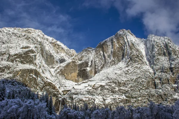
Not just a great valley, but a shrine to human foresight, the strength of granite, the power of glaciers, the persistence of life, and the tranquility of the High Sierra. First protected in 1864, Yose...

30 mi from route ~75 min detour $35 near mile 164.8
View on nps.gov

Park data from the National Park Service API. Alerts update every 2 hours.

Fuel & Cost

Regular Gas

$40.68 one way

$81.36 round trip

$5.84/gal 25.4 MPG avg 62 kg CO2
Fuel Type $/gal One Way Round Trip
midgrade $6.02 $41.92 $83.85
premium $6.18 $43.04 $86.09
diesel $5.61 $39.08 $78.16

No toll roads detected on this route.

Estimated Trip Cost (one way, 1 person)

Fuel

$41

Meals

$25–$50

Total

$66–$91

Rough estimate based on US averages. Hotel $80–$140/night, meals $25–$50/day.

Estimated CO2 emission: 61.9 kg one way. Prices: EIA weekly data, 2026-04-13.

Driving Electric?

About $19 in charging · 0 stops · 66% less CO2

Vehicle Type kWh Stops DC Fast Home Charge
Average EV 53.1 0 $18.59 $8.50
Efficient EV 44.3 0 $15.49 $7.08
EV Truck/SUV 70.8 0 $24.78 $11.33

Gas CO2

62 kg

EV CO2

21 kg (66% less)

This trip is well within single-charge range for most EVs. No charging stops needed if you start fully charged.

DC fast charging avg $0.35/kWh. Home charging avg $0.16/kWh. US grid CO2: 0.39 kg/kWh.

Travel Intel

Current conditions at both ends of the drive.

Forecast as of Apr 15, 2026

Origin

Sacramento, CA

Evening in Sacramento on Thursday

Local time

8:09 PM

PDT

Current temp

68°F

Unavailable

Live forecast

Destination

Oakhurst, CA

Evening in Oakhurst on Thursday

Local time

8:09 PM

PDT

Current temp

39°F

Unavailable

Live forecast

Seasonal Notes

Summer travel usually means heavier construction, hotter rest stops, and busier weekend traffic around major cities.

Winter travel shortens daylight, so a route that looks manageable on paper can feel much longer after dark.

Holiday weekends tend to make both departure and arrival windows slower than the raw route time suggests.

Time zone

Same local time

Origin and destination are on the same clock, so arrival timing is easier to judge at a glance.

Temperature spread

29 degrees cooler at arrival

A meaningful temperature swing is a good cue to rethink layers, water, and how soon you want to arrive.

Road read

3h 45m on the road

Use the two city cards together: check the sky where you start, then compare it with the local time and temperature at arrival.

Weather data from the National Weather Service. Conditions may change; check closer to your travel date.

Frequently Asked Questions

The drive from Sacramento, CA to Oakhurst, CA covers 177 miles and takes about 3h 45m without stops. Add 15-30 minutes for a fuel or rest stop on longer drives.
The main roads are South Sacramento Freeway, CA 99, Yosemite Parkway. Most of the drive stays on highways, so watch for ramps and exits.
This is a comfortable same-day trip.
The midpoint is about 88.5 miles from Sacramento, CA. Look for rest areas, gas stations, or food options near the halfway mark.
At current regular gas prices, expect to spend about $40.68 one way. This estimate uses 25.4 MPG — your actual cost will vary with your vehicle's fuel efficiency and current gas prices.
An early start around 7-8 AM gets you there with plenty of daylight left. A late afternoon start means arriving after dark. Morning is better.
Plan about 1 meaningful break for fuel, food, or rest. A short stop every 2 to 3 hours is enough for this drive.
This drive requires moderate attention. Across 177 miles you will encounter 15 spots where lane choice or exit timing matters. Not difficult for experienced highway drivers, but worth previewing the tricky sections before you go.
The main spots that need attention: at 0.5 miles (15th Street): Lane positioning matters here; at 1.7 miles: Multiple destination signs - pick the right one; at 2.3 miles (I 80 Business / Capital City Freeway): Highway fork - watch signs carefully. Lane positioning matters here. Multiple destination signs - pick the right one.
On the drive from Sacramento, CA to Oakhurst, CA, road signs begin pointing toward Yosemite along the way.
Yes. Nearby national parks include Yosemite National Park.

Was this helpful?

Thanks for your feedback!

Your tip has been submitted. Thanks!

/500

Explore More

More trips to Oakhurst, CA

Explore more options from Sacramento, CA or browse trips ending in Oakhurst, CA.

Looking for more statewide routes? Browse CA road trips.

Explore maps for Sacramento, CA or Oakhurst, CA on MapSof.net.