Origin
Saint George, UT
Morning in Saint George on Saturday
Local time
11:22 AM
MDT
Current temp
79°F
Unavailable
Live forecast
Compiled and reviewed by the Trip.ovh planning team at COD Solutions Oy · Last reviewed Apr 18, 2026 · Editorial standards
Drive Time
5h 18m
Distance
304.2 mi
490 km
Drive Score
8/10
Great drive
Same Day?
Yes, doable
Fuel Cost
$48
one way
EV Charging
Unknown
Estimated drive times based on typical traffic patterns. Actual times may vary with weather, construction, and real-time conditions.

Saint George, UT
Wikimedia Commons

Park City, UT
Rockwell branding agency
The drive from Saint George, UT to Park City, UT covers 304.2 miles and takes about 5h 18m behind the wheel. This route is realistic as a one-day drive if you keep your stops efficient.
The route leans on Veterans Memorial Highway, Provo Canyon Road, South Main Street for much of the mileage, and the overall profile is mostly surface roads. The longest uninterrupted segment is about 254.4 miles on Veterans Memorial Highway. At current regular gas prices, budget about $48.20 one way before food or hotel costs.
Trip Pace
Same-day drive is realistic
A same-day return is possible, but it will make for a full day on the road.
Break Rhythm
1 planned break
Plan on a short reset every 3 to 4 hours to stay fresh behind the wheel.
Midpoint
152.1 miles from Saint George, UT
A natural place for your longest stop of the day , about 2h 32m into the drive .
| Road | Distance | Duration |
|---|---|---|
| Veterans Memorial Highway | 254.4 mi | 4h 7m |
| Provo Canyon Road | 17.4 mi | 19m |
| South Main Street | 13.6 mi | 16m |
| South University Avenue | 7.3 mi | 14m |
| US Highway 189 | 3.6 mi | 4m |
| Kearns Boulevard | 3.2 mi | 3m |
| Saint George Boulevard | 1.4 mi | 3m |
| Park Avenue | 1.2 mi | 3m |
Step-by-step road directions between Saint George, UT and Park City, UT.
Start on this road
Turn right onto 100 West
Turn right onto 200 South
Turn left onto Main Street
Enter roundabout onto Main Street
Continue on Main Street
Turn right onto I 15 BUS; SR 34
Take the ramp onto I 15 BUS
Merge onto I 15
Take the exit
Continue on US 189
Continue on US 189
Continue on US Highway 189
Continue on US 189
Turn left onto US 40; US 189
Take the exit
Turn left onto SR 248
At end of road, turn left onto SR 224
Arrive at destination
Morning Departure
An early start around 7-8 AM gets you there with plenty of daylight left.
Evening Departure
A late afternoon start means arriving after dark. Morning is better.
This is a comfortable same-day trip.
Departure
Before you leave
Start with fuel, water, and navigation already sorted so the first hour feels easy.
First stop
Around 67 miles or 1h 9m in
Use this first pause for coffee, a restroom break, and a quick traffic check ahead.
Halfway reset
Around 152.1 miles or 2h 32m in
This is the best place for your longest stop, a real meal, and a full fuel check.
Final approach
Final hour starts around 4h 6m
Traffic, exits, and arrival timing usually matter more near Park City, UT than in the middle of the route.
Open the route before leaving Saint George, UT so your first major turns are already loaded.
Leave with enough water and a charging cable within reach, not packed away.
Check your fuel range against the first long segment, especially if you are starting outside city service areas.
Day 1
Settle into the route from Saint George, UT
This is one driving day of about 304.2 miles and 5h 18m.
Rest stops, refuel points, and overnight suggestions along this route.

Mid-route town
Meal stop
152 mi into the route
Best for: Lunch, fuel, and a longer reset
This sits close to the middle of the route, so it works well for the longest stop of the day.
A short stop after about 67 miles helps settle the day before fatigue starts building.
The midpoint is around 152.1 miles from Saint George, UT, which is a good place for a longer meal and fuel stop.
Before the longest stretch
Fuel checkTop up before Veterans Memorial Highway if your tank is already low. That segment runs about 254.4 miles.
These stop ideas are pacing suggestions — the exact town or exit can change with traffic, hotel plans, and fuel range.
5 decision points cluster between mile 0.1 and 299.8 — GPS handles the exact turns, but know they're coming. Your lane choice matters more than the turn itself.
Turn right onto 100 West
Navigation decision point
Turn right onto 200 South
Navigation decision point
Take the exit toward US 189 North: University Ave
Exit ramp - move to the correct lane early. Lane positioning matters here
Take the exit toward Park City, Kamas
Exit ramp - move to the correct lane early. Lane positioning matters here. Multiple destination signs - pick the right one
Turn left onto SR 248 / Kearns Boulevard
Lane positioning matters here
Regular Gas
$48.20 one way
$96.41 round trip
| Fuel Type | $/gal | One Way | Round Trip |
|---|---|---|---|
| midgrade | $4.22 | $50.53 | $101.06 |
| premium | $4.53 | $54.26 | $108.53 |
| diesel | $5.61 | $67.16 | $134.33 |
No toll roads detected on this route.
Estimated Trip Cost (one way, 1 person)
Fuel
$48
Meals
$25–$50
Total
$73–$98
Rough estimate based on US averages. Hotel $80–$140/night, meals $25–$50/day.
Estimated CO2 emission: 106.4 kg one way. Prices: EIA weekly data, 2026-04-13.
Driving Electric?
About $32 in charging · 1 stop · 66% less CO2
| Vehicle Type | kWh | Stops | DC Fast | Home Charge |
|---|---|---|---|---|
| Average EV | 91.3 | 1 | $31.94 | $14.60 |
| Efficient EV | 76.1 | 0 | $26.62 | $12.17 |
| EV Truck/SUV | 121.7 | 1 | $42.59 | $19.47 |
Gas CO2
106 kg
EV CO2
36 kg (66% less)
Plan for 1 charging stop. A 30-minute DC fast charge mid-route should be enough to complete the trip comfortably.
DC fast charging avg $0.35/kWh. Home charging avg $0.16/kWh. US grid CO2: 0.39 kg/kWh.
Current conditions at both ends of the drive.
Origin
Morning in Saint George on Saturday
Local time
11:22 AM
MDT
Current temp
79°F
Unavailable
Destination
Morning in Park City on Saturday
Local time
11:22 AM
MDT
Current temp
37°F
Unavailable
Seasonal Notes
Summer travel usually means heavier construction, hotter rest stops, and busier weekend traffic around major cities.
Winter travel shortens daylight, so a route that looks manageable on paper can feel much longer after dark.
Holiday weekends tend to make both departure and arrival windows slower than the raw route time suggests.
Time zone
Origin and destination are on the same clock, so arrival timing is easier to judge at a glance.
Temperature spread
A meaningful temperature swing is a good cue to rethink layers, water, and how soon you want to arrive.
Road read
An early start around 7-8 AM gets you there with plenty of daylight left.
Weather data from the National Weather Service. Conditions may change; check closer to your travel date.
Worth a detour if your schedule allows.

National Monument
The visitor center, caves, and cave tours have not yet opened for the 2026 season. Hike your way past stunning vistas to explore a hidden underground world. Taste the thrill of caving as you twist and...
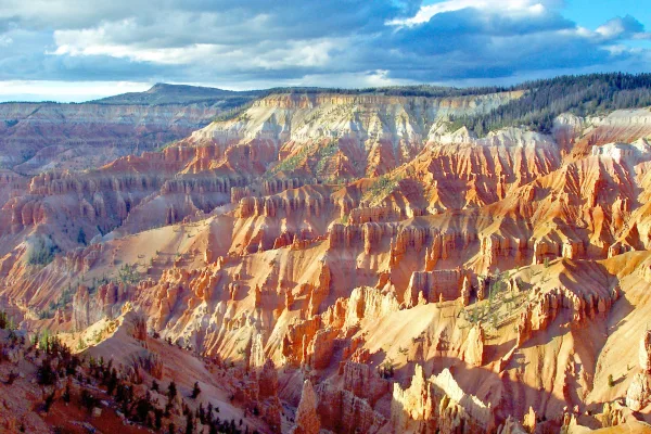
National Monument
Crowning the Grand Staircase, Cedar Breaks sits at over 10,000 feet and looks down into a half-mile deep geologic amphitheater. Come wander among timeless bristlecone pines, stand in lush meadows of w...
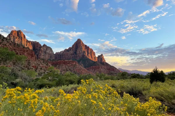
National Park
Follow the paths where people have walked for thousands of years. Gaze up at massive sandstone cliffs of cream, pink, and red that soar into a brilliant blue sky. Experience the tall, stretching walls...
Park data from the National Park Service API. Alerts update every 2 hours.
304.2 mi in 5h 18m across surface roads — expect steady turns and local traffic rather than long highway runs.
Expect a hands-on drive with frequent turns and local roads rather than long highway stretches. There are only a few real navigation decisions along the way. The trickiest moment comes around 0.1 miles in near 100 West.
Easy - simple navigation with a manageable amount of wheel time
Balances navigation complexity with total wheel time.
This is a straightforward 5h 18m drive. You will face about 12 decision points, but nothing that requires special attention if you follow navigation.
Where does it get tricky?
The main spots that need attention: at 0.1 miles (100 West): Navigation decision point; at 0.2 miles (200 South): Navigation decision point; at 256.9 miles: Exit ramp - move to the correct lane early. Lane positioning matters here.
Weekend Trip
Doable as a same-day drive at 5h 18m. Total distance: 304.2 miles.
Family Friendly
Moderate complexity with 1 natural rest stops along the way.
Solo Traveler
5h 18m drive, comfortable solo distance.
First-Time Driver
Mostly highway driving (1%). Straightforward navigation.
Scenic Drive
Mostly surface roads route profile with national parks nearby.
Compiled by the Trip.ovh planning team at COD Solutions Oy from open government datasets — OSRM over OpenStreetMap for geometry, EIA for fuel prices, and NPS for national parks. See our methodology for refresh cadence and limitations.
Was this helpful?
Thanks for your feedback!
Your tip has been submitted. Thanks!
/500
Recent Tips
·
Explore more options from Saint George, UT or browse trips ending in Park City, UT.
Looking for more statewide routes? Browse UT road trips.