Origin
South Venice, FL
Afternoon in South Venice on Saturday
Local time
3:41 PM
EDT
Current temp
66°F
Unavailable
Live forecast
Compiled and reviewed by the Trip.ovh planning team at COD Solutions Oy · Last reviewed Apr 18, 2026 · Editorial standards
Drive Time
5h 15m
Distance
267.3 mi
430 km
Drive Score
8/10
Great drive
Same Day?
Yes, doable
Fuel Cost
$43
one way
EV Charging
Unknown
Estimated drive times based on typical traffic patterns. Actual times may vary with weather, construction, and real-time conditions.

South Venice, FL
Arian Fernandez

Jacksonville, FL
Wikimedia Commons
The drive from South Venice, FL to Jacksonville, FL covers 267.3 miles and takes about 5h 15m behind the wheel. This route is realistic as a one-day drive if you keep your stops efficient.
The route leans on I 75, US 301, I 10 for much of the mileage, and the overall profile is mostly highway. The longest uninterrupted segment is about 156.1 miles on I 75. At current regular gas prices, budget about $42.55 one way before food or hotel costs.
Trip Pace
Same-day drive is realistic
A same-day return is possible, but it will make for a full day on the road.
Break Rhythm
1 planned break
Plan on a short reset every 3 to 4 hours to stay fresh behind the wheel.
Midpoint
133.7 miles from South Venice, FL
A natural place for your longest stop of the day , about 2h 32m into the drive .
| Road | Distance | Duration |
|---|---|---|
| I 75 | 156.1 mi | 2h 48m |
| US 301 | 75.9 mi | 1h 34m |
| I 10 | 16.8 mi | 19m |
| FL 681 | 4.3 mi | 5m |
| Tamiami Trail | 3.8 mi | 6m |
| US 41 By-Pass | 3 mi | 5m |
| Northwest 70th Street | 1.5 mi | 2m |
| FL 326 | 1.1 mi | 1m |
Step-by-step road directions between South Venice, FL and Jacksonville, FL.
Start on Hudson Road
Turn left onto Sterling Road
Turn right onto Jamaica Road
Continue on West Seminole Drive
Turn left onto US 41
Keep slight right at fork onto US 41
Turn straight onto US 41
Turn slight right onto FL 681
Merge onto I 75
Take the exit
Turn slight right
Turn slight right onto FL 326
Continue on FL 326
Turn left onto US 301; US 441
Turn straight onto US 301
Continue on US 301
Take the exit
Merge onto I 10
Take the exit
Keep slight left at fork
Merge onto I 95
Take the exit onto US 17; FL 228
Turn straight onto US 17; US 23; FL 228
Arrive at destination
Morning Departure
An early start around 7-8 AM gets you there with plenty of daylight left.
Evening Departure
A late afternoon start means arriving after dark. Morning is better.
This is a comfortable same-day trip.
Departure
Before you leave
Start with fuel, water, and navigation already sorted so the first hour feels easy.
First stop
Around 59 miles or 1h 12m in
Use this first pause for coffee, a restroom break, and a quick traffic check ahead.
Halfway reset
Around 133.7 miles or 2h 32m in
This is the best place for your longest stop, a real meal, and a full fuel check.
Final approach
Final hour starts around 4h 14m
Traffic, exits, and arrival timing usually matter more near Jacksonville, FL than in the middle of the route.
Open the route before leaving South Venice, FL so your first major turns are already loaded.
Leave with enough water and a charging cable within reach, not packed away.
Check your fuel range against the first long segment, especially if you are starting outside city service areas.
Day 1
Settle into the route from South Venice, FL
This is one driving day of about 267.3 miles and 5h 15m.
Rest stops, refuel points, and overnight suggestions along this route.

Mid-route town
Meal stop
134 mi into the route
Best for: Lunch, fuel, and a longer reset
This sits close to the middle of the route, so it works well for the longest stop of the day.
A short stop after about 59 miles helps settle the day before fatigue starts building.
The midpoint is around 133.7 miles from South Venice, FL, which is a good place for a longer meal and fuel stop.
Before the longest stretch
Fuel checkTop up before I 75 if your tank is already low. That segment runs about 156.1 miles.
These stop ideas are pacing suggestions — the exact town or exit can change with traffic, hotel plans, and fuel range.
5 decision points cluster between mile 0 and 266.4 — GPS handles the exact turns, but know they're coming. Your lane choice matters more than the turn itself.
Turn left onto Sterling Road
Navigation decision point
Keep slight right at fork onto US 41 / US 41 By-Pass
Highway fork - watch signs carefully. Lane positioning matters here
Take the exit toward FL 326
Exit ramp - move to the correct lane early. Lane positioning matters here
Keep slight left at fork toward I 95 North: International Airport, Savannah
Highway fork - watch signs carefully. Lane positioning matters here. Multiple destination signs - pick the right one
Take the exit onto US 17; FL 228 toward Union Street, Beaver Street
Exit ramp - move to the correct lane early. Multiple destination signs - pick the right one
Regular Gas
$42.55 one way
$85.09 round trip
| Fuel Type | $/gal | One Way | Round Trip |
|---|---|---|---|
| midgrade | $4.40 | $46.28 | $92.57 |
| premium | $4.72 | $49.70 | $99.41 |
| diesel | $5.61 | $59.02 | $118.03 |
No toll roads detected on this route.
Estimated Trip Cost (one way, 1 person)
Fuel
$43
Meals
$25–$50
Total
$68–$93
Rough estimate based on US averages. Hotel $80–$140/night, meals $25–$50/day.
Estimated CO2 emission: 93.5 kg one way. Prices: EIA weekly data, 2026-04-13.
Driving Electric?
About $28 in charging · 0 stops · 67% less CO2
| Vehicle Type | kWh | Stops | DC Fast | Home Charge |
|---|---|---|---|---|
| Average EV | 80.2 | 0 | $28.07 | $12.83 |
| Efficient EV | 66.8 | 0 | $23.39 | $10.69 |
| EV Truck/SUV | 106.9 | 1 | $37.42 | $17.11 |
Gas CO2
94 kg
EV CO2
31 kg (67% less)
Plan for 0 charging stops, roughly every 270 miles. Allow 25-40 minutes per stop at a DC fast charger.
DC fast charging avg $0.35/kWh. Home charging avg $0.16/kWh. US grid CO2: 0.39 kg/kWh.
Current conditions at both ends of the drive.
Origin
Afternoon in South Venice on Saturday
Local time
3:41 PM
EDT
Current temp
66°F
Unavailable
Destination
Afternoon in Jacksonville on Saturday
Local time
3:41 PM
EDT
Current temp
60°F
Unavailable
Seasonal Notes
Summer travel usually means heavier construction, hotter rest stops, and busier weekend traffic around major cities.
Winter travel shortens daylight, so a route that looks manageable on paper can feel much longer after dark.
Holiday weekends tend to make both departure and arrival windows slower than the raw route time suggests.
Time zone
Origin and destination are on the same clock, so arrival timing is easier to judge at a glance.
Temperature spread
A meaningful temperature swing is a good cue to rethink layers, water, and how soon you want to arrive.
Road read
An early start around 7-8 AM gets you there with plenty of daylight left.
Weather data from the National Weather Service. Conditions may change; check closer to your travel date.
Worth a detour if your schedule allows.
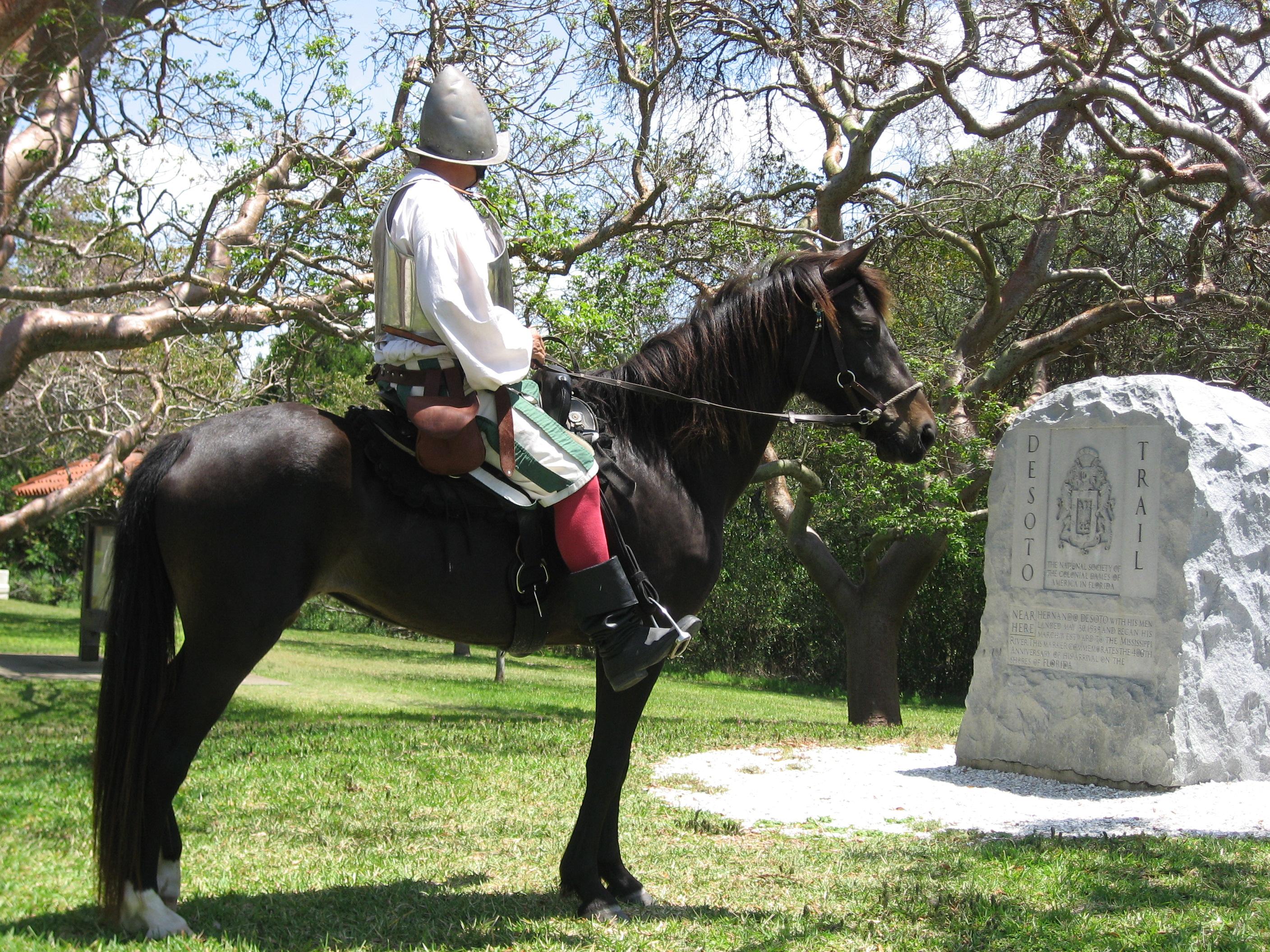
National Memorial
In May 1539, Conquistador Hernando de Soto’s army of soldiers, hired mercenaries, craftsmen, and clergy made landfall in Tampa Bay. They were met with fierce resistance of indigenous people protecting...
Park data from the National Park Service API. Alerts update every 2 hours.
267.3 mi in 5h 15m, mostly highway — 156.1 mi of that is on I 75.
This is a straightforward highway drive that stays mostly on I 75 and US 301. This route has several spots where lane changes, forks, or exits need your full attention. The trickiest moment comes early in the drive near Sterling Road.
Demanding - plan breaks and stay ahead of the key maneuvers
Balances navigation complexity with total wheel time.
This is a demanding drive. With 16 significant decision points across 267.3 miles, you will need to stay alert - especially through interchange areas and urban stretches. Consider splitting it into segments if you are not comfortable with fast highway navigation.
Where does it get tricky?
The main spots that need attention: near the start (Sterling Road): Navigation decision point; at 1.9 miles (US 41 / US 41 By-Pass): Highway fork - watch signs carefully. Lane positioning matters here; at 168.1 miles: Exit ramp - move to the correct lane early. Lane positioning matters here.
Jacksonville occupies one of the most coveted spots on the Atlantic coast. Set amongst abundant beaches and possessing an ideal subtropical climate, its crown jewel is the unique habitat and natural beauty of the St. Johns River. For this reason and more, "The River City" is a popular destination for vacationers looking for a laid-back Sunshine State escape.
City content from Wikivoyage (CC BY-SA 4.0) and Wikidata (CC0).
Weekend Trip
Doable as a same-day drive at 5h 15m. Total distance: 267.3 miles.
Family Friendly
Moderate complexity with 1 natural rest stops along the way.
Solo Traveler
5h 15m drive, comfortable solo distance.
First-Time Driver
Mostly highway driving (97%). Some complex stretches to watch for.
Compiled by the Trip.ovh planning team at COD Solutions Oy from open government datasets — OSRM over OpenStreetMap for geometry, EIA for fuel prices, and NPS for national parks. See our methodology for refresh cadence and limitations.
Was this helpful?
Thanks for your feedback!
Your tip has been submitted. Thanks!
/500
Recent Tips
·
Explore more options from South Venice, FL or browse trips ending in Jacksonville, FL.
Looking for more statewide routes? Browse FL road trips.