Trip from Suttons Bay, MI to Lansing, MI

Drive Time

4h 1m

Distance

198.2 mi

319 km

Drive Score

9/10

Great drive

Same Day?

Yes, doable

Fuel Cost

$30

one way

EV Charging

Excellent

36 DC fast

Best Time to Leave

Save up to 39 min
4 AM
3h 48m ★
6 AM
4h 1m
8 AM
4h 27m
10 AM
4h 11m
12 PM
4h 8m
3 PM
4h 12m
5 PM
4h 26m
8 PM
3h 54m

Estimated drive times based on typical traffic patterns. Actual times may vary with weather, construction, and real-time conditions.

Trip Overview

The drive from Suttons Bay, MI to Lansing, MI covers 198.2 miles and takes about 4h 1m behind the wheel. This route is realistic as a one-day drive if you keep your stops efficient.

The route leans on US 10, East M-115 Highway, US-127 for much of the mileage, and the overall profile is mixed drive. The longest uninterrupted segment is about 54.7 miles on US 10. At current regular gas prices, budget about $30.10 one way before food or hotel costs.

Trip Pace

Same-day drive is realistic

A same-day return is possible, but it will make for a full day on the road.

Break Rhythm

1 planned break

Plan on a short reset every 3 to 4 hours to stay fresh behind the wheel.

Midpoint

99.1 miles from Suttons Bay, MI

A natural place for your longest stop of the day , about 2h 16m into the drive .

Drive Character

The drive from Suttons Bay, MI to Lansing, MI covers 198.2 miles and takes about 4h 1m, using a mix of highways and local roads.

Expect a mix of faster highway mileage and slower local approaches near the beginning or end.
There are about 32 navigation steps in the underlying route data, so the final approach matters more than the middle miles.
US 10 is the longest continuous segment at about 54.7 miles.

How Hard Is This Drive?

This route mixes highway mileage with some local-road sections near the start or finish. You will hit about 20 points where you need to pay attention to lane position or signs. The trickiest moment comes around 16.6 miles in near East Eighth Street.

Route Complexity 5/10

Moderate - straightforward overall, but long enough or busy enough to require pacing

This drive requires moderate attention. Across 198.2 miles you will encounter 20 spots where lane choice or exit timing matters. Not difficult for experienced highway drivers, but worth previewing the tricky sections before you go.

Where does it get tricky?

The main spots that need attention: at 16.6 miles (East Eighth Street): Lane positioning matters here; at 33.4 miles (M 113 / East M 113): Navigation decision point; at 65.9 miles (M 55): Exit ramp - move to the correct lane early. Multiple destination signs - pick the right one.

Critical Maneuvers

5 of 20 key points

These are the spots where you need to pay the most attention. Preview them before you drive.

6
16.6 mi into trip | ~25m in | East Eighth Street

Turn left onto East Eighth Street

Lane positioning matters here

Use the straight lane.
5
33.4 mi into trip | ~52m in | M 113 / East M 113

At end of road, turn left onto M 113 / East M 113

Navigation decision point

5
65.9 mi into trip | ~1h 30m in | M 55

Take the exit onto M 55 toward M 115, M 55 West: Frankfort, Clare

Exit ramp - move to the correct lane early. Multiple destination signs - pick the right one

Toward M 115, M 55 West: Frankfort, Clare
7
194.9 mi into trip | ~3h 55m in

Take the exit toward I 496 West: Downtown Lansing

Exit ramp - move to the correct lane early. Lane positioning matters here

Use the slight right lane. Exit 77 Toward I 496 West: Downtown Lansing
5
197.4 mi into trip | ~3h 59m in

Take the exit toward Downtown

Exit ramp - move to the correct lane early

Exit 6 Toward Downtown

Towns Along This Route

Between Suttons Bay, MI and Lansing, MI, road signs point toward M 115, M 55 West: Frankfort and Clare.

M 115

65.9 mi in | ~1h 30m | via M 55

M 55 West: Frankfort

65.9 mi in | ~1h 30m | via M 55

Clare

65.9 mi in | ~1h 30m | via M 55

Main Roads

Road Distance Duration
US 10 54.7 mi 54m
East M-115 Highway 34.9 mi 47m
US-127 29.8 mi 31m
North US 131 Highway 22.9 mi 24m
South West Bay Shore Drive 14.8 mi 21m
South Bagley Road 8.9 mi 10m
East M 113 8.7 mi 11m
South Garfield Road 6.7 mi 9m
Longest stretch: US 10 — 54.7 mi, about 54m

Turn-by-Turn Driving Directions

Step-by-step road directions between Suttons Bay, MI and Lansing, MI.

1

Start on North Front Street

339 ft · 15 sec · North Front Street
2

Turn right onto East Madison Street

166 ft · 12 sec · East Madison Street
3

Turn left onto M 22

442 ft · 14 sec · North Saint Josephs Avenue
4

Continue on M 22

15 mi · 21 min · South West Bay Shore Drive
5

Turn slight left onto M 22

95 ft · 6 sec · South West Bay Shore Drive
6

Turn left onto M 22; M 72

1.2 mi · 2 min · West Grandview Parkway
7

Turn right onto North Union Street

0.4 mi · 58 sec · North Union Street
8

Turn left onto East Eighth Street

1.4 mi · 2 min · East Eighth Street
Use the straight lane.
9

Turn right onto CR 611

1.8 mi · 3 min · South Garfield Avenue
10

Continue on CR 611

3.5 mi · 5 min · North Garfield Road
11

Enter roundabout onto CR 611

72 ft · 4 sec · South Garfield Road
12

Continue on CR 611

6.7 mi · 9 min · South Garfield Road
13

Turn left onto Voice Road

2.0 mi · 3 min · Voice Road
14

Continue on Clark Road

1.5 mi · 2 min · Clark Road
15

At end of road, turn left onto M 113

8.7 mi · 11 min · East M 113
16

Merge onto US 131

1.0 mi · 1 min · US 131
17

Continue on US 131

23 mi · 24 min · North US 131 Highway
18

Take the exit onto M 55

0.4 mi · 1 min · M 55
Toward M 115, M 55 West: Frankfort, Clare
19

Turn left onto M 115; M 55

35 mi · 47 min · East M-115 Highway
20

Take the exit

0.3 mi · 50 sec
Toward US 10 East: Clare
21

Merge onto US 10

55 mi · 54 min · US 10
22

Continue on US 127

5.9 mi · 6 min · South Bagley Road
23

Continue on US 127

1.4 mi · 1 min · US-127
24

Continue on US 127

3.0 mi · 3 min · South Bagley Road
25

Continue on US 127

28 mi · 29 min · US-127
26

Take the exit

0.6 mi · 1 min
Exit 77 Toward I 496 West: Downtown Lansing Use the slight right lane.
27

Merge onto I 496

1.9 mi · 1 min · Ransom E Olds Freeway
28

Take the exit

0.3 mi · 38 sec
Exit 6 Toward Downtown
29

Turn right onto South Walnut Street

0.4 mi · 1 min · South Walnut Street
30

Turn right onto West Allegan Street

412 ft · 12 sec · West Allegan Street
31

Turn right onto Townsend Street

22 ft · 1 sec · Townsend Street
32

Arrive at destination

Townsend Street

Trip Plan

Morning Departure

An early start around 7-8 AM gets you there with plenty of daylight left.

Evening Departure

A late afternoon start means arriving after dark. Morning is better.

You can normally do this drive in one day.
Plan roughly 1 meaningful break for fuel, food, and rest.
The halfway point lands around 99.1 miles from Suttons Bay, MI, or about 2h 16m into the drive.
The longest continuous stretch on this route runs about 54.7 miles.

This is a comfortable same-day trip.

Departure

Before you leave

Start with fuel, water, and navigation already sorted so the first hour feels easy.

First stop

Around 80 miles or 1h 49m in

Use this first pause for coffee, a restroom break, and a quick traffic check ahead.

Halfway reset

Around 99.1 miles or 2h 16m in

This is the best place for your longest stop, a real meal, and a full fuel check.

Final approach

Final hour starts around 3h 21m

Traffic, exits, and arrival timing usually matter more near Lansing, MI than in the middle of the route.

Before You Leave

+

Open the route before leaving Suttons Bay, MI so your first major turns are already loaded.

+

Leave with enough water and a charging cable within reach, not packed away.

+

Check your fuel range against the first long segment, especially if you are starting outside city service areas.

Day 1

Settle into the route from Suttons Bay, MI

This is one driving day of about 198.2 miles and 4h 1m.

Your first comfortable stop window is around 80 miles from Suttons Bay, MI.
This route can stay practical as a one-day drive if traffic stays reasonable.
Plan about 1 real break rather than only quick fuel stops.
The longest stretch is on US 10 for about 54.7 miles.

Where to Stop

Rest stops, refuel points, and overnight suggestions along this route.

Halfway Point

Midpoint

About 99.1 mi from Suttons Bay, MI · 2h 16m into the drive

Mid-route town

Meal stop

Waukegan, IL

99 mi into the route

Best for: Lunch, fuel, and a longer reset

This sits close to the middle of the route, so it works well for the longest stop of the day.

Pacing Suggestions

Waukegan, IL

Fuel and coffee

A short stop after about 80 miles helps settle the day before fatigue starts building.

Waukegan, IL

Meal break

The midpoint is around 99.1 miles from Suttons Bay, MI, which is a good place for a longer meal and fuel stop.

Arriving in Lansing, MI

The final approach into Lansing, MI usually feels slower than the middle of the drive, so avoid planning your tightest schedule at the very end.

Try to arrive with enough fuel left to skip an immediate station stop unless you already know the area around Lansing, MI.

These stop ideas are pacing suggestions — the exact town or exit can change with traffic, hotel plans, and fuel range.

National Parks Near This Route

Worth a detour if your schedule allows.

Sleeping Bear Dunes National Lakeshore

Sleeping Bear Dunes National Lakeshore

National Lakeshore

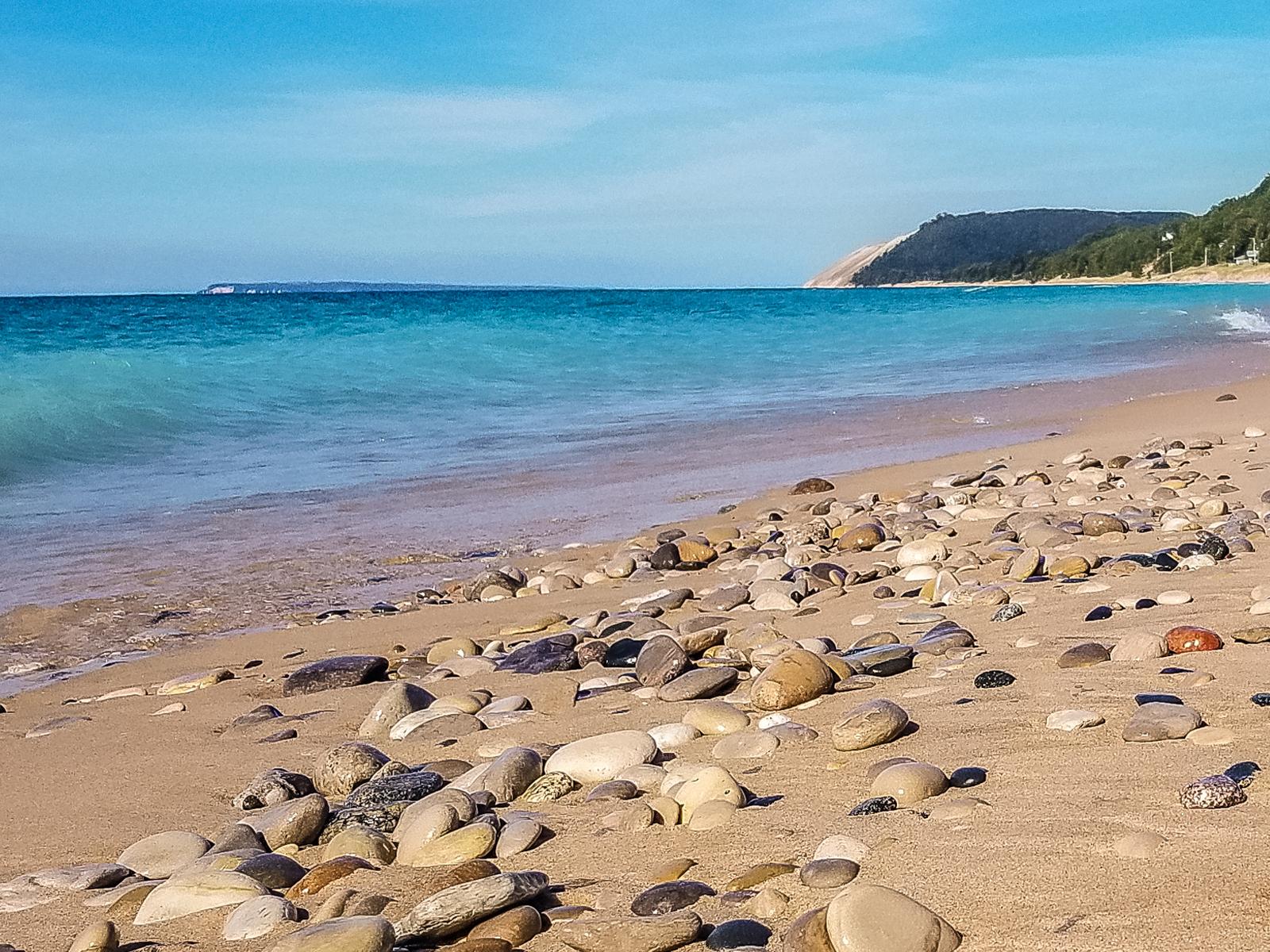
Miles of sand beach, bluffs that tower 450’ above Lake Michigan, lush forests, clear inland lakes, unique flora and fauna make up the natural world of Sleeping Bear Dunes. High dunes afford spectacula...

19 mi from route ~47 min detour $25
View on nps.gov

Park data from the National Park Service API. Alerts update every 2 hours.

Fuel & Cost

Regular Gas

$30.10 one way

$60.21 round trip

$3.86/gal 25.4 MPG avg 69 kg CO2
Fuel Type $/gal One Way Round Trip
midgrade $4.25 $33.19 $66.37
premium $4.80 $37.42 $74.83
diesel $5.64 $44.03 $88.07

No toll roads detected on this route.

Estimated Trip Cost (one way, 1 person)

Fuel

$30

Meals

$25–$50

Total

$55–$80

Rough estimate based on US averages. Hotel $80–$140/night, meals $25–$50/day.

Estimated CO2 emission: 69.3 kg one way. Prices: EIA weekly data, 2026-04-06.

EV Charging Along Route

36 DC fast chargers · Coverage: excellent

Meijer - Tesla Supercharger

Traverse City, MI

Tesla

10 DCFC

The Heights at Eastwood - Tesla Supercharger

Lansing, MI

Tesla

10 DCFC

Fox Ford Traverse City - DCFC

Traverse City, MI

Blink Network

8 DCFC

Meijer - Tesla Supercharger

Cadillac, MI

Tesla

8 DCFC

Doherty Hotel - Tesla Supercharger

Clare, MI

Tesla

8 DCFC

Traverse City, MI

Traverse City, MI

RIVIAN_ADVENTURE

6 DCFC

Clare, MI

Clare, MI

RIVIAN_ADVENTURE

6 DCFC

Clinch Park Marina Public Parking

Traverse City, MI

RED_E

4 DCFC

ChargePoint Network: 13 RED_E: 9 Tesla: 4 Blink Network: 3 RIVIAN_ADVENTURE: 2 FORD_CHARGE: 2 Non-Networked: 1 Electrify America: 1 EV Connect: 1

Station data from NREL Alternative Fuel Stations database.

Driving Electric?

About $21 in charging · 0 stops · 67% less CO2

Vehicle Type kWh Stops DC Fast Home Charge
Average EV 59.5 0 $20.81 $9.51
Efficient EV 49.6 0 $17.34 $7.93
EV Truck/SUV 79.3 0 $27.75 $12.68

Gas CO2

69 kg

EV CO2

23 kg (67% less)

This trip is well within single-charge range for most EVs. No charging stops needed if you start fully charged.

DC fast charging avg $0.35/kWh. Home charging avg $0.16/kWh. US grid CO2: 0.39 kg/kWh.

Travel Intel

Current conditions at both ends of the drive.

Forecast data refreshed 3 days ago

Origin

Suttons Bay, MI

Morning in Suttons Bay on Monday

Local time

8:20 AM

EDT

Current temp

56°F

Unavailable

Live forecast

Destination

Lansing, MI

Morning in Lansing on Monday

Local time

8:20 AM

EDT

Current temp

46°F

Unavailable

Live forecast

Seasonal Notes

Summer travel usually means heavier construction, hotter rest stops, and busier weekend traffic around major cities.

Winter travel shortens daylight, so a route that looks manageable on paper can feel much longer after dark.

Holiday weekends tend to make both departure and arrival windows slower than the raw route time suggests.

Time zone

Same local time

Origin and destination are on the same clock, so arrival timing is easier to judge at a glance.

Temperature spread

10 degrees cooler at arrival

A meaningful temperature swing is a good cue to rethink layers, water, and how soon you want to arrive.

Road read

4h 1m on the road

An early start around 7-8 AM gets you there with plenty of daylight left.

Weather data from the National Weather Service. Conditions may change; check closer to your travel date.

Frequently Asked Questions

The drive from Suttons Bay, MI to Lansing, MI covers 198.2 miles and takes about 4h 1m without stops. Add 15-30 minutes for a fuel or rest stop on longer drives.
The main roads are US 10, East M-115 Highway, US-127. Expect a mix of highway and local road driving.
This is a comfortable same-day trip.
The midpoint is about 99.1 miles from Suttons Bay, MI. Look for rest areas, gas stations, or food options near the halfway mark.
At current regular gas prices, expect to spend about $30.10 one way. This estimate uses 25.4 MPG — your actual cost will vary with your vehicle's fuel efficiency and current gas prices.
An early start around 7-8 AM gets you there with plenty of daylight left. A late afternoon start means arriving after dark. Morning is better.
Plan about 1 meaningful break for fuel, food, or rest. Plan on a short reset every 3 to 4 hours to stay fresh behind the wheel.
This drive requires moderate attention. Across 198.2 miles you will encounter 20 spots where lane choice or exit timing matters. Not difficult for experienced highway drivers, but worth previewing the tricky sections before you go.
The main spots that need attention: at 16.6 miles (East Eighth Street): Lane positioning matters here; at 33.4 miles (M 113 / East M 113): Navigation decision point; at 65.9 miles (M 55): Exit ramp - move to the correct lane early. Multiple destination signs - pick the right one.
Between Suttons Bay, MI and Lansing, MI, road signs point toward M 115, M 55 West: Frankfort and Clare.

Was this route helpful?

Thanks for your feedback!

Your tip has been submitted. Thanks!

/500

Explore More

Explore more options from Suttons Bay, MI or browse trips ending in Lansing, MI.

Looking for more statewide routes? Browse MI road trips.

Explore maps for Suttons Bay, MI or Lansing, MI on MapSof.net.