This short 13.8-mile drive from West Caldwell to Newark, NJ, is designed as a quick, single-day trip, taking approximately 20 minutes to complete. Primarily utilizing highways, you'll find this route is highly efficient for getting you to your destination. With a modest fuel cost of around $2, it's an economical option for local travel within the Northeast region. The Essex Freeway and Passaic Avenue are key arteries on this journey, making it a straightforward point-to-point experience. Given its brevity, no overnight stays are necessary, allowing for maximum flexibility in your schedule.
Trip Pace
Same-day drive is realistic
A same-day return is realistic if you keep stops short.
Break Rhythm
0 planned breaks
A short stop every 2 to 3 hours is enough for this drive.
Midpoint
6.9 miles from West Caldwell, NJ
A natural place for your longest stop of the day
, about 10m into the drive
.
Loading map...
Drive Character
Expect a drive that's predominantly highway-focused, with 74% of the route utilizing faster roadways. The longest uninterrupted stretch you'll encounter is 9.9 miles along the Essex Freeway, offering a consistent pace for a significant portion of your journey. While much of the drive is on main roads like Essex Freeway and University Avenue, the character leans towards efficient travel rather than scenic detours. This route prioritizes directness, making it a functional choice for straightforward transit.
Most of the miles stay on highways, which makes pacing and fuel planning easier than turn-by-turn city driving.
There are about 12 navigation steps in the underlying route data, so the final approach matters more than the middle miles.
Essex Freeway is the longest continuous segment at about 9.9 miles.
How Hard Is This Drive?
This is a straightforward highway drive that stays mostly on Essex Freeway and Passaic Avenue. You will hit about 10 points where you need to pay attention to lane position or signs. The trickiest moment comes around 1.9 miles in near CR 611 / Eagle Rock Avenue.
Route Complexity6/10
Moderate - straightforward overall, but long enough or busy enough to require pacing
This drive requires moderate attention. Across 13.8 miles you will encounter 10 spots where lane choice or exit timing matters. Not difficult for experienced highway drivers, but worth previewing the tricky sections before you go.
Where does it get tricky?
The main spots that need attention: at 1.9 miles (CR 611 / Eagle Rock Avenue): Navigation decision point; at 2.1 miles (CR 609 / Eisenhower Parkway): Navigation decision point; at 12.5 miles: Exit ramp - move to the correct lane early. Lane positioning matters here. Multiple destination signs - pick the right one.
Critical Maneuvers
5 of 10 key points
These are the spots where you need to pay the most attention. Preview them before you drive.
5
1.9 mi into trip|~3m in|CR 611 / Eagle Rock Avenue
At end of road, turn right onto CR 611 / Eagle Rock Avenue
Navigation decision point
5
2.1 mi into trip|~3m in|CR 609 / Eisenhower Parkway
Turn right onto CR 609 / Eisenhower Parkway
Navigation decision point
8
12.5 mi into trip|~17m in
Take the exit toward Martin Luther King Boulevard, Broad Street Station, Rutgers University, Essex County College
Exit ramp - move to the correct lane early. Lane positioning matters here. Multiple destination signs - pick the right one
Use the slight right lane.
Exit 14
Toward Martin Luther King Boulevard, Broad Stre...
6
12.7 mi into trip|~17m in|Dr. Martin Luther King Jr. Boulevard
Turn right onto Dr. Martin Luther King Jr. Boulevard
Lane positioning matters here
Use the right lane.
6
13.6 mi into trip|~19m in|CR 510 / Market Street
Turn left onto CR 510 / Market Street
Lane positioning matters here
Use the straight / left lanes.
Towns Mentioned on Route Signs
Based on OSRM destination-sign hints, not a full list of every settlement the road passes.
Between West Caldwell, NJ and Newark, NJ, road signs point toward Broad Street Station, Rutgers University and Essex County College.
Broad Street Station
12.5 mi in|~17m
Rutgers University
12.5 mi in|~17m
Essex County College
12.5 mi in|~17m
Main Roads
Road
Distance
Duration
Essex Freeway
9.9 mi
13m
Passaic Avenue
1.9 mi
3m
University Avenue
0.7 mi
1m
Eagle Rock Avenue
0.2 mi
<1m
Eisenhower Parkway
0.2 mi
<1m
Market Street
0.2 mi
<1m
Orange Street
0.1 mi
<1m
Dr. Martin Luther King Jr. Boulevard
<0.1 mi
<1m
Longest stretch:
Essex Freeway
— 9.9 mi, about 13m
Turn-by-Turn Driving Directions
Step-by-step road directions between West Caldwell, NJ and Newark, NJ.
1
Start on CR 613
1.9 mi·3 min·Passaic Avenue
2
At end of road, turn right onto CR 611
0.2 mi·27 sec·Eagle Rock Avenue
3
Turn right onto CR 609
0.2 mi·21 sec·Eisenhower Parkway
4
Take the ramp
0.2 mi·33 sec
Toward I 280 East
5
Merge onto I 280
9.9 mi·13 min·Essex Freeway
Use the straight / slight right lanes.
6
Take the exit
0.1 mi·21 sec
Exit 14Toward Martin Luther King Boulevard, Broad Street Station, Rutgers University, Essex County CollegeUse the slight right lane.
7
Turn right onto Dr. Martin Luther King Jr. Boulevard
269 ft·9 sec·Dr. Martin Luther King Jr. Boulevard
Use the right lane.
8
Keep slight left at fork onto Dr. Martin Luther King Jr. Boulevard
140 ft·11 sec·Dr. Martin Luther King Jr. Boulevard
9
Turn left onto Orange Street
0.1 mi·16 sec·Orange Street
10
Turn right onto University Avenue
0.7 mi·1 min·University Avenue
11
Turn left onto CR 510
0.2 mi·38 sec·Market Street
Use the straight / left lanes.
12
Arrive at destination
CR 510
Trip Plan
For this quick 20-minute trip, timing your departure can help you avoid local traffic, especially since the total duration is so short. You won't need to worry about splitting this drive, and with only 13.8 miles, stops are optional and can be made as needed. Keep an eye on your fuel gauge, though the estimated cost is only $2, ensuring you have enough for the journey. A specific tip for this route: be aware that the transition from the Essex Freeway onto local roads like Passaic Avenue can sometimes have moderate traffic, so allow a few extra minutes if you're on a tight schedule.
Morning Departure
Leave by 9 AM and you'll arrive before lunch.
Evening Departure
Even a 4 PM departure gets you there before dark in summer.
You can normally do this drive in one day.
You may only need one short stretch break if traffic stays light.
The halfway point lands around 6.9 miles from West Caldwell, NJ, or about 10m into the drive.
The longest continuous stretch on this route runs about 9.9 miles.
This is a comfortable same-day trip.
Departure
Before you leave
Start with fuel, water, and navigation already sorted so the first hour feels easy.
First stop
Around 13.8 miles or 20m in
Use this first pause for coffee, a restroom break, and a quick traffic check ahead.
Halfway reset
Around 6.9 miles or 10m in
This is the best place for your longest stop, a real meal, and a full fuel check.
Final approach
Final hour starts around 16m
Traffic, exits, and arrival timing usually matter more near Newark, NJ than in the middle of the route.
Before You Leave
+
Open the route before leaving West Caldwell, NJ so your first major turns are already loaded.
+
Leave with enough water and a charging cable within reach, not packed away.
+
Check your fuel range against the first long segment, especially if you are starting outside city service areas.
Day 1
Settle into the route from West Caldwell, NJ
This is one driving day of about 13.8 miles and 20m.
Your first comfortable stop window is around 80 miles from West Caldwell, NJ.
This route can stay practical as a one-day drive if traffic stays reasonable.
You may only need one short stretch stop if conditions stay smooth.
The longest stretch is on Essex Freeway for about 9.9 miles.
Where to Stop
Rest stops, refuel points, and overnight suggestions along this route.
Halfway Point
Midpoint
About 6.9 mi from West Caldwell, NJ
· 10m into the drive
The midpoint is around 6.9 miles from West Caldwell, NJ, which is a good place for a longer meal and fuel stop.
Arriving in Newark, NJ
The final approach into Newark, NJ usually feels slower than the middle of the drive, so avoid planning your tightest schedule at the very end.
Try to arrive with enough fuel left to skip an immediate station stop unless you already know the area around Newark, NJ.
These stop ideas are pacing suggestions — the exact town or exit can change with traffic, hotel plans, and fuel range.
National Parks Near This Route
Worth a detour if your schedule allows.
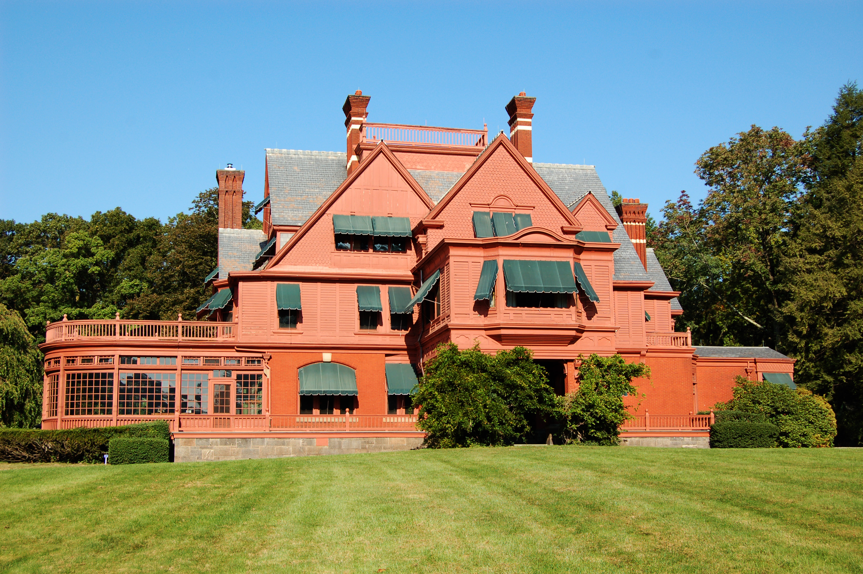
Thomas Edison National Historical Park
National Historical Park
Today, the brick buildings on Main Street in West Orange, NJ seem quiet, betraying little evidence of the research, development, and innovation of their heyday. Visitors can step back in time to Thoma...
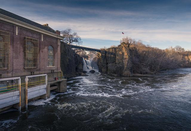
Silk cloth and steam locomotives; textiles and continuous paper rolls; firearms and aircraft engines. What do these things have in common? All were manufactured in the same place - Paterson, NJ. In 17...
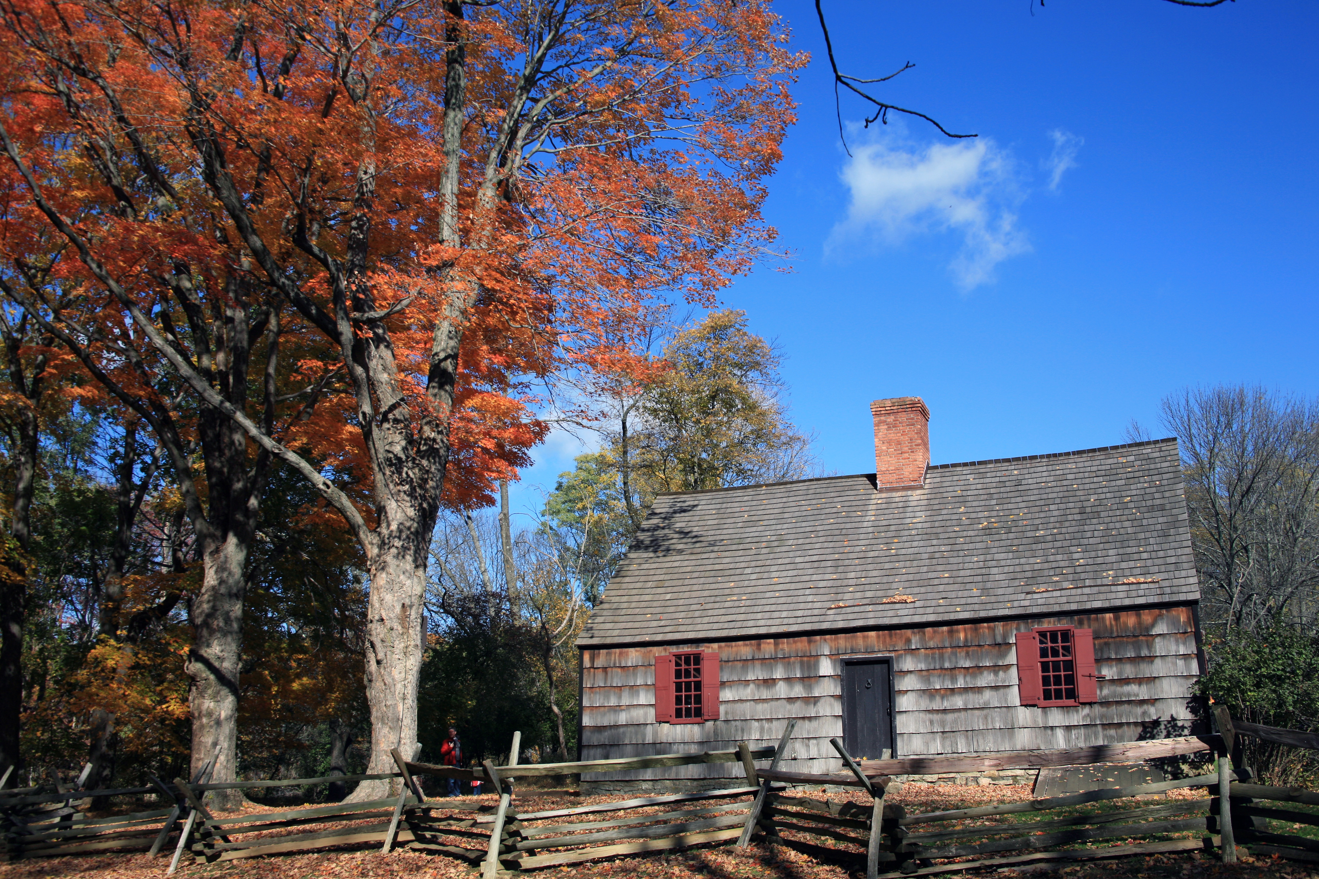
Morristown National Historical Park commemorates the sites of General Washington and the Continental Army’s winter encampment from December 1779 to June 1780, where soldiers survived the coldest winte...
12 mi from route
~29 min detour
Free
near mile 1.9
Spanning 27,000 acres from Sandy Hook in New Jersey to Breezy Point in New York City, the park is both the gateway from the ocean into New York Harbor, and the gateway to the National Park Service for...
18 mi from route
~45 min detour
Free
near mile 13.8
Station data from NREL Alternative Fuel Stations database.
Driving Electric?
About $1 in charging
· 0 stops
· 60% less CO2
Vehicle Type
kWh
Stops
DC Fast
Home Charge
Average EV
4.1
0
$1.45
$0.66
Efficient EV
3.5
0
$1.21
$0.55
EV Truck/SUV
5.5
0
$1.93
$0.88
Gas CO2
5 kg
EV CO2
2 kg (60% less)
This trip is well within single-charge range for most EVs. No charging stops needed if you start fully charged.
DC fast charging avg $0.35/kWh. Home charging avg $0.16/kWh. US grid CO2: 0.39 kg/kWh.
Travel Intel
Current conditions at both ends of the drive.
Forecast data refreshed 4 days ago
Origin
West Caldwell, NJ
Evening
in West Caldwell on Tuesday
Local time
6:40 PM
EDT
Current temp
58°F
Unavailable
Live forecast
Destination
Newark, NJ
Evening
in Newark on Tuesday
Local time
6:40 PM
EDT
Current temp
61°F
Unavailable
Live forecast
Seasonal Notes
Summer travel usually means heavier construction, hotter rest stops, and busier weekend traffic around major cities.
Winter travel shortens daylight, so a route that looks manageable on paper can feel much longer after dark.
Holiday weekends tend to make both departure and arrival windows slower than the raw route time suggests.
Time zone
Same local time
Origin and destination are on the same clock, so arrival timing is easier to judge at a glance.
Temperature spread
3 degrees warmer at arrival
A meaningful temperature swing is a good cue to rethink layers, water, and how soon you want to arrive.
Road read
20m on the road
Use the two city cards together: check the sky where you start, then compare it with the local time and temperature at arrival.
Weather data from the National Weather Service. Conditions may change; check closer to your travel date.
Frequently Asked Questions
The drive from West Caldwell, NJ to Newark, NJ covers 13.8 miles and takes about 20m without stops. Add 15-30 minutes for a fuel or rest stop on longer drives.
The main roads are Essex Freeway, Passaic Avenue, University Avenue. Most of the drive stays on highways, so watch for ramps and exits.
This is a comfortable same-day trip.
The midpoint is about 6.9 miles from West Caldwell, NJ. Look for rest areas, gas stations, or food options near the halfway mark.
At current regular gas prices, expect to spend about $2.29 one way. This estimate uses 25.4 MPG — your actual cost will vary with your vehicle's fuel efficiency and current gas prices.
Leave by 9 AM and you'll arrive before lunch. Even a 4 PM departure gets you there before dark in summer.
This drive requires moderate attention. Across 13.8 miles you will encounter 10 spots where lane choice or exit timing matters. Not difficult for experienced highway drivers, but worth previewing the tricky sections before you go.
The main spots that need attention: at 1.9 miles (CR 611 / Eagle Rock Avenue): Navigation decision point; at 2.1 miles (CR 609 / Eisenhower Parkway): Navigation decision point; at 12.5 miles: Exit ramp - move to the correct lane early. Lane positioning matters here. Multiple destination signs - pick the right one.
Between West Caldwell, NJ and Newark, NJ, road signs point toward Broad Street Station, Rutgers University and Essex County College.