Trip from Yakima, WA to Hoquiam, WA

Drive Time

4h 32m

Distance

208.2 mi

335 km

Drive Score

8/10

Great drive

Same Day?

Yes, doable

Fuel Cost

$44

one way

EV Charging

Loading...

station data

Best Time to Leave

Save up to 40 min
4 AM
4h 19m ★
6 AM
4h 32m
8 AM
4h 59m
10 AM
4h 42m
12 PM
4h 39m
3 PM
4h 43m
5 PM
4h 58m
8 PM
4h 24m

Estimated drive times based on typical traffic patterns. Actual times may vary with weather, construction, and real-time conditions.

Downtown Hoquiam, WA, WA

Hoquiam, WA

Jack Davis

Trip Overview

The drive from Yakima, WA to Hoquiam, WA covers 208.2 miles and takes about 4h 32m behind the wheel. This route is realistic as a one-day drive if you keep your stops efficient.

The route leans on US 12, US Highway 12, Sumner Avenue for much of the mileage, and the overall profile is highway-focused drive. The longest uninterrupted segment is about 184.3 miles on US 12. At current regular gas prices, budget about $43.70 one way before food or hotel costs.

Trip Pace

Same-day drive is realistic

A same-day return is possible, but it will make for a full day on the road.

Break Rhythm

1 planned break

Plan on a short reset every 3 to 4 hours to stay fresh behind the wheel.

Midpoint

104.1 miles from Yakima, WA

A natural place for your longest stop of the day , about 2h 9m into the drive .

Drive Character

This is a 4h 32m highway drive covering 208.2 miles, with most of the trip on US 12 and US Highway 12. The longest continuous stretch is about 184.3 miles on US 12.

Most of the miles stay on highways, which makes pacing and fuel planning easier than turn-by-turn city driving.
There are about 27 navigation steps in the underlying route data, so the final approach matters more than the middle miles.
US 12 is the longest continuous segment at about 184.3 miles.

How Hard Is This Drive?

This is a straightforward highway drive that stays mostly on US 12 and US Highway 12. There are only a few real navigation decisions along the way. The trickiest moment comes around 1.7 miles in.

Route Complexity 3/10

Easy - simple navigation with a manageable amount of wheel time

This is a straightforward 4h 32m drive. You will face about 15 decision points, but nothing that requires special attention if you follow navigation.

Where does it get tricky?

The main spots that need attention: at 1.7 miles: Highway fork - watch signs carefully; at 157.8 miles (US 12): Lane positioning matters here; at 204.2 miles (East Market Street): Roundabout - know your exit number before entering.

Critical Maneuvers

5 of 15 key points

These are the spots where you need to pay the most attention. Preview them before you drive.

5
1.7 mi into trip | ~3m in

Keep slight right at fork

Highway fork - watch signs carefully

6
157.8 mi into trip | ~3h 13m in | US 12

Turn left onto US 12

Lane positioning matters here

Use the straight lane.
6
204.2 mi into trip | ~4h 21m in | East Market Street

Enter roundabout onto East Market Street

Roundabout - know your exit number before entering

7
208 mi into trip | ~4h 31m in | WA 109 / Emerson Avenue

Turn left onto WA 109 / Emerson Avenue toward Ocean Shores, Taholah

Multiple destination signs - pick the right one

Toward Ocean Shores, Taholah
6
208.2 mi into trip | ~4h 32m in | WA 109 / Simpson Avenue

Turn sharp left onto WA 109 / Simpson Avenue

Sharp turn - reduce speed on approach

Towns Along This Route

Between Yakima, WA and Hoquiam, WA, road signs point toward Tenino, Montesano and Aberdeen.

Tenino

157.5 mi in | ~3h 12m

Montesano

183.2 mi in | ~3h 52m | via US 12

Aberdeen

183.2 mi in | ~3h 52m | via US 12

Main Roads

Road Distance Duration
US 12 184.3 mi 3h 49m
US Highway 12 16.8 mi 25m
Sumner Avenue 2.1 mi 5m
South 1st Street 1.6 mi 3m
East Market Street 0.7 mi 1m
East Pine Street 0.6 mi 1m
Riverside Avenue 0.5 mi 1m
North Alder Street 0.4 mi <1m
Longest stretch: US 12 — 184.3 mi, about 3h 49m

Turn-by-Turn Driving Directions

Step-by-step road directions between Yakima, WA and Hoquiam, WA.

1

Start on South 1st Street

1.6 mi · 3 min · South 1st Street
2

Continue on Selah Road

0.1 mi · 12 sec · Selah Road
3

Take the ramp slight right

112 ft · 3 sec
4

Keep slight right

0.2 mi · 23 sec
5

Merge slight left

17 mi · 22 min
6

Turn left

119 mi · 2 hr 22 min
7

Take the exit right toward I 5 North: Seattle

20 mi · 22 min · I 5 North: Seattle
8

Take the exit slight right toward US 12 West: Aberdeen, Tenino

0.3 mi · 45 sec · US 12 West: Aberdeen, Tenino
9

Turn left

0.6 mi · 1 min
10

Enter the roundabout and take exit 2 toward the route

144 ft · 3 sec · the route
11

Exit the roundabout

7.2 mi · 10 min
12

Enter the roundabout and take exit 1 toward US Highway 12

89 ft · 2 sec · US Highway 12
13

Exit the roundabout onto US Highway 12

3.3 mi · 4 min · US Highway 12
14

Continue on East Pine Street

0.6 mi · 1 min · East Pine Street
15

Continue on West Pine Street

0.2 mi · 40 sec · West Pine Street
16

Continue on US Highway 12

13 mi · 20 min · US Highway 12
17

Take the ramp left toward Montesano, Aberdeen

21 mi · 29 min · Montesano, Aberdeen
18

Turn slight right onto Fuller Way

397 ft · 12 sec · Fuller Way
19

Enter the roundabout and take exit 3 toward East Market Street

174 ft · 5 sec · East Market Street
20

Exit the roundabout onto East Market Street

0.7 mi · 1 min · East Market Street
21

Turn right onto North Alder Street

0.4 mi · 1 min · North Alder Street
22

Turn slight left onto Sumner Avenue

2.1 mi · 5 min · Sumner Avenue
23

Continue on Riverside Avenue

0.5 mi · 1 min · Riverside Avenue
24

Turn right onto Levee Street

0.1 mi · 25 sec · Levee Street
25

Turn left onto Emerson Avenue

0.2 mi · 29 sec · Emerson Avenue
26

Turn sharp left onto Simpson Avenue

36 ft · 1 sec · Simpson Avenue
27

Arrive at your destination

Trip Plan

Morning Departure

An early start around 7-8 AM gets you there with plenty of daylight left.

Evening Departure

A late afternoon start means arriving after dark. Morning is better.

You can normally do this drive in one day.
Plan roughly 1 meaningful break for fuel, food, and rest.
The halfway point lands around 104.1 miles from Yakima, WA, or about 2h 9m into the drive.
The longest continuous stretch on this route runs about 184.3 miles.

This is a comfortable same-day trip.

Departure

Before you leave

Start with fuel, water, and navigation already sorted so the first hour feels easy.

First stop

Around 80 miles or 1h 40m in

Use this first pause for coffee, a restroom break, and a quick traffic check ahead.

Halfway reset

Around 104.1 miles or 2h 9m in

This is the best place for your longest stop, a real meal, and a full fuel check.

Final approach

Final hour starts around 3h 33m

Traffic, exits, and arrival timing usually matter more near Hoquiam, WA than in the middle of the route.

Before You Leave

+

Open the route before leaving Yakima, WA so your first major turns are already loaded.

+

Leave with enough water and a charging cable within reach, not packed away.

+

Check your fuel range against the first long segment, especially if you are starting outside city service areas.

Day 1

Settle into the route from Yakima, WA

This is one driving day of about 208.2 miles and 4h 32m.

Your first comfortable stop window is around 80 miles from Yakima, WA.
This route can stay practical as a one-day drive if traffic stays reasonable.
Plan about 1 real break rather than only quick fuel stops.
The longest stretch is on US 12 for about 184.3 miles.

Where to Stop

Rest stops, refuel points, and overnight suggestions along this route.

Halfway Point

Midpoint

About 104.1 mi from Yakima, WA · 2h 9m into the drive

Downtown Bonney Lake, WA, WA

Mid-route town

Meal stop

Bonney Lake, WA

104 mi into the route

Best for: Lunch, fuel, and a longer reset

This sits close to the middle of the route, so it works well for the longest stop of the day.

Pacing Suggestions

Bonney Lake, WA

Fuel and coffee

A short stop after about 80 miles helps settle the day before fatigue starts building.

Bonney Lake, WA

Meal break

The midpoint is around 104.1 miles from Yakima, WA, which is a good place for a longer meal and fuel stop.

Arriving in Hoquiam, WA

The final approach into Hoquiam, WA usually feels slower than the middle of the drive, so avoid planning your tightest schedule at the very end.

Try to arrive with enough fuel left to skip an immediate station stop unless you already know the area around Hoquiam, WA.

After long uninterrupted mileage, take five minutes before the last urban segment to reset and refocus on exits, merges, and city traffic.

These stop ideas are pacing suggestions — the exact town or exit can change with traffic, hotel plans, and fuel range.

National Parks Near This Route

Worth a detour if your schedule allows.

Mount Rainier National Park

Mount Rainier National Park

National Park

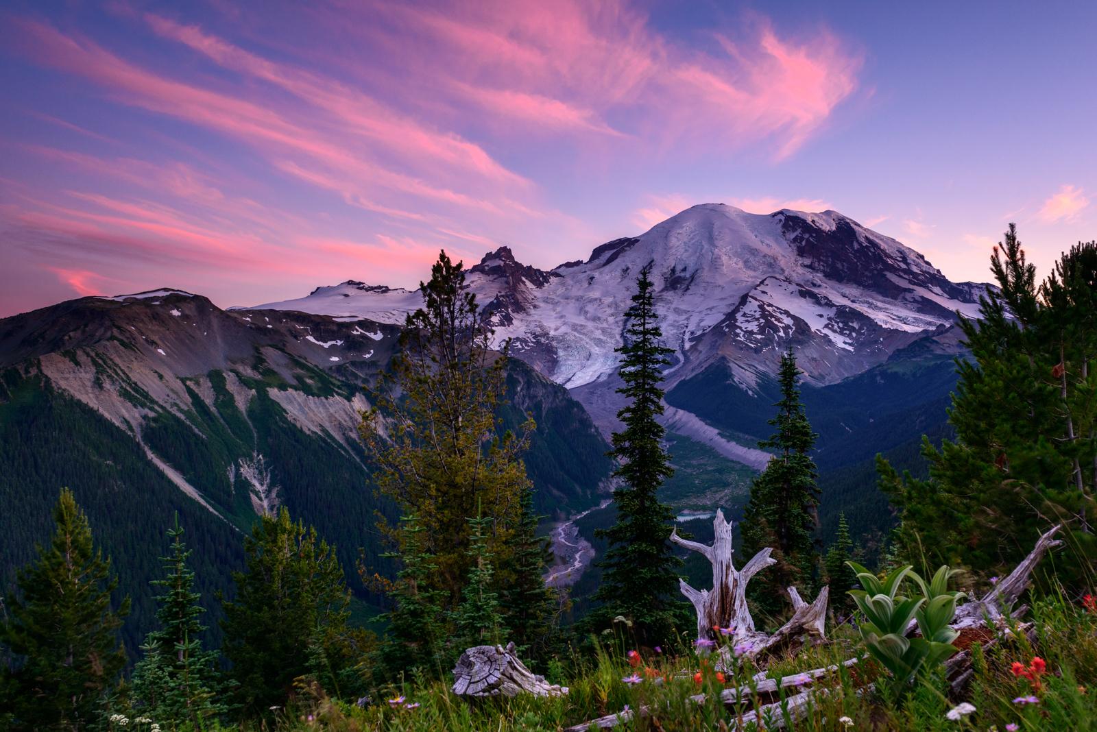
Ascending to 14,410 feet above sea level, Mount Rainier stands as an icon in the Washington landscape. An active volcano, Mount Rainier is the most glaciated peak in the contiguous U.S.A., spawning fi...

13 mi from route ~33 min detour $30 near mile 64.6
Park Closure: Paradise Road Status: Gate closed at Longmire, projected to open tomorrow
Park Closure: Starting Monday, April 13, no water available at Paradise & Narada Falls.
View on nps.gov

Park data from the National Park Service API. Alerts update every 2 hours.

Fuel & Cost

Regular Gas

$43.70 one way

$87.39 round trip

$5.33/gal 25.4 MPG avg 73 kg CO2
Fuel Type $/gal One Way Round Trip
midgrade $5.57 $45.63 $91.26
premium $5.77 $47.30 $94.61
diesel $5.64 $46.25 $92.51

No toll roads detected on this route.

Estimated Trip Cost (one way, 1 person)

Fuel

$44

Meals

$25–$50

Total

$69–$94

Rough estimate based on US averages. Hotel $80–$140/night, meals $25–$50/day.

Estimated CO2 emission: 72.8 kg one way. Prices: EIA weekly data, 2026-04-06.

Driving Electric?

About $22 in charging · 0 stops · 67% less CO2

Vehicle Type kWh Stops DC Fast Home Charge
Average EV 62.5 0 $21.86 $9.99
Efficient EV 52.1 0 $18.22 $8.33
EV Truck/SUV 83.3 1 $29.15 $13.32

Gas CO2

73 kg

EV CO2

24 kg (67% less)

This trip is well within single-charge range for most EVs. No charging stops needed if you start fully charged.

DC fast charging avg $0.35/kWh. Home charging avg $0.16/kWh. US grid CO2: 0.39 kg/kWh.

Travel Intel

Current conditions at both ends of the drive.

Forecast data refreshed 3 days ago

Origin

Yakima, WA

Late night in Yakima on Monday

Local time

2:02 AM

PDT

Current temp

34°F

Unavailable

Live forecast

Destination

Hoquiam, WA

Late night in Hoquiam on Monday

Local time

2:02 AM

PDT

Current temp

56°F

Unavailable

Live forecast

Seasonal Notes

Summer travel usually means heavier construction, hotter rest stops, and busier weekend traffic around major cities.

Winter travel shortens daylight, so a route that looks manageable on paper can feel much longer after dark.

Holiday weekends tend to make both departure and arrival windows slower than the raw route time suggests.

Time zone

Same local time

Origin and destination are on the same clock, so arrival timing is easier to judge at a glance.

Temperature spread

22 degrees warmer at arrival

A meaningful temperature swing is a good cue to rethink layers, water, and how soon you want to arrive.

Road read

4h 32m on the road

An early start around 7-8 AM gets you there with plenty of daylight left.

Weather data from the National Weather Service. Conditions may change; check closer to your travel date.

Frequently Asked Questions

The drive from Yakima, WA to Hoquiam, WA covers 208.2 miles and takes about 4h 32m without stops. Add 15-30 minutes for a fuel or rest stop on longer drives.
The main roads are US 12, US Highway 12, Sumner Avenue. Most of the drive stays on highways, so watch for ramps and exits.
This is a comfortable same-day trip.
The midpoint is about 104.1 miles from Yakima, WA. Look for rest areas, gas stations, or food options near the halfway mark.
At current regular gas prices, expect to spend about $43.70 one way. This estimate uses 25.4 MPG — your actual cost will vary with your vehicle's fuel efficiency and current gas prices.
An early start around 7-8 AM gets you there with plenty of daylight left. A late afternoon start means arriving after dark. Morning is better.
Plan about 1 meaningful break for fuel, food, or rest. Plan on a short reset every 3 to 4 hours to stay fresh behind the wheel.
This is a straightforward 4h 32m drive. You will face about 15 decision points, but nothing that requires special attention if you follow navigation.
The main spots that need attention: at 1.7 miles: Highway fork - watch signs carefully; at 157.8 miles (US 12): Lane positioning matters here; at 204.2 miles (East Market Street): Roundabout - know your exit number before entering.
Between Yakima, WA and Hoquiam, WA, road signs point toward Tenino, Montesano and Aberdeen.

Was this route helpful?

Thanks for your feedback!

Your tip has been submitted. Thanks!

/500

Explore More

Return Trip

Hoquiam, WA to Yakima, WA

Plan the drive back the other way.

207.8 mi 4h 32m

More trips to Hoquiam, WA

Explore more options from Yakima, WA or browse trips ending in Hoquiam, WA.

Looking for more statewide routes? Browse WA road trips.

Explore maps for Yakima, WA or Hoquiam, WA on MapSof.net.