Origin
Ajo, AZ
Morning in Ajo on Saturday
Local time
10:32 AM
MST
Current temp
84°F
Unavailable
Live forecast
Compiled and reviewed by the Trip.ovh planning team at COD Solutions Oy · Last reviewed Apr 18, 2026 · Editorial standards
Drive Time
2h 48m
Distance
134.7 mi
217 km
Drive Score
8/10
Great drive
Same Day?
Yes, doable
Fuel Cost
$27
one way
EV Charging
Unknown
Estimated drive times based on typical traffic patterns. Actual times may vary with weather, construction, and real-time conditions.

Ajo, AZ
Wikimedia Commons

Tucson, AZ
Wikimedia Commons
The drive from Ajo, AZ to Tucson, AZ covers 134.7 miles and takes about 2h 48m behind the wheel. This route is realistic as a one-day drive if you keep your stops efficient.
The route leans on North Tucson-Ajo Highway, West Ajo Highway, Tucson-Ajo Highway for much of the mileage, and the overall profile is mostly surface roads. The longest uninterrupted segment is about 93.7 miles on North Tucson-Ajo Highway. At current regular gas prices, budget about $26.83 one way before food or hotel costs.
Trip Pace
Same-day drive is realistic
A same-day return is realistic if you keep stops short.
Break Rhythm
1 planned break
A short stop every 2 to 3 hours is enough for this drive.
Midpoint
67.3 miles from Ajo, AZ
A natural place for your longest stop of the day , about 1h 21m into the drive .
| Road | Distance | Duration |
|---|---|---|
| North Tucson-Ajo Highway | 93.7 mi | 1h 51m |
| West Ajo Highway | 23 mi | 28m |
| Tucson-Ajo Highway | 9.7 mi | 12m |
| West 22nd Street | 1.7 mi | 2m |
| West Ajo Way | 1.2 mi | 2m |
| East Broadway Boulevard | 1 mi | 2m |
| Gila Bend-Lukeville Highway | 0.9 mi | 1m |
| Nogales–Tucson Highway | 0.7 mi | <1m |
Step-by-step road directions between Ajo, AZ and Tucson, AZ.
Start on AZ 85
Continue on AZ 85
Continue on AZ 85
Continue on AZ 85
Continue on AZ 85
Turn left onto AZ 86
Continue on AZ 86
Continue on AZ 86
Take the ramp
Merge onto I 19
Keep slight right at fork
Continue on South Freeway Road
Turn right onto West 22nd Street
Turn slight left
Turn straight onto South Kino Parkway
Continue on South Campbell Avenue
Turn right onto East Broadway Boulevard
Turn left onto North Country Club Road
Arrive at destination
Morning Departure
Leave by 9 AM and you'll arrive before lunch.
Evening Departure
Even a 4 PM departure gets you there before dark in summer.
This is a comfortable same-day trip.
Departure
Before you leave
Start with fuel, water, and navigation already sorted so the first hour feels easy.
First stop
Around 30 miles or 37m in
Use this first pause for coffee, a restroom break, and a quick traffic check ahead.
Halfway reset
Around 67.3 miles or 1h 21m in
This is the best place for your longest stop, a real meal, and a full fuel check.
Final approach
Final hour starts around 2h 13m
Traffic, exits, and arrival timing usually matter more near Tucson, AZ than in the middle of the route.
Open the route before leaving Ajo, AZ so your first major turns are already loaded.
Leave with enough water and a charging cable within reach, not packed away.
Check your fuel range against the first long segment, especially if you are starting outside city service areas.
Day 1
Settle into the route from Ajo, AZ
This is one driving day of about 134.7 miles and 2h 48m.
Rest stops, refuel points, and overnight suggestions along this route.

Mid-route town
Meal stop
67 mi into the route
Best for: Lunch, fuel, and a longer reset
This sits close to the middle of the route, so it works well for the longest stop of the day.
A short stop after about 30 miles helps settle the day before fatigue starts building.
The midpoint is around 67.3 miles from Ajo, AZ, which is a good place for a longer meal and fuel stop.
Before the longest stretch
Fuel checkTop up before North Tucson-Ajo Highway if your tank is already low. That segment runs about 93.7 miles.
These stop ideas are pacing suggestions — the exact town or exit can change with traffic, hotel plans, and fuel range.
4 decision points cluster between mile 10.8 and 133.6 — GPS handles the exact turns, but know they're coming. Your lane choice matters more than the turn itself.
Turn left onto AZ 86 / North Tucson-Ajo Highway
Navigation decision point
Merge onto I 19 / Nogales–Tucson Highway
Merge point - match speed before joining
Keep slight right at fork toward 29th Street/22nd Street, Silverlake Road, Starr Pass Boulevard
Highway fork - watch signs carefully. Lane positioning matters here. Multiple destination signs - pick the right one
Turn right onto East Broadway Boulevard
Lane positioning matters here
Regular Gas
$26.83 one way
$53.67 round trip
| Fuel Type | $/gal | One Way | Round Trip |
|---|---|---|---|
| midgrade | $5.36 | $28.40 | $56.80 |
| premium | $5.59 | $29.65 | $59.30 |
| diesel | $5.61 | $29.74 | $59.48 |
No toll roads detected on this route.
Estimated Trip Cost (one way, 1 person)
Fuel
$27
Meals
$25–$50
Total
$52–$77
Rough estimate based on US averages. Hotel $80–$140/night, meals $25–$50/day.
Estimated CO2 emission: 47.1 kg one way. Prices: EIA weekly data, 2026-04-13.
Driving Electric?
About $14 in charging · 0 stops · 66% less CO2
| Vehicle Type | kWh | Stops | DC Fast | Home Charge |
|---|---|---|---|---|
| Average EV | 40.4 | 0 | $14.14 | $6.47 |
| Efficient EV | 33.7 | 0 | $11.79 | $5.39 |
| EV Truck/SUV | 53.9 | 0 | $18.86 | $8.62 |
Gas CO2
47 kg
EV CO2
16 kg (66% less)
This trip is well within single-charge range for most EVs. No charging stops needed if you start fully charged.
DC fast charging avg $0.35/kWh. Home charging avg $0.16/kWh. US grid CO2: 0.39 kg/kWh.
Current conditions at both ends of the drive.
Origin
Morning in Ajo on Saturday
Local time
10:32 AM
MST
Current temp
84°F
Unavailable
Destination
Morning in Tucson on Saturday
Local time
10:32 AM
MST
Current temp
54°F
Unavailable
Seasonal Notes
Summer travel usually means heavier construction, hotter rest stops, and busier weekend traffic around major cities.
Winter travel shortens daylight, so a route that looks manageable on paper can feel much longer after dark.
Holiday weekends tend to make both departure and arrival windows slower than the raw route time suggests.
Time zone
Origin and destination are on the same clock, so arrival timing is easier to judge at a glance.
Temperature spread
A meaningful temperature swing is a good cue to rethink layers, water, and how soon you want to arrive.
Road read
Use the two city cards together: check the sky where you start, then compare it with the local time and temperature at arrival.
Weather data from the National Weather Service. Conditions may change; check closer to your travel date.
Worth a detour if your schedule allows.

National Park
Tucson, Arizona is home to the nation's largest cacti. The giant saguaro is the universal symbol of the American west. These majestic plants, found only in a small portion of the United States, are pr...
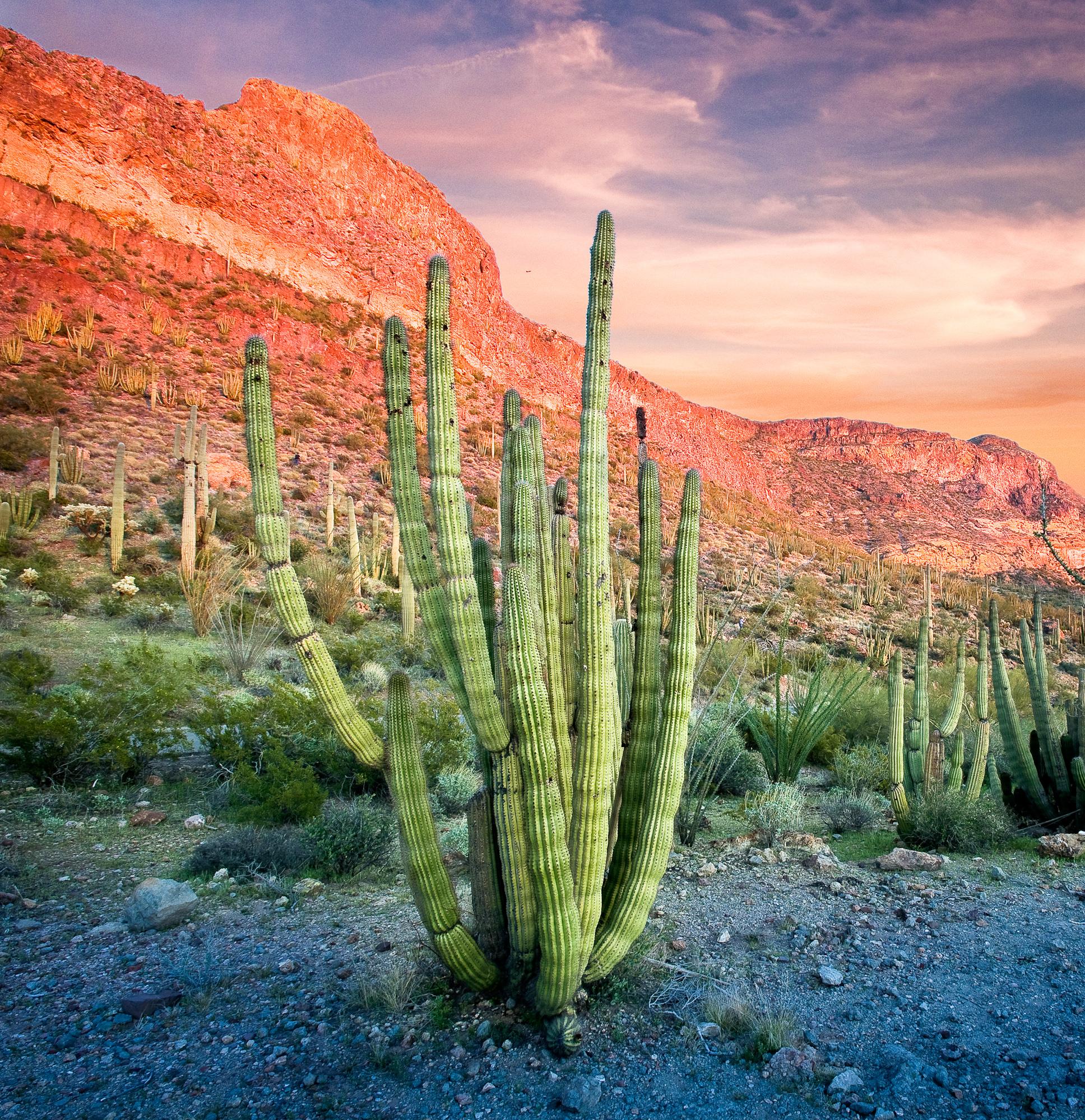
National Monument
Look closely. Look again. The sights and sounds of Organ Pipe Cactus National Monument, an International Biosphere Reserve, reveal a thriving community of plants and animals. Human stories echo throug...
Park data from the National Park Service API. Alerts update every 2 hours.
134.7 mi in 2h 48m across surface roads — expect steady turns and local traffic rather than long highway runs.
Expect a hands-on drive with frequent turns and local roads rather than long highway stretches. There are only a few real navigation decisions along the way. The trickiest moment comes around 10.8 miles in near AZ 86 / North Tucson-Ajo Highway.
Easy - simple navigation with a manageable amount of wheel time
Balances navigation complexity with total wheel time.
This is a straightforward 2h 48m drive. You will face about 4 decision points, but nothing that requires special attention if you follow navigation.
Where does it get tricky?
The main spots that need attention: at 10.8 miles (AZ 86 / North Tucson-Ajo Highway): Navigation decision point; at 129.1 miles (I 19 / Nogales–Tucson Highway): Merge point - match speed before joining; at 129.8 miles: Highway fork - watch signs carefully. Lane positioning matters here. Multiple destination signs - pick the right one.
Tucson (TOO-sawn), also known as the "Old Pueblo", is the second-largest city in the state of Arizona and the county seat of Pima County in the Sonoran Desert. It is at a higher elevation than nearby Phoenix and is correspondingly cooler. Although with half a million residents it is smaller than the capital city, its cultural life is just as vibrant.
City content from Wikivoyage (CC BY-SA 4.0) and Wikidata (CC0).
Weekend Trip
Doable as a same-day drive at 2h 48m. Total distance: 134.7 miles.
Family Friendly
Moderate complexity with 1 natural rest stops along the way.
Solo Traveler
2h 48m drive, comfortable solo distance.
First-Time Driver
Mostly highway driving (1%). Straightforward navigation.
Scenic Drive
Mostly surface roads route profile with national parks nearby.
Compiled by the Trip.ovh planning team at COD Solutions Oy from open government datasets — OSRM over OpenStreetMap for geometry, EIA for fuel prices, and NPS for national parks. See our methodology for refresh cadence and limitations.
Was this helpful?
Thanks for your feedback!
Your tip has been submitted. Thanks!
/500
Recent Tips
·
Explore more options from Ajo, AZ or browse trips ending in Tucson, AZ.
Looking for more statewide routes? Browse AZ road trips.