Trip from Cherryfield, ME to City of Portland, ME

Drive Time

4h 7m

Distance

171.4 mi

276 km

Drive Score

9/10

Great drive

Same Day?

Yes, doable

Fuel Cost

$27

one way

EV Charging

Excellent

24 DC fast

Best Time to Leave

Save up to 39 min
4 AM
3h 55m ★
6 AM
4h 8m
8 AM
4h 34m
10 AM
4h 17m
12 PM
4h 14m
3 PM
4h 18m
5 PM
4h 33m
8 PM
4h 0m

Estimated drive times based on typical traffic patterns. Actual times may vary with weather, construction, and real-time conditions.

Downtown City of Portland, ME, ME

City of Portland, ME

Brett Sayles

Trip Overview

The drive from Cherryfield, ME to City of Portland, ME covers 171.4 miles and takes about 4h 7m behind the wheel. This route is realistic as a one-day drive if you keep your stops efficient.

The route leans on I 295, Belfast Augusta Road, Route 1 for much of the mileage, and the overall profile is turn-heavy local drive. The longest uninterrupted segment is about 46.5 miles on I 295. At current regular gas prices, budget about $27.44 one way before food or hotel costs.

Trip Pace

Same-day drive is realistic

A same-day return is possible, but it will make for a full day on the road.

Break Rhythm

1 planned break

Plan on a short reset every 3 to 4 hours to stay fresh behind the wheel.

Midpoint

85.7 miles from Cherryfield, ME

A natural place for your longest stop of the day , about 2h into the drive .

Drive Character

Expect a 4h 7m drive with frequent turns across 171.4 miles of local and secondary roads.

This route has more turning and local-road decision points than a simple highway run.
There are about 56 navigation steps in the underlying route data, so the final approach matters more than the middle miles.
I 295 is the longest continuous segment at about 46.5 miles.

How Hard Is This Drive?

Expect a hands-on drive with frequent turns and local roads rather than long highway stretches. This route has several spots where lane changes, forks, or exits need your full attention. The trickiest moment comes around 28.3 miles in near Foster Street.

Route Complexity 10/10

High effort - long or complex enough to need steady focus all day

This is a demanding drive. With 23 significant decision points across 171.4 miles, you will need to stay alert — especially through interchange areas and urban stretches. Consider splitting it into segments if you are not comfortable with fast highway navigation.

Where does it get tricky?

The main spots that need attention: at 28.3 miles (Foster Street): Lane positioning matters here; at 48.5 miles (US 1; ME 3 / Route 1): Lane positioning matters here; at 113.4 miles: Highway fork - watch signs carefully. Multiple destination signs - pick the right one.

Critical Maneuvers

5 of 23 key points

These are the spots where you need to pay the most attention. Preview them before you drive.

5
28.3 mi into trip | ~49m in | Foster Street

Turn left onto Foster Street

Lane positioning matters here

Use the left lane.
7
48.5 mi into trip | ~1h 13m in | US 1; ME 3 / Route 1

Turn left onto US 1; ME 3 / Route 1

Lane positioning matters here

Use the left lane.
6
113.4 mi into trip | ~2h 39m in

Keep slight left at fork toward I-95 South: Portland, Kittery

Highway fork - watch signs carefully. Multiple destination signs - pick the right one

Toward I-95 South: Portland, Kittery
9
119.9 mi into trip | ~2h 46m in | I 295

Keep slight right at fork onto I 295 toward I 295 South, ME 9, ME 126: Gardiner, Brunswick

Highway fork - watch signs carefully. Lane positioning matters here. Multiple destination signs - pick the right one

Use the straight lane. Exit 103 Toward I 295 South, ME 9, ME 126: Gardiner, Bru...
7
166.4 mi into trip | ~3h 39m in | US 1A

Take the exit onto US 1A toward US 1A

Exit ramp - move to the correct lane early. Lane positioning matters here

Use the straight / slight right lanes. Exit 7 Toward US 1A

Towns Along This Route

Between Cherryfield, ME and City of Portland, ME, road signs point toward Waterville, Bangor, Kittery and Brunswick.

Waterville

113 mi in | ~2h 38m

Bangor

113 mi in | ~2h 38m

Kittery

113.4 mi in | ~2h 39m

Brunswick

119.9 mi in | ~2h 46m | via I 295

Main Roads

Road Distance Duration
I 295 46.5 mi 52m
Belfast Augusta Road 17.6 mi 21m
Route 1 15.2 mi 18m
Acadia Highway 13.4 mi 15m
Blackswoods Road 12.5 mi 21m
North Belfast Avenue 9.1 mi 13m
Bucksport Road 8.5 mi 9m
Maine Turnpike 5.9 mi 6m
Longest stretch: I 295 — 46.5 mi, about 52m

Turn-by-Turn Driving Directions

Step-by-step road directions between Cherryfield, ME and City of Portland, ME.

1

Start on Willey District Road

160 ft · 4 sec · Willey District Road
2

Continue on North Street

0.7 mi · 1 min · North Street
3

Turn right onto ME 182

4.0 mi · 7 min · Blacks Woods Road
4

Continue on ME 182

12 mi · 21 min · Blackswoods Road
5

Continue on ME 182; ME 200

0.9 mi · 1 min · Main Street
6

Continue on ME 182

5.1 mi · 9 min · West Franklin Road
7

At end of road, turn right onto US 1

3.6 mi · 5 min · US Highway 1
8

Continue on US 1

1.1 mi · 1 min · Downeast Highway
9

Keep slight right at fork onto US 1; ME 3

459 ft · 11 sec · Downeast Highway
10

Continue on US 1; ME 3

0.2 mi · 35 sec · High Street
11

Turn left onto Foster Street

0.4 mi · 1 min · Foster Street
Use the left lane.
12

At end of road, turn right onto ME 230

0.7 mi · 1 min · Water Street
13

Turn left onto US 1; ME 3

0.2 mi · 10 sec · West Main Street
14

Keep slight right at fork onto US 1; ME 3

278 ft · 3 sec · Main Street
15

Continue on US 1; ME 3

8.5 mi · 9 min · Bucksport Road
16

Continue on US 1; ME 3

9.4 mi · 10 min · Acadia Highway
17

Continue on US 1; ME 3; ME 15

1.0 mi · 1 min · Route 1
18

Continue on US 1; ME 3; ME 15

135 ft · 9 sec · Main Street
Use the left lane.
19

Turn left onto US 1; ME 3

0.1 mi · 16 sec · Route 1
Use the left lane.
20

Continue on US 1; ME 3

1.2 mi · 2 min · US Highway 1
21

Continue on US 1; ME 3

13 mi · 15 min · Route 1
22

Continue on US 1; ME 3

2.7 mi · 4 min · Searsport Avenue
23

Continue on US 1; ME 3

0.7 mi · 1 min · Route 1
24

Take the exit onto ME 3

0.3 mi · 38 sec · ME 3
25

Keep slight right at fork onto ME 3

373 ft · 12 sec · ME 3
26

Merge onto ME 3

3.9 mi · 4 min · Belmont Avenue
Use the straight lane.
27

Continue on ME 3

4.8 mi · 5 min · Augusta Road
28

Continue on ME 3

3.4 mi · 3 min · Belfast Augusta Road East
29

Continue on ME 3

4.0 mi · 4 min · Acadia Highway
30

Continue on ME 3

18 mi · 21 min · Belfast Augusta Road
Use the straight lane.
31

Continue on US 202; ME 3; ME 9

0.2 mi · 16 sec · Belfast Road
32

Continue on US 202; ME 3; ME 9

8.1 mi · 11 min · North Belfast Avenue
33

Turn left onto US 202; ME 9

1.0 mi · 1 min · North Belfast Avenue
Use the left lane.
34

At end of road, turn left onto US 201; US 202; ME 9; ME 100

0.6 mi · 52 sec · Bangor Street
35

Enter roundabout onto US 201; US 202; ME 17; ME 100

159 ft · 3 sec · Memorial Drive
36

Continue on US 201; US 202; ME 17; ME 100

0.7 mi · 1 min · Memorial Drive
37

Enter roundabout onto US 201; ME 27

401 ft · 7 sec · State Street
38

Continue on US 201; ME 27

0.2 mi · 19 sec · State Street
39

Turn right onto Capitol Street

0.8 mi · 1 min · Capitol Street
40

Turn straight onto Armory Street

0.2 mi · 20 sec · Armory Street
41

Turn left onto US 202; ME 11; ME 17; ME 100

0.7 mi · 1 min · Western Avenue
42

Take the exit

0.3 mi · 44 sec
Toward I 95: Portland, Waterville, Bangor
43

Keep slight left at fork

0.6 mi · 1 min
Toward I-95 South: Portland, Kittery
44

Merge onto I 95

5.9 mi · 6 min · Maine Turnpike
45

Keep slight right at fork onto I 295

46 mi · 52 min · I 295
Exit 103 Toward I 295 South, ME 9, ME 126: Gardiner, Brunswick Use the straight lane.
46

Take the exit onto US 1A

1.1 mi · 2 min · US 1A
Exit 7 Toward US 1A Use the straight / slight right lanes.
47

Continue on Maine State Pier

0.1 mi · 29 sec · Maine State Pier
Use the straight lane.
48

Turn slight right

187 ft · 13 sec
49

Turn straight onto Portland - Peaks Island

2.5 mi · 20 min · Portland - Peaks Island
50

Continue

213 ft · 15 sec
51

Continue on Welch Street

0.2 mi · 49 sec · Welch Street
52

Turn right onto Oakland Avenue

0.1 mi · 26 sec · Oakland Avenue
53

Turn slight left onto Whitehead Street

351 ft · 15 sec · Whitehead Street
54

Continue on Seashore Avenue

0.2 mi · 46 sec · Seashore Avenue
55

Continue on Seashore Avenue

0.6 mi · 2 min · Seashore Avenue
56

Arrive at destination

Seashore Avenue

Trip Plan

Morning Departure

An early start around 7-8 AM gets you there with plenty of daylight left.

Evening Departure

A late afternoon start means arriving after dark. Morning is better.

You can normally do this drive in one day.
Plan roughly 1 meaningful break for fuel, food, and rest.
The halfway point lands around 85.7 miles from Cherryfield, ME, or about 2h into the drive.
The longest continuous stretch on this route runs about 46.5 miles.

This is a comfortable same-day trip.

Departure

Before you leave

Start with fuel, water, and navigation already sorted so the first hour feels easy.

First stop

Around 80 miles or 1h 54m in

Use this first pause for coffee, a restroom break, and a quick traffic check ahead.

Halfway reset

Around 85.7 miles or 2h in

This is the best place for your longest stop, a real meal, and a full fuel check.

Final approach

Final hour starts around 3h 10m

Traffic, exits, and arrival timing usually matter more near City of Portland, ME than in the middle of the route.

Before You Leave

+

Open the route before leaving Cherryfield, ME so your first major turns are already loaded.

+

Leave with enough water and a charging cable within reach, not packed away.

+

Check your fuel range against the first long segment, especially if you are starting outside city service areas.

Day 1

Settle into the route from Cherryfield, ME

This is one driving day of about 171.4 miles and 4h 7m.

Your first comfortable stop window is around 80 miles from Cherryfield, ME.
This route can stay practical as a one-day drive if traffic stays reasonable.
Plan about 1 real break rather than only quick fuel stops.
The longest stretch is on I 295 for about 46.5 miles.

Where to Stop

Rest stops, refuel points, and overnight suggestions along this route.

Halfway Point

Midpoint

About 85.7 mi from Cherryfield, ME · 2h into the drive

Downtown Brunswick, ME, ME

Mid-route town

Meal stop

Brunswick, ME

86 mi into the route

Best for: Lunch, fuel, and a longer reset

This sits close to the middle of the route, so it works well for the longest stop of the day.

Popular next leg

Brunswick, ME to City of Portland, ME

30.3 mi · 1h 1m

Pacing Suggestions

Brunswick, ME

Fuel and coffee

A short stop after about 80 miles helps settle the day before fatigue starts building.

Brunswick, ME

Meal break

The midpoint is around 85.7 miles from Cherryfield, ME, which is a good place for a longer meal and fuel stop.

Arriving in City of Portland, ME

The final approach into City of Portland, ME usually feels slower than the middle of the drive, so avoid planning your tightest schedule at the very end.

Try to arrive with enough fuel left to skip an immediate station stop unless you already know the area around City of Portland, ME.

These stop ideas are pacing suggestions — the exact town or exit can change with traffic, hotel plans, and fuel range.

National Parks Near This Route

Worth a detour if your schedule allows.

Acadia National Park

Acadia National Park

National Park

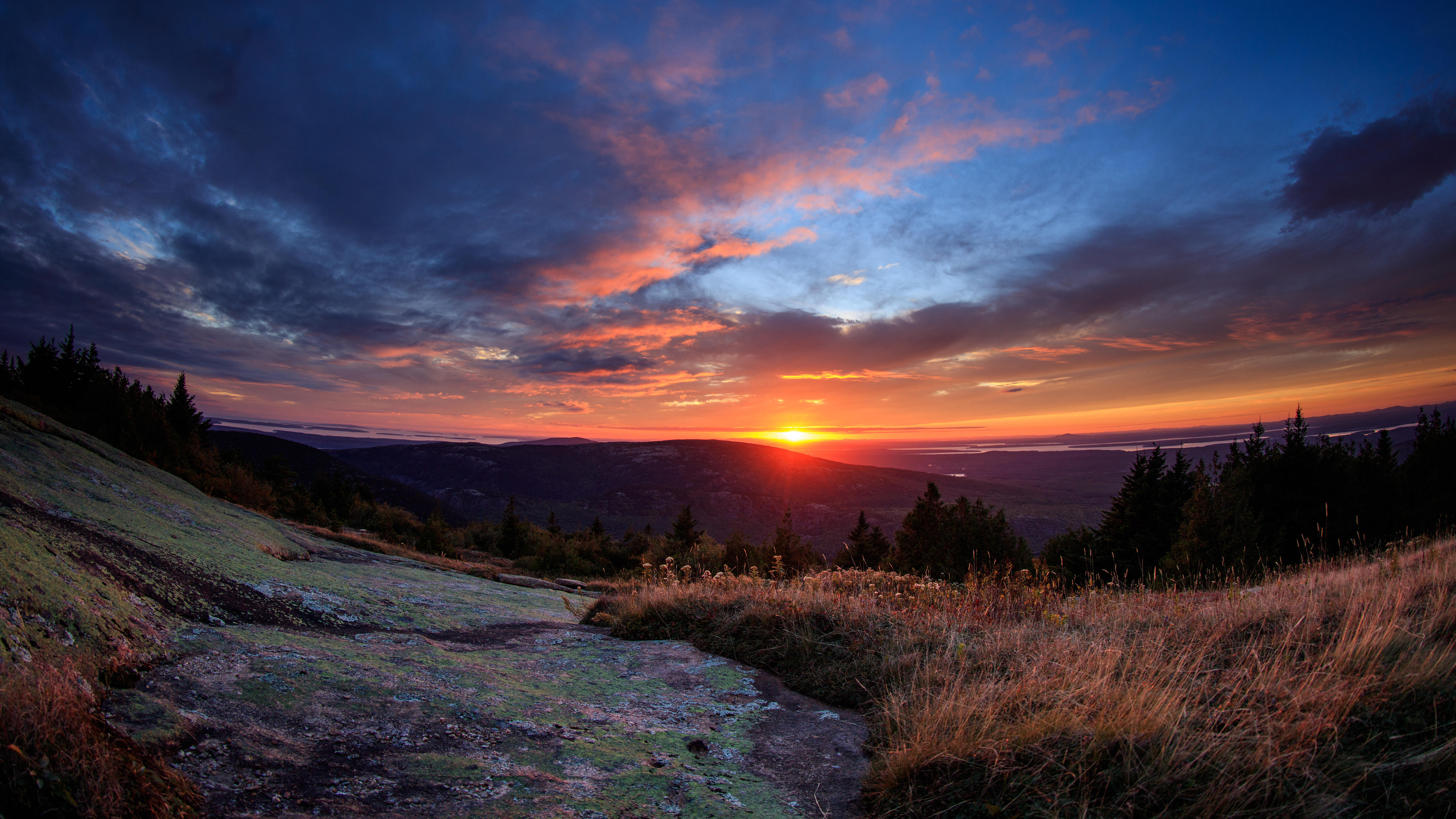
Acadia National Park protects the natural beauty of the highest rocky headlands along the Atlantic coastline of the United States, an abundance of habitats, and a rich cultural heritage. At 4 million...

10 mi from route ~24 min detour $6 near mile 23.6
Park Closure: Cadillac Summit Road Closed for Construction
Park Closure: Park Loop Road to Kebo Street Closed for Construction
View on nps.gov
Frances Perkins National Monument

Frances Perkins National Monument

National Monument

Known as the first woman to hold a presidential cabinet position and the “Woman behind the New Deal,” Frances Perkins championed many labor rights that Americans enjoy today, including safety standard...

17 mi from route ~42 min detour Free near mile 130
View on nps.gov

Park data from the National Park Service API. Alerts update every 2 hours.

Fuel & Cost

Regular Gas

$27.44 one way

$54.87 round trip

$4.07/gal 25.4 MPG avg 60 kg CO2
Fuel Type $/gal One Way Round Trip
midgrade $4.46 $30.08 $60.15
premium $4.83 $32.58 $65.16
diesel $5.64 $38.08 $76.16

Estimated Tolls: $0.36

Maine Turnpike (5.9 mi) $0.36

Toll estimates based on average 2024-2025 rates. EZ-Pass/SunPass discounts may lower the actual cost.

Estimated Trip Cost (one way, 1 person)

Fuel

$27

Tolls

$0

Meals

$25–$50

Total

$53–$78

Rough estimate based on US averages. Hotel $80–$140/night, meals $25–$50/day.

Estimated CO2 emission: 60 kg one way. Prices: EIA weekly data, 2026-04-06.

EV Charging Along Route

24 DC fast chargers · Coverage: excellent

Augusta Comfort Inn Civic Center - Tesla Supercharger

Augusta, ME

Tesla

16 DCFC

Maine Coast Mall - Tesla Supercharger

Ellsworth, ME

Tesla

8 DCFC

Marketplace at Augusta - Tesla Supercharger

Augusta, ME

Tesla

8 DCFC

Sundog FastCharge

Searsport, ME

Non-Networked

4 DCFC

Quirk Ford of Augusta

Hallowell, ME

FORD_CHARGE

4 DCFC

11 Seahawk Ave Parking Lot

Brunswick, ME

Non-Networked

4 DCFC

Quirk Ford of Belfast

Belfast, ME

FORD_CHARGE

2 DCFC

Shuman Motors, Inc

Augusta, ME

Blink Network

2 DCFC

ChargePoint Network: 13 Non-Networked: 4 Tesla: 3 FORD_CHARGE: 2 Blink Network: 1 eVgo Network: 1

Station data from NREL Alternative Fuel Stations database.

Driving Electric?

About $18 in charging · 0 stops · 67% less CO2

Vehicle Type kWh Stops DC Fast Home Charge
Average EV 51.4 0 $18.00 $8.23
Efficient EV 42.9 0 $15.00 $6.86
EV Truck/SUV 68.6 0 $24.00 $10.97

Gas CO2

60 kg

EV CO2

20 kg (67% less)

This trip is well within single-charge range for most EVs. No charging stops needed if you start fully charged.

DC fast charging avg $0.35/kWh. Home charging avg $0.16/kWh. US grid CO2: 0.39 kg/kWh.

Travel Intel

Current conditions at both ends of the drive.

Forecast data refreshed 3 days ago

Origin

Cherryfield, ME

Afternoon in Cherryfield on Monday

Local time

1:34 PM

EDT

Current temp

39°F

Unavailable

Live forecast

Destination

City of Portland, ME

Afternoon in City of Portland on Monday

Local time

1:34 PM

EDT

Current temp

43°F

Unavailable

Live forecast

Along the Route

43°F

Brunswick, ME

86 mi in

Seasonal Notes

Summer travel usually means heavier construction, hotter rest stops, and busier weekend traffic around major cities.

Winter travel shortens daylight, so a route that looks manageable on paper can feel much longer after dark.

Holiday weekends tend to make both departure and arrival windows slower than the raw route time suggests.

Time zone

Same local time

Origin and destination are on the same clock, so arrival timing is easier to judge at a glance.

Temperature spread

4 degrees warmer at arrival

A meaningful temperature swing is a good cue to rethink layers, water, and how soon you want to arrive.

Road read

4h 7m on the road

An early start around 7-8 AM gets you there with plenty of daylight left.

Weather data from the National Weather Service. Conditions may change; check closer to your travel date.

Frequently Asked Questions

The drive from Cherryfield, ME to City of Portland, ME covers 171.4 miles and takes about 4h 7m without stops. Add 15-30 minutes for a fuel or rest stop on longer drives.
The main roads are I 295, Belfast Augusta Road, Route 1. Expect a mix of highway and local road driving.
This is a comfortable same-day trip.
The midpoint is about 85.7 miles from Cherryfield, ME. Look for rest areas, gas stations, or food options near the halfway mark.
At current regular gas prices, expect to spend about $27.44 one way. This estimate uses 25.4 MPG — your actual cost will vary with your vehicle's fuel efficiency and current gas prices.
An early start around 7-8 AM gets you there with plenty of daylight left. A late afternoon start means arriving after dark. Morning is better.
Plan about 1 meaningful break for fuel, food, or rest. Plan on a short reset every 3 to 4 hours to stay fresh behind the wheel.
This is a demanding drive. With 23 significant decision points across 171.4 miles, you will need to stay alert — especially through interchange areas and urban stretches. Consider splitting it into segments if you are not comfortable with fast highway navigation.
The main spots that need attention: at 28.3 miles (Foster Street): Lane positioning matters here; at 48.5 miles (US 1; ME 3 / Route 1): Lane positioning matters here; at 113.4 miles: Highway fork - watch signs carefully. Multiple destination signs - pick the right one.
Between Cherryfield, ME and City of Portland, ME, road signs point toward Waterville, Bangor, Kittery and Brunswick.

Was this route helpful?

Thanks for your feedback!

Your tip has been submitted. Thanks!

/500

Explore More

Explore more options from Cherryfield, ME or browse trips ending in City of Portland, ME.

Looking for more statewide routes? Browse ME road trips.

Explore maps for Cherryfield, ME or City of Portland, ME on MapSof.net.