
Trip from Deltaville, VA to Alexandria, VA

Last recalculated Apr 16, 2026

Drive Time

3h 10m

Distance

132.8 mi

214 km

Drive Score

8/10

Great drive

Same Day?

Yes, doable

Fuel Cost

$21

one way

EV Charging

Unknown

Best Time to Leave

Save up to 35 min
4 AM
2h 59m ★
6 AM
3h 11m
8 AM
3h 34m
10 AM
3h 19m
12 PM
3h 17m
3 PM
3h 20m
5 PM
3h 33m
8 PM
3h 4m

Estimated drive times based on typical traffic patterns. Actual times may vary with weather, construction, and real-time conditions.

Downtown Deltaville, VA, VA

Deltaville, VA

Eric Joseph

Downtown Alexandria, VA, VA

Alexandria, VA

Wikimedia Commons

Trip Overview

The drive from Deltaville, VA to Alexandria, VA covers 132.8 miles and takes about 3h 10m behind the wheel. This route is realistic as a one-day drive if you keep your stops efficient.

The route leans on Tidewater Trail, Nice Middleton Bridge, General Puller Highway for much of the mileage, and the overall profile is turn-heavy local drive. The longest uninterrupted segment is about 54.2 miles on Tidewater Trail. At current regular gas prices, budget about $20.77 one way before food or hotel costs.

Trip Pace

Same-day drive is realistic

A same-day return is realistic if you keep stops short.

Break Rhythm

1 planned break

A short stop every 2 to 3 hours is enough for this drive.

Midpoint

66.4 miles from Deltaville, VA

A natural place for your longest stop of the day , about 1h 31m into the drive .

Who Is This Route For?

Weekend Trip

Doable as a same-day drive at 3h 10m. Total distance: 132.8 miles.

Family Friendly

Moderate complexity with 1 natural rest stops along the way.

Solo Traveler

3h 10m drive, comfortable solo distance.

Scenic Drive

Turn-heavy local drive route profile with national parks nearby.

Drive Character

Expect a 3h 10m drive with frequent turns across 132.8 miles of local and secondary roads.

This route has more turning and local-road decision points than a simple highway run.
There are about 23 navigation steps in the underlying route data, so the final approach matters more than the middle miles.
Tidewater Trail is the longest continuous segment at about 54.2 miles.

How Hard Is This Drive?

Expect a hands-on drive with frequent turns and local roads rather than long highway stretches. You will hit about 11 points where you need to pay attention to lane position or signs. The trickiest moment comes around 72.3 miles in near US 301 / A.P. Hill Boulevard.

Driving Effort 6/10

Moderate - straightforward overall, but long enough or busy enough to require pacing

Balances navigation complexity with total wheel time.

This drive requires moderate attention. Across 132.8 miles you will encounter 11 spots where lane choice or exit timing matters. Not difficult for experienced highway drivers, but worth previewing the tricky sections before you go.

Where does it get tricky?

The main spots that need attention: at 72.3 miles (US 301 / A.P. Hill Boulevard): Navigation decision point; at 111.3 miles (Middletown Road): Roundabout - know your exit number before entering; at 128.6 miles: Exit ramp - move to the correct lane early. Lane positioning matters here. Multiple destination signs - pick the right one.

Critical Maneuvers

5 of 11 key points

These are the spots where you need to pay the most attention. Preview them before you drive.

4
72.3 mi into trip | ~1h 38m in | US 301 / A.P. Hill Boulevard

Turn right onto US 301 / A.P. Hill Boulevard toward Baltimore

Navigation decision point

Toward Baltimore
4
111.3 mi into trip | ~2h 36m in | Middletown Road

Enter roundabout onto Middletown Road

Roundabout - know your exit number before entering

7
128.6 mi into trip | ~3h 2m in

Take the exit toward I 95 South, I 495 South: Alexandria, Richmond

Exit ramp - move to the correct lane early. Lane positioning matters here. Multiple destination signs - pick the right one

Use the straight / slight right lanes. Toward I 95 South, I 495 South: Alexandria, Ric...
8
131.7 mi into trip | ~3h 7m in

Take the exit toward US 1 North: Alexandria, Mount Vernon

Exit ramp - move to the correct lane early. Lane positioning matters here. Multiple destination signs - pick the right one

Use the straight / slight right lanes. Exit 177B; 177C Toward US 1 North: Alexandria, Mount Vernon
9
131.9 mi into trip | ~3h 7m in

Keep slight right at fork toward Mount Vernon

Highway fork - watch signs carefully. Lane positioning matters here

Use the slight right lane. Exit 177C Toward Mount Vernon

Towns Mentioned on Route Signs

Based on OSRM destination-sign hints, not a full list of every settlement the road passes.

On the drive from Deltaville, VA to Alexandria, VA, road signs begin pointing toward Baltimore along the way.

Baltimore

72.3 mi in | ~1h 38m | via US 301

Main Roads

Road Distance Duration
Tidewater Trail 54.2 mi 1h 10m
Nice Middleton Bridge 17.6 mi 25m
General Puller Highway 17.4 mi 26m
James Madison Parkway 17.1 mi 23m
Indian Head Highway 10.2 mi 14m
Middletown Road 4.2 mi 7m
Berry Road 3.9 mi 6m
Capital Beltway (Local) 2.9 mi 3m
Longest stretch: Tidewater Trail — 54.2 mi, about 1h 10m

Turn-by-Turn Driving Directions

Step-by-step road directions between Deltaville, VA and Alexandria, VA.

1

Start on VA 33

17 mi · 26 min · General Puller Highway
2

Turn right onto US 17

28 mi · 37 min · Tidewater Trail
3

Continue on US 17

0.7 mi · 1 min · Church Lane
4

Continue on US 17

26 mi · 32 min · Tidewater Trail
5

Turn right onto US 301

0.4 mi · 53 sec · A.P. Hill Boulevard
Toward Baltimore
6

Continue on US 301

0.7 mi · 1 min · Main Street
7

Continue on US 301

17 mi · 23 min · James Madison Parkway
Use the straight lane.
8

Continue on US 301

18 mi · 25 min · Nice Middleton Bridge
Use the straight lane.
9

Take the exit

277 ft · 7 sec
10

Continue on Turkey Hill Road

2.1 mi · 5 min · Turkey Hill Road
11

Continue on Middletown Road

1.1 mi · 1 min · Middletown Road
12

Enter roundabout onto Middletown Road

158 ft · 3 sec · Middletown Road
13

Continue on Middletown Road

3.1 mi · 5 min · Middletown Road
Use the straight lane.
14

Turn left onto MD 228

3.9 mi · 6 min · Berry Road
15

Continue on MD 210

10 mi · 14 min · Indian Head Highway
Use the straight / slight right lanes.
16

Take the exit

0.1 mi · 19 sec
Toward I 95 South, I 495 South: Alexandria, Richmond Use the straight / slight right lanes.
17

Continue on this road

516 ft · 12 sec · this road
Toward I 95 South, I 495 South: Alexandria, Richmond
18

Merge onto I 95; I 495

2.9 mi · 3 min · Capital Beltway (Local)
19

Take the exit

0.2 mi · 25 sec
Exit 177B; 177C Toward US 1 North: Alexandria, Mount Vernon Use the straight / slight right lanes.
20

Keep slight right at fork

0.1 mi · 15 sec
Exit 177C Toward Mount Vernon Use the slight right lane.
21

Turn straight onto Church Street

321 ft · 18 sec · Church Street
22

Turn left onto VA 400

0.7 mi · 2 min · South Washington Street
23

Arrive at destination

VA 400

Trip Plan

Morning Departure

An early start around 7-8 AM gets you there with plenty of daylight left.

Evening Departure

A late afternoon start means arriving after dark. Morning is better.

You can normally do this drive in one day.
Plan roughly 1 meaningful break for fuel, food, and rest.
The halfway point lands around 66.4 miles from Deltaville, VA, or about 1h 31m into the drive.
The longest continuous stretch on this route runs about 54.2 miles.

This is a comfortable same-day trip.

Departure

Before you leave

Start with fuel, water, and navigation already sorted so the first hour feels easy.

First stop

Around 29 miles or 42m in

Use this first pause for coffee, a restroom break, and a quick traffic check ahead.

Halfway reset

Around 66.4 miles or 1h 31m in

This is the best place for your longest stop, a real meal, and a full fuel check.

Final approach

Final hour starts around 2h 31m

Traffic, exits, and arrival timing usually matter more near Alexandria, VA than in the middle of the route.

Before You Leave

+

Open the route before leaving Deltaville, VA so your first major turns are already loaded.

+

Leave with enough water and a charging cable within reach, not packed away.

+

Check your fuel range against the first long segment, especially if you are starting outside city service areas.

Day 1

Settle into the route from Deltaville, VA

This is one driving day of about 132.8 miles and 3h 10m.

Your first comfortable stop window is around 29 miles from Deltaville, VA.
This route can stay practical as a one-day drive if traffic stays reasonable.
Plan about 1 real break rather than only quick fuel stops.
The longest stretch is on Tidewater Trail for about 54.2 miles.

Where to Stop

Rest stops, refuel points, and overnight suggestions along this route.

Halfway Point

Midpoint

About 66.4 mi from Deltaville, VA · 1h 31m into the drive

town in Westmoreland County, Virginia, United States

Mid-route town

Meal stop

Colonial Beach, VA

66 mi into the route

Best for: Lunch, fuel, and a longer reset

This sits close to the middle of the route, so it works well for the longest stop of the day.

Pacing Suggestions

Warsaw, VA

Fuel and coffee

A short stop after about 29 miles helps settle the day before fatigue starts building.

Colonial Beach, VA

Meal break

The midpoint is around 66.4 miles from Deltaville, VA, which is a good place for a longer meal and fuel stop.

Arriving in Alexandria, VA

The final approach into Alexandria, VA usually feels slower than the middle of the drive, so avoid planning your tightest schedule at the very end.

Try to arrive with enough fuel left to skip an immediate station stop unless you already know the area around Alexandria, VA.

These stop ideas are pacing suggestions — the exact town or exit can change with traffic, hotel plans, and fuel range.

National Parks Near This Route

Worth a detour if your schedule allows.

George Washington Birthplace National Monument

George Washington Birthplace National Monument

National Monument

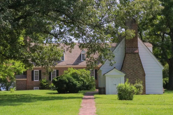
George Washington Birthplace National Monument is located in the Northern Neck of Virginia. It encompasses 551 acres of land where seven generations of the Washington family lived and where George Was...

10 mi from route ~25 min detour Free near mile 59.5
View on nps.gov
Colonial National Historical Park

Colonial National Historical Park

National Historical Park

On May 13, 1607, Jamestown was established as the first permanent English settlement in North America. Three cultures came together – European, Virginia Indian and African–to create a new society that...

25 mi from route ~62 min detour $15 near mile 4.6
View on nps.gov

Park data from the National Park Service API. Alerts update every 2 hours.

Fuel & Cost

Regular Gas

$20.77 one way

$41.53 round trip

$3.97/gal 25.4 MPG avg 47 kg CO2
Fuel Type $/gal One Way Round Trip
midgrade $4.34 $22.71 $45.41
premium $4.70 $24.58 $49.16
diesel $5.61 $29.32 $58.64

No toll roads detected on this route.

Estimated Trip Cost (one way, 1 person)

Fuel

$21

Meals

$25–$50

Total

$46–$71

Rough estimate based on US averages. Hotel $80–$140/night, meals $25–$50/day.

Estimated CO2 emission: 46.5 kg one way. Prices: EIA weekly data, 2026-04-13.

Driving Electric?

About $14 in charging · 0 stops · 65% less CO2

Vehicle Type kWh Stops DC Fast Home Charge
Average EV 39.8 0 $13.94 $6.37
Efficient EV 33.2 0 $11.62 $5.31
EV Truck/SUV 53.1 0 $18.59 $8.50

Gas CO2

46 kg

EV CO2

16 kg (65% less)

This trip is well within single-charge range for most EVs. No charging stops needed if you start fully charged.

DC fast charging avg $0.35/kWh. Home charging avg $0.16/kWh. US grid CO2: 0.39 kg/kWh.

Travel Intel

Current conditions at both ends of the drive.

Forecast as of Apr 13, 2026

Origin

Deltaville, VA

Evening in Deltaville on Thursday

Local time

8:54 PM

EDT

Current temp

81°F

Unavailable

Live forecast

Destination

Alexandria, VA

Evening in Alexandria on Thursday

Local time

8:54 PM

EDT

Current temp

69°F

Unavailable

Live forecast

Seasonal Notes

Summer travel usually means heavier construction, hotter rest stops, and busier weekend traffic around major cities.

Winter travel shortens daylight, so a route that looks manageable on paper can feel much longer after dark.

Holiday weekends tend to make both departure and arrival windows slower than the raw route time suggests.

Time zone

Same local time

Origin and destination are on the same clock, so arrival timing is easier to judge at a glance.

Temperature spread

12 degrees cooler at arrival

A meaningful temperature swing is a good cue to rethink layers, water, and how soon you want to arrive.

Road read

3h 10m on the road

Use the two city cards together: check the sky where you start, then compare it with the local time and temperature at arrival.

Weather data from the National Weather Service. Conditions may change; check closer to your travel date.

Frequently Asked Questions

The drive from Deltaville, VA to Alexandria, VA covers 132.8 miles and takes about 3h 10m without stops. Add 15-30 minutes for a fuel or rest stop on longer drives.
The main roads are Tidewater Trail, Nice Middleton Bridge, General Puller Highway. Expect a mix of highway and local road driving.
This is a comfortable same-day trip.
The midpoint is about 66.4 miles from Deltaville, VA. Look for rest areas, gas stations, or food options near the halfway mark.
At current regular gas prices, expect to spend about $20.77 one way. This estimate uses 25.4 MPG — your actual cost will vary with your vehicle's fuel efficiency and current gas prices.
An early start around 7-8 AM gets you there with plenty of daylight left. A late afternoon start means arriving after dark. Morning is better.
Plan about 1 meaningful break for fuel, food, or rest. A short stop every 2 to 3 hours is enough for this drive.
This drive requires moderate attention. Across 132.8 miles you will encounter 11 spots where lane choice or exit timing matters. Not difficult for experienced highway drivers, but worth previewing the tricky sections before you go.
The main spots that need attention: at 72.3 miles (US 301 / A.P. Hill Boulevard): Navigation decision point; at 111.3 miles (Middletown Road): Roundabout - know your exit number before entering; at 128.6 miles: Exit ramp - move to the correct lane early. Lane positioning matters here. Multiple destination signs - pick the right one.
On the drive from Deltaville, VA to Alexandria, VA, road signs begin pointing toward Baltimore along the way.
Yes. Nearby national parks include George Washington Birthplace National Monument and Colonial National Historical Park.

Was this helpful?

Thanks for your feedback!

Your tip has been submitted. Thanks!

/500

Explore More

Explore more options from Deltaville, VA or browse trips ending in Alexandria, VA.

Looking for more statewide routes? Browse VA road trips.

Explore maps for Deltaville, VA or Alexandria, VA on MapSof.net.