This 194.5-mile drive from Enumclaw, WA, to Kennewick, WA, is designed for a single day, taking approximately 4 hours and 17 minutes. It’s a highway-focused journey primarily utilizing I 82 and State Route 410, with a small portion on US 12. With 84% of the drive on highways, you'll cover a good distance efficiently. The estimated fuel cost is around $41, making it an economical trip. This route offers a straightforward path across Washington state, suitable for a quick transit.
Trip Pace
Same-day drive is realistic
A same-day return is possible, but it will make for a full day on the road.
Break Rhythm
1 planned break
Plan on a short reset every 3 to 4 hours to stay fresh behind the wheel.
Midpoint
97.2 miles from Enumclaw, WA
A natural place for your longest stop of the day
, about 2h 24m into the drive
.
Who Is This Route For?
Weekend Trip
Doable as a same-day drive at 4h 17m. Total distance: 194.5 miles.
Family Friendly
Moderate complexity with 1 natural rest stops along the way.
Expect a highway-focused experience for the majority of this 194.5-mile trip. With 84% of the route on main roads like I 82 and State Route 410, you'll encounter sustained highway driving. The longest uninterrupted stretch is 64.1 miles on I 82, allowing for consistent progress. While largely a highway drive, the transition onto State Route 410 and US 12 may offer a slightly different road character before you rejoin the interstate system. This route emphasizes getting you to your destination with minimal detours.
Most of the miles stay on highways, which makes pacing and fuel planning easier than turn-by-turn city driving.
There are about 21 navigation steps in the underlying route data, so the final approach matters more than the middle miles.
I 82 is the longest continuous segment at about 64.1 miles.
How Hard Is This Drive?
This is a straightforward highway drive that stays mostly on I 82 and State Route 410. There are only a few real navigation decisions along the way. The trickiest moment comes around 0.1 miles in near Initial Avenue.
Driving Effort3/10
Easy - simple navigation with a manageable amount of wheel time
Balances navigation complexity with total wheel time.
This is a straightforward 4h 17m drive. You will face about 11 decision points, but nothing that requires special attention if you follow navigation.
Where does it get tricky?
The main spots that need attention: at 0.1 miles (Initial Avenue): Navigation decision point; at 0.1 miles (Cole Street): Navigation decision point; at 0.5 miles (WA 410 / Roosevelt Avenue): Navigation decision point.
Critical Maneuvers
5 of 11 key points
These are the spots where you need to pay the most attention. Preview them before you drive.
5
0.1 mi into trip|~0m in|Initial Avenue
Turn left onto Initial Avenue
Navigation decision point
5
0.1 mi into trip|~0m in|Cole Street
Turn right onto Cole Street
Navigation decision point
5
0.5 mi into trip|~1m in|WA 410 / Roosevelt Avenue
At end of road, turn left onto WA 410 / Roosevelt Avenue
Navigation decision point
6
179.7 mi into trip|~3h 57m in|US 12
Take the exit onto US 12 toward I‑182 east, US 12 east: Richland, Pasco
Exit ramp - move to the correct lane early. Multiple destination signs - pick the right one
Exit 102
Toward I‑182 east, US 12 east: Richland, Pasco
6
185.3 mi into trip|~4h 3m in|WA 240
Take the exit onto WA 240 toward SR 240 east: Kennewick
Exit ramp - move to the correct lane early. Lane positioning matters here
Use the straight / slight right lanes.
Toward SR 240 east: Kennewick
Towns Mentioned on Route Signs
Based on OSRM destination-sign hints, not a full list of every settlement the road passes.
Between Enumclaw, WA and Kennewick, WA, road signs point toward I‑182 East and Pasco.
I‑182 East
179.7 mi in|~3h 57m|via US 12
Pasco
179.7 mi in|~3h 57m|via US 12
Main Roads
Road
Distance
Duration
I 82
64.1 mi
1h 8m
State Route 410
63.5 mi
1h 36m
US 12
29 mi
36m
Chinook Pass Highway
10 mi
14m
WA 240
7.3 mi
9m
Southeast Enumclaw Chinook Pass Road
6.9 mi
9m
Enumclaw Chinook Pass Road
4.8 mi
6m
Southeast Enumclaw-Chinook Pass Road
3.8 mi
5m
Longest stretch:
I 82
— 64.1 mi, about 1h 8m
Turn-by-Turn Driving Directions
Step-by-step road directions between Enumclaw, WA and Kennewick, WA.
Exit 102Toward I‑182 east, US 12 east: Richland, Pasco
15
Take the exit onto WA 240
7.3 mi·9 min·WA 240
Toward SR 240 east: KennewickUse the straight / slight right lanes.
16
Enter roundabout onto West Columbia Drive
0.1 mi·9 sec·West Columbia Drive
17
Continue on West Columbia Drive
0.5 mi·1 min·West Columbia Drive
18
Turn right onto North Fruitland Street
0.6 mi·1 min·North Fruitland Street
19
Turn right onto West Kennewick Avenue
0.5 mi·1 min·West Kennewick Avenue
20
Turn right onto North Newport Street
0.1 mi·31 sec·North Newport Street
21
Arrive at destination
North Newport Street
Trip Plan
Given the manageable 4-hour and 17-minute duration for this 194.5-mile journey, you can comfortably complete it in one day. Consider an early morning departure from Enumclaw to maximize your daylight and avoid potential traffic. With only one recommended stop, you have flexibility in pacing, but plan for a break around the halfway point. Keep an eye on your fuel levels, especially during the 64.1-mile stretch on I 82, as services can be spaced out. The $41 fuel estimate is a good baseline for budgeting.
Morning Departure
An early start around 7-8 AM gets you there with plenty of daylight left.
Evening Departure
A late afternoon start means arriving after dark. Morning is better.
You can normally do this drive in one day.
Plan roughly 1 meaningful break for fuel, food, and rest.
The halfway point lands around 97.2 miles from Enumclaw, WA, or about 2h 24m into the drive.
The longest continuous stretch on this route runs about 64.1 miles.
This is a comfortable same-day trip.
Departure
Before you leave
Start with fuel, water, and navigation already sorted so the first hour feels easy.
First stop
Around 43 miles or 1h 3m in
Use this first pause for coffee, a restroom break, and a quick traffic check ahead.
Halfway reset
Around 97.2 miles or 2h 24m in
This is the best place for your longest stop, a real meal, and a full fuel check.
Final approach
Final hour starts around 3h 35m
Traffic, exits, and arrival timing usually matter more near Kennewick, WA than in the middle of the route.
Before You Leave
+
Open the route before leaving Enumclaw, WA so your first major turns are already loaded.
+
Leave with enough water and a charging cable within reach, not packed away.
+
Check your fuel range against the first long segment, especially if you are starting outside city service areas.
Day 1
Settle into the route from Enumclaw, WA
This is one driving day of about 194.5 miles and 4h 17m.
Your first comfortable stop window is around 43 miles from Enumclaw, WA.
This route can stay practical as a one-day drive if traffic stays reasonable.
Plan about 1 real break rather than only quick fuel stops.
The longest stretch is on I 82 for about 64.1 miles.
Where to Stop
Rest stops, refuel points, and overnight suggestions along this route.
Halfway Point
Midpoint
About 97.2 mi from Enumclaw, WA
· 2h 24m into the drive
The midpoint is around 97.2 miles from Enumclaw, WA, which is a good place for a longer meal and fuel stop.
Before the longest stretch
Fuel check
Top up before I 82 if your tank is already low. That segment runs about 64.1 miles.
Arriving in Kennewick, WA
The final approach into Kennewick, WA usually feels slower than the middle of the drive, so avoid planning your tightest schedule at the very end.
Try to arrive with enough fuel left to skip an immediate station stop unless you already know the area around Kennewick, WA.
These stop ideas are pacing suggestions — the exact town or exit can change with traffic, hotel plans, and fuel range.
National Parks Near This Route
Worth a detour if your schedule allows.
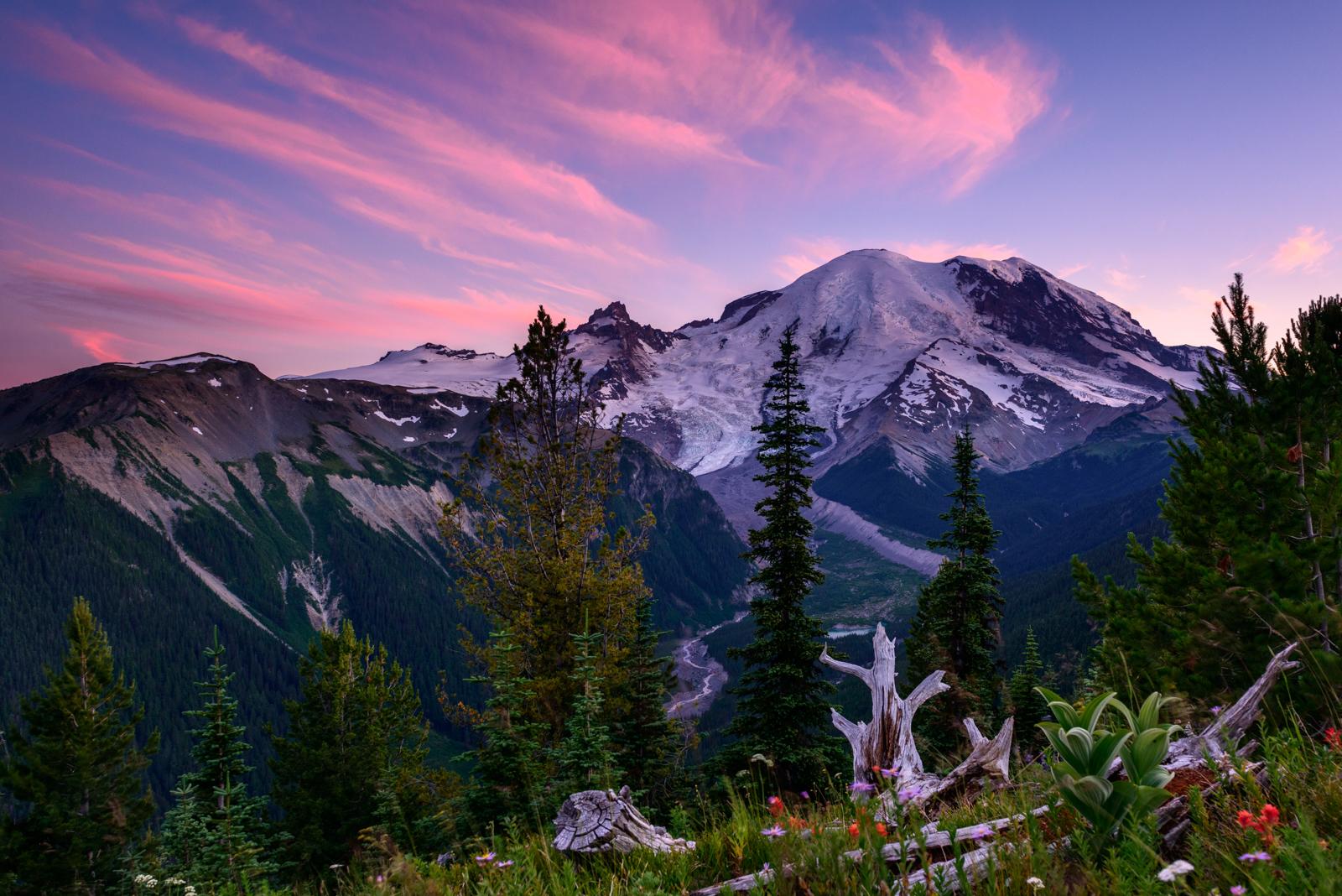
Mount Rainier National Park
National Park
Ascending to 14,410 feet above sea level, Mount Rainier stands as an icon in the Washington landscape. An active volcano, Mount Rainier is the most glaciated peak in the contiguous U.S.A., spawning fi...
8 mi from route
~20 min detour
$30
near mile 40.2
Park Closure: Paradise Road Status: Gate at Longmire CLOSED today for public safety
Park Closure: Starting Monday, April 13, no water available at Paradise & Narada Falls.
Park data from the National Park Service API. Alerts update every 2 hours.
Fuel & Cost
Regular Gas
$40.71 one way
$81.41 round trip
$5.32/gal25.4 MPG avg68 kg CO2
Fuel Type
$/gal
One Way
Round Trip
midgrade
$5.58
$42.69
$85.38
premium
$5.77
$44.17
$88.34
diesel
$5.61
$42.94
$85.89
No toll roads detected on this route.
Estimated Trip Cost (one way, 1 person)
Fuel
$41
Meals
$25–$50
Total
$66–$91
Rough estimate based on US averages. Hotel $80–$140/night, meals $25–$50/day.
Estimated CO2 emission: 68.1 kg one way.
Prices: EIA weekly data, 2026-04-13.
Driving Electric?
About $20 in charging
· 0 stops
· 66% less CO2
Vehicle Type
kWh
Stops
DC Fast
Home Charge
Average EV
58.3
0
$20.42
$9.34
Efficient EV
48.6
0
$17.02
$7.78
EV Truck/SUV
77.8
0
$27.23
$12.45
Gas CO2
68 kg
EV CO2
23 kg (66% less)
This trip is well within single-charge range for most EVs. No charging stops needed if you start fully charged.
DC fast charging avg $0.35/kWh. Home charging avg $0.16/kWh. US grid CO2: 0.39 kg/kWh.
Travel Intel
Current conditions at both ends of the drive.
Forecast as of Apr 15, 2026
Origin
Enumclaw, WA
Late night
in Enumclaw on Saturday
Local time
12:17 AM
PDT
Current temp
65°F
Unavailable
Live forecast
Destination
Kennewick, WA
Late night
in Kennewick on Saturday
Local time
12:17 AM
PDT
Current temp
51°F
Unavailable
Live forecast
Seasonal Notes
Summer travel usually means heavier construction, hotter rest stops, and busier weekend traffic around major cities.
Winter travel shortens daylight, so a route that looks manageable on paper can feel much longer after dark.
Holiday weekends tend to make both departure and arrival windows slower than the raw route time suggests.
Time zone
Same local time
Origin and destination are on the same clock, so arrival timing is easier to judge at a glance.
Temperature spread
14 degrees cooler at arrival
A meaningful temperature swing is a good cue to rethink layers, water, and how soon you want to arrive.
Road read
4h 17m on the road
An early start around 7-8 AM gets you there with plenty of daylight left.
Weather data from the National Weather Service. Conditions may change; check closer to your travel date.
Frequently Asked Questions
The drive from Enumclaw, WA to Kennewick, WA covers 194.5 miles and takes about 4h 17m without stops. Add 15-30 minutes for a fuel or rest stop on longer drives.
The main roads are I 82, State Route 410, US 12. Most of the drive stays on highways, so watch for ramps and exits.
This is a comfortable same-day trip.
The midpoint is about 97.2 miles from Enumclaw, WA. Look for rest areas, gas stations, or food options near the halfway mark.
At current regular gas prices, expect to spend about $40.71 one way. This estimate uses 25.4 MPG — your actual cost will vary with your vehicle's fuel efficiency and current gas prices.
An early start around 7-8 AM gets you there with plenty of daylight left. A late afternoon start means arriving after dark. Morning is better.
Plan about 1 meaningful break for fuel, food, or rest. Plan on a short reset every 3 to 4 hours to stay fresh behind the wheel.
This is a straightforward 4h 17m drive. You will face about 11 decision points, but nothing that requires special attention if you follow navigation.
The main spots that need attention: at 0.1 miles (Initial Avenue): Navigation decision point; at 0.1 miles (Cole Street): Navigation decision point; at 0.5 miles (WA 410 / Roosevelt Avenue): Navigation decision point.
Between Enumclaw, WA and Kennewick, WA, road signs point toward I‑182 East and Pasco.
Yes. Nearby national parks include Mount Rainier National Park.
How this page is built
Compiled by the Trip.ovh planning team at COD Solutions Oy from open government datasets — OSRM over OpenStreetMap for geometry, EIA for fuel prices, and NPS for national parks. See our methodology for refresh cadence and limitations.