Origin
Flagstaff, AZ
Afternoon in Flagstaff on Saturday
Local time
1:17 PM
MST
Current temp
64°F
Unavailable
Live forecast
Compiled and reviewed by the Trip.ovh planning team at COD Solutions Oy · Last reviewed Apr 18, 2026 · Editorial standards
Drive Time
5h 51m
Distance
329 mi
530 km
Drive Score
9/10
Great drive
Same Day?
Yes, doable
Fuel Cost
$66
one way
EV Charging
Unknown
Estimated drive times based on typical traffic patterns. Actual times may vary with weather, construction, and real-time conditions.

Flagstaff, AZ
Wikimedia Commons

Sierra Vista, AZ
Leslie del Moral
The drive from Flagstaff, AZ to Sierra Vista, AZ covers 329 miles and takes about 5h 51m behind the wheel. This route is realistic as a one-day drive if you keep your stops efficient.
The route leans on Arizona Veterans Highway, Casa Grande-Tucson Highway, Tucson-Benson Highway for much of the mileage, and the overall profile is mostly surface roads. The longest uninterrupted segment is about 93.9 miles on Arizona Veterans Highway. At current regular gas prices, budget about $65.54 one way before food or hotel costs.
Trip Pace
Same-day drive is realistic
A same-day return is possible, but it will make for a full day on the road.
Break Rhythm
1 planned break
Plan on a short reset every 3 to 4 hours to stay fresh behind the wheel.
Midpoint
164.5 miles from Flagstaff, AZ
A natural place for your longest stop of the day , about 2h 54m into the drive .
| Road | Distance | Duration |
|---|---|---|
| Arizona Veterans Highway | 93.9 mi | 1h 34m |
| Casa Grande-Tucson Highway | 54.6 mi | 55m |
| Tucson-Benson Highway | 41.4 mi | 43m |
| Black Canyon Freeway | 38.4 mi | 42m |
| Phoenix-Casa Grande Highway | 37.8 mi | 38m |
| Maricopa Freeway | 16.3 mi | 18m |
| State Route 90 | 14.9 mi | 17m |
| Huachuca Boulevard | 9.1 mi | 10m |
Step-by-step road directions between Flagstaff, AZ and Sierra Vista, AZ.
Start on US 180; I 40 Bus; US 66 Hist
Turn slight left onto South Milton Road
Continue on I 17; AZ 79
Continue on I 17
Continue on I 17
Continue on I 17
Continue on I 17
Continue on I 17; US 60
Continue on I 10
Continue on I 10
Continue on I 10
Continue on I 10
Take the exit
Turn right onto AZ 90
Continue on AZ 90
Continue on AZ 90
Continue on AZ 90
Continue on AZ 90
Continue on Buffalo Soldier Trail
Continue on Buffalo Solder Trail
Turn straight onto Buffalo Soldier Trail
Turn left onto West Fry Boulevard
Continue on West Fry Boulevard
Turn left
Arrive at destination
Morning Departure
An early start around 7-8 AM gets you there with plenty of daylight left.
Evening Departure
A late afternoon start means arriving after dark. Morning is better.
This is a comfortable same-day trip.
Departure
Before you leave
Start with fuel, water, and navigation already sorted so the first hour feels easy.
First stop
Around 72 miles or 1h 15m in
Use this first pause for coffee, a restroom break, and a quick traffic check ahead.
Halfway reset
Around 164.5 miles or 2h 54m in
This is the best place for your longest stop, a real meal, and a full fuel check.
Final approach
Final hour starts around 4h 43m
Traffic, exits, and arrival timing usually matter more near Sierra Vista, AZ than in the middle of the route.
Open the route before leaving Flagstaff, AZ so your first major turns are already loaded.
Leave with enough water and a charging cable within reach, not packed away.
Check your fuel range against the first long segment, especially if you are starting outside city service areas.
Day 1
Settle into the route from Flagstaff, AZ
This is one driving day of about 329 miles and 5h 51m.
Rest stops, refuel points, and overnight suggestions along this route.

Mid-route town
Meal stop
165 mi into the route
Best for: Lunch, fuel, and a longer reset
This sits close to the middle of the route, so it works well for the longest stop of the day.
A short stop after about 72 miles helps settle the day before fatigue starts building.
The midpoint is around 164.5 miles from Flagstaff, AZ, which is a good place for a longer meal and fuel stop.
Before the longest stretch
Fuel checkTop up before Arizona Veterans Highway if your tank is already low. That segment runs about 93.9 miles.
These stop ideas are pacing suggestions — the exact town or exit can change with traffic, hotel plans, and fuel range.
5 decision points cluster between mile 0.1 and 329 — GPS handles the exact turns, but know they're coming. Your lane choice matters more than the turn itself.
Turn slight left onto South Milton Road
Lane positioning matters here
Take the exit toward AZ 90 East: Fort Huachuca, Sierra Vista
Exit ramp - move to the correct lane early. Multiple destination signs - pick the right one
Turn right onto AZ 90 / South State Highway 90
Navigation decision point
Turn left onto West Fry Boulevard
Navigation decision point
Turn left
Navigation decision point
Regular Gas
$65.54 one way
$131.08 round trip
| Fuel Type | $/gal | One Way | Round Trip |
|---|---|---|---|
| midgrade | $5.36 | $69.36 | $138.72 |
| premium | $5.59 | $72.42 | $144.84 |
| diesel | $5.61 | $72.64 | $145.28 |
No toll roads detected on this route.
Estimated Trip Cost (one way, 1 person)
Fuel
$66
Meals
$25–$50
Total
$91–$116
Rough estimate based on US averages. Hotel $80–$140/night, meals $25–$50/day.
Estimated CO2 emission: 115.1 kg one way. Prices: EIA weekly data, 2026-04-13.
Driving Electric?
About $35 in charging · 1 stop · 67% less CO2
| Vehicle Type | kWh | Stops | DC Fast | Home Charge |
|---|---|---|---|---|
| Average EV | 98.7 | 1 | $34.55 | $15.79 |
| Efficient EV | 82.3 | 0 | $28.79 | $13.16 |
| EV Truck/SUV | 131.6 | 1 | $46.06 | $21.06 |
Gas CO2
115 kg
EV CO2
38 kg (67% less)
Plan for 1 charging stop. A 30-minute DC fast charge mid-route should be enough to complete the trip comfortably.
DC fast charging avg $0.35/kWh. Home charging avg $0.16/kWh. US grid CO2: 0.39 kg/kWh.
Current conditions at both ends of the drive.
Origin
Afternoon in Flagstaff on Saturday
Local time
1:17 PM
MST
Current temp
64°F
Unavailable
Destination
Afternoon in Sierra Vista on Saturday
Local time
1:17 PM
MST
Current temp
51°F
Unavailable
Seasonal Notes
Summer travel usually means heavier construction, hotter rest stops, and busier weekend traffic around major cities.
Winter travel shortens daylight, so a route that looks manageable on paper can feel much longer after dark.
Holiday weekends tend to make both departure and arrival windows slower than the raw route time suggests.
Time zone
Origin and destination are on the same clock, so arrival timing is easier to judge at a glance.
Temperature spread
A meaningful temperature swing is a good cue to rethink layers, water, and how soon you want to arrive.
Road read
An early start around 7-8 AM gets you there with plenty of daylight left.
Weather data from the National Weather Service. Conditions may change; check closer to your travel date.
Worth a detour if your schedule allows.
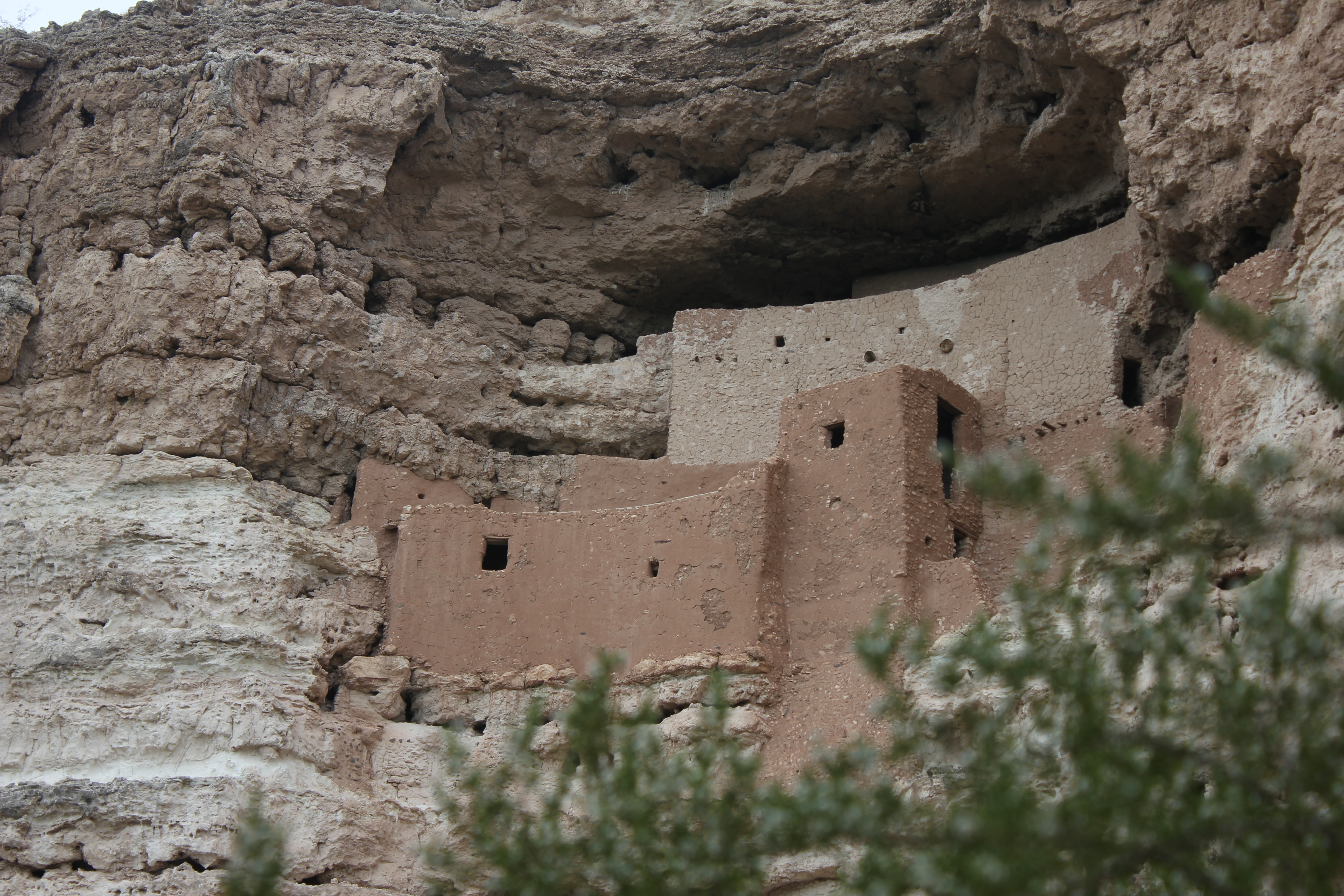
National Monument
Established December 8, 1906, Montezuma Castle is the third National Monument dedicated to preserving Native American culture. This 20 room high-rise apartment, nestled into a towering limestone cliff...
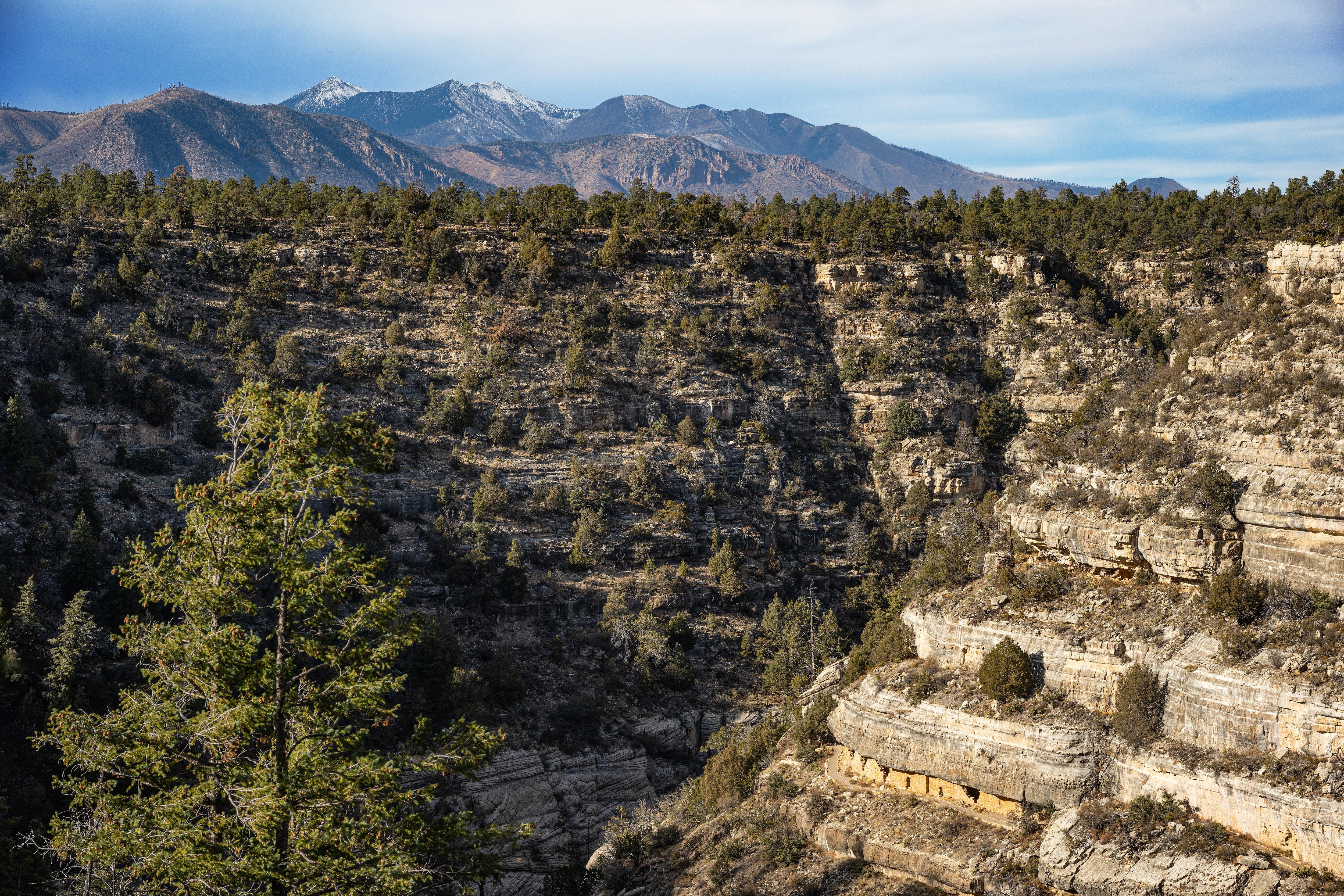
National Monument
Since time immemorial, Indigenous Peoples have lived and traveled throughout Walnut Canyon’s dynamic landscape. Vibrant communities built their homes in the cliffs and farmed along the canyon’s rim. T...

National Park
Tucson, Arizona is home to the nation's largest cacti. The giant saguaro is the universal symbol of the American west. These majestic plants, found only in a small portion of the United States, are pr...

National Monument
An Ancestral Sonoran Desert People's farming community and "Great House" are preserved at Casa Grande Ruins. Whether a gathering place for people or simply a waypoint marker in an extensive system of...
National Memorial
It was a journey of conquest filled with exploration, wonder - and cruelty. Inspired by tales of vast cities of gold, 339 European soldiers and over a thousand Aztec allies embarked on an epic journey...
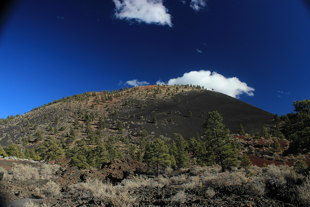
National Monument
The lava flow lies on the land like a dream, a wonderland of rock. A thousand years ago the ground was torn open and lava erupted into the sky, forever changing the landscape and the lives of the peop...
Park data from the National Park Service API. Alerts update every 2 hours.
329 mi in 5h 51m across surface roads — expect steady turns and local traffic rather than long highway runs.
Expect a hands-on drive with frequent turns and local roads rather than long highway stretches. There are only a few real navigation decisions along the way. The trickiest moment comes around 0.1 miles in near South Milton Road.
Easy - simple navigation with a manageable amount of wheel time
Balances navigation complexity with total wheel time.
This is a straightforward 5h 51m drive. You will face about 5 decision points, but nothing that requires special attention if you follow navigation.
Where does it get tricky?
The main spots that need attention: at 0.1 miles (South Milton Road): Lane positioning matters here; at 299.4 miles: Exit ramp - move to the correct lane early. Multiple destination signs - pick the right one; at 300 miles (AZ 90 / South State Highway 90): Navigation decision point.
High-altitude sections with notable climbs
Total Climb
3,580 ft
Total Descent
5,843 ft
Highest Point
6,900 ft
Elevation Range
5,843 ft
Flagstaff is a city of over 75,000 people (2019) near the San Francisco Peaks mountain range of northern Arizona and the Grand Canyon. At an altitude of 6,990 ft (2,130 m), Flagstaff and much of the surrounding region are substantially cooler than the low desert that dominates the southern part of the state. Though still dry by east coast standards, enough rain and snow falls in the area to allow a forest of ponderosa pine trees to cover the landscape. Winters tend to be cold, and heavy snowfall is expected on an annual basis.
Sierra Vista (Spanish: Mountain View) is a city in Southeast Arizona and the commercial hub of the region, making it a convenient base from which to explore the area. It is perhaps best known for historic Fort Huachuca, established in 1877 during the Apache Wars. Although still an active U.S. Army military base, its two military museums and historic cemetery are open to the general public. The landscape around the city is typical for the Southwestern United States, and the nearby mountains and canyons can be explored on foot, by bike, or on horseback. Because it is a major stopover point on avian migration routes, the area is popular with avid birdwatchers and naturalists, and is known as the "Hummingbird Capital of America".
City content from Wikivoyage (CC BY-SA 4.0) and Wikidata (CC0).
Weekend Trip
Doable as a same-day drive at 5h 51m. Total distance: 329 miles.
Family Friendly
Moderate complexity with 1 natural rest stops along the way.
Solo Traveler
5h 51m drive, comfortable solo distance.
First-Time Driver
Mostly highway driving (23%). Straightforward navigation.
Scenic Drive
Mostly surface roads route profile with national parks nearby.
Compiled by the Trip.ovh planning team at COD Solutions Oy from open government datasets — OSRM over OpenStreetMap for geometry, EIA for fuel prices, USGS 3DEP for elevation, and NPS for national parks. See our methodology for refresh cadence and limitations.
Was this helpful?
Thanks for your feedback!
Your tip has been submitted. Thanks!
/500
Recent Tips
·
Explore more options from Flagstaff, AZ or browse trips ending in Sierra Vista, AZ.
Looking for more statewide routes? Browse AZ road trips.